AppsRunner
-
Posts
2,420 -
Joined
-
Last visited
Content Type
Profiles
Blogs
Forums
American Weather
Media Demo
Store
Gallery
Everything posted by AppsRunner
-
Upstate/Eastern New York
AppsRunner replied to BuffaloWeather's topic in Upstate New York/Pennsylvania
A few strikes on the oswego campus the last couple hours. I’m sure they’re having fun. -
Fall/Winter 2018-19 Complaint/Banter Thread
AppsRunner replied to IWXwx's topic in Lakes/Ohio Valley
Other than the January 9-12 system, I can't recall any other storms trending northwest in the final 24-48 hours. It's been odd. -
Final total here about 3-3.5". Still have yet to eclipse 4" from an event.
-
-SN started about 30 minutes ago, we're probably down to moderate SN with about a 1/2 to 3/4 SM visibility. Really good dendrites to start the event off.
-
At least some slight improvements on the west end in the latest RAP/HRRR runs. Cyclone needs to turn up his magnet to a higher setting this time around.
-
We know what you're gonna end up with Trying to break my event high of 4" with this storm.
-
Fall/Winter 2018-19 Complaint/Banter Thread
AppsRunner replied to IWXwx's topic in Lakes/Ohio Valley
"King Euro"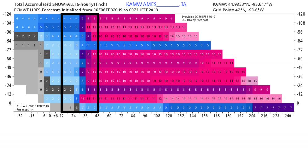
-
Nothing like your 100 mile east shift with the QPF on the euro 24 hours before precip arrives.
-
It seems like this is every storm here in Iowa this winter. I have no doubts you'll pull out 6" or so somehow
-
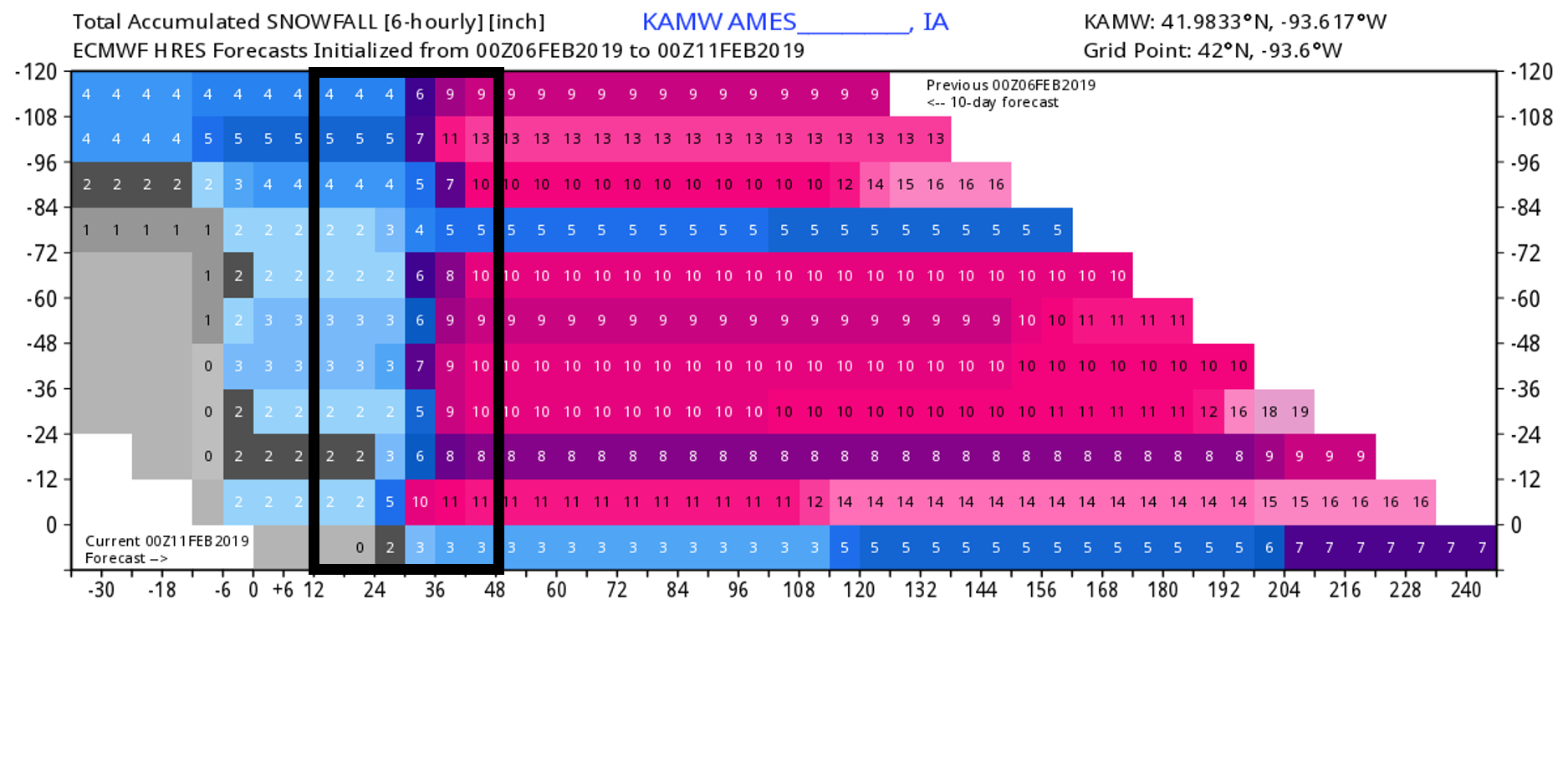
Pretty good agreement between the UKMET/GEM/ECM across Iowa into E MN/W WI with a swath of 0.5-1.25" of QPF stretching from southwest Iowa up to La Crosse or so. Seems if any storm is going to be the big one of the season for DSM/LSE it'd be this one.
-
Must've stolen some of your luck. Somewhere around 3.5" or so here. DMX had 4.5" at their office. Really nice dendrites this morning during the good rates this morning.
-
The NAM has repeatedly been underdoing precip in its long range, I have little faith in its solution outside 48 hours. Meanwhile the GFS/GEM are largely similar to previous runs
-
That's two events using Kuchera method on a model that's been wetter than most other guidance.
-
The FV-3 is spitting out ridiculous QPF amounts for the next two systems. It has over a half inch of liquid for the weekend threat and 1.5"+ for the Tuesday storm. Seems a bit far fetched.
-
Figured it's worth starting a thread as we're now within a week. Good support for a storm somewhere in the subforum early next week. Euro/GFS/FV3 all point to a potentially significant winter storm, and the euro ensembles have some strong solutions going from the OK panhandle to as far west as MSP and as far east as BUF.
-
We've picked up a glaze of ice and a trace of sleet so far, but it's still icy. Round two is looking like it could be a heavy burst of snow tomorrow morning/afternoon across Iowa, though the NAM isn't fully onboard yet. The rest of the models look good to at least get the grass white again.
-
Upstate/Eastern New York
AppsRunner replied to BuffaloWeather's topic in Upstate New York/Pennsylvania
What? The campus got a couple inches. Where did you see a foot? -
Upstate/Eastern New York
AppsRunner replied to BuffaloWeather's topic in Upstate New York/Pennsylvania
Band still drifting/pivoting south, and still quite intense. Lake Ontario never disappoints in terms of actual snowfall rates. -
Upstate/Eastern New York
AppsRunner replied to BuffaloWeather's topic in Upstate New York/Pennsylvania
Watertown picked up another 7.4” in the last two hours, CoCoRaHS says just under 3 feet now as a total. Finally shifting south -
Upstate/Eastern New York
AppsRunner replied to BuffaloWeather's topic in Upstate New York/Pennsylvania
KART picked up 0.13" liquid equivalent last hour. The two hours when they got about 3.5"/hr. were 0.07 and 0.09". I'm still not seeing any significant movement in satellite upstream at the moment and there seems to be an excellent convergence zone right over Watertown. @WxWatcher007 I would fully expect this continue for at least another hour or so before things gradually shift. -
Upstate/Eastern New York
AppsRunner replied to BuffaloWeather's topic in Upstate New York/Pennsylvania
CoCoRaHS and another Spotter in Watertown reporting 3.6"/hr. and 7.1" the last two hours. -
Upstate/Eastern New York
AppsRunner replied to BuffaloWeather's topic in Upstate New York/Pennsylvania
Because Pulaski/Sandy Creek/Redfield are going to get warning criteria snow tonight, and they are in Oswego county. -
Upstate/Eastern New York
AppsRunner replied to BuffaloWeather's topic in Upstate New York/Pennsylvania
I've been trying to tell you Redfield/Tug Hill folks over and over again that your snow is still on track. Should have a good portion of tonight/tomorrow to pick up accumulations. -
Upstate/Eastern New York
AppsRunner replied to BuffaloWeather's topic in Upstate New York/Pennsylvania
I think what's most impressive is how well the KART ASOS is picking up liquid. 0.09" last hour and 0.07" this hour. Even on a conservative 20:1 ratio that's about 2"/hr. Chances are it's closer to 3-4" now. -
Upstate/Eastern New York
AppsRunner replied to BuffaloWeather's topic in Upstate New York/Pennsylvania
My two friends chasing say they can't even see a thing out the car window. Sitting I-81 at Route 3 in W Watertown. @WxWatcher007 how much fun are you having?