
AppsRunner
-
Posts
2,420 -
Joined
-
Last visited
Content Type
Profiles
Blogs
Forums
American Weather
Media Demo
Store
Gallery
Everything posted by AppsRunner
-
Upstate/Eastern New York
AppsRunner replied to BuffaloWeather's topic in Upstate New York/Pennsylvania
One where I can keep my red tag -
Upstate/Eastern New York
AppsRunner replied to BuffaloWeather's topic in Upstate New York/Pennsylvania
I've spent the last three days thinking about how I can find a job in BUF or CNY. -
Upstate/Eastern New York
AppsRunner replied to BuffaloWeather's topic in Upstate New York/Pennsylvania
Told you to be patient! Band probably will swing all the way through Watertown for a brief period of time before it slowly works its way south again later this afternoon -
Upstate/Eastern New York
AppsRunner replied to BuffaloWeather's topic in Upstate New York/Pennsylvania
I assume you're probably a new met student at SUNY Oswego? PM me if you ever want, recent grad. I'd say less than an inch. At least classes were cancelled today. You're going to pick up some snow. The HRRR is bad with LES intensity/placement/inland extent. I can't say I ever really use it even during the events themselves. -
Upstate/Eastern New York
AppsRunner replied to BuffaloWeather's topic in Upstate New York/Pennsylvania
I think you'll even make a run at getting into this band within the next couple hours if it continues to lift further north. If you have a car and want to attempt to drive to Adams or Adams Center you'll have a good time. Depends what your definition of "appreciable" is. I'd be willing to bet Redfield gets at least 12", there's a 12-18 hour long period of better aligned flow tonight into tomorrow. -
Upstate/Eastern New York
AppsRunner replied to BuffaloWeather's topic in Upstate New York/Pennsylvania
For those downwind of Ontario not really seeing much right now... Band should lift at least a little northward through the afternoon and evening as winds start to back a bit more. Watertown got pretty unlucky yesterday where and east-west oriented band managed to stay due north of them for a while, and there's a pretty impressive snowfall gradient there by now. I'd have to imagine the band lifts to about Watertown/Carthage this evening before winds become a bit more WNWerly by late this evening. Flow looks fairly well aligned through most of the night and would point towards areas of central/northern Oswego county finally getting some appreciable snows. Inversion heights start to fall overnight so we aren't looking at the 2-4"/hr. in the core of the band right now, but still could see 2"/hr. rates for an extended period of time if the band stays fairly steady state. By Friday afternoon we may see one last swing up north as the band shrinks/weakens and warm air advection moves in. Still generally like the idea of about 24-36 from Sandy Creek to Adams Center and about 12-24 anywhere within 5 miles of that, especially in the Tug. -
Upstate/Eastern New York
AppsRunner replied to BuffaloWeather's topic in Upstate New York/Pennsylvania
@Phillifan22 and a few others are at the Gathering Place and said about 1.75"/hr. or so -
Upstate/Eastern New York
AppsRunner replied to BuffaloWeather's topic in Upstate New York/Pennsylvania
I had several experiences with that in Oswego, and a couple times chasing through Pulaski/Sandy Creek. -
Looks like a patch of low clouds is moving across western/central Iowa right now. We got to -24 for 1/30, 1/31 we are at -22.
-
Upstate/Eastern New York
AppsRunner replied to BuffaloWeather's topic in Upstate New York/Pennsylvania
Patience. It's going to take its time, but it'll be worth it. Might be best off to grab some sleep now while you can. -
Back down to -22 in Ames. Will probably re set the record low for today - that ties it from when it was set in the morning.
-
We breifly dropped to -18 but we’re up to -14 again.
-
Upstate/Eastern New York
AppsRunner replied to BuffaloWeather's topic in Upstate New York/Pennsylvania
Watertown has to be absolutely crushing right now. -
Upstate/Eastern New York
AppsRunner replied to BuffaloWeather's topic in Upstate New York/Pennsylvania
The airport just west of town has been reporting +SN on an off for a while. It's going to be a fun night. BUF's SOO put out an SPS about an hour ago discussing the band consolidation/strengthening through the evening/overnight and setting up near Watertown. -
Upstate/Eastern New York
AppsRunner replied to BuffaloWeather's topic in Upstate New York/Pennsylvania
Looks like that main LES band moved back N a bit, although still a touch south. For as many awful radar shots as I've seen for Lackawanna/West Seneca, if this primary band can actually move in they'll be fine. Patience. -
Upstate/Eastern New York
AppsRunner replied to BuffaloWeather's topic in Upstate New York/Pennsylvania
My favorite type of METAR: KBUF 302054Z 24020G34KT 0SM R23/0500V1200FT +SN BLSN -
Upstate/Eastern New York
AppsRunner replied to BuffaloWeather's topic in Upstate New York/Pennsylvania
KROC managed to get to +SN last hour. BUF back down to 1/16 SM. -
Up to -12 right now, which has bumped wind chills to near -30. At least it's sunny
-
Upstate/Eastern New York
AppsRunner replied to BuffaloWeather's topic in Upstate New York/Pennsylvania
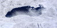
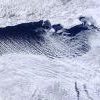
The original cloud streets on the west end of Erie starting to orient back to the WSW as opposed to the due W earlier. Would expect the main band to lift back north a little bit. -
Upstate/Eastern New York
AppsRunner replied to BuffaloWeather's topic in Upstate New York/Pennsylvania
You can really see the areas that are still open on the west end of Lake Erie right now that are the main sources for the initial LE clouds near/north of Kelleys Island and Put-in-Bay. It's hard to say for sure but it looks like the north end of Erie by Long Point is also almost fully open which is why we have the double band structure right now, and even 250/260ish winds could keep that secondary band in BUF for a while longer, if it can manage to hold together. -
Upstate/Eastern New York
AppsRunner replied to BuffaloWeather's topic in Upstate New York/Pennsylvania
What's the flake size been like so far around BUF/southtowns? @BuffaloWeather - You'd probably be in the best spot for dendritic growth. Also pretty fun seeing BUF at 0F reporting 1/8 or 1/16 SM with heavy snow. Regardless of totals this is going to be a high end event, especially if it sticks around the metro through rush hour. -
Upstate/Eastern New York
AppsRunner replied to BuffaloWeather's topic in Upstate New York/Pennsylvania
Yeah, I'd think so. There still seems to be a bit of shear, especially above 800mb this morning/afternoon that may hinder development more than I originally thought, but I would venture that the band sits over Watertown several hours each day, so it won't be 24" in one shot but over the course of this afternoon/tonight/tomorrow/tomorrow night. I also still think the models have a bit of a south bias overall with their QPF placement, which seems to always be a common theme. I have a few friends @Phillifan22 + a couple others headed out to Adams or so by tonight, and I've been disagreeing a bit on where their best shot is to set up. -
Upstate/Eastern New York
AppsRunner replied to BuffaloWeather's topic in Upstate New York/Pennsylvania
14" just north of Tonawanda. That's impressive. -
Only managed -22/-48 in Ames. I feel a little left out not getting to -50. Euro was a few degrees too cold here overnight, wonder how it will handle the radiational cooling overnight tonight with its current forecast of -27.
-
Upstate/Eastern New York
AppsRunner replied to BuffaloWeather's topic in Upstate New York/Pennsylvania
Only 24" more for my forecast to be right


