

SnowGoose69
-
Posts
16,236 -
Joined
-
Last visited
Content Type
Profiles
Blogs
Forums
American Weather
Media Demo
Store
Gallery
Posts posted by SnowGoose69
-
-
Just now, Snow88 said:
So far so good on the 0z models
If it ends up being a continuing trend this could be a decent event but we would continued ticks here for the next 36 hours.
-
 1
1
-
-
I expected the NW tick back but I'm still not sold we see anything much further with it.
-
46 minutes ago, 78Blizzard said:
Given this winter to date, it probably will.
Flow is way too fast. Better chance this corrects back east I think
-
 1
1
-
-
3 minutes ago, Allsnow said:
You can see substance developing in the warm phases on the roundy plots. Let’s hope that’s the case after we get out of p6. But it’s in the long range and convection is unpredictable

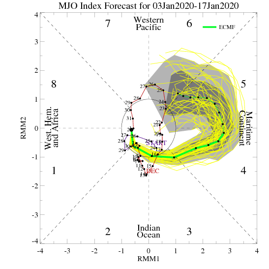
If you back 5-7 days ago and check the ECMWF MJO forecasts you can see why they are so unpredictable. The only thing it still appears to have the same is that it goes to 4-5 but how it gets there has become delayed and it goes through 3 now first. It just tells you anything beyond Day 7 on those forecasts is iffy.
-
1
-
-
2 minutes ago, PB-99 said:
A good sign is that starting on day 13 on the GEFS , the Scan ridge is showing signs of forcing higher heights towards Greenland. It begins to help force the trough south which presses on the SE ridge d 13 - d 15.
Ultimately it’ll probably come down to the MJO from 1/20 or 1/25 onward. If it goes back through 4-5-6 this winter is done. If it stays quiet it could possibly be a big 6-8 week period
-
2
-
-
59 minutes ago, PB-99 said:
Even when I look at the EPS and GEFS stringing LP out through the N/E it just looks like L/R lake cutters that drags a C/F through the area for a few days.
Can`t have the negative in the SW unless the troughs that come out are all positively tilted and then can run the baroclinic zone.
Even then I never like that look without blocking, the flow tends to ride further N as we get closer.
The pattern is pretty active which may prevent there being absurd warm anomalies this month, even for places in the SE US because as long as we keep getting systems ejecting out of that trof we are going to continue having FROPAs in the East. Even if they’re inducing modified Pac air it doesn’t seem at any point we see a sustained SER with bright sunshine for days on end
-
2
-
-
3 minutes ago, psuhoffman said:
I think whether we salvage a decent winter pattern sometime the second half depends on what the MJO does. Right now the surge into a high amplitude MC wave is feeding the central pac ridge. What happens late January into Feb depends on what happens with that wave. The long range euro implies it dies then recycles back towards the warm phases in early Feb.
That would probably kill winter. We might get a transient shot at something during the week the MJO wave relaxes but by the time any decent pattern could establish the wave would be surging back into warm phases, pumping the pac ridge and its winter over at that point..being early Feb and about to recycle right back where we are now. That is the 2002/2008/2012 option. And the still warming water near the MC really bothers me because it gives credibility to that possibility.
If the MJO can survive into phase 8/1/2/3 then we will likely see things evolve better. I do see signs that the Atlantic wants to help, but the current mjo state is going to fight that off. The pacific will defy any wave breaking attempts from the atlantic so long as we have a high amplitude phase 4/5/6. If we can get an appreciable period either without MJO influence, or better cold phase influence I do think the atlantic will be able to bully the pattern in our favor. Last nights euro run trended more favorably wrt the mjo progression.
Ironically, and its why the GFS backed off on its colder look from yesterday, the GEFS flipped places with the EPS and now shows the MJO cycling in the warm phases with no end in sight. I think how this resolves is the key to our prospects for improvement. If we see the MJO trend towards a workable look in a week or so we might be ok. If we see it start to show signs of wanting to recycle (basically a standing wave in the MC) in the warm phases all winter we are in big big trouble.
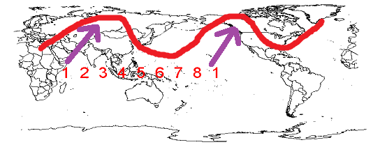
Just another MJO thought (maybe someone above my pay grade can answer this) but I was thinking about how the warm phases have a much higher correlation to temps here than the cold phases. I wonder how much of that is because the warm phases directly impact the pacific ridge amplitude/location but there are two cold phase locations. The phase 8/1 out near the dateline would more directly impact our pattern by forcing the ridge east into the EPO/PNA domain, where the cold phase waves off Africa would only indirectly do that by placing a ridge in a favorable location in Asia to way downstream effect North America but there is way more that can disrupt that between there and here. I wonder if we only looked at MJO forcing near the dateline if it would have a higher correlation (similar to the MC forcing) than when we include all cold phases, some of which are from the Indian Ocean forcing. Maybe someone out there knows, I've not seen any study on this.
I am not saying I think that will have much bearing on our outcome. There is a more favorable SST to IO forcing vs Dateline. Unfortunately the waters near the dateline in the PAC are cooling...not what we want. But I think there are enough signs the atlantic wants to help that if we can just get the MJO out of the "killing us" phases, even if its the less favorable IO forcing it would be enough. At least I hope.
I’m beginning to wonder if we need a major La Niña or El Niño event to shuffle the pacific SSTS so that we don’t have this same issue with the MJO winter after winter for the foreseeable future
-
2
-
-
Just now, Brian5671 said:
NAM is ugly-has very little precip and zero snow
It develops the system way too late. The 500 track though isn’t bad
-
2 minutes ago, HeadInTheClouds said:
Should I get the barbecue and patio furniture out?
Haha....have you seen the NAO the last 6-7 years in March and April?
-
2
-
-
Just now, SnoSki14 said:
We torched in a very low amplitude 4-6 pattern so imagine a much greater version of that.
The EPS looks ridiculous in the LR, we're talking 50s & 60s to even 70s for weeks that could start leading to early plant growth especially with no below freezing weather.
There’s no way the pattern will stay that warm for that long. My guess is by 2/1 it flips. TBH we may be better off just getting that miserable pattern in mid to late January vs what’s happened last few years where a massive SE ridge has occurred in February
-
1 hour ago, bluewave said:
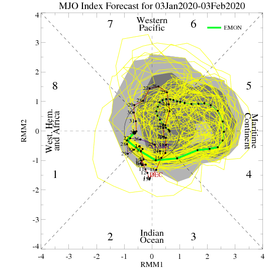
The Euro and GFS agree that the MJO could reach a +2 or greater amplitude in both phases 4 and 5. The last rime this occurred during January was 2013 and 2007. It would be nice if the February pattern improves like it did in those winters.


The Euro has been trending the last 2 days towards killing that wave quickly. It’s probably better for us than it going high amplitude into 6 and maybe taking forever to get to 7 or just spending forever in 5 and 6
-
1
-
-
9 hours ago, psuhoffman said:
Feb 24 1989 I think. Not sure why it busted. But it didn’t bust by that much it simply had a sharp back edge. Atlantic City had 19”. Cape May 24”. But where I was 35 miles NW of there nothing. Philly was always on the back edge because I remember the night before the forecast was 1-3 NW of the city. 4-8 in Philly. 8-14 SE and 12-18 at the shore. The back edge ended up with a tighter gradient and maybe 20-30 miles east of expected.
Oh yes that I knew. The one you mentioned though from 91-92 is the one I can’t recall the day but distinctly remember it busting.
-
On 12/31/2019 at 12:10 AM, Ralph Wiggum said:
We had classes cancelled just SW of Philly and were forecast 4-8" or 5-10" and got zilch....not a flurry, not a drop of rain. That was a tough pill to swallow...thanks for bringing it up lol.
I can’t recall what day it was but I vaguely remember this one. I want to say it was a Friday afternoon or evening in February or March and have no recollection of why it busted. We were supposed to get a decent amount up here too
-
5 hours ago, Go Kart Mozart said:
It's gonna be tough with the MJO progged to go into a high 4/5. Maybe things improve towards the last week in January. Was it 2007 or 2008 when we went from a mild January to a very cold and sleet-filled February?
While I believe it goes into 4/5 I am not sure on the amplitude. The tendency the last month or two has been for it to want to be lower amplitude than show 10-20 days out.
-
1 hour ago, Snow88 said:
Some people are canceling winter which is foolish this early.
Yeah February and March could be big months. January I would say is tossed at this stage but subject to change. The MJO looks to go into 4-5 and maybe 6 starting 1/7. That means probably no major effect from it til 1/12-1/14. Thereafter it’s at least 15 days til it either goes into the COD or into 7 so I would toss the remaining 2 weeks of the month and then see what happens thereafter. It remains possible that from 1/6 til the 12th or 14th some type of snow event could occur
-
1 hour ago, CoastalWx said:
Despite the snow storms, there is most certainly a cutter risk. In fact day 9-10 euro could easily go west. Sorry Ant. Not every storm will do so, but that’s what happens with a cold dump out west and in the Plains. It’s going to be a yo yo pattern. Maybe a touch of January 14?
The only way that storm doesn’t cut in that pattern is if the pattern is fluid and transient. There’s been a few storms over the years (never KUs because of the speed) that have run over 40-70 in a setup such as that. They usually occur right at the start of the cold outbreak which as we know is rare. In general when you see a pattern shift, even a brief one the snow event usually occurs several days or more in. Then immediately after the storm the ridge out west breaks down again it moves into the plains and we go right back to warm. If that ridge holds there for 7-10 days behind the storm and the pattern isn’t transient that thing cuts most of the time
-
9 minutes ago, bluewave said:
It looks like pretty good agreement between the Euro, GFS, and CMC on the MJO. Lingering mild phase 5-6 influence to start out January. Then a shift to colder a few days later after we go through phase 7-8. Followed by a shift back to mild with phase 4-5. So The January 1-15 progression should be mild...cold...mild. Exact dates of the quick transitions to be determined later. The GFS VP anomalies eventually get out of the the COD and over to 4-5 like the other models. The GFS can struggle with those RMM charts. That why I like to look at the VP anomalies.
If the Euro having that insane 4-5 passage is right this winter could very well be over. It basically starts it around 1/12. So figure you’re toast through 2/1 minimum if it’s that strong of a wave. My hunch though is that it won’t verify anything like that
-
3
-
-
The main hope now is that the ECMWF MJO forecast is wrong because if it’s not we might have a window 1/8-1/20 and then it’s gonna be over for 2-3 weeks again
-
1 hour ago, psuhoffman said:
@C.A.P.E. @Bob Chill @frd @WxUSAF
We are all seeing the same discouraging thing and hoping it’s temporary. I debated not even making this post (because att things look more like the not so good analogs I’m about to discuss) but the truth is the truth and if some can’t handle it oh well. But I will only say it once and then look for hopeful signs. (It’s not 100% doom and gloom)
That said if we look at the analogs to the current pacific look, the evidence suggests that it will prevail most of the winter. When that anomalous of a central pac ridge shows up this time of year it tends to be a dominant player for the remainder of met winter.
There are a set of analogs though that flipped colder and went in to at least a snowy period at some point later in winter. But they had something in common. NAO help. Even during the bad periods the NAO showed signs of being favorable. Later in winter the NAO was able to offset the central pac ridge by forcing the western trough to cut under the NAO ridging. This is the h5 look to the years with a similar pac look that went on to a decent snowy periods.

unfortunately the modeled pattern coming looks much closer to the years that went on to be total turds.

The difference is the NAO. If we don’t get any Atlantic side help history suggests we’re toast with the current look in the pac. And unfortunately history suggests that look is likely to persist much of winter. I tried to find examples of years with that ridge strength and alignment this time of year where the pac flipped...and it’s just not numerically likely.
Now the only silver lining is there were examples where the NAO looked bad temporarily then recovered but if the +AO/NAO locks in positive for more than 10 days or so in early January that eliminates all the decent analogs and pretty much throws us unto the dreg Years. Some of those years had some snow early before the pattern locked in and a couple had a fluke snow very late in March but they all were pretty much total crap through the core of winter.
I don’t like to say it but simply according to the analogs numerically if we don’t start to see signs of the AO/NAO flipping back negative within the next week or two at most...we’re likely looking at a dud year wrt snowfall.
Hopefully peoole know I don’t just give up on a season on a whim and in previous bad starts I held on because there were signs things could easily improve. And if we start to see either the pac or NAO improve in the next week everything I just said is out the window. But the numbers say if this current look locks in for any extended period in early January....well you get it.
I’m surprised 96-97 isn’t in there. I seem to recall some sort of massive central Pac ridge that screwed us but maybe it was further north. It may have been an Aleutian/Bering block which can be bad too
-
15 hours ago, psv88 said:
Bad idea, lease it. Buying a car is the worst possible investment, other than a boat.
Yup. I bought the first new car of my life in June of 2018 (sonata) and because I had no loan history at all at nearly age 40 and only one credit card I got a lousy 5.8% loan rate. To make it more shocking I payed 50% in cash too so my loan was for a lousy 14,500 and 2 banks despite a credit score of 740-750 straight up turned me down due to lack of history. People often ask me why did you not just pay the whole car off then? I said because I wanted to get some sort of history on my record before buying a house. I payed the loan off a few months ago in one shot. My credit score is now 812.
Meanwhile the 2018 Sonata has had some issues for sure. A couple of times it has not immediately started in cold weather and I've had to hit the button 4-5 times. Some folks in the Plains/Midwest last winter could not get them started at all and had to have the solenoid assemblies replaced. Oddly enough it was never recalled to this day.
-
On 12/19/2019 at 4:13 PM, LibertyBell said:
Maybe someone will remember the year this happened, I know it was in December.....
An arctic front passed through the day and there were snow squalls with almost completely clear skies during the day and high winds, but no accumulations.....
Then at night we had a rogue snow squall move in with partly cloudy skies and a near full moon around 10 PM. I remember seeing the weather on WPIX and there was a rogue band of snow around JFK and SW Nassau. It sat there for 2 hours and we had 2 inches of snow in that time, all the while seeing the moon pass through the clouds (or vice versa lol.) What date did this happen? It was somewhere between the mid 80s and mid 90s (prior to 92.)
My first thought when I read this was 12/4/91 or the 1/16/92 bust but this one I don't remember.
-
1
-
-
22 hours ago, LibertyBell said:
I think it happened before the 1993-94 winter.... I remember the Dec 26 1993 storm as being the only all snow event that winter for us lol. Was a low moving up the coast developing east of ACY dropping 4-5 inches of snow here.
I remember a coast to coast low that went east off of Norfolk that dropped 4-6 inches also, do you remember what year that might have been? I distinctly remember it because coast to coast lows passing south of us are pretty rare.
The 12/26/93 storm was miserably and I mean miserably handled by NOAA/local mets etc. They completely abandoned ship off a slight shift east in the 12Z guidance that morning despite the fact by noon the radar along the DE/MD coast was clearly west of the 12Z models. I think all warnings outside Suffolk got dropped and by 3-4pm it was obvious the snow was coming straight up the coast. They ended up having to put advisories back up by 7-8pm.
-
1
-
-
28 minutes ago, Winter Wizard said:
This one has I'm sure been overshadowed by more recent storms, but 10 years ago today, this was an all timer for Long Island and the mid-Atlantic and MECS for NYC.

That was dangerously close to being a catastrophe of a bust. The system started sliding more east than expected and nearly ending up missing a good part of the area. I remember that evening around 6pm sitting at home thinking this is really going to bust isn’t it? It ultimately slid far enough east that most of northern Jersey didn’t see major snows
-
On 12/17/2019 at 5:35 PM, WestBabylonWeather said:
I don’t remember 2000-2001 winter. I was in high school. I’m 33 now. I see we got over 50” but I still recall late 90s into early 2000s being terrible for weenies.
The 5 boroughs of NYC were never under a winter storm watch one time from March 1996 til 12/29/00. That shows you how pathetic things were in regards to winter storms in that period. January 2000 because the storm snuck up on us at the last second they went straight from nothing to a winter storm warning otherwise the streak would have been 11 months shorter
-
2
-

January 2020 General Discussions & Observations Thread
in New York City Metro
Posted
Its taking quite some time to reach the ground but someone might get a quick inch