

SnowGoose69
-
Posts
16,236 -
Joined
-
Last visited
Content Type
Profiles
Blogs
Forums
American Weather
Media Demo
Store
Gallery
Posts posted by SnowGoose69
-
-
Just now, Ericjcrash said:
The 96 measurement is still laughable.
There was some pretty nasty dry slotting from about NYC to Nassau for a time. Quite a few places there saw only 16-22 inches or so. I want to say BDR only reported 17-18. We’ve definitely had some oddball measurements over the years at the airports and NYC. That Newark measurement on 2/11/94 I think most agree was wrong. NYC’s measurement on 1/22/87 I had an NWS Met tell me 18-20 years ago they KNOW was wrong. Recently we obviously have some real awful ones but even before 2000 we saw occasional sloppy reporting
-
1 hour ago, Torch said:
No I meant” 78” , Friday 6 P.M 48 hours before the first flakes flew, the weather bureau had a forecast of light snow. Of course 24 hours later things changed, but back then it could have been seen as a surprise.
78 was forecast remarkably well for the time though the amounts weren’t. The LFM was the model which nailed it as it also did the 89 Thanksgiving storm which the other models mostly discounted. 78 was quickly setback though when the models blew the 1983 storm north of Philly. In fairness there wasn’t much computer advancement in those 5 years though. 1983 was somewhat of a benchmark though in that when the 00Z models ran that evening they shifted the entire storm well north and caught onto what was going on. At the time that was one of the first cases of the models ever doing that
-
 1
1
-
-
6 hours ago, Enigma said:
March 93 was showing consistently on models 6-7 days out. At that time, Euro and MRF were run once daily. I recall that MRF went out to 240 hr, Euro 168 hr.
At the time it was the first case ever of a major storm being modeled that far in advance. Once we got to 96-120 every model had it including the UKMET. Forecasting was still pretty bad in 1993. It improved significantly in the ensuing 3-5 years as a result of the Euro being more widely used as well as the ETA being worlds better than the LFM/NGM.
-
1
-
-
10 minutes ago, LibertyBell said:
I always forget that late Jan 2011 storm and should have added that to my list. I remember that one also came in two parts, with around 4-5 inches in the first part and another 15 inches in the second part.
Similar bust on part 1 to the December 2003 storm. Difference was part 1 of the 12/03 storm busted on temps while the first part of the January 2011 storm busted on QPF that no models saw. The 2nd part of that December 2003 storm though majorly disappointed. The mid levels sort of torched between part 1 and part 2 and the coastal wasn’t deep enough so snow growth was lousy and the CCB was spotty leading to two mega bands over ERN NJ near EWR and another near central LI. In between most places saw 3-5 inches, if that. The CCB in part 2 of January 2011 rivaled April 82/February 83. It was just insane snow rates and a gravity wave may have played a part too much like it did in February 83 and January 04
-
1
-
-
13 minutes ago, David Reimer said:
I wouldn't mind a switchover to sleet and snow in OUN at this point. This FZRA garbage needs to stop. We're starting to lose trees and I really don't want to flirt with power outages. It's all fun and pretty until the power goes out

I remember being there for the January 2010 storm and we were about 1-2 hours away from disaster and repeating 2007. Thankfully right as we were nearing it we flipped to sleet and avoided another mess. I think we got about 3/4 inch of ice between about 10am-1pm before we went over to sleet. Got 6-7, inches of snow the next day which was mostly unforecast outside of Mike Morgan who either got lucky or saw something nobody else did
-
18Z RGEM metogram has .70 snow for OKC
-
2
-
-
10 minutes ago, burgertime said:
This looks damn good. 12z RGM at 48 hours.....well before the storm is over. By the way I can't stress enough how SV is only $20 a month. Well worth the cost.
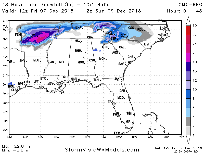
LOL is that 20 inches in Little Rock?
-
2 minutes ago, Cheeznado said:
Pinch me, I will be headed to AVL tomorrow very early- if they get over 18" (and that seems to be a growing consensus) it will be the biggest snow storm ever there- also I have never personally seen that much snow in one storm.
I definitely see potential in ATL Monday if the 12Z verified as shown (which it likely won't). There is a weak surface reflection off SAV along with the upper low coming across. Often times a weak surface reflection like that is all it takes to crank more moisture in than expected. I regularly saw that burn forecasters in OK often if you got a weak low to form in SE TX.
-
2
-
-
4 minutes ago, eyewall said:
The storm has busted so far in the Southern Plains.
That is more due to the ULL feature not developing as well. I would not expect that to translate downstream assuming the surface low and WAA is decent
-
1
-
-
21 minutes ago, Waiting on snow said:
I remember closing in on the Feb 2014 event that the upper layers started coming in colder as the medium range models came in play. I don't remember exactly how far out though. Being 54 hrs out or so now you would think tonight at Oz something need to start happening and definitely by 12z tomorrow. If not I think it'll be a lot of heartbreak come go time for the 85 camp. You can't go into one of these storms being modeled on the edge. Cutoff most likely ends up nw of where modeled.
I remember that event because it was so easy to forecast for ATL bexause the wedge was so massive. There was zero doubt as to if it would get there. As it turned out it was so strong they saw mostly PL instead of FZRA
-
9 minutes ago, Poimen said:
My general rule on clown maps is a 50% reduction, which in this case yields a 10-15” event. That seems plausible.
They’re usually only highly accurate in scenarios where you’re locked into a 10 to 1 or more event with no mixing and you’re comfortably below freezing through the event.
-
1
-
-
4 minutes ago, superjames1992 said:
The NAM is good at spotting those and I've noticed a lot of our storms have warm noses in the 700-800 mb range that you won't pick up on the "normal" 850 mb 0C charts (or on the clown maps). Soundings are important.
I think my call for the Triad at this point would be for 6-8" snow/sleet with freezing rain on top. A lot of storms end up in that range in the area.
You usually can tell on soundings before models pick it up. If you have WSW or SW flow over 30kts in the 700-850 layer anywhere and aren’t at least -2C or colder it’s generally verifying above 0 in the end
-
 1
1
-
-
14 minutes ago, wncsnow said:
NAM is a nasty ice storm for many
.thumb.png.92972ed5bb8fa8288d77486c06138be2.png)
ATL continues to survive by a nose. AHN looks in trouble though
-
1 minute ago, Brick Tamland said:
NAM was worse, GFS wasn't as good, and now the Canadian and FV3 are colder and snowier. I guess we get the model wars now.
The NAM seems to be playing hard what the main issue is with this event since the beginning. The high timing is 24 hours late for wedging and is generally too far north to ensure a true southern frozen event. If this system was 24 hours slower this is a massive winter storm down to Macon and most of NC is likely snow. If the high is 200 miles south this is all snow for most of northern AL and GA and north
-
3
-
1
-
-
It’s still too early to know if this south push is a long term move. We’ve seen this occur before around this 3-4 day range and then as soon as everything comes ashore and is sampled the models pull a 180 one way or another and never move back
-
5
-
-
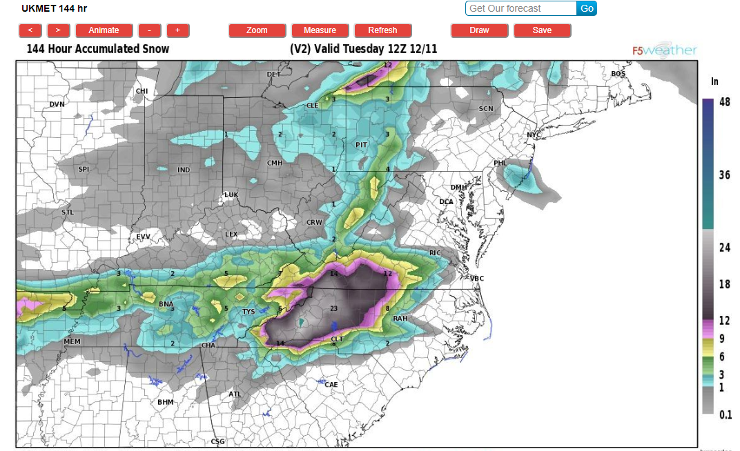
4 minutes ago, UNCCmetgrad said:
Don't get a chance to drop by too often but saw some ask about Euro snow maps from F5Weather. Definitely less with the totals further east where there will likely be more mixing issues. Also am attaching UKMET snow which is a more robust with the snow further east. Also UKMET is a severe ice storm for NEGA, Upstate of SC, and NC in the southern and eastern piedmont. Show over 1" of qpf falling as FZRA in Charlotte.
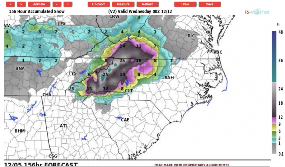

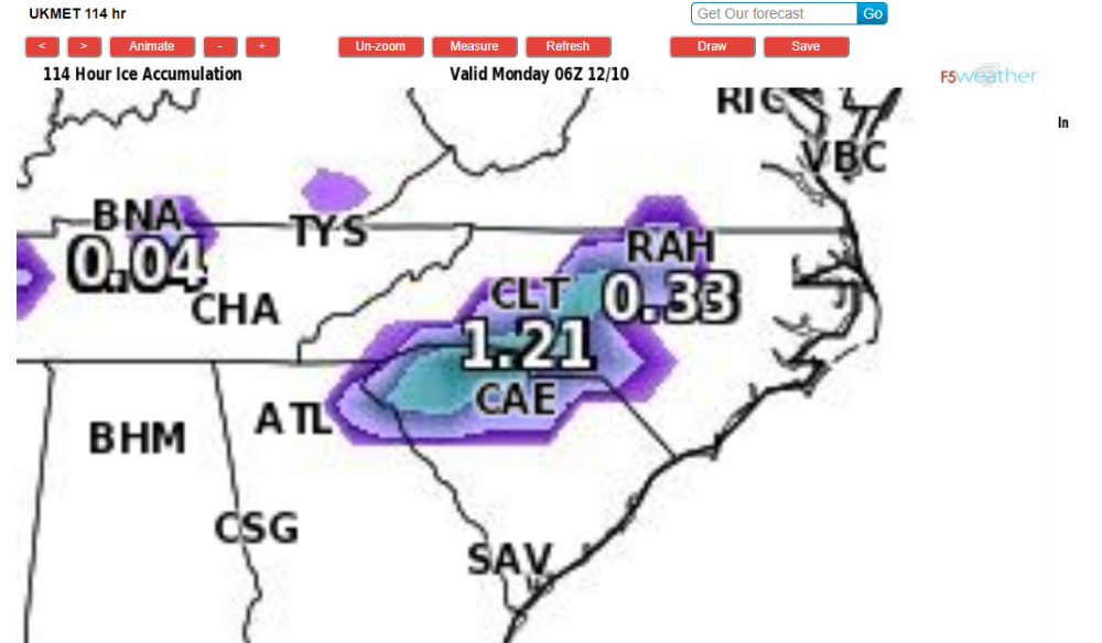
If I remember right the UKMET runs warm on wedge events at this range so odds are you can pull that ice further southwest if that solution verified
-
4 minutes ago, Lookout said:
after a ho hum run this morning, this run is pretty scary looking for northeast ga in terms of ice potential. 925mb temps plummet by sat evening....on the order -4 to 5c... with surface temps dropping below freezing by midnight or so,,,even down to the northeast burbs of atlanta with a lot of precip left to go.
I think there will be major ice down to areas NE of ATL. I’m not sure if it makes it into the Metro at all. Especially given it would have to occur mid way through the event. Most icing events in ATL are from the start of the precip or not at all
-
1
-
-
34 minutes ago, burgertime said:
Well...well...well....but big caveat here this is all dependent on enough cold air for snow. If you believe Euro at face value this would be raging ZR/IP storm.
The bigger concern would probably be that ATL might be in bigger trouble than anyone initially thought. The fact the Euro wants to push snow that far into Georgia gives me doubts that freezing temps don’t reach down there. Right now not one forecasting outlet is giving more than a remote chance it does
-
4
-
-
The high is too far north for those sorts of totals into GA and SC. That would at best be mostly sleet there. Think January 88. It was a flatter setup than this was or at least a weaker low, later in the season and still most of NRN AL and GA saw sleet. This probably is north of the 12Z Euro in the end but even if that verifies dead on those places south of the TN-Spartanburg line are likely sleet. Atlanta might even be rain
-
1 minute ago, shahroz98 said:
How does Metro Atlanta look in all of this ? Are we sitting out for this one ?
The wedge appears to me to build in way too late for them. I could be wrong but simply looking at timing it seems they’d precipitate for too long prior to the wedging so it would be 35-38 and rain. It’s still very far out though.
-
1
-
-
2 minutes ago, Orangeburgwx said:
Eye seems to be drifting west the last 30 minutes or so
If you didn’t know any better looking at satellite today you’d think Florence had its own mind and deliberately deviated north to get away from the shear and dry air and now said okay I’m resuming course again.
-
1
-
 1
1
-
-
5 minutes ago, Wild Weather Monger said:
Radar filling in rather nicely W and SW of Atlanta.
Correlation coefficient still showing the R/S line more or less straddling interstate...85 I believe from ATL airport down about 20 miles or so but it is pushing ESE
-
1
-
-
3 hours ago, audioguy3107 said:
Still can't get over the HRRR.......has the secondary band pivot right over the Atlanta metro and has us in the snow until close to 11 AM on Saturday morning.....just incredible if it pans out this way.
The Obs over AL in that snow band are not impressive, but the 700-850mb temps in that area such as MGM are not anywhere near as ideal as they will be over the ATL metro. Many places are -1 to -2C at 700 while ATL will be near -7-9C at 09z
-
2
-
-
22 minutes ago, Touchet said:
There is nothing but rain here in Bham. Temps stuck at 35 to 37. But all around us it is snowing. Hate how that happens. I’m following the Rgem. It did a good job last year. I got blocked from span’s website the day before last years when I told him it would ice while he was calling for flurries.
RGEM looks like it changes BHM over at 11Z or so
-
1
-
.png.f52bfc210314ab4f05dce3dd741ef8ff.png)


Memory Lane
in New York City Metro
Posted
I’m not sure if that LE was correct though. It is pretty darn accurate today at Central Park but I don’t believe there was an ASOS there yet then they were using some sort of old school home weather system for readings from October 1993 til July 1996 when I think the ASOS was put in so very possible that reading was erroneous