

SnowGoose69
-
Posts
15,271 -
Joined
-
Last visited
Content Type
Profiles
Blogs
Forums
American Weather
Media Demo
Store
Gallery
Posts posted by SnowGoose69
-
-
2 hours ago, paulythegun said:
For laughs, still checking on the ECMWF Extended. Here are the last two runs showing March 8th 00z. And...shocker... The March 12th/forward pattern it's been advertising keeps moving forward as we get closer.
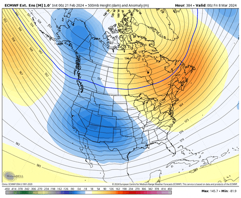
Models always try to rush pattern flips...depending upon what the SSW does though we might find that things change faster than expected. Would not be exactly blown away if the 3/10-3/15 period ends up colder or much different looking at H5 than what ensembles will show over the next 5 days when its falling in the 11-15 span.
-
 1
1
-
-
2 hours ago, Brian5671 said:
dying industry with the average age of the listener increasing every year....ratings way down from their peak in the 1990's....so many other ways to get news/weather now...so the talent level tends to diminish as they cannot pay the bigger figures anymore-same goes for local TV newscasts
There was a pretty strong push from the mid 90s to the mid 2000s to hire mostly degreed meteorologists on TV but in the last 10-15 years that has really vanished again. Many of the people on TWC for example are not meteorologists now...at least the more recent hires anyway. Part of the problem is the Mississippi degree is becoming a huge thing now. I have been hearing even operational meteorology jobs they're seeing like 30% of the applicants with that degree. NWS requirements still force you to have courses though which won't qualify you with that degree
-
 1
1
-
-
2 hours ago, EastonSN+ said:
I honestly do not remember the temp profile of 03/04.
Some similarities to 00-01 though December 03 was not nearly as cold but the winter decided to just take a long break for most of February into early March before it came back again. February 04 remains the only case for NYC where at least 6 inches of snow did not fall when Dec/Jan both had 10 inches or more.
-
2
-
-
17 hours ago, GaWx said:
Indeed. The one exception this winter was in late Dec, when they were still predicting mainly mild for that mid Jan week that was then just over two weeks out and that turned out to be the coldest of the winter. What an odd curve ball that was. Some areas predicted on this map to be +5 for that week ended up -20 instead!
Ensembles have tended to be too strong with any SE ridging most of the winter...the area they've missed has been the PNA ridge which has tended to verify way flatter than shown in the longer range but the tendency to want to show ridging maximized outside of SE Canada or New England has failed on numerous occasions which is why despite being above normal for the winter, places from MS across to GA and into FL have been frigid relative to what they saw in Jan/Feb 2023....I have seen ATL has had only 1 high of 70 or higher the entire winter so far which explains why on web cameras I see the pear trees hae not even bloomed yet where last year as well as 18/19 and even 22 they were basically leafed out by now.
-
3
-
 2
2
-
-
1 hour ago, psuhoffman said:
Unfortunately my research shows there is a lag time wrt fading la nina patters. There is absolutely no evidence that a La Nina that fades towards neutral during the winter produces an increase probability of snow later in winter here. In actuality, the Nina's that fit that category had lower snowfall in Feb/March than La Nina's that did not fade. Snowfall can be a fluke so I also looked at the H5 patterns, and saw no evidence the canonical Pacific La Nina pattern was more likely fade late in winters where the La Nina faded.
I can accept what you are saying about a fading El Nino might be true. Perhaps an el nino patter breaks down faster and there is no lag. But there have been examples of fading el nino's where the canonical nino pac didn't break down until well after the nino SST's did. I would have to look into it more to try to understand the why behind the what.
ETA: Also...there is some evidence that a neutral following a nina is even worse than a nina. So that might explain why a fading nina does us no good.
89-90/96-97/01-02/11-12/12-13 were all relatively bad. I am not sure a neutral after a Nina would be bad but they do tend to be and often times they suck for a large section of the country...01-02, 11-12, 12-13 were pretty much bad in large sectors of the nation.
-
1
-
-
29 minutes ago, RCNYILWX said:
From what I've been told by a former coworker at OKX, the CPK conservancy folks do a better job than the security guards that used to do it. But they're still not trained observers like FAA contract observers and probably still lower quality than good long-running COOP sites and diligent CoCoRaHS observers.
If I were to guess, they too often or mostly adhere only to the 6-hour board clearing and don't take intermediate measurements when the situation (melting and/or sublimation of fallen snow) requires it.
I always wondered how they measured back before 93. I assume they labeled the measurements at CPK but they must have been getting done outside the NWS office at Rockefeller Plaza at the time
-
1
-
-
2 minutes ago, LibertyBell said:
This may be the first time ever JFK will have more snowfall than Boston for the entire season lol.
I thought it 03-04 JFK beat them
-
1
-
-
3 minutes ago, bluewave said:
Boston is doing really poorly so far compared to their total seasonal average and Philly much better.
seasonal snowfall so far vs average seasonal snowfall
Boston….9.7……49.2
Philly…….11.2…..23.1
The airport and downtown has been shafted in every event somehow it seems
-
1
-
-
1 hour ago, bluewave said:
An asterisk will have to go next to the NYC snowfall measurements since they are our only major station still below 10” on the season. Our other major stations are all above 10”. The low snowfall measurements are the winter version of the low high temperatures during the warm season due to the vegetation too close to the ASOS creating deep shade that wasn’t there before the 90s. We generally did the best we could this season with the continuing record warmth and hostile Pacific patterns. While we are on track for another below normal snowfall season, it won’t be as bad a last year.
Seasonal snowfall so far vs the seasonal average
EWR…12.2….31.5
NYC….7.5*….29.8
LGA….10.5….29.8
JFK…..12.8….25.9
ISP…….10.9….31.8
BDR…..15.6….33.6
This is the one event I think they clearly under measured. I could definitely make an argument for what they got in the previous event as EWR/LGA were close
-
1
-
-
2 hours ago, snowman19 said:
@bluewave The signal on the ensembles for an extremely warm last few days of February and especially early March is astounding. I haven’t seen a signal this strong since probably March, 2012
It still appears it won't last long...already ensembles beginning to flip things more +PNA or zonal at the end of their runs minus the GEFS which has been really lousy all winter anyway, we cannot sustain any pattern more than 10-14 days it seems and once again we probably won't here. We'll see if maybe after 3/25 we can flip things consistently mild but I do think we will have a lousy cold dreary stretch mid March.
-
1
-
-
FWIW the GEPS had a much less hostile pattern at the end than the GEFS/EPS did so we'll see if something could still happen in mid March perhaps....I would still expect even if we have a hostile pattern 2/27 to 3/10 it could flip again
-
1
-
2
-
-
5 minutes ago, CPcantmeasuresnow said:
Right about the table top wrong about how often.
Measurements are suppose to be taken immediately after the event is done so compression and melting do not take place and an accurate measurement of the maximum depth of the snow during the event can be assured. This is something they never do at Central Park. That's why they come in low through almost every event. It's pathetic but they rarely address it. The storm four days ago a text book case in point.
Yeah based on EWR and LGA its fairly likely they are like 0.5 too low on this event at least
-
3
-
-
Staten Island might be upgraded to a winter storm warning shortly
-
1
-
-
5 minutes ago, jm1220 said:
We’ll see what happens in PHL. Under a warning but downtown is still at 40 (it will cool quickly when snow starts) and short range models have most snow near Allentown and along I-78.
It sure does look right now relative to 12-18Z models today that the heaviest snows may end up north of that
-
2
-
-
Sure does appear the RGEM/Euro will be best on start times. Places in PA snowing or about to snow the NAM/recent HRRR runs did not have snowing til 05z
-
2
-
-
13 minutes ago, Snowstorms said:
I agree. Perhaps the +AMO is playing a role in driving the SE ridge? The AMO has been positive since the mid 90's and could definitely be enhancing the SE ridge with the warmer Atlantic. Both the PDO/AMO were negative from the late 50s till the late 70's which led to many cold/snowy winters. Although the 80's and early 90's weren't particularly snowy, they featured a lot of cold winters which may have been driven by the -AMO.
A few years back I felt we'd see a flip to a -AMO soon, not so sure now but it should occur in next few years as its been 28-29 years now
-
2
-
-
Just now, Snowstorms said:
I believe that WPAC warm pool may have contributed towards that as @bluewave mentions every so often.
I have to check the 72-73 anomalies at 500 which was more of a -PDO Nino. But I think it resembled as PSU said in the MA forum the classic pattern that used to work for us and even the SRN US but no longer does with the -AO/NAO and -PNA but you did not have the stupid ridging in the SE we always see now in that pattern
-
2
-
-
2 minutes ago, Snowstorms said:
I beg to differ. This winter seems typical of a strong El Nino. It may not finish as a "super" El Nino but it's definitely a strong El Nino, similar to 1972-73 and 1965-66, both of which fell short of super status.
December 2009 was well below average across most of western Canada. Jan 2010 was near average for the southern Prairies and February 2010 finished below as well. Polar opposite of this winter. The "source region" was much colder with a solid snow cover hence it led to more snow for you guys in the Mid Atlantic/East coast as the AO/NAO block suppressed every storm. The block kept all of northern Canada warm but that's normal in a strong blocking pattern. Quite different than this winter where most of Canada will finish above average.
See climate data in the link above. Regina averages -12.4/-14.7/-11.7C, respectively for DJF.
Most strong Ninos feature the raging E Pac vortex which was largely absent this winter
-
Just now, ILoveWinter said:
Temps will be better this time around and the event starts overnight which should help. But can CPK end up being at the lower end again? Sure.
My point is that it's possible CPK ends up with more than the last event.
They'll likely be around 35/14 or so when snow begins...will get down to upper 20s but will be 10:1 or 9:1 for awhile at the start. I'd still lean 2-3 with a shot they get around 3.5 or so but I'd be 30-35% they beat the last storm total...decent odds but would not set it over 50
-
1
-
-
55 minutes ago, Allsnow said:
Looks good for our area. We better not loose this heavy band to sw ct haha
Remember the usual rule, 20-30 miles N of where most models show...most show best banding between around TTN and Toms River roughly so perhaps you focus on Perth Amboy/SI south to about Lakehurt for the best chance of banding here as of now....S shore of Queens/Bklyn/W LI might be able to get in on it with a slight north shift
-
3
-
-
1 minute ago, Krs4Lfe said:
Agreed, this was reminiscent of the 2016 strong El Niño, and other strong El Niños of the past. But this wasn’t a strong El Niño. So why was it so warm? Troubling for sure. Maybe due to the December pac jet extension, which torched December, not allowing snowcover and cold to be established. Same thing happened in early to mid Feb. 2 critical timeframes that we lost due to pac torch. Could that be the reason why ?
Most likely yes, the fact Canada just was stupidly warm...even 09-10 it was not that cold of a winter at all outside of the southern tier of the US...Canada was largely torched that winter too
-
Just now, jm1220 said:
RAP looks really good. High end advisory event for most.
It still tends to have a NW bias at this range so I usually take it S-SE or E somewhat beyond 18 hours...last event it was definitely a bit too far NW but hard to tell since we had fluky subsidence and bands and the models were all over the final day or so
-
I think NYC needs 2.6 to avoid being top 10 least snowy winters...hard to believe when I began doing this 35 years ago #10 was like 12.6 inches lol
-
1
-
-
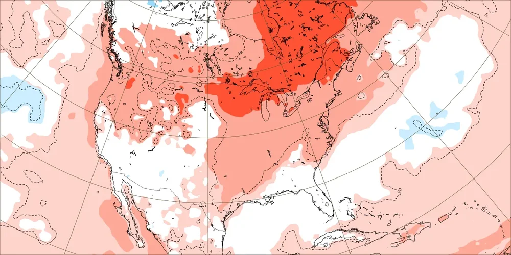
15 minutes ago, Krs4Lfe said:
Ryan Maue posted some maps showing the extent of the warmth across the nation from the pattern flip around March 1st. The EPS and GEFS are the most bullish on this, with temperatures around +8 for the NYC area. GEPS is least bullish, with temperatures around neutral. That being said, all of them indicate a colder than normal (generally -5 to -10) across the west, including UT/NV/ID, and of course the west coast. Should lead to some good snows over there.
Its fairly crazy how mild the winter was basically for the entire nation despite the fact we never really had a true strong El Nino pattern at any point

March 2024 disco/obs
in New England
Posted
Even now why is the GEFS so much more troffy out west near 3/20 vs the GEPS/EPS? Even with the two ensembles close to the same on MJO amplitude in 7? Would see again GEFS just more thinks the PAC jet is gonna blast the PAC NW blocking ridge that forms away while the other 2 suites do not see it being as easy to knock it down