jpeters3
-
Posts
736 -
Joined
-
Last visited
Content Type
Profiles
Blogs
Forums
American Weather
Media Demo
Store
Gallery
Everything posted by jpeters3
-
I actually think it might make a huge difference. The HRRR is blowing a big hole in the low-level instability beneath the region of widespread convection, which is going to put a tamper on discrete updrafts. Furthermore, this sort of convective evolution will limit destabilization further north. While I feel confident that there will be tornadoes somewhere, the 00 UTC HRRR scenario is a show stopper in terms of a historic outbreak. Lets hope this pans out. Given that this earlier convective blowup is consistent with the euro and some of the other CAMS, i'm inclined to believe it moreso than the crazy runs earlier today. It's also (for the most part) more in line with how these events typically evolve in the SEUS.
-
I think it's reasonable to assume that we'll see something *at least on par with* last week in terms of # of tornadoes and coverage. It's hard to imagine that not happening given the more impressive parameter space. So what we all are unsure of is whether it will get even worse than last week's bar. For the record, last week actually had quite a few discrete supercells. They just didn't consistently produce long track tornadoes.
-
I wouldn't lend much credence into these small details. 3 km models cannot properly resolve supercells, much less smaller nonsupercellular updrafts. For reference, supercell updrafts are typically 5-10 km across. Nonsupercells are 1-2 km across. So what the model is portraying on the convective scale is a bastardization of the real atmosphere.
-
This is my guess as to why the NAM nest has less warm sector convection. The warm air does not directly cap things, but could hinder storm growth through entrainment. It's just a guess though.
-
I generally agree that a High risk for tornadoes will probably verify tomorrow. It's almost guaranteed, barring some crazy guidance shift, that tomorrow will have a day 1 high. So the question is, how much worse does it get. As last week showed us, the bar, in terms of tornado outbreaks, is pretty low for a high risk to verify. It can get MUCH MUCH worse.
-
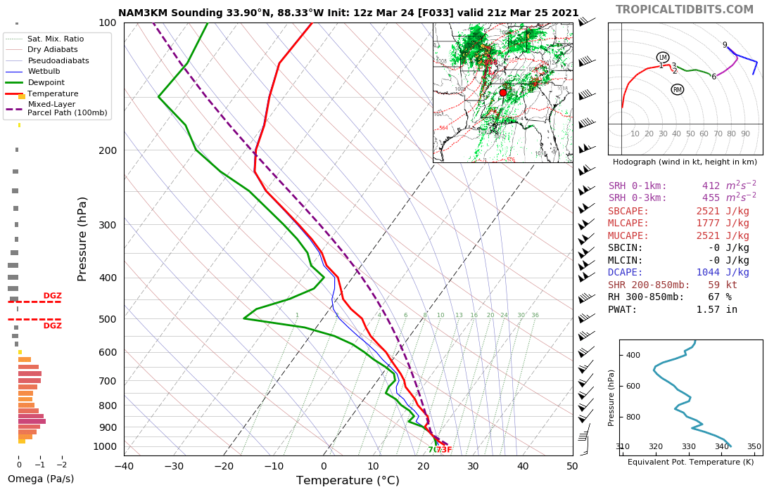
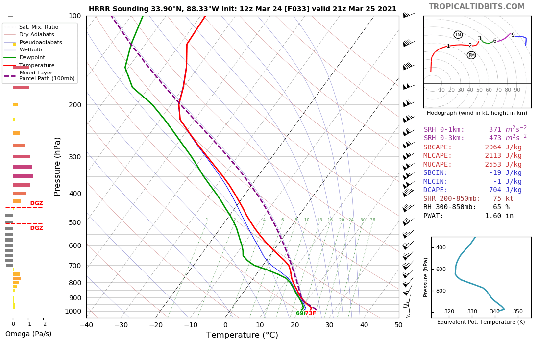
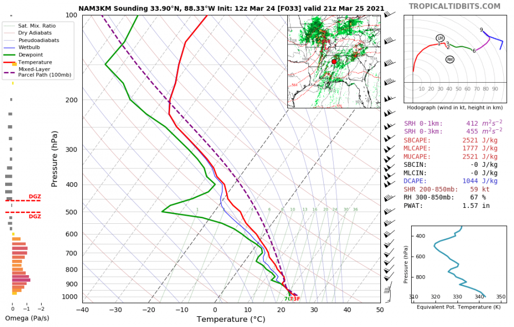
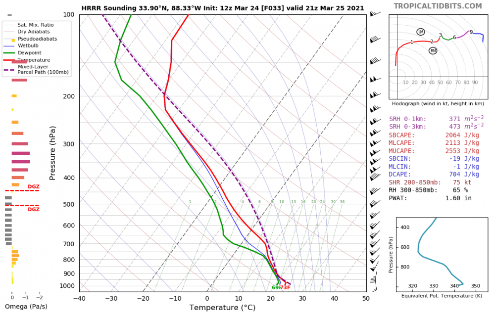
The tropical tidbits soundings are misleading, because they plot parcel and environmental Temperature, rather than Virtual temperature. If they plotted virtual temperature, the low-level CAPE would show up better. For those of you who are unfamiliar with virtual temperature, it is a temperature adjustment to the air that accounts for the affect of moisture on density. Virtual temperature is typically a few C warmer than actual temperature when there is a lot of moisture. And sometimes Virtual temperature of a parcel can be larger than that of the environment, despite the parcel's actual temperature being cooler than that of the environment.
-
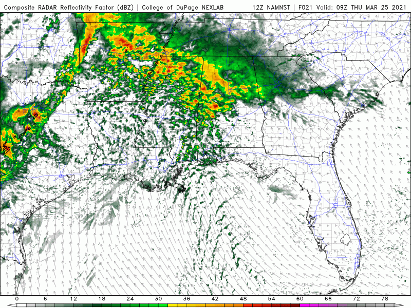
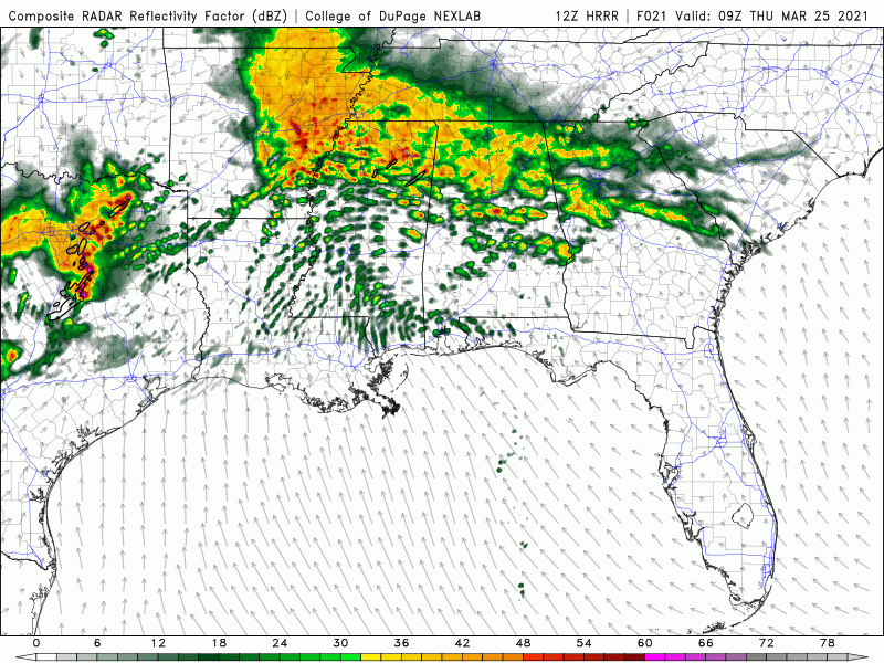
Here's an example: NAM nest HRRR Now the MLCIN differences are basically negligible. However, CIN isn't the entire story. Growing updrafts (i.e., congestus) are very susceptible to the negative effects of entrainment. The dry warm region in the Nam NEST at 850 mb may kill everything that tries to form via dry air entrainment. In contrast, the HRRR shows a much deeper moister layer. In the HRRR situation, growing cumulus can make it deeper, and parcels can gain more momentum, before they start to feel the negative effects of entrainment. This difference is subtle, but these types of subtle differences can make or break an outbreak.
-
This is generally true. And it's fairly simple. Look at the suite of CAMs, and compare the ones that show development to the ones that don't.
-
Yeah, this pretty well sums it up. If I had to bullshit, i'd say: 20% total bust, with fewer tornadoes than last week 60% an outbreak, with at least a few EF3 (+) destructive tornadoes 10% Historic outbreak of the magnitude of 4-12-20, super tuesday, 4-14-12, etc 10% Superoutbreak. Please keep in mind that these numbers are totally pulled out of my ass.
-
Agreed. I suspect that if we did an exhaustive analysis of all the CAM solutions that showed apocalypse like this HRRR run, we'd find that 20% or less of them verified as advertised. Not saying we won't have tornadoes tomorrow, but the chances of an actual super outbreak (or even a sub-super, but historic outbreak) remain relatively small.
-
I honestly don't know. It's basically a coin toss. Lets see how CAM outcomes play out throughout the rest of the day. My gut tells me that prolific tornado outbreaks are always going to be less likely than a "bust" with this kind of spread in CAM solutions, because there are many pathways to a bust and few to a prolific outbreak.
-
Careful, this is starting to sound like 5-19-19 all over again, with the HRRR showing apocalypse and the NAM nest showing a seemingly unbelievable non-outbreak. The model isn't violating the laws of physics - it is showing us a dynamically consistently possibility. In examining some soundings, it looks like there is more warming at ~ 850 hPa in the nam nest that acts as a CAP in the warm sector. Again, eerily similar to the "bust" mechanism on 5-20-19. Obviously these two events are quite synoptically different, but we want to learn a lesson from that event and be careful to too hastily throw away CAM solutions that don't show the apocalypse. Edit: In a probabilistic sense, we've seen the NAM nest solution play out numerous times over the past decades. The HRRR solution, on the other hand, has played out only once (or maybe a handfull of times).
-
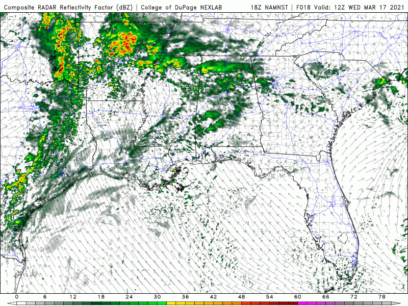
FWIW, NAM nest shows the lower ceiling, with supercells restricted to the frontal line
-
This ^^^^ The 12Z HRRR shows a superoutbreak, no doubt.
-
One thing to note (as was mentioned by @Bob's Burgers), the 00 UTC HRRR run extends the outbreak well up into the MS and OH river valleys. This HRRR run is fairly close to a worst-case super-outbreak esq scenario. However, I am still somewhat skeptical of storm mode throughout the main warm sector in MS/AL, despite the HRRR showing apocalypse. There may be hints in this solution of an ambient messy storm mode, and an upscale evolution akin to 4-12-20. Freaky CAM solutions aside, I still highly doubt a day 2 High will happen, nor do I think it is warranted. Edit: NAM nest shows a similar scenario for MS/AL, and also extends the outbreak a bit further north (albeit not to the extent of the HRRR). One thing to note is both models show fairly quick stabilization into the early morning on Friday, suggesting that a prolific nocturnal event is questionable.
-
This ^^^^^ In general, I don't think issuing day 2 High risks is a good idea. Especially in the SEUS where there is always the inherent uncertainty regarding storm mode. So I would argue that a a day 2 High would be an irresponsible move. Obviously the ceiling on this event is very high. But there is still bust potential, as we have seen in the past with numerous would-be SEUS events. Parameter space is never the entire story.
-
I think that was the original poster's point. A single violent tornado doesn't verify a High risk - many tornadoes do. We've had many tornadoes today, hence high risk verified. I think what a lot of us (myself included) forget is that tornado probabilities in SPC outlooks reflect confidence in a tornado outbreak. They are not direct forecasts of violent tornadoes. A smaller outbreak that verifies a high risk, and that will confidently occur, warrants a 45% tornado threat. Another larger outbreak, but with greater uncertainty from the forecasting perspective, might warrant 15% or 30%. Just because the second outbreak was bigger than the first doesn't mean the forecast was wrong - it just means that there was more uncertainty leading up to the big outbreak, compared to the smaller outbreak. We've likely had a several long tracked strong tornadoes today which fits well well with the forecast. In other words, tornado % (i.e, 15%, 30%, 45%, 60%) in the forecast doesn't necessarily correlate with outbreak size. It correlates with confidence leading up to the outbreak.
-
FYI, John Humphress just witnessed the touchdown of what may be a very large tornado
-
It usually isn't a very good sign, yes...
-
Lol, yeah I have not seen any direct comparisons with 2011. But I have seen about 1000000 posts condemning (nonexistent) references to 2011. This is what we call a "straw man."
-
Yes, making blanket statements about tornado intensity the day before is unadvisable. Recall that the forecast parameters did not exactly scream EF-5 on 5-22-11 (Joplin) or 5-20-13 (Moore). But it happened.
-
Honestly, 5-20 is still a bit of a head scratcher for me. I understand the issue with large scale lift, but large scale lift doesn't trigger convection. It simply makes the environment more favorable by steepening lapse rates and potentially reducing CIN. An interesting result that trending in recent research is that, for CI to really go, you need wide enough sub-cloud updrafts. Because entrainment-driven dilution of updrafts scales inversely with updraft width, wider updrafts can go deeper because they are less hindered by entrainment. In the absence of other forcing mechanisms (like OFBs, terrain, front, dryline), the size of sub-cloud updrafts scales with the PBL depth. In the case of 5-20, the PBL was < 1 km deep, whereas the "threshold" sub-cloud updraft width for making sustained deep updrafts is generally larger than 1 km (in radius). So my hypothesis is that the PBL convection just couldn't cut it on that day. I have meant to write a paper on this, but i never seem to have the time. I wonder if a similar issue will come to play here.
-
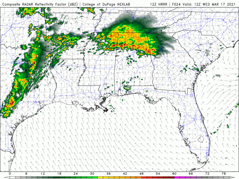
In looking at the 12z (I hadn't before), they do look more favorable for discrete storms. For reference, here is the 12Z HRRR. This looks quite a bit more "outbreakish"
-
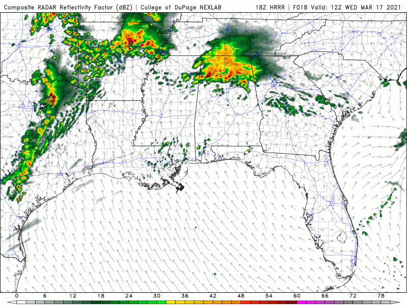
I wouldn't call this bearish on a cleaner evolution. The lack cohesive of UH tracks in the warm sector suggests shallower (than supercells), nonsteady convection. NAM nest, for reference, is quite similar:
-
I'm not arguing against a significant severe event. Given the volatility of the environment, QLCS tornadoes, and perhaps some isolated supercell tornadoes, are likely if the current CAMs play out. But they aren't showing a classic tornado outbreak by any means. An issue in these types of events is that there is no forcing mechanism that generates sub-cloud updrafts that are wide enough to make supercells in the warm sector. So everything that forms in the warm sector forms from smaller boundary layer thermals, and ends up being shallow and grungy. This was probably an issue on 5-20-19.