

jpeters3
-
Posts
736 -
Joined
-
Last visited
Content Type
Profiles
Blogs
Forums
American Weather
Media Demo
Store
Gallery
Posts posted by jpeters3
-
-
2 minutes ago, Superstorm93 said:
Recon is inbound and will likely catch the western eyewall. I was dead wrong about intensity last night, so I'll sit this one out.
To be fair, few of us really expected this level of intensity today...
-
 8
8
-
-
2 minutes ago, Superstorm93 said:
Stupid amount of lightning in the northern eyewall
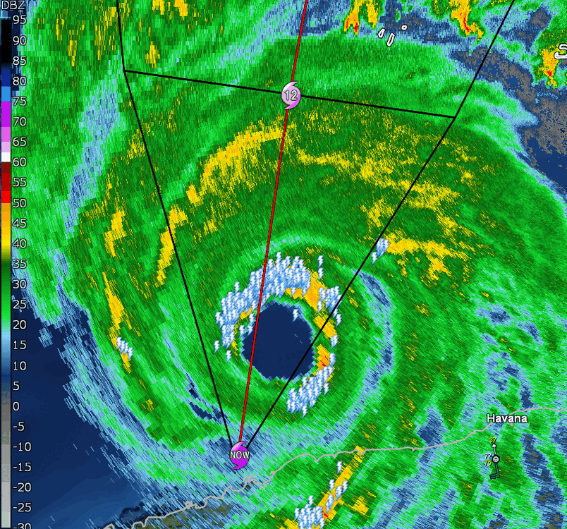
This makes me think we are starting to see the effects of increasing southerly shear, which is arguably visibly evident in the visible loop to the south of the storm. Shear will make the inner eyewall lopsided and can "supercharge" the eyewall convection on the downshear flank a bit.
-
3
-
-
7 minutes ago, jpeters3 said:
I noticed this too. I think it's subsidence occurring radially inward from the strengthening outer band on the south side. Perhaps the beginnings of the formation of concentric eyewalls.
Yeah, i think the recon will shed some light on this feature. it's also possible that the moat is a relic of the land interaction, as an earlier poster suggested.
-
1 minute ago, MattPetrulli said:
Little bit of a moat after the southern eyewall. Thinking maybe a little dry air? Everyone free to chime in of course
I noticed this too. I think it's subsidence occurring radially inward from the strengthening outer band on the south side. Perhaps the beginnings of the formation of concentric eyewalls.
-
2 minutes ago, Powerball said:
It seems the problem is that dewpoints are now starting to mix out. They've fallen into the mid 60s here.
I doubt this will have much of an effect on things. The really shallow high Td layer near the surface would "mix out" anyway as air parcels ascend through the boundary layer into updrafts. What really matters is the average PBL moisture.
-
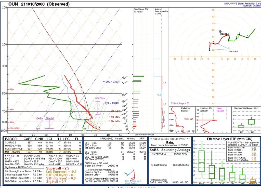
15 minutes ago, OhioWX said:
Special 20z OUN sounding. Once that cap erodes...
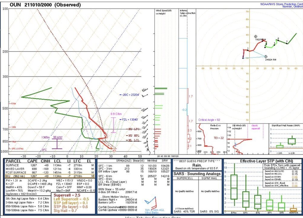
A lot to erode in that sounding. Particularly, -170 J/kg of MLCIN is pretty prohibitive. This is quite a bit higher that CAM progs at the same time. I suspect we might have trouble getting CI anywhere away from the front/triple point.
-
2
-
-
On 9/26/2021 at 3:58 PM, OSUmetstud said:
It might be a 5 now. But it was stronger a few hours before the ERC started. Maybe they'll find it on the next pass.
FWIW, a TC expert whom I trust told me that the available information *does* suggest cat 5 intensity, and that an upgrade in post-storm analysis is likely. So you were correct, and I was wrong. Just thought I owed it to you to share that information.
-
9
-
-
Just now, OSUmetstud said:
I believe it was a cat 5 yes. The only evidence we are ever going to have is the satellite degradation in the past few hours before recon and the pressure. Because there's nothing else. So either they think that's enough or they don't in best track. And that's fine. I'm making a case. You don't have to like what I'm presenting. But you actually suggested there's no evidence. That's not true either. You just don't think the evidence im presenting is strong enough.
You're right. Saying "there is no evidence" was incorrect. There is *scant* evidence.
-
1 minute ago, OSUmetstud said:
We all know it was a cat 5 was a tongue in cheek line, you're taking it too seriously lol.
That's quite the argument you put forward to support a tongue and cheek line.
For the record, I want it to have been cat 5. Just tryin' to keep it real.-
1
-
-
1 minute ago, OSUmetstud said:
Well this is your opinion and that's fine. The degradation in satellite presentation is literally an objective measure. It's almost fallen a full T number in the past 5 hours.
They could still upgrade in best track.
And an upgrade in best track isn't going to happen without clear evidence.
-
1
-
-
Could it have been cat 5? Yes. But is there obvious evidence pointing to cat 5 intensity? No. Ad-hoc arguments about pressure falls don't constitute obvious evidence.
-
1
-
-
9 minutes ago, OSUmetstud said:
so ****ing what?
All intensity estimates are subjective. It's total gaslighting to suggest the pressure drop of 15mb from yesterday along with a degraded satellite intensity over the past 3-5 hours isn't at least some evidence that it was stronger a few hours ago before the plane arrived.
This is not enough evidence to warrant a cat 5 upgrade, and not enough to say "we all know it was cat 5." We don't, and the objective evidence suggests to the contrary.
What would be enough evidence? ADT number near or above 140 kt + flight-level winds high enough + SFMR >> 140 kt. We didn't get that. No cat 5. Sorry. You can wishcast all you want, but that doesn't change things.Obviously NHC experts agree.
-
1
-
-
Just now, OSUmetstud said:
929mb on the sonde when the damn thing has dropped almost a full T number in objective dvorak in the past 5 hours lol.
I know it aint much but there's something here:
223300 1425N 05051W 6958 03062 9910 +109 +100 013066 070 068 005 00
223330 1425N 05049W 6953 03048 9887 +109 +102 012072 073 070 004 00
223400 1425N 05047W 6957 03024 9850 +124 +093 012074 076 072 003 00
223430 1425N 05045W 6950 03004 9817 +124 +091 012081 082 074 006 00
223500 1425N 05043W 6935 02973 9736 +153 +086 010091 094 066 029 00
223530 1425N 05041W 6951 02900 9693 +134 +103 011112 119 111 077 00
223600 1425N 05039W 6978 02772 9607 +119 +133 359107 117 121 071 01
223630 1425N 05037W 6984 02647 9423 +183 +135 345067 096 134 035 00
All you did was repost a twitter post where someone is also hand waving. Eyeballing the wind-pressure relationship in this plot (which shows substantial scatter for a given pressure), an argument could be made for anywhere between 130-130 kt.
-
1
-
-
8 minutes ago, OSUmetstud said:
This is just objectively not true.
Multiple SFMR readings of Cat 5 surface winds via recon yesterday
Dropsonde yesterday supported Cat 5 intensity
The satellite intensity has obviously degraded over the last few hours before recon entered
The pressure dropped 15 mb since yesterday's recon (~929 mb) and now there's a double wind max, suggesting that intensity peaked before they entered.
You are objectively out to lunch. SFMR has a known high bias and readings were inconsistent with flight level winds. Dropsonde probably hit a gust/meso-vortex. There is no double wind max. Intensity is not based on single measurements - it's based on multiple measurements telling the same story. And Pressure vs wind is not linear. Also, winds are up from the higher pressure yesterday. Sorry.
It's just silly when you all think you are smarter than the NHC forecasters. Why would the arbitrarily low-ball the intensity?-
 1
1
-
 1
1
-
-
6 minutes ago, SnowLover22 said:
What is this then?

That's the eye dude.
-
4
-
-
Also, recon did not find a secondary wind maxima, which suggest that the current intensity fluctuation is not the onset of an ERC.
-
1
-
 1
1
-
-
Literally no evidence to suggest that this made cat 5 intensity. ADT peaked at 130 kt (consistent with NHC CI). Pressure is more typical of cat 4. And no, they are not going to upgrade it in a post storm analysis with 0 evidence.
I should add, ADT was remarkably consistent with what the recon found yesterday.
-
1
-
2
-
-
1 minute ago, Amped said:
Hurricane Charlie basically.
My thoughts exactly. Probably 942/130 kt.
I'm guessing based on the satellite presentation that the intensity peak occurred a few hours before the recon arrival.
-
1
-
-
FWIW, ADT is now up to 6.1 (Raw to 6.4), which supports ~115-125 kts. So I'd guess 120 kt, 140 mph for current intensity.
-
2
-
-
4 minutes ago, Amped said:
Yes I'm using weather nerds, cyclonicWX and COD
Thanks. I never thought to look for recon data on these sites.
-
Anyone else having trouble getting onto Tropical Tidbits? Any other sits with good real-time recon data?
-
3
-
-
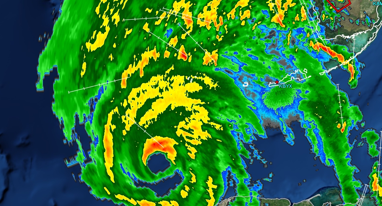
Latest few MW scans suggest that a concentric eyewall structure is trying to form:


-
3
-
-
12 hours ago, TheDreamTraveler said:
Isn't this guy the same guy who was arguing nonstop about radar attenuation during a hurricane last year and it took up pages of the storm discussion right before landfall because he apparently wasn't right or something? lol
Yes ;-)
-
15 minutes ago, HillsdaleMIWeather said:
This is the same person who also just posted that the western eyewall was weakening not realizing it was just radarscope having an issue
Que in the parade of weenies that try arguing that every asymmetric eyewall is due to radar issues. Do we have to go through this every time?
Yes, even intense TCs will have eyewall asymmetry. Pretty dead giveaway that its not a radar issues when it shows up from every radar site, and the weakness is on the upshear side of the storm. It does look like the weakness has become more pronounced in the last hour.
-
4
-

Hurricane Ian
in Tropical Headquarters
Posted
Directly from the AMS glossary:
https://www.nhc.noaa.gov/aboutgloss.shtml