wdrag
-
Posts
5,603 -
Joined
-
Last visited
Content Type
Profiles
Blogs
Forums
American Weather
Media Demo
Store
Gallery
Everything posted by wdrag
-
July 2025 Discussion-OBS - seasonable summer variability
wdrag replied to wdrag's topic in New York City Metro
Ok I'll go there... and drop it from here. I didnt get that warm sense from a post on MAP group. -
Thanks for this Don--- hoping they update this better reality by Noon today. Clearly more than 5" fell. Response is pretty severe in parts of NYC subforum.
-
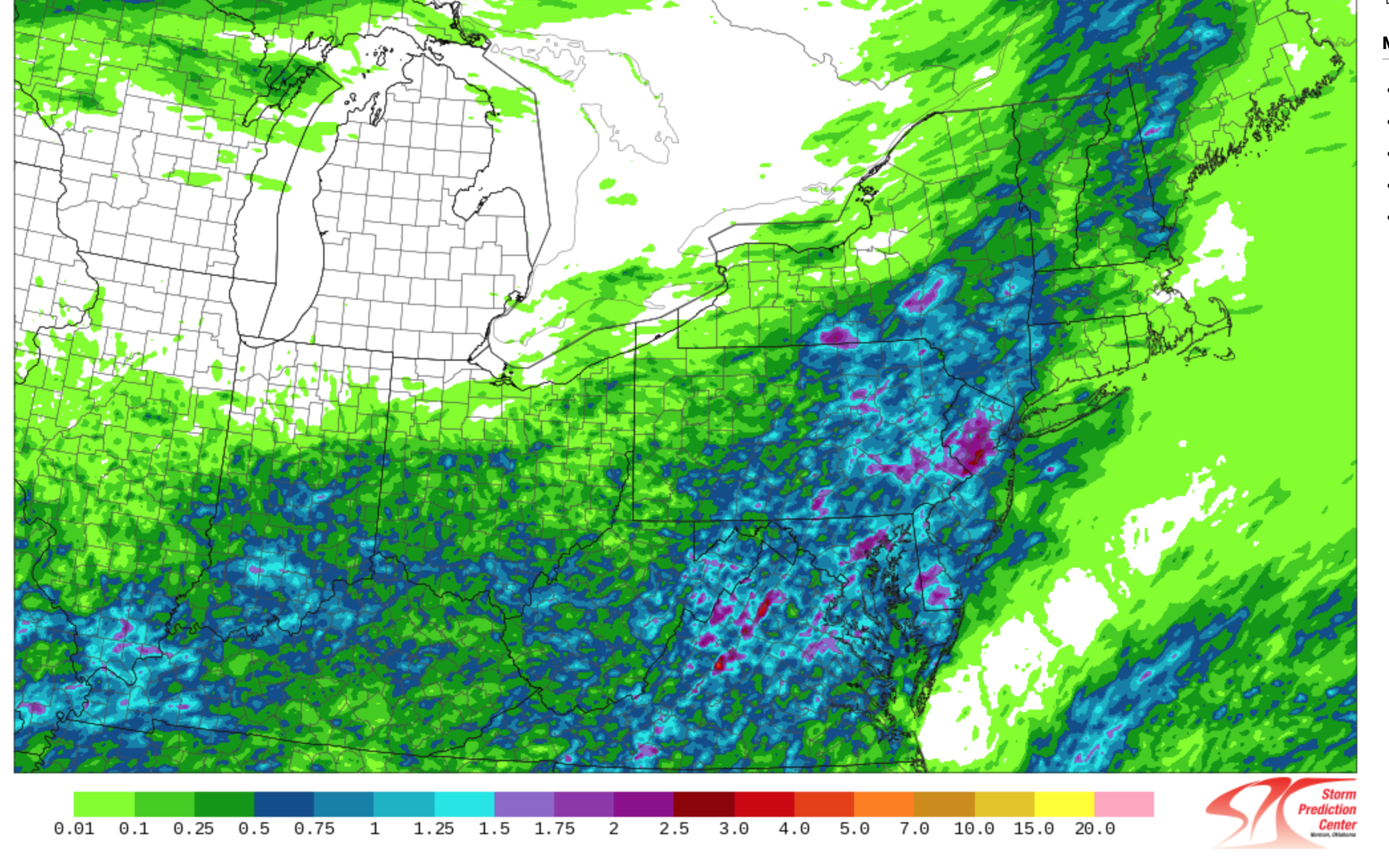
0.82 here i9n this part of Wantage NJ. I'll be looking for a listing of NWS posted rainfall amounts from OKX and PHI on this thread later today. Can't do CoCoRaHs post till this afternoon. am looking at probably one more FF/SVR thread this week centered on Sunday into early Monday. Small chc thread for Wed afternoon-Thu but am pretty sure we'll need a thread for Sunday, in part due to antecedent pockets of saturated turf.
-
July 2025 Discussion-OBS - seasonable summer variability
wdrag replied to wdrag's topic in New York City Metro
You may want to monitor a potential marine heatwave in the north Pacific and discussion of its subsequent winter impact in the northeast USA. Long ranging is fraught with poor performance but the researchers and pattern relators attempt to Improve -
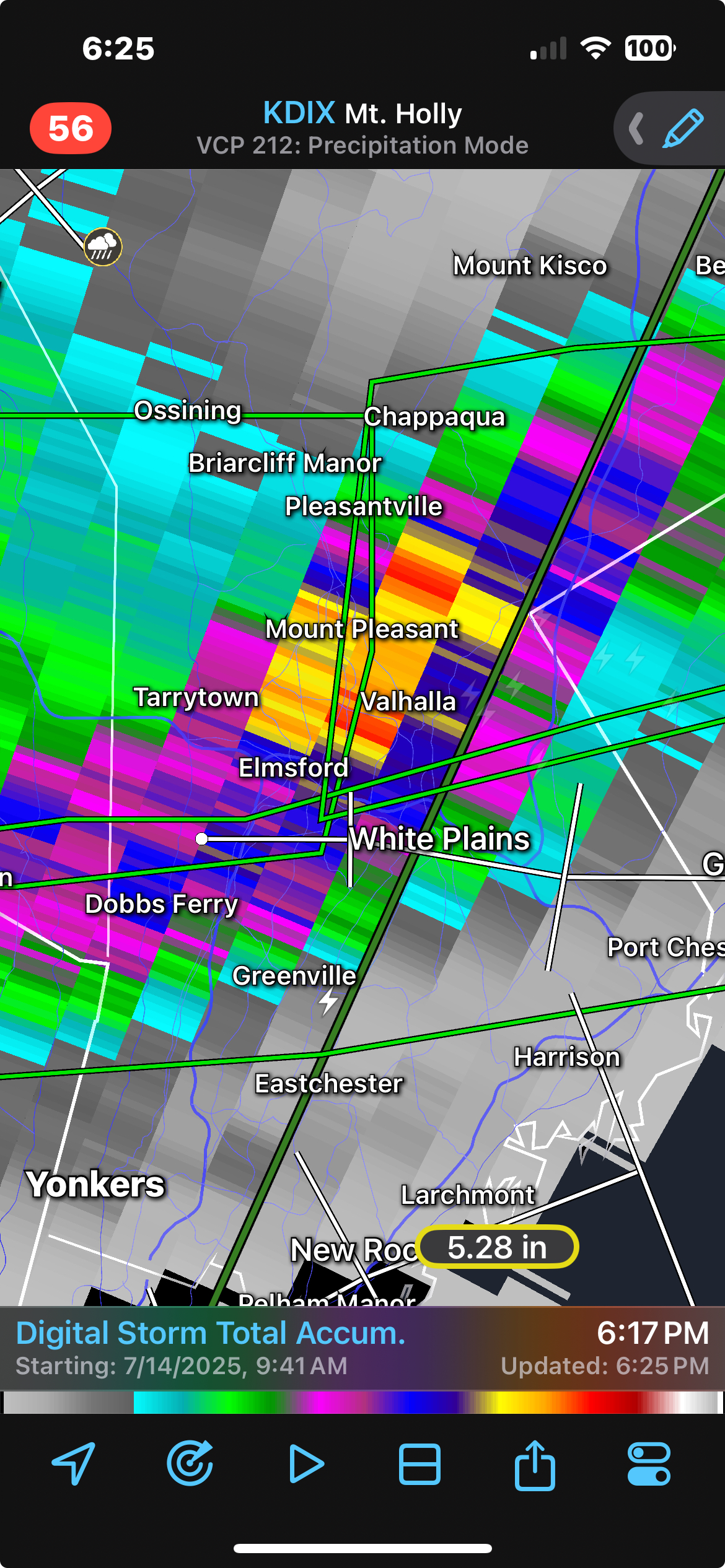
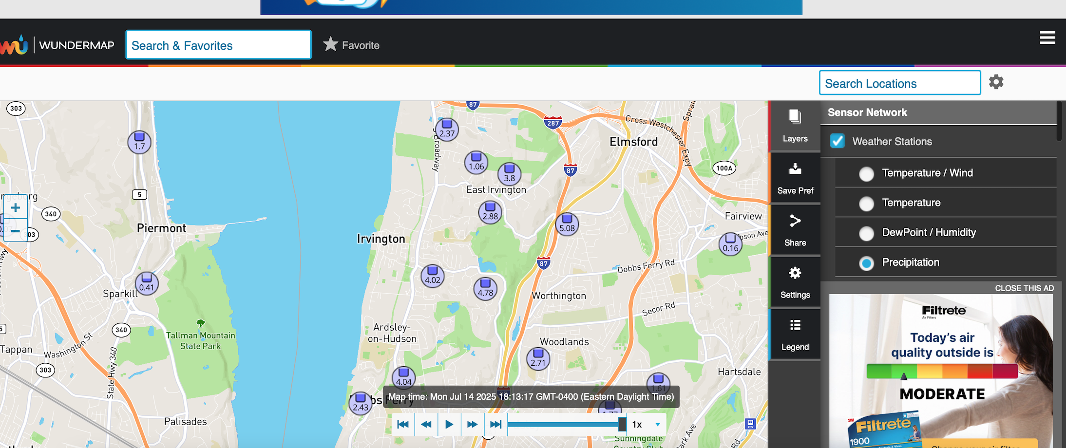
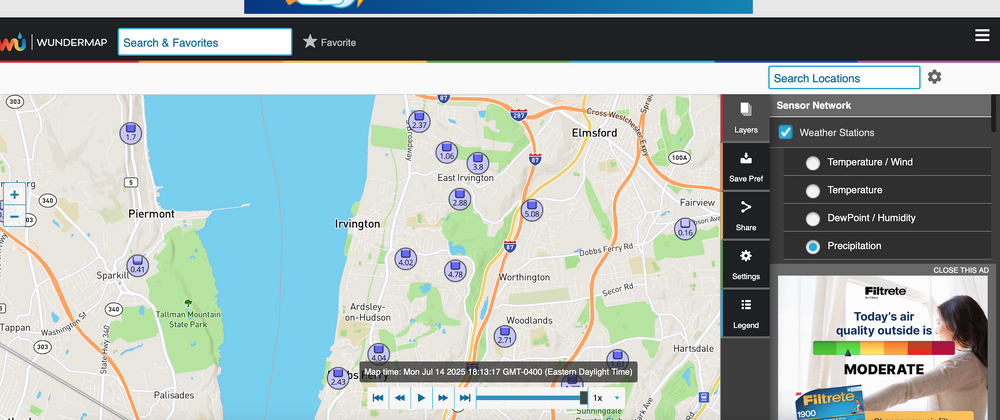
Looks quite threatening from near White Plains into ne NJ. Here's a 5" report embedded within 4" near White Plains. I know NWS doesn't use these amounts but if you check the RadarScope STP...its AT LEAST 5" in that area near White Plains. Just an example. Click for. clarity on both graphics. I'm probably off line til 830P.

-
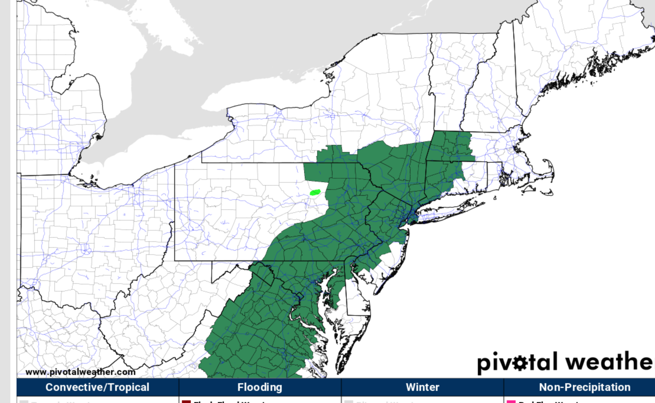
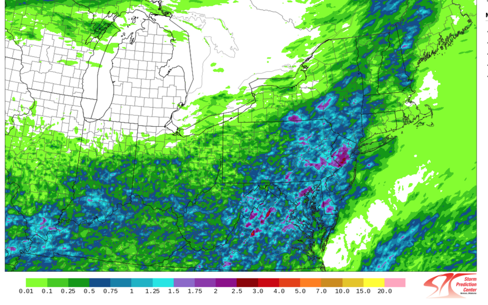
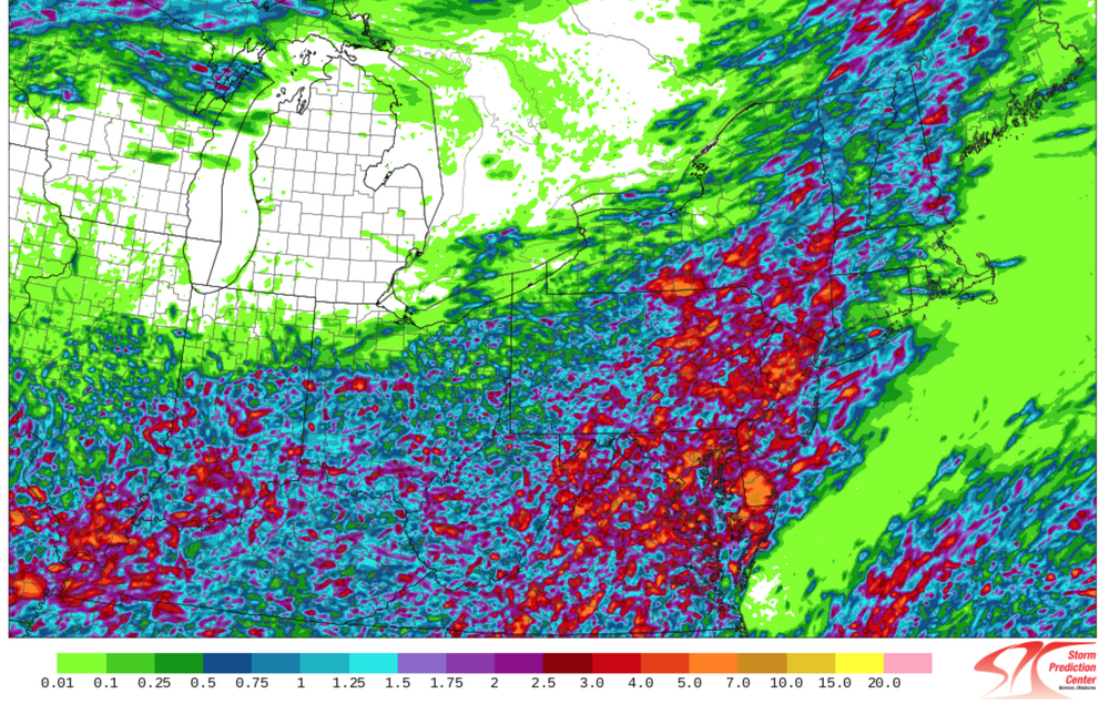
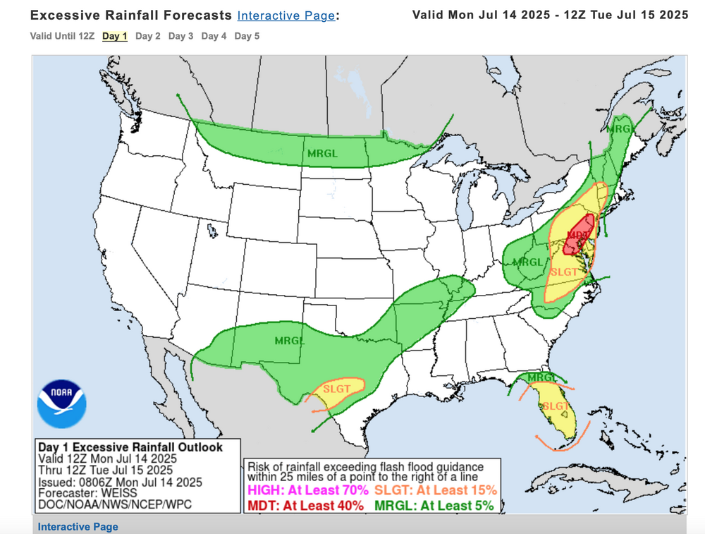
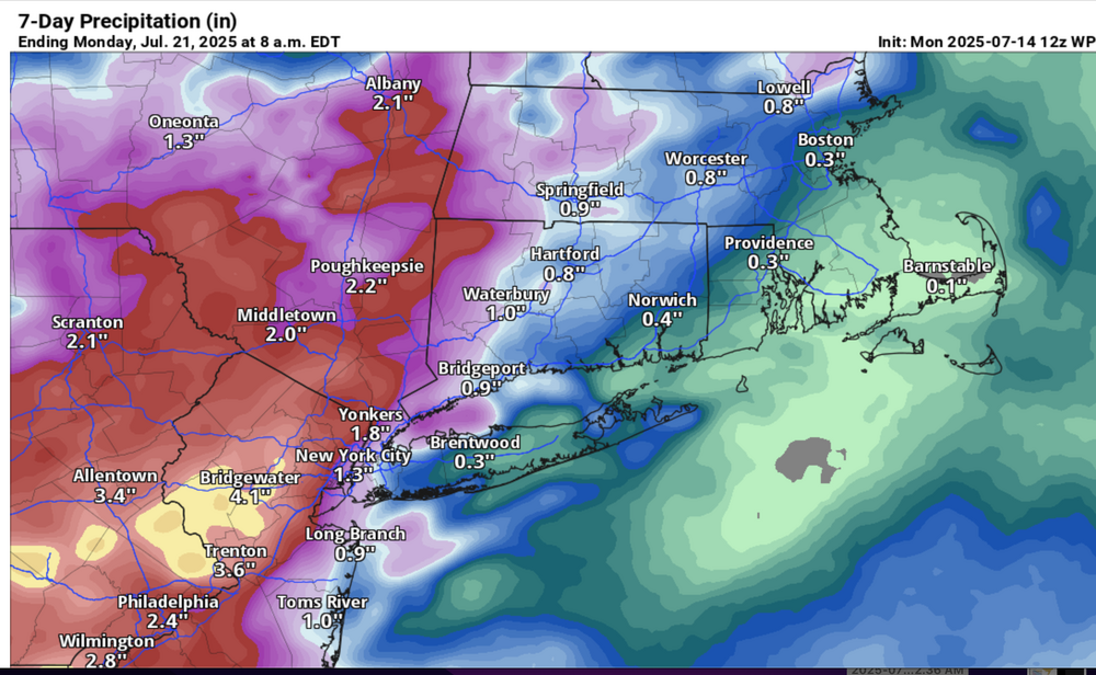
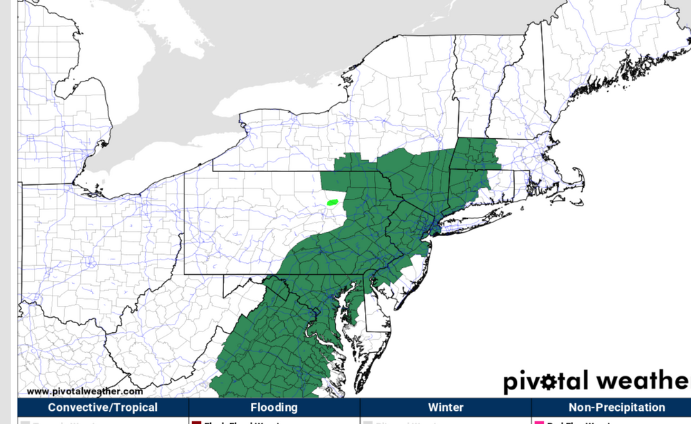
Good Monday morning everyone. Please follow anticipated NWS warnings-statements later today. Already as of 530AM 1/4-1/2" amounts fell earlier today in NNJ. Watches are posted where potential exists for localized excessive rainfall by Tuesday morning, isolated 5-6" totals possible, mainly NJ portion of our NYC subforum. An impaired Monday evening commute is anticipated with delays-accidents-possible detours. Plan accordingly. Recent humid but no rain scenario of past several days limits any mainstream flood potential but creeks-small streams, and especially urban areas along I95 are vulnerable to short fuse excessive rainfall, life threatening flooding if caught in overflowed roads. Turn around-don't drown should be in the back of all motorists minds. Added SPC HREF average rainfall and maximum potential rainfall graphic by Tuesday evening (most of this occurring 2PM-Midnight today). The WPC excessive rainfall forecast. Also the 5AM WPC 7 day rainfall anticipated by the 21st and depiction of NWS watches lager today.
-
July 2025 Discussion-OBS - seasonable summer variability
wdrag replied to wdrag's topic in New York City Metro
No thread as of 609P/13 but since PHI has a Flood Watch posted..am leaning to an issuance as an OBS-NOW FF thread at 6A Monday... all of the above pertains. Will also look and see if I need to combine the wfront/qstry front additional for Tuesday. Have a good night. -
July 2025 Discussion-OBS - seasonable summer variability
wdrag replied to wdrag's topic in New York City Metro
No thread yet, but considering on for I95 corridor northwest across NNJ and se NYS for iso 5" in 3-6 hours Mon afternoon-Night. Will review more guidance late in the day and repost around 8P. 12z/13 SPC HREF is more or less mirroring the heavier GFS qpf. Am pretty sure the iso ~ 5" occurs but where?. -
July 2025 Discussion-OBS - seasonable summer variability
wdrag replied to wdrag's topic in New York City Metro
Wantage NJ 4sw... (8 s of High Point NJ) 347 PM report. Had about .36" in 11 minutes ending around 333 PM. Max G 25 MPH (higher than the previous 140PM warned storm). Very little T if any in this 323PM batch. Total for this afternoon now1.21", one tenth inch less than the automated Ambient gage. -
July 2025 Discussion-OBS - seasonable summer variability
wdrag replied to wdrag's topic in New York City Metro
Wantage NJ 1230-145P including the warned storm. Max G on my weather Stn 14... rainfall 0.85" in 75 minutes - 3 events. -
July 2025 Discussion-OBS - seasonable summer variability
wdrag replied to wdrag's topic in New York City Metro
Thought about a combined SVR-FF thread but HREF not as impressive with max qpf as prior threaded event. No doubt there will be iso 2-3" problems. Noted SPC conservative on SVR so for now...opted to leave all obs right here in the July thread. Will be offline most of the day. -
July 2025 Discussion-OBS - seasonable summer variability
wdrag replied to wdrag's topic in New York City Metro
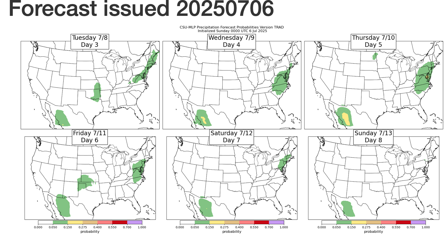
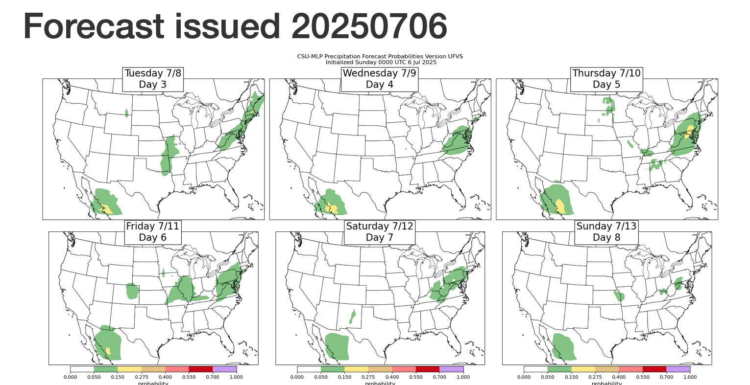
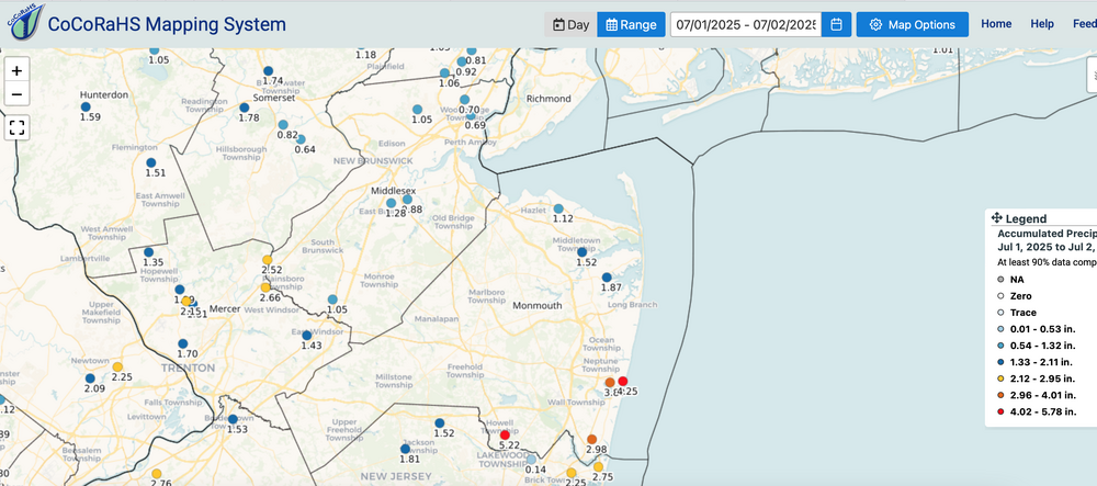
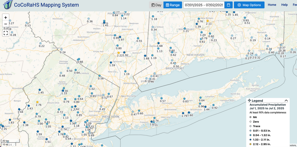
No thread, at least not yet... but the week ahead seems like opportunity for mesoscale excesses. Many models disagree with the EPS (and occasionally the CMC suite) ever increasing heavy rain threat for parts of our NNJ portion of the NYC subforum. For now will go with 3" max Mon afternoon-evening somewhere up here-probably near I95. (Chantel 850 flow-moisture advection combined with RRQ of th UL jet over New England) Looking ahead...the CF heavy convection in parts of the area Tue. Then Thu-Fri, maybe Sat... heavy rain potential with southern stream short wave and warm front returning. Some of the experimental modeling has us in small chance iso FF THU-Sat (spot 5"+ this 3 day period). Added July CoCoRaHs totals as a baseline. Click for clarity. Next potential 3 day (dry) haying period around 7/16-19? Cleaned up the FF potential graphics at 752AM

-
July 2025 Discussion-OBS - seasonable summer variability
wdrag replied to wdrag's topic in New York City Metro
So... unless I'm wrong, the pattern for summer is established. Weakness in the southern and eastern USA. Generally at or ABOVE normal temps around here. Next chance for FF opportunity in our NYC subforum seems to be in the July 8-15 time frame THOUGH AI seems to deny. -
July 2025 Discussion-OBS - seasonable summer variability
wdrag replied to wdrag's topic in New York City Metro
Agreed on premise. Too bad we have to be sarcastic and use CP as a cooling center. Powers that be have created the situation and for the diehards (point specific accuracy), not acceptable. -
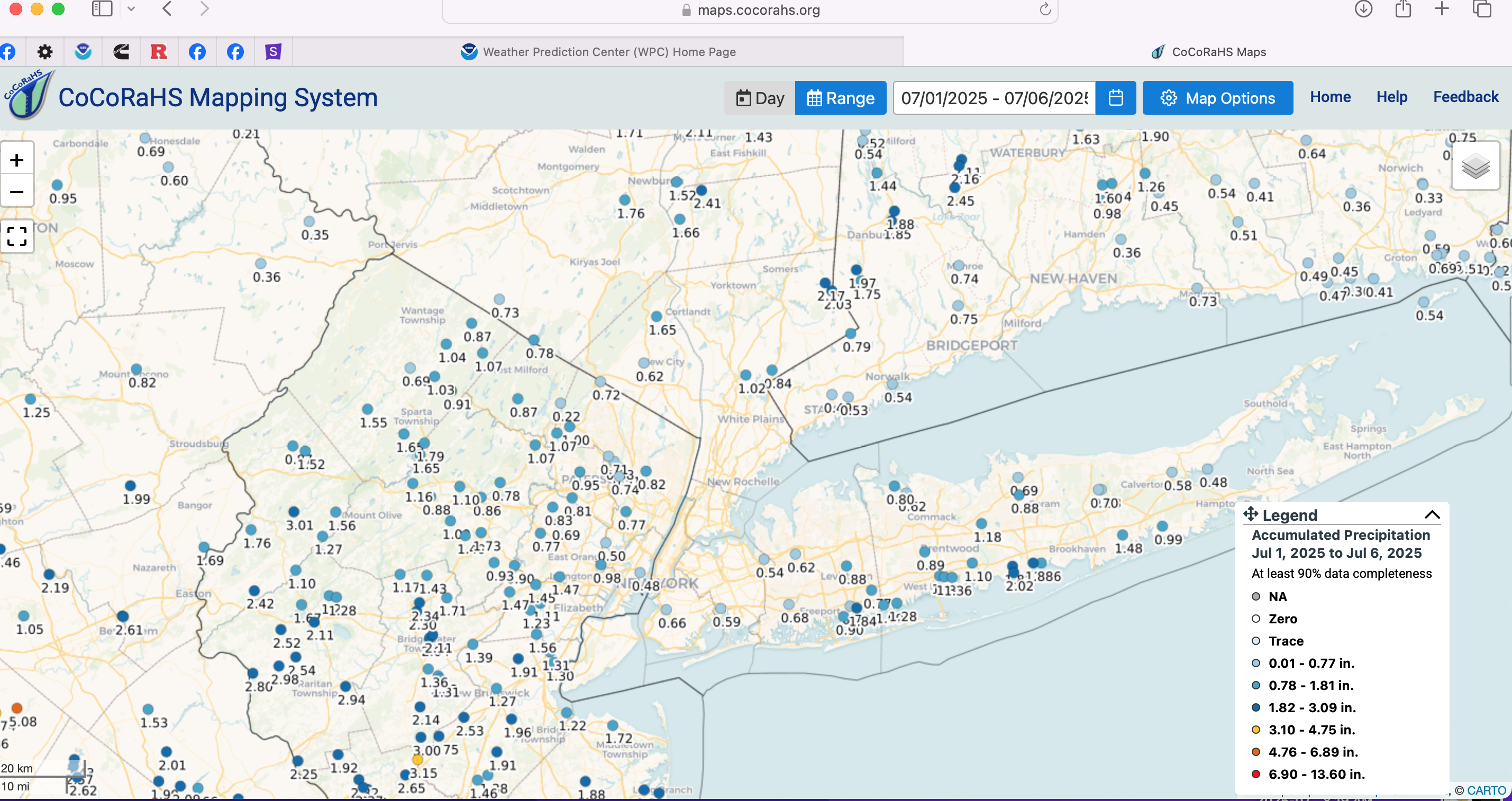
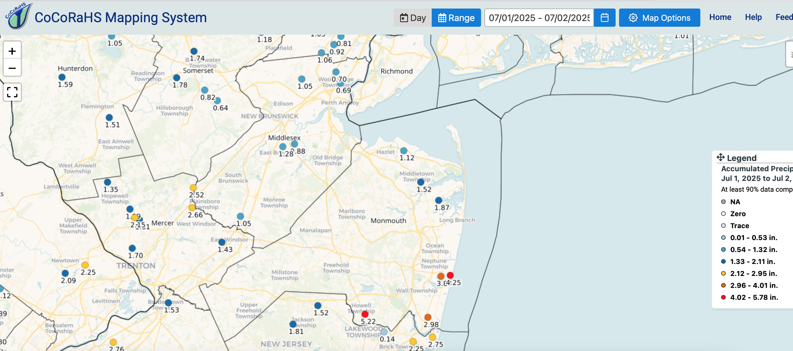
Southern edge of NYC subforum verified 5+. See attached. SVR was reserved for southern edge of our subforum - NJ. Two day totals attached as of 730AM July 2. (You can unpin whenever you want).
-
So far via weather underground 4.36 Asbury park and 4.13 Herbertsville...sough edge of our forum. That's today only. does not include anything last evening.
-
Dissapointing die off near I80 overnight, after 2+ near Trenton and apparently 1-1.5 parts of southeast LI earlier today. This afternoon-night should be active with mesoscale SVR/FF reports. Leftover rain Wed morning LI-NJ. I probably wont be back on til late today.
-
July 2025 Discussion-OBS - seasonable summer variability
wdrag replied to wdrag's topic in New York City Metro
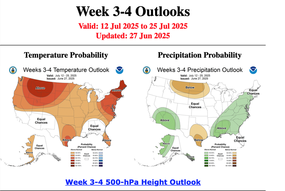
Added CPC July ... issued 6/30
-
Something is bothering me about the constancy of PW over 2" into Wednesday morning, the likelihood 2 - possibly 3 bands of heavy showers and embedded strong thunderstorm passing through our area with plenty of ML Cape over 1200J and 30 kt+ deep layer shear, enough for severe storms, damage, power outages. One band of convection now approaching I78-i80 at 515PM June 30 should weaken soon after sunset. A band of heavy convection should occur predawn Tuesday (Wfront?) with another band redevelopment late Wednesday morning or afternoon (CF). The EC suite differs a bit from HRRR/GFS suite. Now emerging is a 3rd band early Wednesday NJ/LI prior to clearing out the complex frontal boundary out of here. FF and SVR, both mesoscale with some modeling offering isolated 5" amounts in NJ and very low probability, LI, by the time this is done. SPC has us in severe and WPC slight risk FF. If the overnight band is insignificant, then this will likely be a wasted short fuse thread.
-
July 2025 Discussion-OBS - seasonable summer variability
wdrag replied to wdrag's topic in New York City Metro
You'll get yours if we shift into a significant wet tropical season Aug-Sept. No idea on reasoning for a lot of climate variability--- -
July 2025 Discussion-OBS - seasonable summer variability
wdrag replied to wdrag's topic in New York City Metro
Looks temporary and not quite as strong but it will get into the 90s vcnty NYC (INLAND for sure again) at least several days between July 5-10. Seems to shift west after the 10th but part of the variability. -
July 2025 Discussion-OBS - seasonable summer variability
wdrag replied to wdrag's topic in New York City Metro
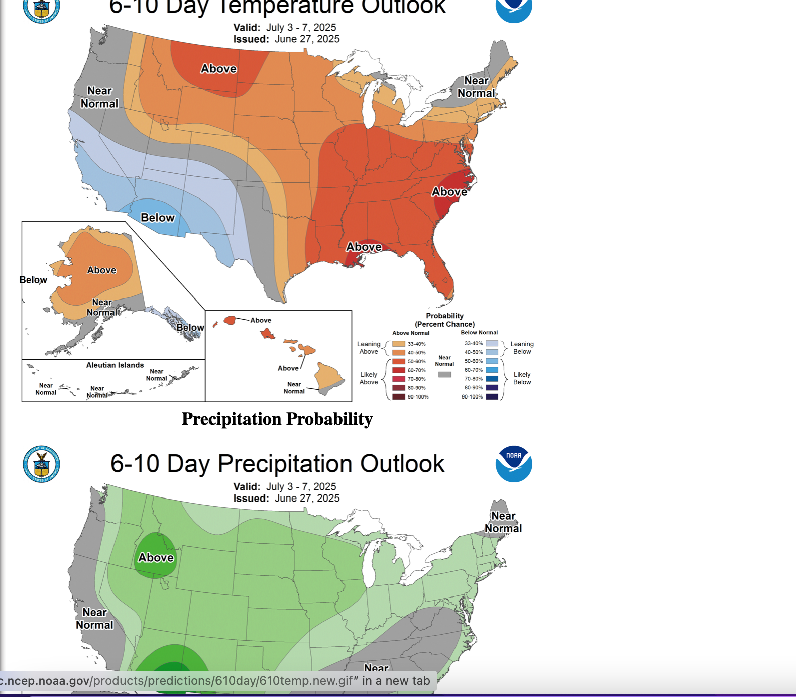
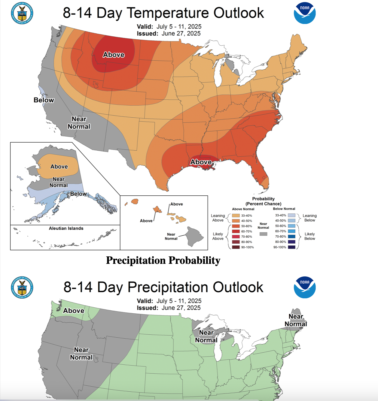
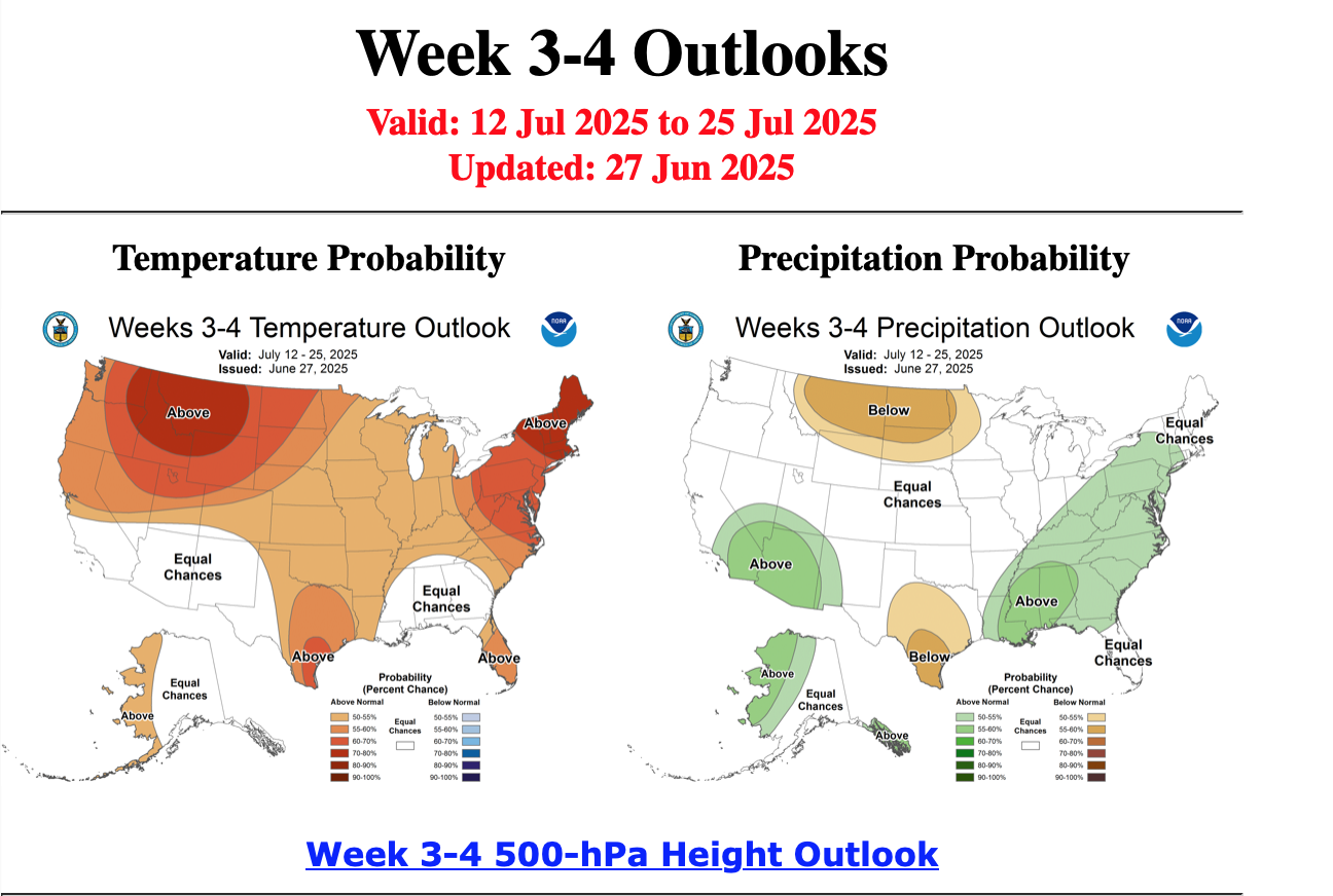
Looks like CPC continues with a warmer than normal July as posted in their 6/19 outlook. Here are some steps in that direction. Their updated monthly should post 6/30. Below from yesterday 6/27 for June periods as listed.

-
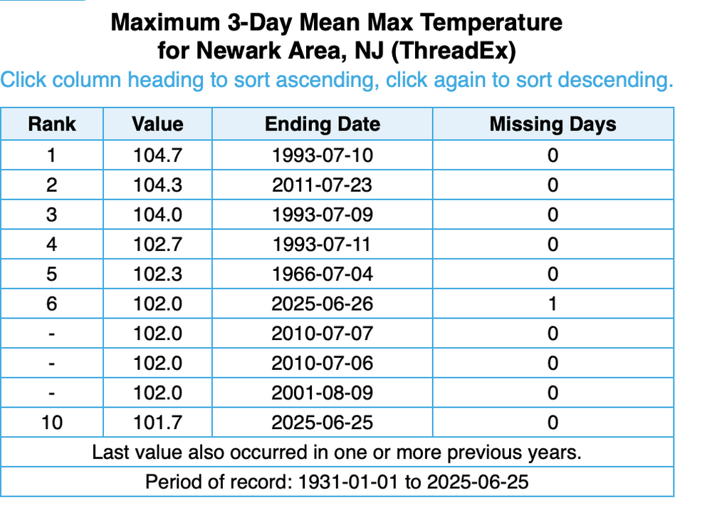
Topping off Bluewave post above: NEVER before have we been able to accurately highlight heatwaves locally 5-7 days in advance. A final from myself (which may have already posted?), this was the 6th warmest 3 day max temp average in Newarks POR dating back to 1931. See attached. I do remember June-July 2010 (see July listing in the attached) when I'd transferred to Mt Holly... a brutal summer start as I recall. Not expecting a repeat this summer but these heat wave excesses are not well modeled beyond 10 days, so cant be absolutely sure we've seen our worst but Bluewave has it right on the excesses earlier. Have a good day and now enjoy a reasonable summer with local excesses.
-
July 2025 Discussion-OBS - seasonable summer variability
wdrag posted a topic in New York City Metro
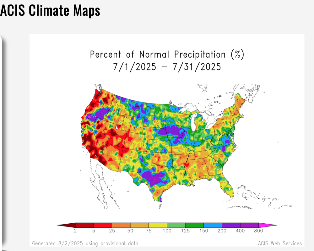
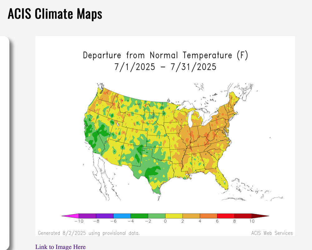
Summer variability as outlooked 6/24... nothing outrageous outlooked as the ridge locks in near the Rockies with troughing in the east. Implies brief hot incursions with frontal passages seemingly progressive. Heaviest rain axis continues outlooked Appalachians to the Mississippi -Ohio Valley. Modeling doesn't pick up excesses very well beyond 10 days. Guidance suggests a warmer than normal month in our area. 6/30. added CPC 1 mo outlook. And the verification for July is beneath...added 8/3/25 650AM. Note CPC did well on temps for August.... but the fickle nature of summer convection s difficult to criticize... Positive to CPC for recognizing the above normal qpf Appalachians.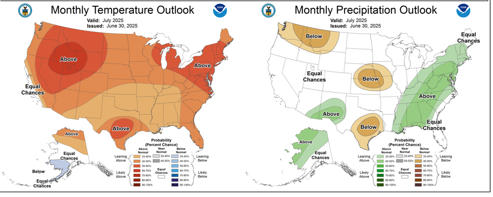
-
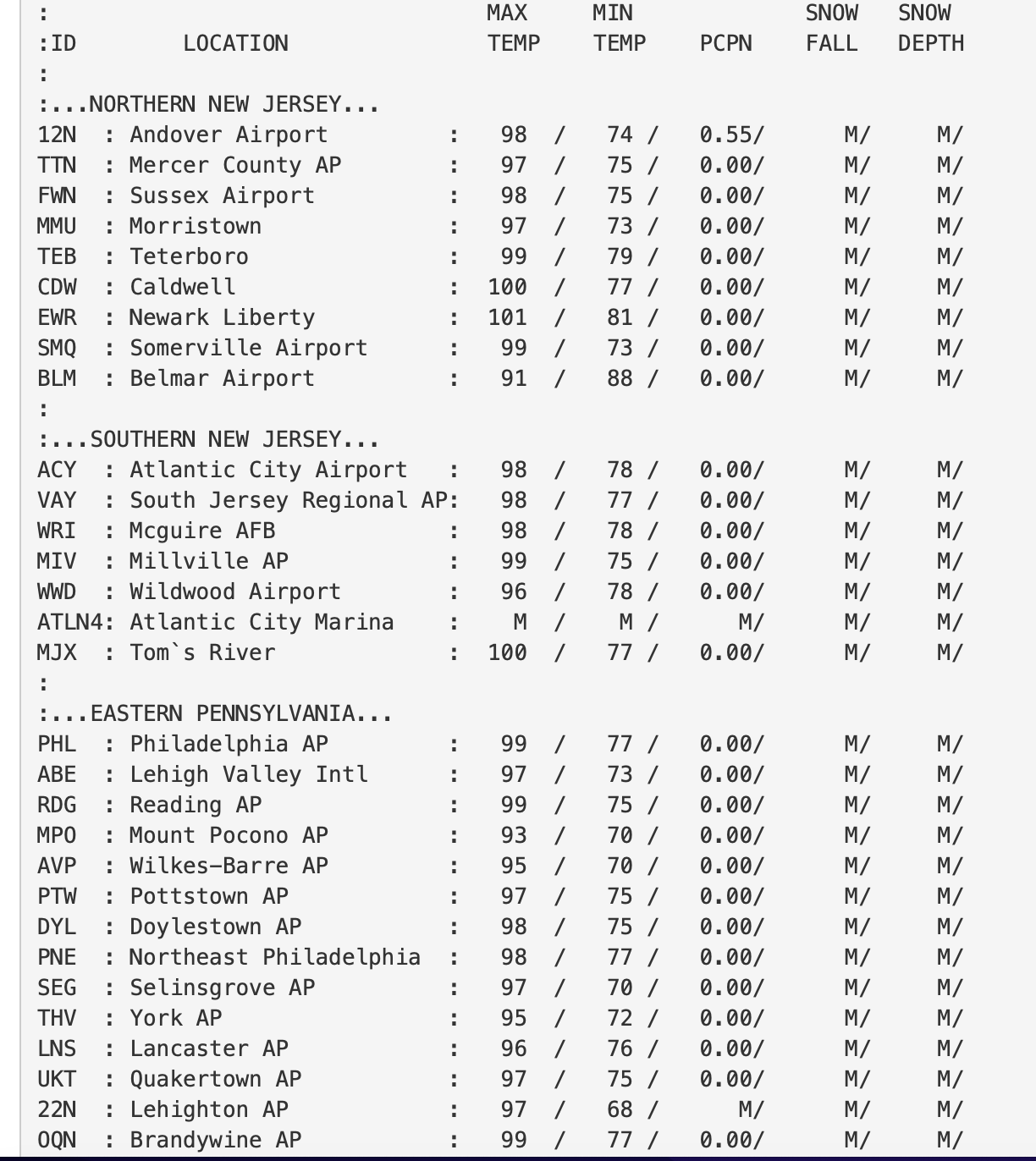
So, I aw Don's post-thank you. Added PHI max T RTP today below. HI generally less tomorrow but actual temp hotter and the overwhelming warmth aloft and w-nw BL flow will make it more difficult for sea breezes. My guess NYC makes 100-101 and KEWR close to 103-104. EPS has been pretty good! a third 100 degree day possible I95 corridor Wednesday, presuming it makes 100+ Tuesday. Despite the weak gradient, large low level lapse rates allow downward transfer of offshore nw wind from between 850-700mb.