

wdrag
-
Posts
4,409 -
Joined
-
Last visited
Content Type
Profiles
Blogs
Forums
American Weather
Media Demo
Store
Gallery
Posts posted by wdrag
-
-
1 hour ago, psv88 said:
Hi Walt. Just a question. Why do you lean on the Canadian so much? Doesn’t it have the lowest verification scores of all the main globals?
I haven't checked but its verification last year was #2.
Also, its' steadfast performance on the previous big inland event and the current one. It's a winter very good snow model.
We must disagree. Most folks dont pay attention to the CMC... so they dont really know.
It';s how you use these models. I'd say EC and GFS are a little shaky this coming event,
Differing input? Go for it.
-
 2
2
-
-
1/4 SW+AVP and KMPO recently. KABE nothing.
I think radar is going to have show yellows coming at you for decent snowfall.
-
2
-
-
Altoona 52 KT, DCA 49 kt last 3 hours, 40 KT AVP. Power outage just w of the subform (west of the Poconos). Power outages NJ at Noon just 259 which is routine and unlikely from anything now.
-
1
-
-
18 minutes ago, cleetussnow said:
Looks great lp and track
Its the GFS. Please incorporate Canadian into the thinking. A period of snow yes... snowstorm too soon to know for me.
-
2 hours ago, LibertyBell said:
Walt, will the Poconos be done with the snow squalls by noon time?
No
-
Not threading today, at least not yet. Too much melting much of the NYC subforum I95 east but its going to happen with a burst of snow (rain to snow LI) and winds during or within 2 hours after CFP, gust 45-55 MPH with iso power outages. Will look at this more closely once it gets out of the Poconos at 1130A.
-
3
-
-
1 hour ago, MJO812 said:
Not alot of talk about a possible snow event next weekend compared to other subforums .
This because they buy the GFS. I dont think the GFS is worlds best model around here. Canadian is better and it hesitates next Friday. Also, need to talk about today and Tuesday first. Then whatever we get after that is icing on the cake.
-
3
-
-
NYC: NWS stats prob of 1" snow this event... 09z/14.
-
4
-
-
No thread from myself until at least 830AM for short fuse snow squall gust 40-45KT even 11A-2P Pics and NNJ and 1P-3P NYC-CT. Slightly less modeling support than yesterday though I think it will happen.
No thread on Friday til at least tomorrow afternoon... a little concerned the ensembles les are favoring I84 for decent snow.
-
1
-
-
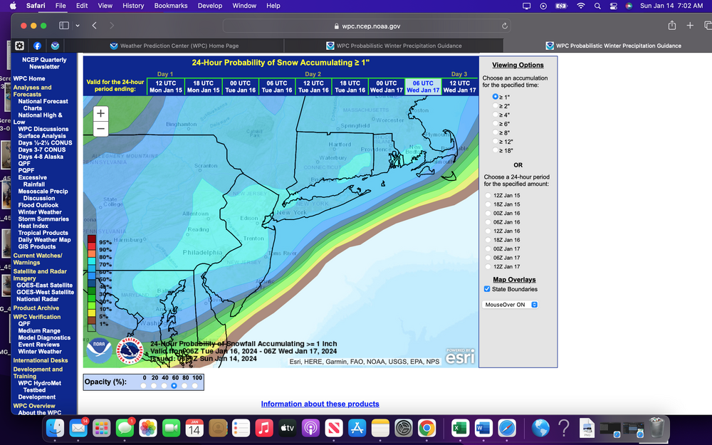
A couple of NWS probability graphics and my take on this based upon modeling through 06z/14
I 84 corridor inclusive of everything I78 north on Monday night-Tuesday evening. Hazardous 2-5". Periods of snow develop later Monday night ending Tuesday evening. Delays or even a few cancellations expected Tuesday morning rush. A little ice may mix in across NJ. Ground will be frozen as temps remain below freezing from sunset today-at least forenoon Thursday.
NYC. Hazardous snow 1-3" and possible ice-rain. Tuesday 1AM-8PM. Steady snow early Tuesday possibly changing to ice or even rain? Treated surfaces Tuesday should be just wet during the daylight hours but travel delays possible for the Tuesday morning rush hour. Max snowfall a little uncertain due to ice/rain and modeling was trending heavier

-
3
-
-
2 minutes ago, Tatamy said:
The Euro caves
Seems to be caving.. and we're not done yet. GFS too. Event hasn't happened so will have to wait til 00z/17 to know for sure. I continue with the RGEM/GGEM/NAM/HRRR blend. If the Canadian drops it... then its over.
Some of the modeling is showing 6+". axis should be near I95 or just northwest but we'll see. Definitely higher fluffier powdery snow ratios inland. Staying with 1-3" NYC...but no guarantee 1".
-
4
-
 1
1
-
-
3 hours ago, bluewave said:
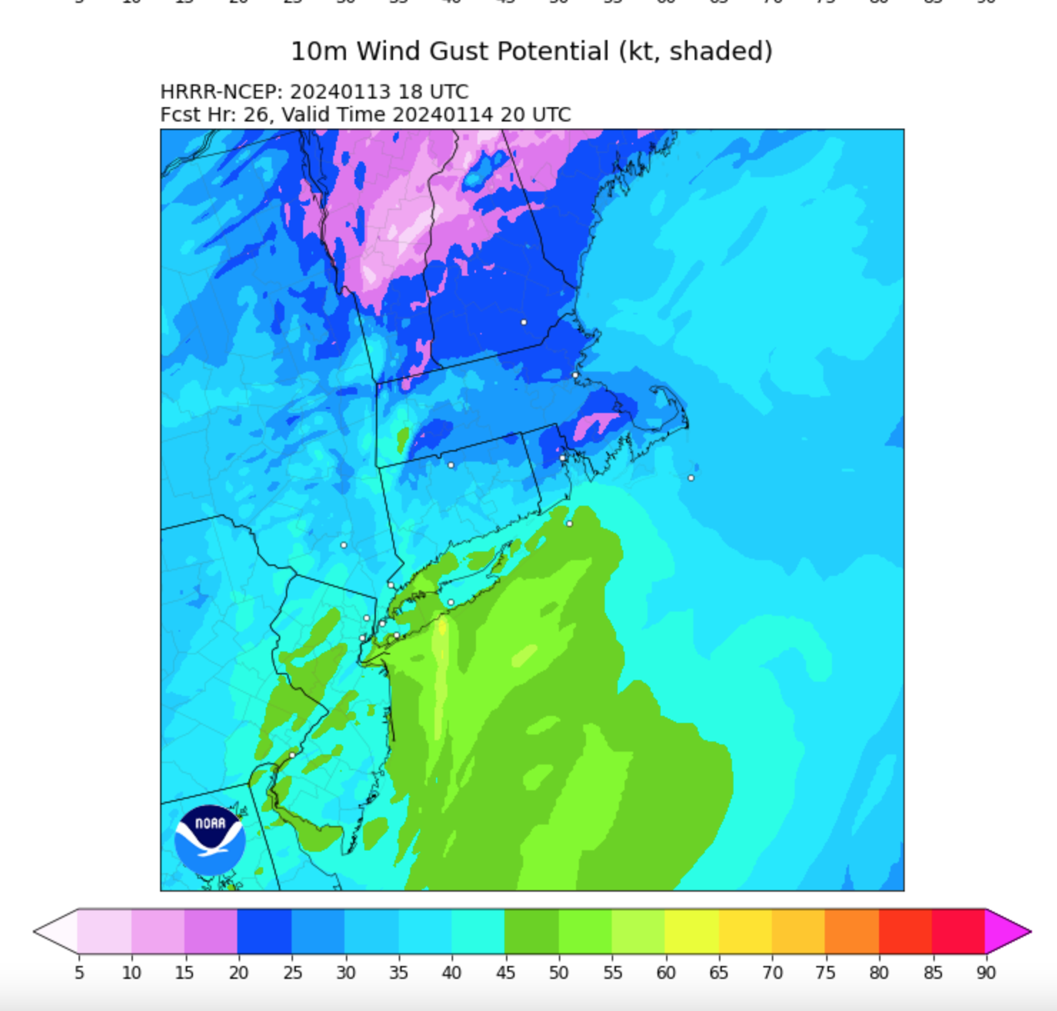
I am thinking we could mix down most of the low level LLJ to 50-60 mph or even higher in spots along the squall with the low level lapse rates near all-time steepest levels on record for this time of year.


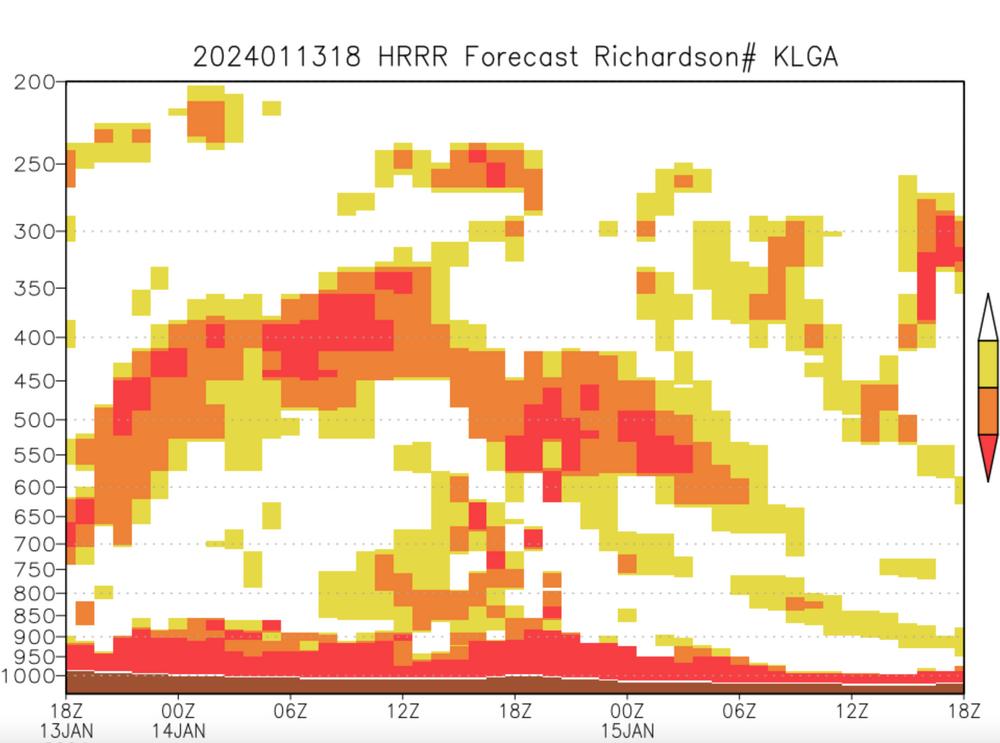
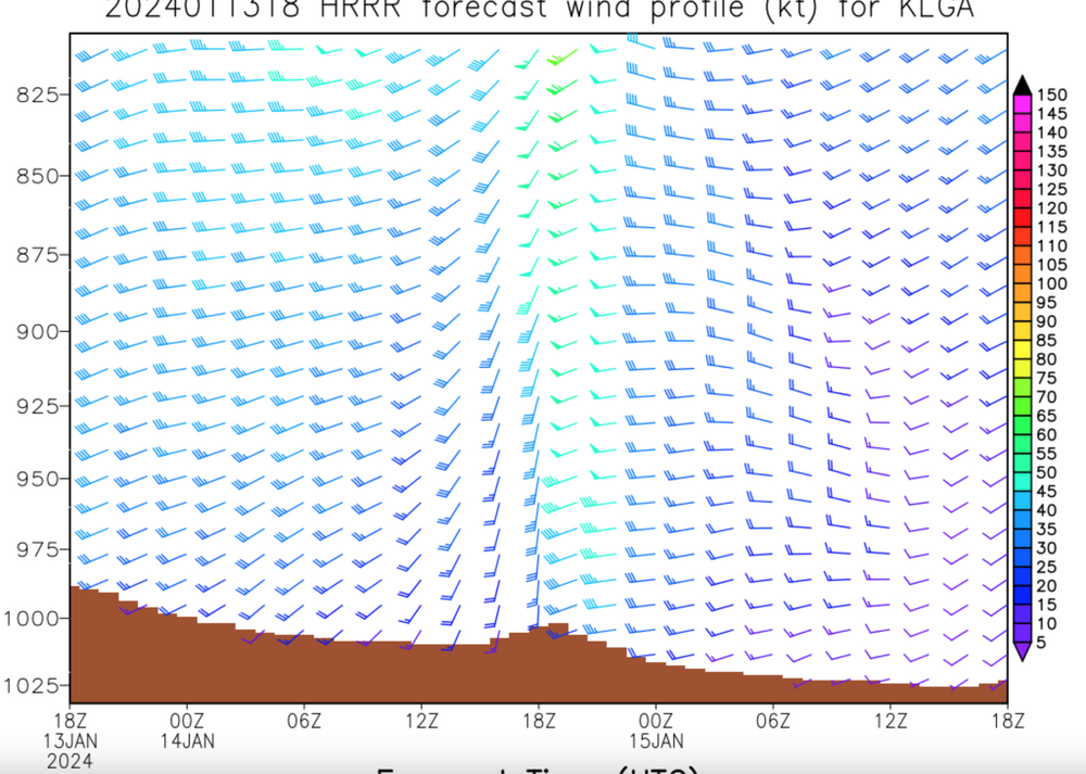
Am in full agreement, and after Sun early AM review will probably start short fuse NOWCAST OBS thread for this. Adding on a couple of graphics for the wind, including R#. Looks to me like this will maximize in our subforum and for now, the guidance favors power outage producing 2 min whiteouts (Trace -0.3") and damaging wind ~I80 south including LI (50-60 MPH per Bluewave), while longer duration squalls to the north of I80 where roads will be come suddenly slippery with 1/2-2" amounts and wind gusts more or less 40-50 MPH. Tsecs for LGA using the HRRRX

-
1
-
-
No Friday the 19th snow thread for NYC subforum til at least tomorrow evening. Want to get through tomorrow's midday squalls first, then be sure about the happenings for Tuesday and set it up from there if its more than 1" snowfall.
-
2
-
-
43 minutes ago, WestBabylonWeather said:
I’m not an expert by any means. So I’m not talking “at” anyone
but isn’t it just such common knowledge to wait for a big storm to pass (which just did) before using the models for the next storm
Modeling is constantly improving. Some of the old rules of thumb are not nearly as necessary
-
Y HOI e is Canadian. It’s usually slightly warm. Higher qpd less snow. We have time. I
-
So the 12z/13 NAM and RGEM have an event. modest, bu west of I95 hazardous, with a band of ice somewhere just west of I95 and decent snowfall ratios and powder I84 corridor. Let's see what other models say. Just have to ride this out a while longer but something is coming Tuesday. Not necessarily more than a light event but looks extensive to me.
-
6
-
2
-
-
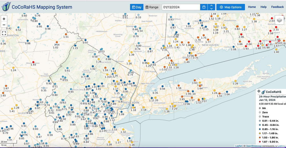
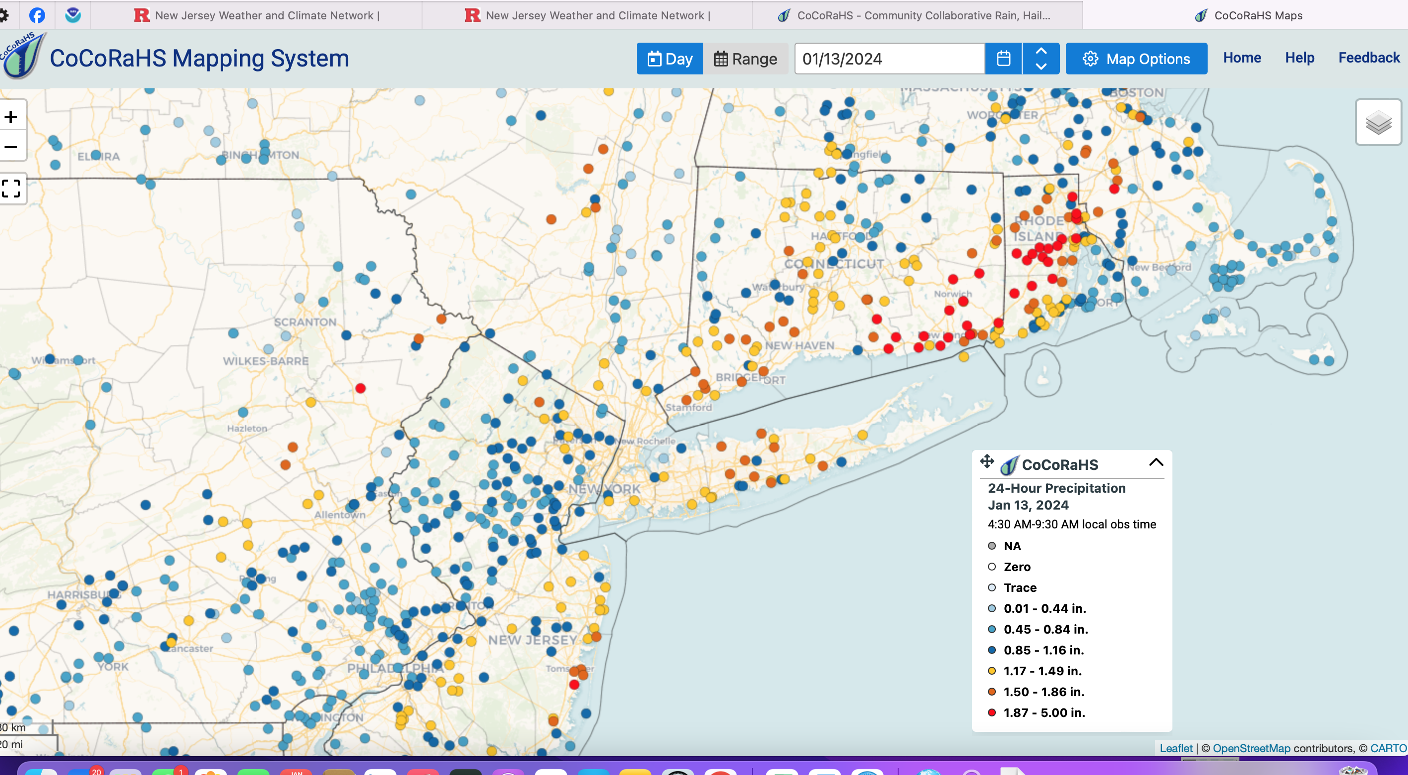
CoCoRaHs data as of 10A today...most obs before 8A. Red the biggest. click for clarity. NNJ rivers escaped a significant weekend rise since the 1+ inch was in the Poconos and east of I95. Still folks without power nw NJ and eastern NYS among the states.

-
1 hour ago, bluewave said:
The HRRR has unusually deep mixing with snow squalls and 50-60 mph gusts potential along the Arctic front tomorrow.

Good observation: Looks potent and would not surprise snow squall warnings PA/NJ/CT tomorrow. Just a matter of what sticks.
-
4
-
 1
1
-
-
Cold frontal potential bands of snow or snow squalls with steep moist low level lapse rates,. a wind shift and gusty falling temps below freezing soon after the cold frontal passage Sunday afternoon.
I84 corridor inclusive of everything I78 north on Sunday (that's NNJ/se NYS/Pocs/CT): A band of snow or snow squalls Sunday will accompany a strong cold front across the area. Accumulations variable, but expect 1/2-2 inches except less than 1/2" valleys. Prime time ne PA/NNJ/se NYS 9AM-3PM, CT-MA Noon-6PM. Blustery visibility may briefly drop to 1/4 mile in a few spots so be prepared for variable driving conditions...manageable but be alert to alter speeds etc. Falling temps well below freezing in the afternoon will mean potential refreezing of any melted snow.
NYC-LI: Probably melting upon contact but grass might get a slight coating and it could look impressive on time lapse if this comes to pass Sunday afternoon.
-
7
-
-
Keep looking and monitoring: I, as does WPC (their products) agree with posters... the snow is coming. RGEM-CMC consistency should be monitored. Axis is variable. Latest RGEM - 06z/13 version, I sort of like. Looks like 1-4" I95 west and has ice near the I95 corridor. NAM seems too warm=north.
I did check the NAM and a banding signal is evident so that contributes to the powdery potential.
How this plays? For now, I think this is a powdery interior hazardous modest impact event on previously frozen ground (4P-Sunday-Tuesday) with decent snow ratios, higher than 10 to 1 for the interior (NOT the WET 7 to 1 ratios). I can see ice or rain for I95 or east of I95 so for myself in NYC CP, I'll stick with for 1-3" by sunrise Wednesday. Confidence a little below average on what happens NYC (but a little above average interior). I think staying conservative in NYC is best for now and just monitor the modeling... for me I need the GGEM, RGEM on board for this to happen.
fwiw...if interested see January thread for the Sunday cold frontal passage snow squall event that seems to be looming for our NYC suibforum
-
5
-
-
MEH... Winds generally below 40 knots so far. 50 KT Scranton and power outages northern PA, eastern-central NYS/ northwestern NJ where 62 Mph occurred near Hamburg Mountain. Max rainfall missed the previously flooded basins (missed to the east) which is a good thing so the second even higher stage for the mainstreams may not occur in NJ. Will post CocoRaHs map and any LSR's around 10A, as time available.
-
3
-
-
OBS thread should you have anything to report. I think most of the obs reports will be early Saturday.
-
6 minutes ago, MANDA said:
The AI modeling did horrible with Lee over the summer. Several consecutive runs tried to plow a major hurricane into New England. Eventually they came around to the actual outcome that most of the op models had a few days prior. Use this AI stuff with caution.
I can only presume AI assisted modeling was tested for improved guidance prior to its implementation. Recommend staying with WiC and check their afternoon EPD when it comes out
-
19 minutes ago, Nibor said:
I believe @bluewave has commented on how they’ve integrated AI into the euro.
Was it aware - thanks


Sunday 1-14-24 Snow Squalls & High Winds
in New York City Metro
Posted
ALB 50 kt, LGA 40 KT. EWR 37 KT.
Snow squall warnings might have been a little liberal east of the mountains. Really need those bright yellow returns, partly indicating ice and or large flakes.
A couple hours of gust 35-45 kt then it calms down a bit near sunset.