

wdrag
-
Posts
4,409 -
Joined
-
Last visited
Content Type
Profiles
Blogs
Forums
American Weather
Media Demo
Store
Gallery
Posts posted by wdrag
-
-
10 minutes ago, lee59 said:
I have not seen any reports as of 7a.m. but TWC says it is official. We shall see. Apparently they have been adding the hourly updates in Central Park.
I hope they didnt use X. X is not a standard PRIMARY dissemination tool for met purposes. Poor policy if it is since people like myself dont use twitter---
-
5 minutes ago, CPcantmeasuresnow said:
It was a bogus record to begin with. Two consecutive days last February with 0.9 inches and they kept going on about how it hasn't snowed an inch for two years. Definitely a bad stretch but what's the difference 0.9 or 1 inch. The way they measure either day could have easily been more than an inch.
I agree 100%. A lot of the news is to sell interest (vis a vis EPIC, Bombshell etc). That's why daily records are helpful but incomplete for precip. Need 24 hour records for precip events... and 48 hr etc but cross midnight CLI purposes. Too difficult, I'm afraid. At least this is behind us. Enjoy the snow and ice.
-
 1
1
-
 2
2
-
-
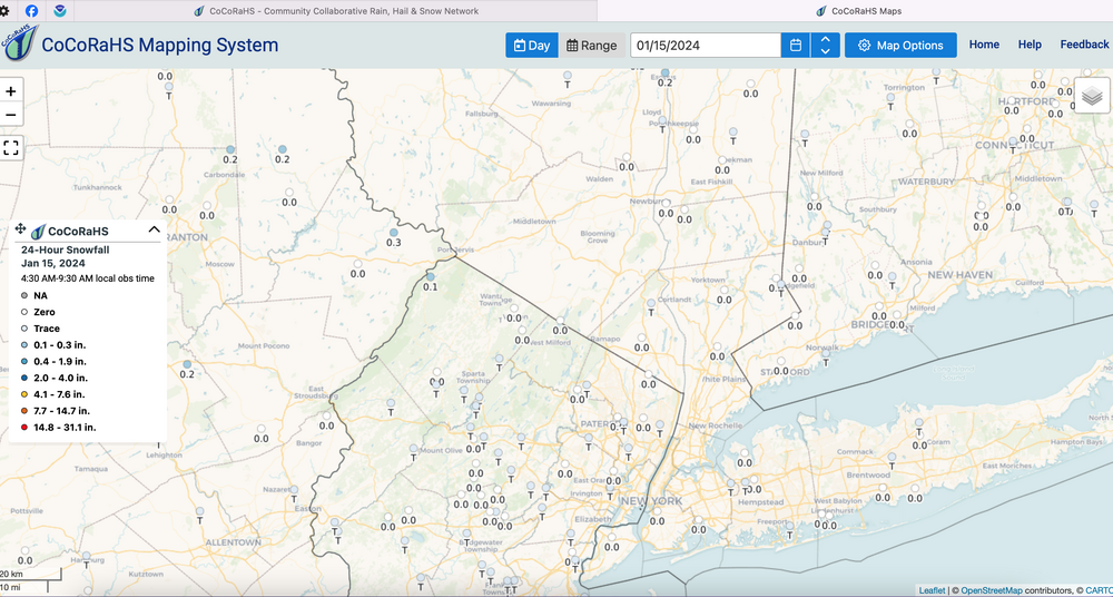
I just used CLI at midnight and the 1" written on here.
-
Just my opinion: I think in fairness to the ENTIRE community of met interests... I sure hope TWC did not get this snowfall first. This has to go out in a standard product that everyone can access (not FB or phone). I will stand corrected if someone can show me the product. Thanks, Walt
-
 1
1
-
-
That makes it 1.4 for CP for entire event through 7AM.
-
Just now, lee59 said:
Central Park hit 1 inch since midnight, record ended.
I am so far behind you ... where did you find this? What product?? Thanks, Walt
-
Definitely a little short at sunrise, amounts up here NNJ. Disorganized around our NYC subform but its not over, especially with temps in the 20s. about 7 more hours in NNJ. going to have trouble exceeding 4" here in Wantage, I think. 1.4 right now.
-
I'll be looking for CP snowfall which in the past 6 hours might. be under an inch, but for the day? hoping 1". Then when it changes to ice, will they measure at the changeover? I don't know policy - constraints.
-
Wantage NJ 8s High Point in Sussex County. 1.1" at 440A. Plowing I progress. 20.5F
-
Quite a nice snowstorm developing for the big cities... even Richmond. We worry too much, I think... let's count on a good deal of what we haven't seen much of in the cities at sunrise. After that, so be it. Enjoy this snow! mPing has it on south shore LI!
-
10
-
-
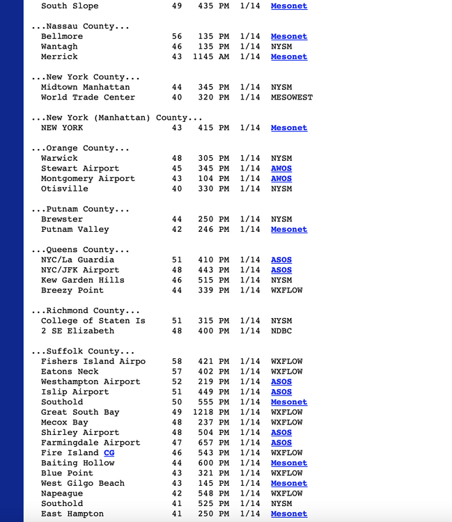
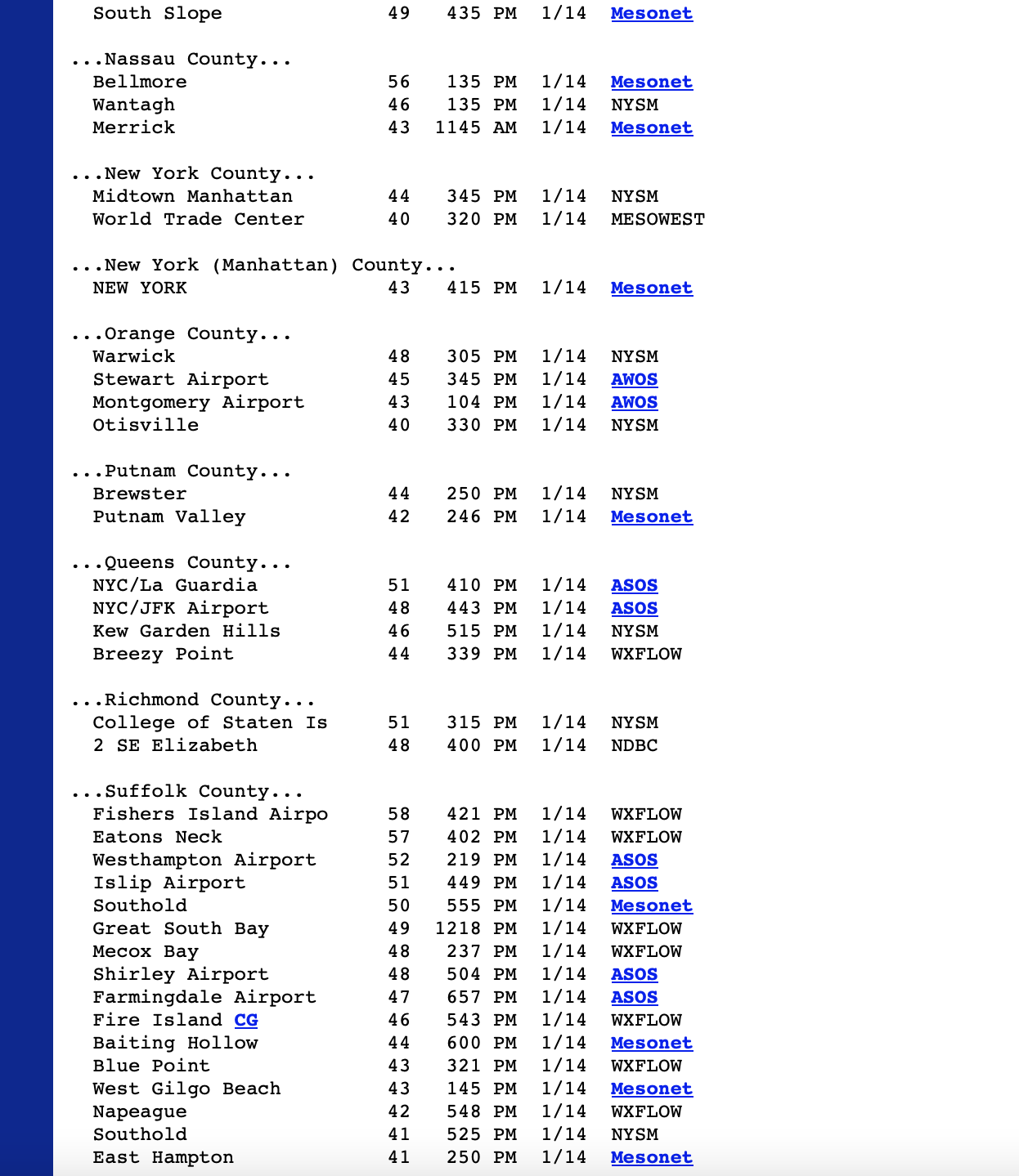
BWI moderater snow at 7PM and I think they are over an inch now.
DCA may be at 1.5" since I saw a 4/002 indicating 2" on the ground there.
-
4
-
-
13 minutes ago, gravitylover said:
That would be two snowstorms in a row where the better amounts go around me to the N/NW by just a few miles
It's just an estimate. I ,or the modeling might be wrong-there's hope. Enjoy waking to a whitened landscape.
-
1
-
-
fwiw on the megalopolis cities first 1".
DCA AT 4P 0.7. Since then en ought measurable to suggest at least 1"
BWI at 4P 0.5. Since then approaching 1.
PHL Trace through 4P.
I've seen 1-2": near Richmond and just southwest of DCA, with 0.5 to near 1" DCA-BWI.
This seems to be a mainly Tuesday morning snow-ice show for our NYC subforum...about a 12-15 hour event. Short term guidance is getting pretty firm on warming aloft NYC and to just west if I95 near or just after sunrise. I'm not counting on. the globals regarding changover.
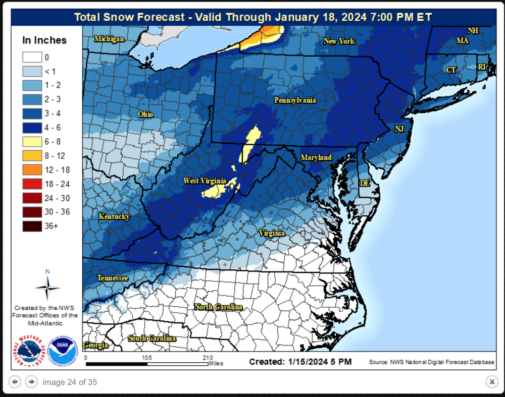
Best snow in the broad 4-6" axis in dark blue. I think this forecast may be 2" too low in northwest Ct/w MA.
-
3
-
1
-
-
Just a reminder continue with obs and now casts here and pllllease enjoy this. Its a nice wintry event. CP should beautiful in the morning. Thanks!
-
6
-
2
-
-
Am seeing some banding tomorrow but snow growth looks a little lackluster. I probably wouldn't inflate this event past 5 inches for the I84 corridor-ABE,
-
6
-
-
DecJan: I hope everyone is enjoying the extremes this winter season has brought us so far. Obviously a nice winter week in progress. Is this all there is after the big warmup the middle of next week?
You never know, so good to take what we have or is imminent and enjoy it to the max.
I'm no long ranger so taking what I have available through Jan 30, ensembles qpf 1.5-2.5". If the max 2.5... CP would be #10 wettest Jan (6.0") and Allentown #4 with (6.7") respectively. Long ways to go and easier to have a shortfall.
To me its looking interesting again from next weekend (27th and beyond) for mixed wintry events.
-
4
-
-
This event was ok...but not quite as expected (disappointing for me).
Few gusts 50-60MPH with power outages, especially western NJ westward across PA and north through NYS.
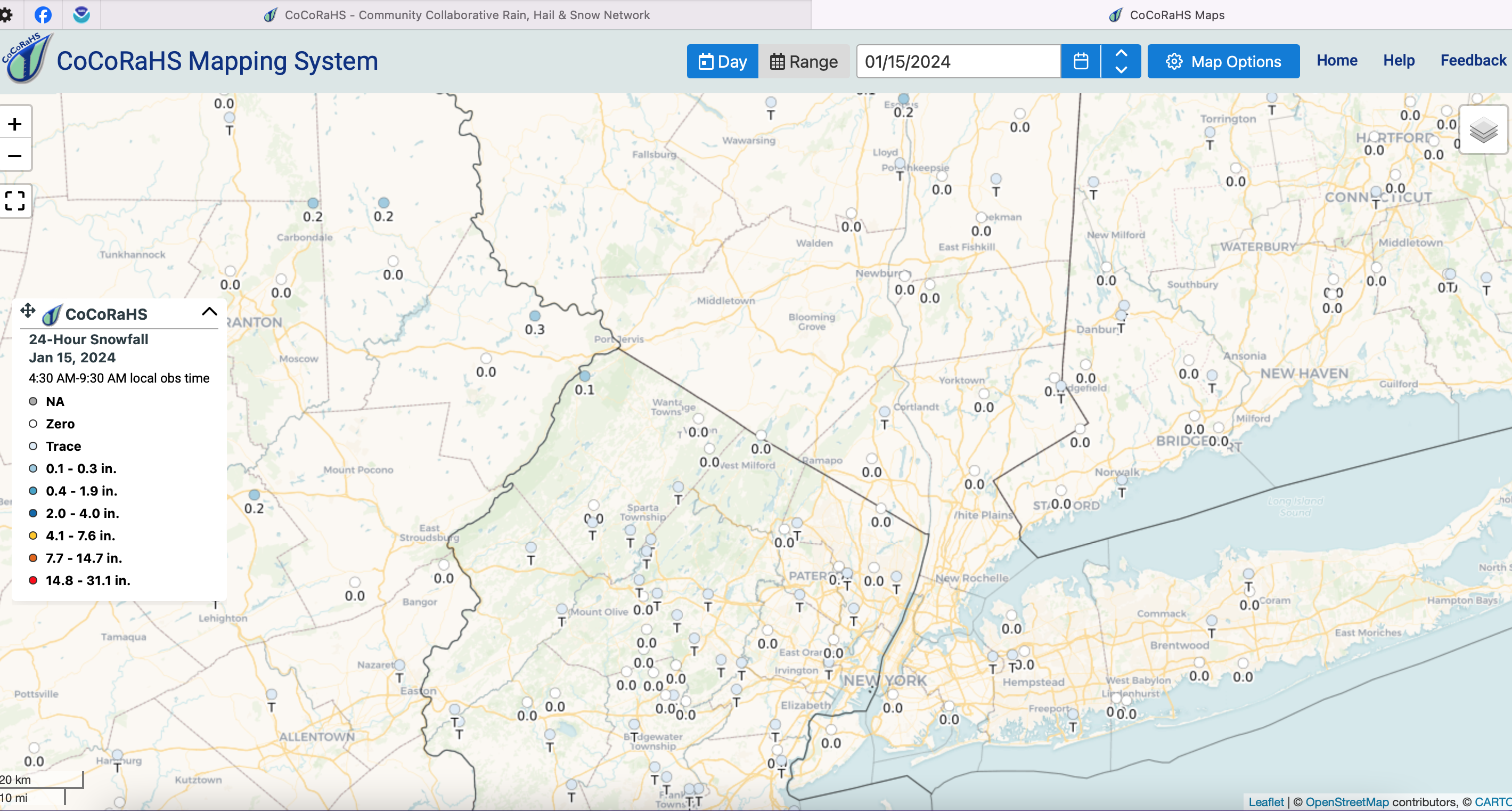
Best snow squalls our area (1/4 mile vsby) were probably the Poconos and then as the blue wave TL above, up near and north I90 in NYS/MA. CoCoRaHs snowfall our area yesterday is attached-click for clarity. Also attached the Li portion of the NYC PNS wind gusts from Sunday afternoon. I always like to see a solid wrap on all these event threads.
-
1
-
1
-
-
Not changing the thread title. it's good enough and rode it from start to finish. OBS in here as well. Thanks, Walt
-
4
-
2
-
-
I think media is underplaying impact and amounts... almost certain to have a band of 3-5" just west of I95 into ABE-SWF axis. NYC might end up with 3". Their first 2 inches should be on the ground by 7A Tuesday. ICE is coming too along the I95 corridor.
-
8
-
-
Looking good NYC for 1.5-3" and a little ice from a 12 to possibly 18 hour event.
Persistence from mesoscale models suggests a band of 3-5" eastern PA up the I84 corridor including nw NJ but ice temps eastern CT northeastward.
-
3
-
-
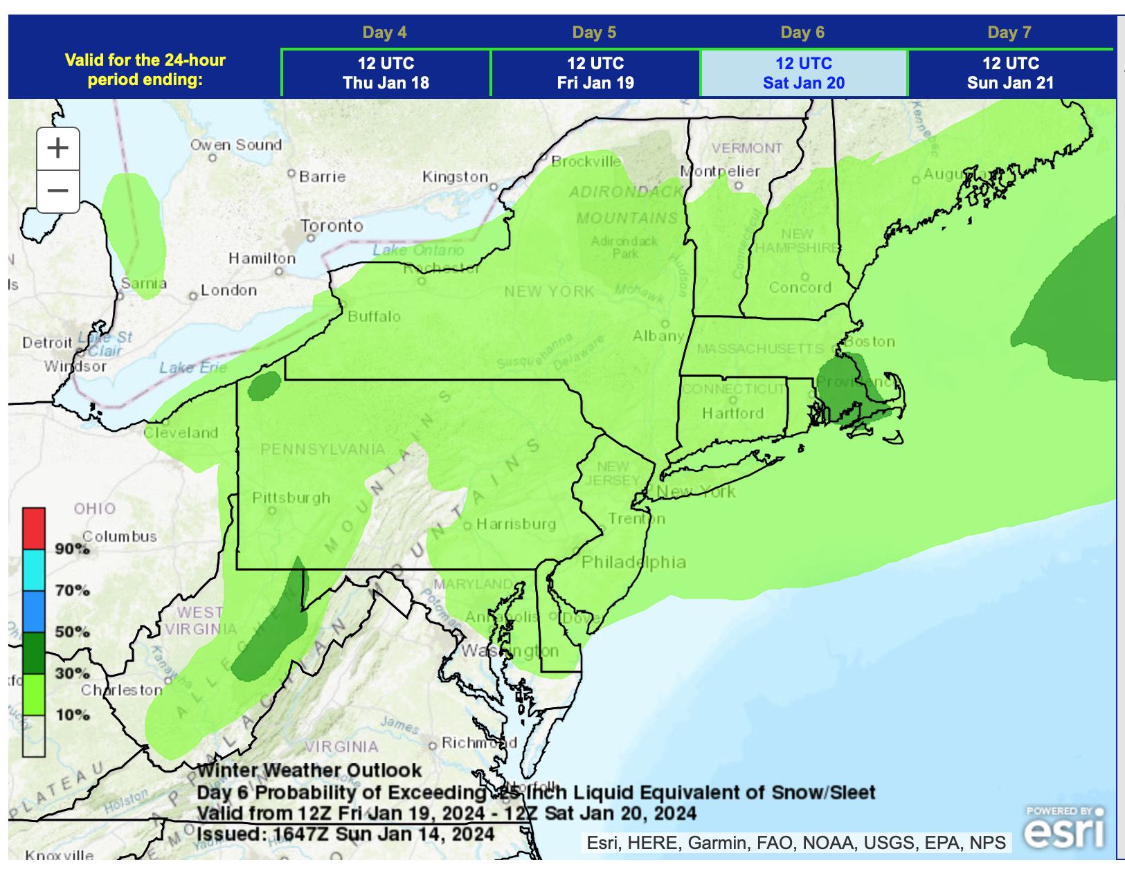
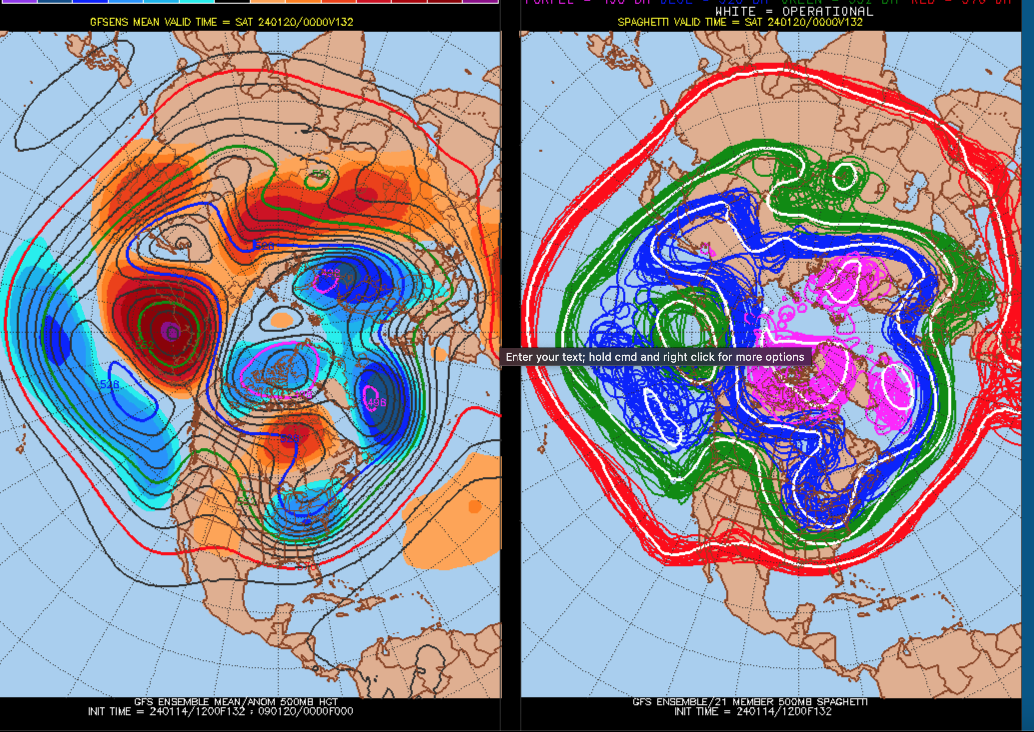
This post is at the seeming urging of multiple models this weekend offering a period of snow to the NYC subforum. Presuming it occurs, it could begin late Thursday the 18th, or it could linger into early Saturday the 20th. The coldest air of the season so far in NYC, may follow on gusty northwest winds next weekend, the 20th-21st.
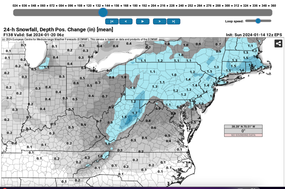
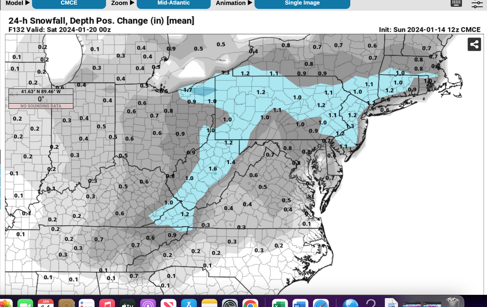
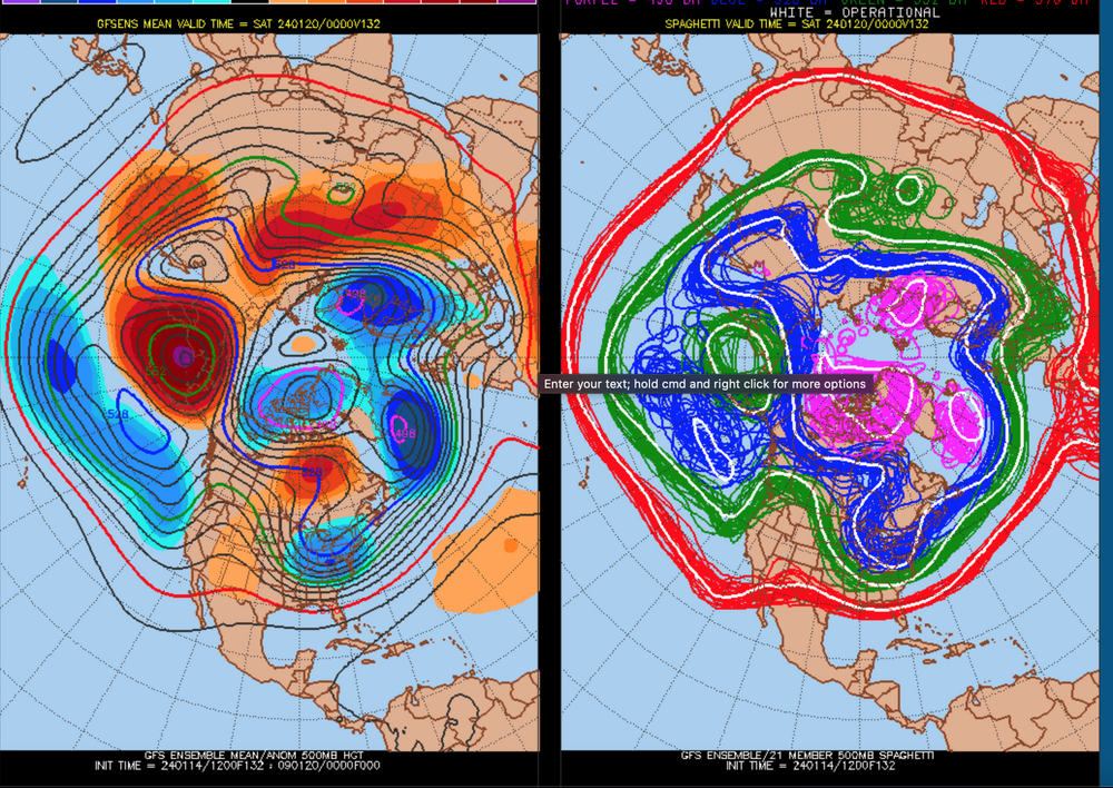
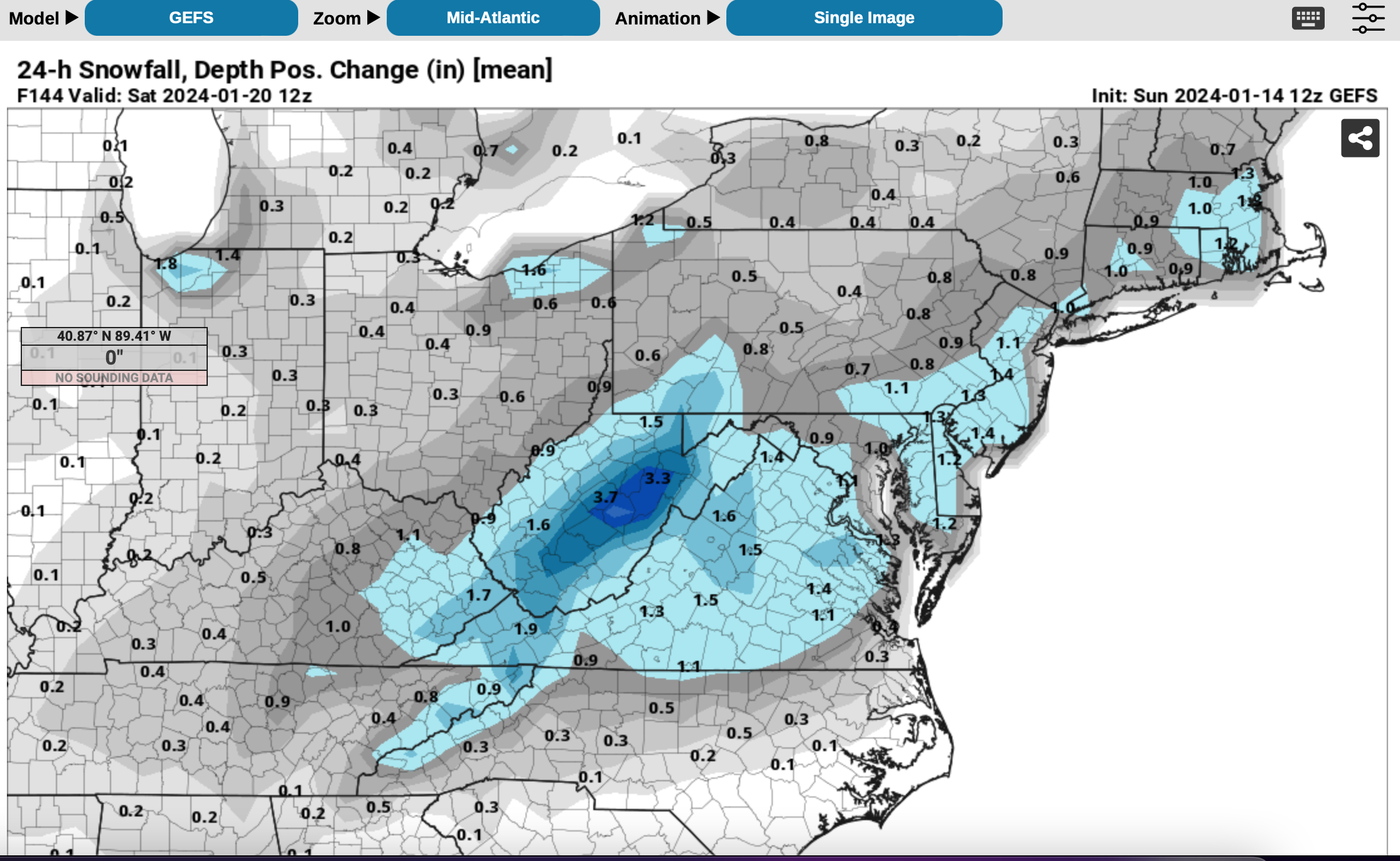
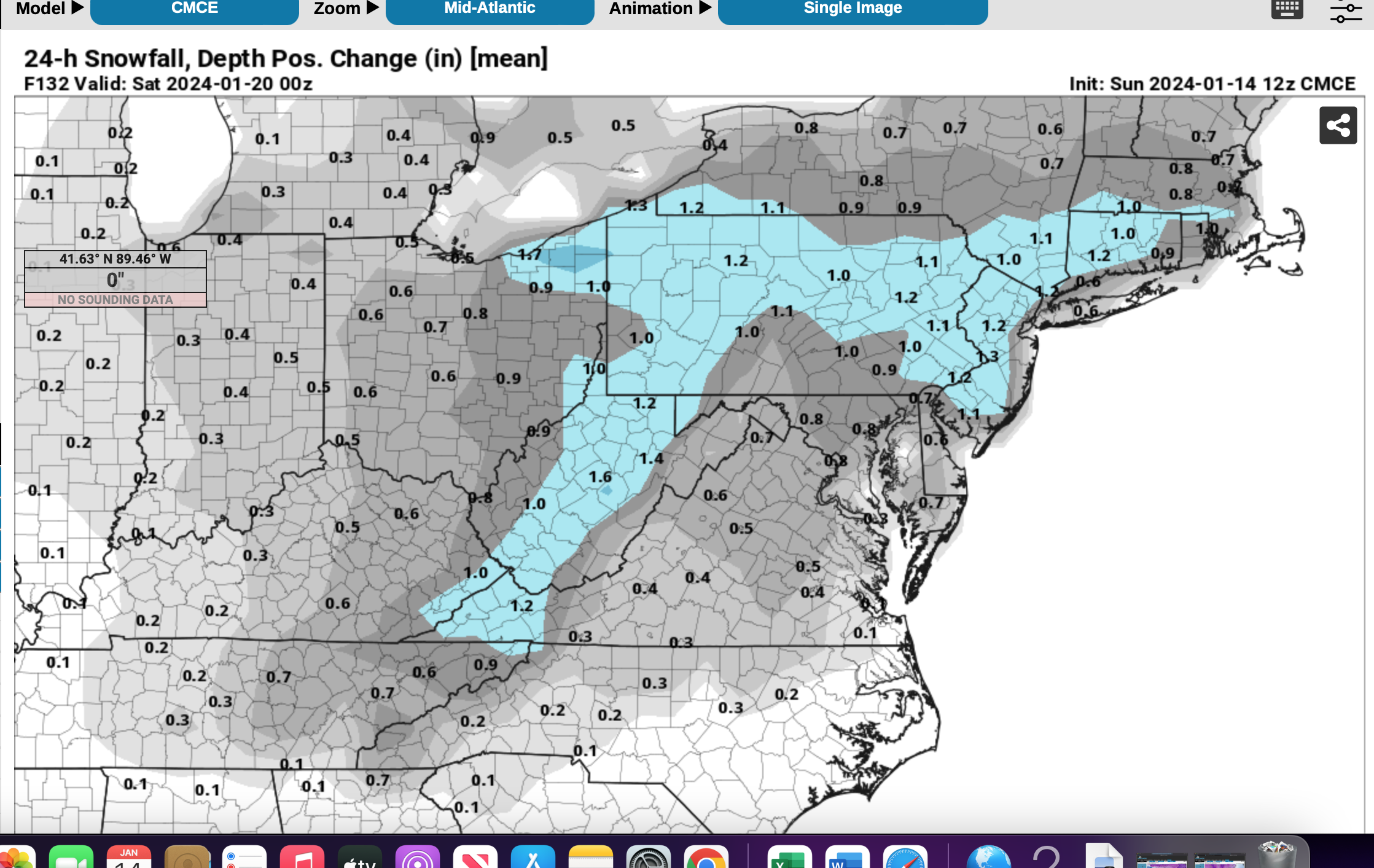
There doesn't seem to be anything definitive per this Jan 14th issuance, except that a period of snow is expected for at least a portion of NYC subforum on Friday with below normal temps. It's a strong positive tilt trough that approaches from the Great Lakes-Ohio Valley late this coming week. Attached the 12z/14 GEFS 500 MB mean left panel and 500 MB ensemble membership right panel.
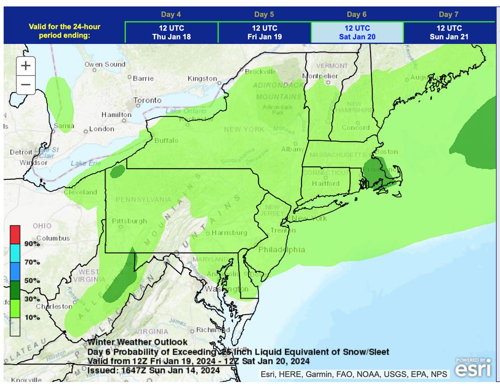
The NWS Sunday 'day' shift ensemble chance of 1/4" or greater snow-ice is attached as well as the 12z/14 EPS 24 hour positive snow accumulation ensembles ending around midnight Friday night. The 18z/14 GEFS was lighter for the same period so I extended the 24 hour positive snow depth ending time to sunrise Saturday whereas the CMCE was faster with the snow so I ended it 00z/20.
Overall this Dec-Jan winter, it is my impression the GEFS tends to be conservative forecasting snow, the CMCE more liberal with more abundant qpf as well.
I may have to add rain in the tags for the coasts as we draw closer to the proposed thread day... for now the colder solution was favored but uncertainty exists.
Title addition 1/17/24 503AM: Event OBS. Tags: added rain/snow mix.

-
2
-
-
Eastern PA power outages wayyyy up. 86,000 meters out in PA now, only 2300 in NJ as of 215PM. I think I saw 51kt at KMDT
Combined snow showers and wind risk...useful thread.
-
5 minutes ago, Stormlover74 said:
I can ask for the nam to stop giving me sleet
Mid level warming. EC doesn't have it. RGEM does. I think we need to pay attention to RGEM-NAM blend. EC and GFS flagged a significant event when the Tue thread was started then disappeared only to slowly return.
The global models (EC-GFS) probably handle closed lows situations better then general WAA overrunning. Someone with knowledge of the models are welcome to check me on this.
-
1
-
-
Hi! I'll set up hopefully a carefully worded snow thread for Friday (late Thu-early Sat). Enough modeling has a cdefinite period of snow, or a moderate snow storm, take your pick. I'll check the ensembles this evening. I think we can wait on this a bit longer til this evening, before getting ahead of ourselves especially since ensembles are as of yet not more than 2".
I kind of like a reasonable chance of getting snow accum in NYC and/or a 6+ just west of I95 for our I84 Pics/nw Nj slot before getting the thread going.
Thanks for your patience.
Walt
-
2
-

Potential extensive winter event, I-95 west and with again a chance for NYC first inch(es) of snow Mon or more likely Tue Jan 16, 2024 (serves as OBS thread as well)
in New York City Metro
Posted
I'd leave it on... melting may occur on pavement but the key for me..any ice that might accum on a recently shoveled untreated pavement. your decision.