

wdrag
-
Posts
4,409 -
Joined
-
Last visited
Content Type
Profiles
Blogs
Forums
American Weather
Media Demo
Store
Gallery
Posts posted by wdrag
-
-
4 minutes ago, Volcanic Winter said:
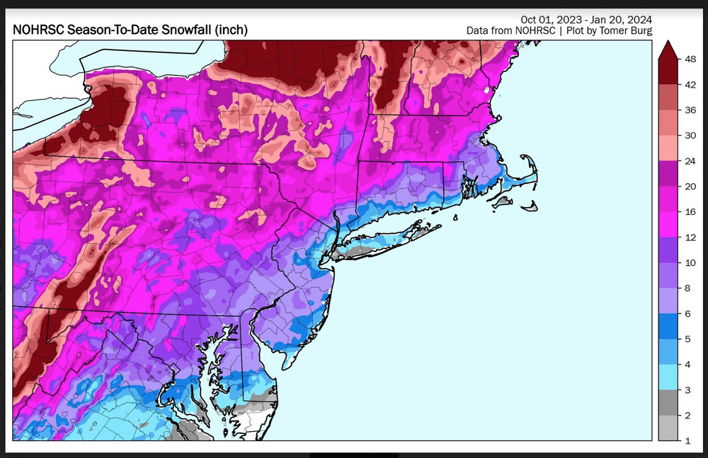
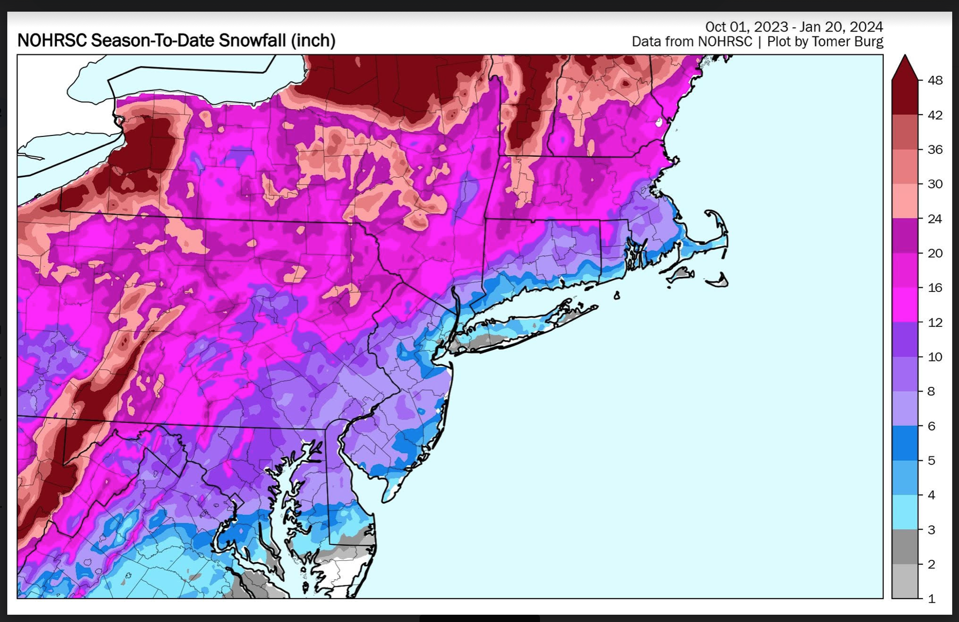
Just looking at snowfall to date the strip of purple to blue at the immediate coast from Boston all the way to DC is pretty crazy. I hadn’t realized the Cape & CT coast are pretty much in the same position as the immediate NYC metro. Shows how the warmth is a problem all the way to Boston along the immediate coast, though them doing a touch better is of course expected.
Really hoping something works out in Feb.
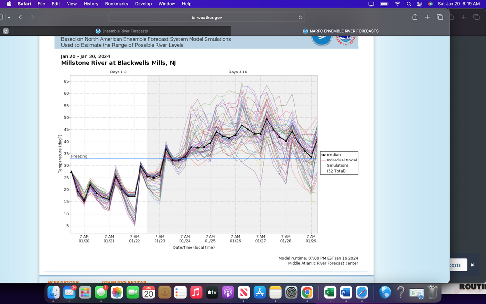
Fingers crossed--just added some climo #s for the megalopolis.
-
 1
1
-
-
NYC nearby interior suburbs. Tuesday night: small chance of icing from a bit of sleet or rain refreezing on frozen ground. Ensemble ice graphic added. Noting the EPS has the freezing rain as well.
Sunday the 28th-Wednesday the 31st: One or possibly two hazardous wintry events of snow and/or ice. Vast uncertainty on when-what. While not favored for snow in NYC, I think there is a chance for a half inch of snow at CP as a start. Pattern somewhat similar to that of Friday but without cold air in advance, so this will have to be with the departing mid Atlantic coastal low. No attendant graphics at this time and no thread since I think the risk for light to moderate extensive event from BWI-ALB-BOS is inland from I95. I've seen yesterdays comments-stats on unlikely and we'll leave it at no chance snowstorm NYC but I do think a wintry event is coming, at least to our interior Sunday night or Monday.
I add several graphics: One is the chance of ice Tuesday night. (maybe a better chance of ice pellets-snow flurries at the start in NYC than any ice?).
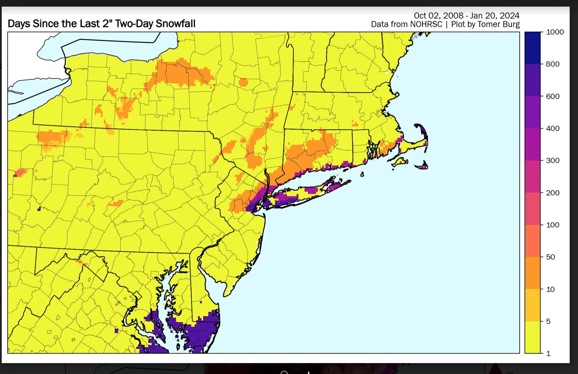
And Tomer Burgs excellent graphics on the so called snow hole. I'm on another group that discusses science. Snow holes are probably random. DC-BWI-PHl are getting snow in this pattern and yet we may miss the rest of the winter but each event has its own set of difficulty. RANDOM on the NYC snow hole-probably--just not enough stats on these snow holes. Another snowhole is apparently ongoing in MN.
I'm pretty sure some on here were disbelieving the potential with Fridays event(verification graphics on the 19th thread) and NO was a right call for NYC and probably again this period of 1/28-31, but I think it worth monitoring. I'm pretty sure something wintry happens in NYC 28-31. No thread from me on this yet. Additionally ensemble modeling continues pretty good qpf here the rest of month 1.5-2", the big 4+ flooding stuff in the Gulf Coast states.
FWIW: 19" here in Wantage in January and more coming in January, DC-BWI-PHL-ABE-BOS roughly 8-10". BDL ~13".


-
3
-
 3
3
-
-
Posting here since this is currently not a likely risk for NYC. Multiple models and ensembles have both these events pegged. Early next week is WAA and then the one lager Sunday or next Monday is with a a decent positive tilt 5H trough passing eastward through our area...somewhat similar to Fridays event. Long ways off but 00z/21 EPS has it. I can live with what is appended below.
Massachusetts-northern CT Tuesday afternoon-Wednesday morning: 1-3" from periods of snow with some sleet possible and this should change go all ice Wednesday morning with delays likely-at least for the hill towns. Treated roads should be just wet in the valleys after 9AM Wednesday. Sunday the 28th-Wednesday the 31st: One or possibly two hazardous wintry events of snow and/or ice. For now this is shaping up as a potentially extensive-moderate event Sunday night-Monday but uncertainty so don't take it to the bank yet. However, if making plans-suggest factor in possible delays.
Northern NJ-Poconos -southeast NYS 9 AM Tuesday-9AM Wednesday. Periods of sleet-snow Tuesday changing to maybe one tenth inch glaze Tues night-Wednesday morning. Icing not major but certainly a hazard since the ground is frozen. Delays-cancels-especially Poconos-Sussex County NJ and se NYS Tuesday night-Wednesday morning with possible early dismissals Tuesday midday. Temps may briefly be above freezing Tuesday but once the precip starts it drops back below freezing through 9AM Wednesday. Treated roads should be just wet but more careful winter driving is suggested. Sunday the 28th-Wednesday the 31st: One or possibly two hazardous wintry events of snow and/or ice. For now this is shaping up as a potentially extensive-light to moderate wintry event Sunday night-Monday but uncertainty so don't take it to the bank yet. However, if making plans-suggest factor in possible delays.

-
2
-
3
-
-
3 hours ago, WestBabylonWeather said:
Kings park definitely had at least a minimum of 1” maybe 1.5
Just saw a movie so won’t catchup til tonight but the comment on PA cocorahs and jfk
-
1
-
-
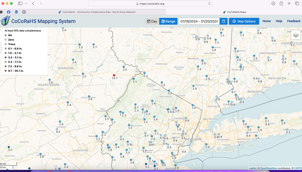
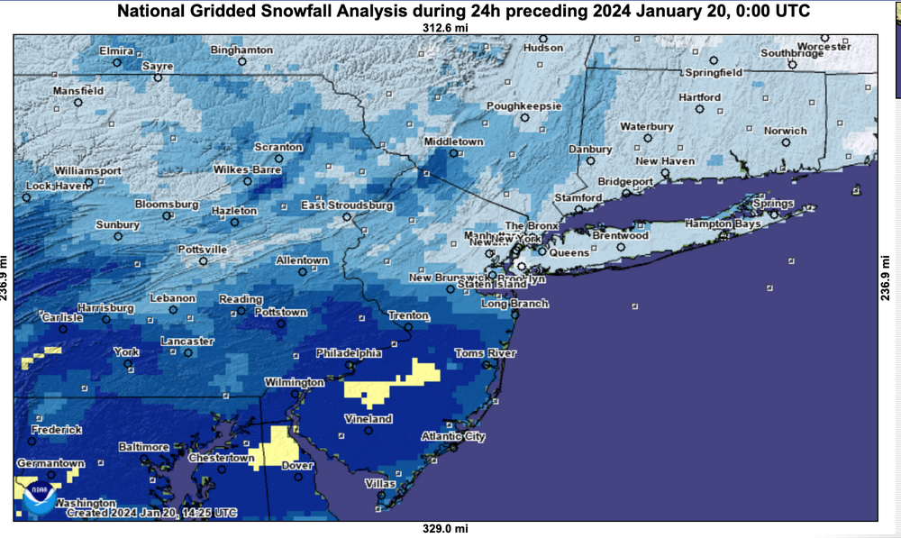
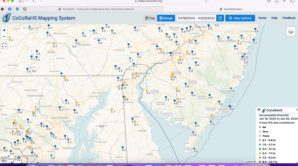
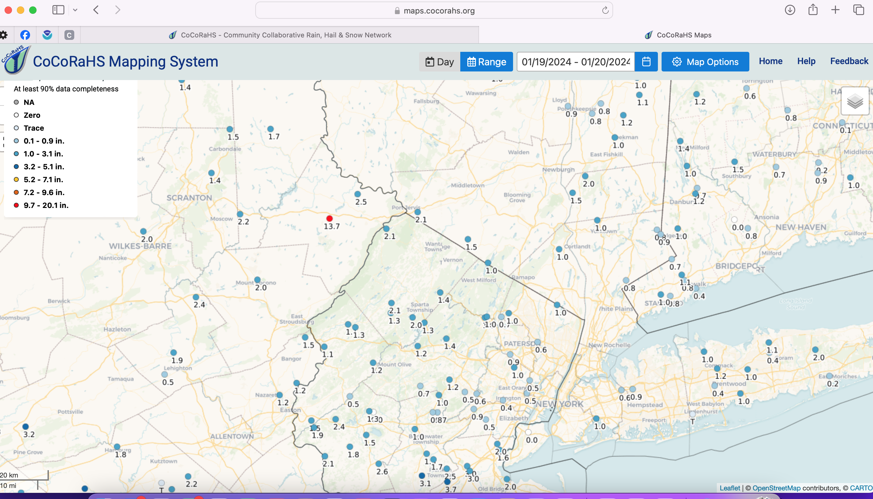
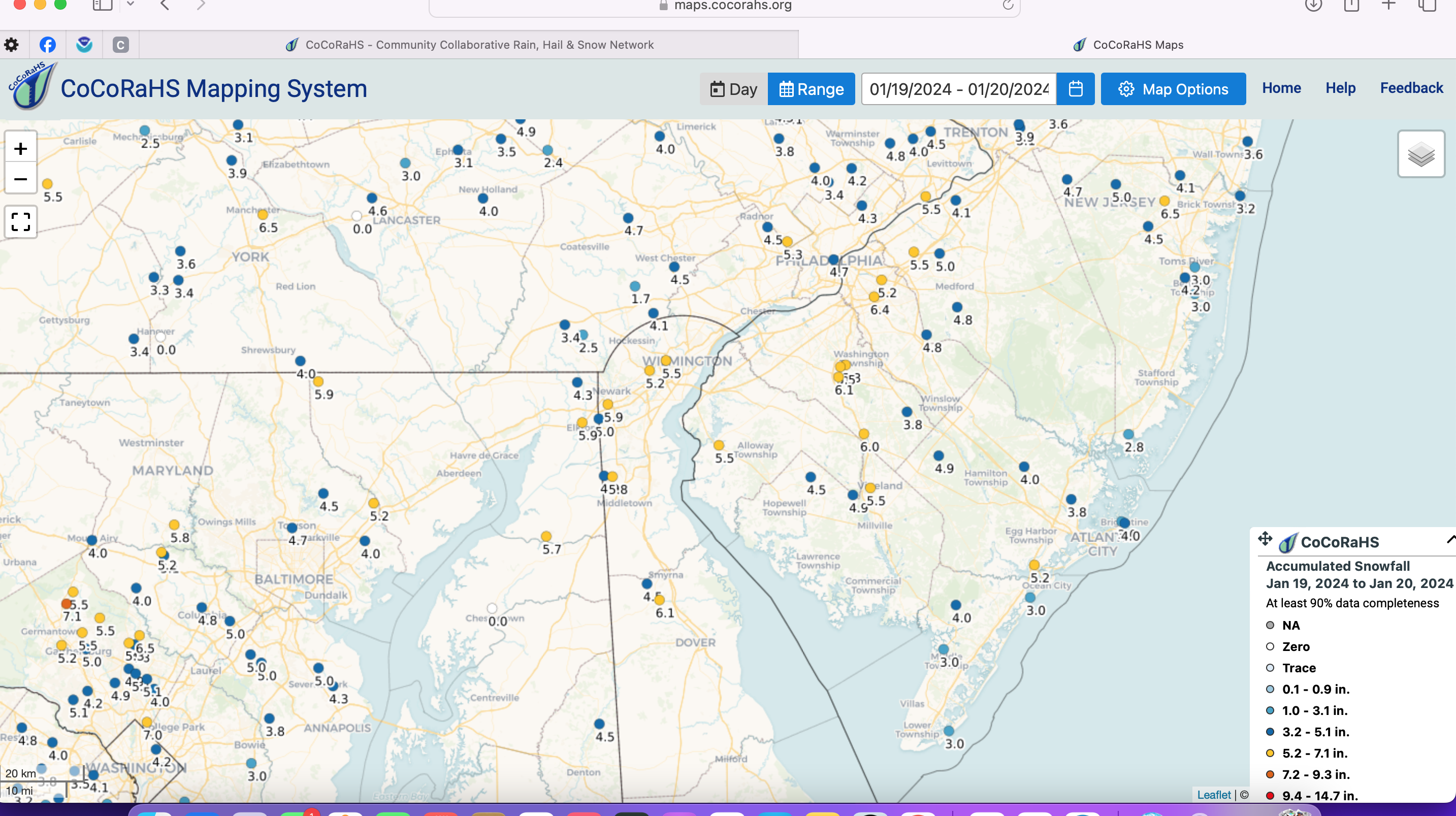
Summary 1/19/24 event: Variable 1-3" snowfall in the sNYC ubforum with less than 1" parts of Li/NYC area and 3" or more high terrain around the Northwest edge per satellite-human interface. General 3-6" DCA-BWI-PHL up to near or just south of I78. GEFS best modeled snowfall upon thread initiation (Sunday the 14th) and overall 5 day target was decent with a tendency for modeling southward slippage toward MD as T0 (Friday the 19th) drew closer.
-
2
-
-
7 minutes ago, kdennis78 said:
Uh oh. Like 3"-5" of rain in 6 hours with a cutter or coastal storm interesting? My yard is clay soil and nowhere for water to seep down anymore. Simply can't handle that. Not near a river thankfully.
Not thinking at all 3-5" of rain in 6 hours. Thinking several events add up, plus a little snow melt & a little frozen ground and ab eve normal antecedent flows/soil moisture. If some of this is snow-ice (which it could be west of I95), then that slows runoff and reduces the potential.
-
5 minutes ago, LoboLeader1 said:
Pac jet pushing across the country next week, leaving coast to coast warmth.
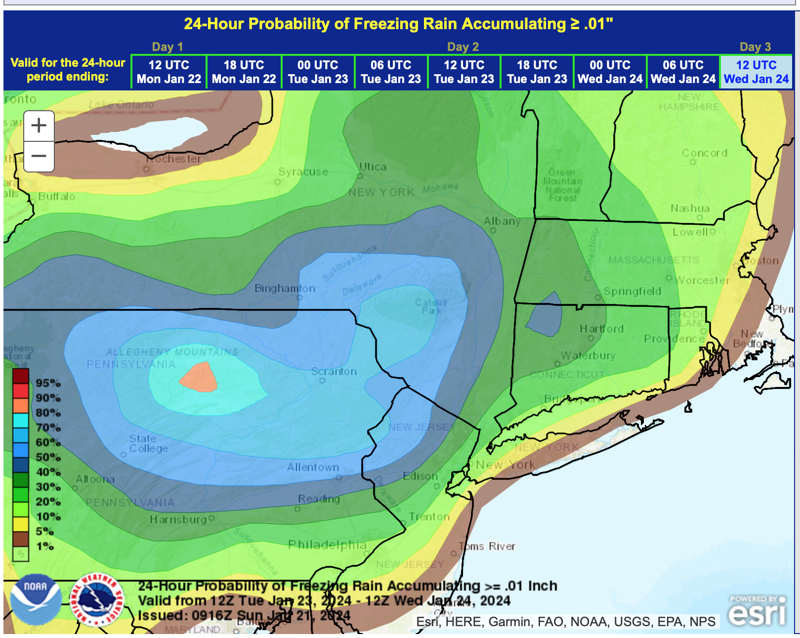
Yes... but northern stream seems to deflect some of the warmth south at times next week in the Northeast USA. . EPS has an interesting ice signal next Tuesday night ne PA-se NYS with at least two of the global ensembles 1-4" snow I90 north.
-
2
-
3
-
-
NY subforum thread considerations: Sunday the 28th-Wednesday the 31st: One or possibly two hazardous wintry events of snow and/or ice or flooding qpf. Just too far away to have much consensus although for now, most of the snow ice is ensembled inland from I95, despite some op members on the coast.
My interest is combined with additional qpf by the end of the Jan adding up to between 1-2.5". If its only 1", Allentown will be top 10 rainfall in January 100 years record keeping. Allentown already top 1/3rd of monthly snowfall. Allentown is western fringe of the subforum but gives an idea of distant interior.
Ensembles already have a small chance of a few small streams "minor" flooding by next weekend (I consider small stream minor flooding somewhat routine-as opposed to mainstem minor which is less frequent and a bigger deal) with snow melt, qpf and that does not take into account potential qpf beyond the 28th.
No action on my part for a day or three.
-
1
-
-
11 hours ago, kdennis78 said:
2" QPF over last part of January- Is that a total or are we gonna get a series of coastal and cutter storms that are going to overwhelm us living on saturated ground?
I haven't looked close, but I think its going to be messy wintry west of I95 starting later next weekend, despite above normal temps (colder part of winter). So yes, we could get to 60F mid or late workweek--- see attached ensemble temps for central NJ We should lose all the snow south of I80 by next weekend. North of I80 it gets complicated by ice. Minor flooding could result on a few small streams by next weekend??? but nothing like we had in early January. Its the following week (late Sunday the 28th-31st) that I think gets interesting regarding all sorts of possibilities.
-
1
-
1
-
-
11 hours ago, Picard said:
We made it to 1.5" in Sparta. Been pleasantly surprised with a little burst this evening - even though there isn't much on radar. I was just out, roads are slick in spots, caution is warranted. In fact, it's still snowing some, and I can see both the moon and Venus breaking through.
Yep--I picked up almost an inch between 430-6P. final here in this part of Wantage 2.5. I see most of northern SC 2+.
-
2
-
-
45 minutes ago, donsutherland1 said:
That came out a short time ago. The 0.1” was the 1 pm figure.
Don and others... any pix from the vicinity. What I saw on TV 4 in CP was more than 0.4".
-
I will follow up with some storm totals tomorrow near 10AM
I hope most can enjoy in what has been a good winter week of cold and snow on the ground.
-
2
-
-
1 hour ago, NorthShoreWx said:
Just noticed a broken line of snow showers moving south from just south of ALB and I-88 to near Scranton. Wind shift/arctic boundary?
Probably.. our dewpoint right now at 630P iOS still 19 so may wring out some more snow. Had a pretty good rate of fluff accum 430-6P. Now at 2.5" It is beautiful here.
I saw some CP pix on TV and 0.1 is incorrect in CP. My take is that there was at least 0.5" in CP based on what I saw... maybe more. I saw the .04 w.e at CP and 0.1" snowfall in the 4P CLI. Something isn't right with a max of 32 at CP.
-
2
-
-
Wantage at least 1.6" at 3P and snowing again pretty steady at 430P. Walt
-
Wantage NJ at 740' MSL 1.3". mostly small flake snow, and definitely smaller flakes right now than a while ago. All roads salted enough to be mainly wet with a few slushy spots. Market parking lots snow covered off of wet SR13 in Sparta. Temp in Wantage 24F.
-
4
-
-
Reports...widespred 3-4" already DC-BWI and am seeing 2-3" just west of PHl and reports of 1/2 mile moderate snow Trenton and Mount Pocono which is art least 1/2"/hr if it holds for an hour. Snow looks better to me today then it did Tuesday. Still disorganized but there should be a nice consolidation during midday according to a number of short fuse models. 0.2" at 835AM in this Wantage location since it began at 715A. Flakes still a little too small so its dense power at 21F.
-
5
-
-
Tiny flakes Sussex County NJ. Need bigger flakes to get decent snowfall
-
2
-
-
No more threads anticipated in January with ice-snow next week probably I84 corridor northward.
Monitoring for 2+" qpf the last 10 days of the month pushing us up toward top 10 January prep and also renewed minor flooding in NJ but looong ways off to be sure.
Focus today on whatever occurs in the snow thread. I sure hope Feb produces.
Looks somewhat favorable to me. EC weeklies dated the 18th are focusing in on the traditional Feb 5-15 period. Fingers crossed.
-
3
-
2
-
-
moderate snow 1/2mile through a fair amount of the Baltimore area now, and widespread 1-2 mi northern PA.
-
2
-
-
flurries down in Mt Olive NJ... wont be long. Could be a slight break for an hour 2 around 9AM near I80 but it will refire.
-
1
-
-
2 minutes ago, MANDA said:
NJ state of emergency!? WTH
They have a difficult time targeting one area since people commutes 50 miles from a adverse zone to a safer zone so the whole state. There's no doubt in mind souther nNJ is going to have a nice snowstorm today of potential 6-7"... bigger flakes, a little ocean instability contribution below 850 MB (a bit of ocean effect may get up to Monmouth Cty and s shore LI) and occasional banding.
I could see banding up to between I78-I80, especially near 3PM when the nw upper level flow ij. NYS impinges on NJ way flow above 850 MB forcing convergence in the 800-600MB layer that is saturated. We'll see what happens.
-
4
-
-
5 minutes ago, Volcanic Winter said:
Thank you Walt. Do you have any thoughts on where the NWS is getting their aggressive forecast from? Are they banking on high ratios or expect over performance? They must see something to issue the numbers they did.
Just checked again and northeast NJ in the teal section of your map is still showing a forecast of 2-3 inches, as one example.
Mainly just curious if you have a read on this. Thanks for your time as always!
Well, I haven't read their AFD's - no time since I have my own private group that once/day at 530A. Their AFD should haver some insight. I'll check now. Attaching the first reports of 1+.
-
2
-
-
A possible statistical 3AM reality check. Chance of snow exceeding 1". Brown starts 80%. I think where its brown, is also a very good chance of 2+. The rest is yours to debate. It should snow an inch into Fairfield Litchfield counties. maybe spotty 2"?
-
1
-
2
-
-
11 hours ago, LibertyBell said:
any reports from the Poconos, Walt?
did not check... had to be less than 0.3"
-
1
-


Interior NW & NE Burbs 2024
in New York City Metro
Posted
Everything posted at about 7AM looks pretty much in line with our new daytime modeling (12z/21 HRRR, RGEM and NAM). Think its going to get slippery pretty quick on Tuesday I84 corridor, especially afternoon-evening. Lets see if modeling holds onto the ONSET speed of sleet to snow during the daylight hours Tuesday. This may be threaded late today or tomorrow morning as it looks pretty good to get down to I80--- not quite 100% yet on I80 but am 80% sure. Thread pending updated 12z ensemble guidance.