

wdrag
-
Posts
4,409 -
Joined
-
Last visited
Content Type
Profiles
Blogs
Forums
American Weather
Media Demo
Store
Gallery
Posts posted by wdrag
-
-
On 2/7/2024 at 12:53 PM, RU848789 said:
I do have IM but may not have set up on American.
-
 1
1
-
-
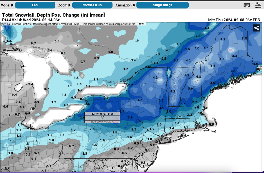
06z/8 EPS + snow depth change... warrants continued restraint on expectations I80 NYC LI. Click for clarity..
-
1
-
 1
1
-
-
Focusing on single op cycles vs ensembles is a probable mistake.
Consensus continues north of us for all global models snowfall so far. That's why there is no enthusiasm. Realistic is the way to go.
Generally need Nov-Dec snow to have a good winter as posted earlier. Stats support.
I hope we're not cooked, even out here in extreme nw NJ. Maybe the stats will add outlier sample of decent NYC snow by seasons end?
Back tonight.
-
7
-
1
-
-
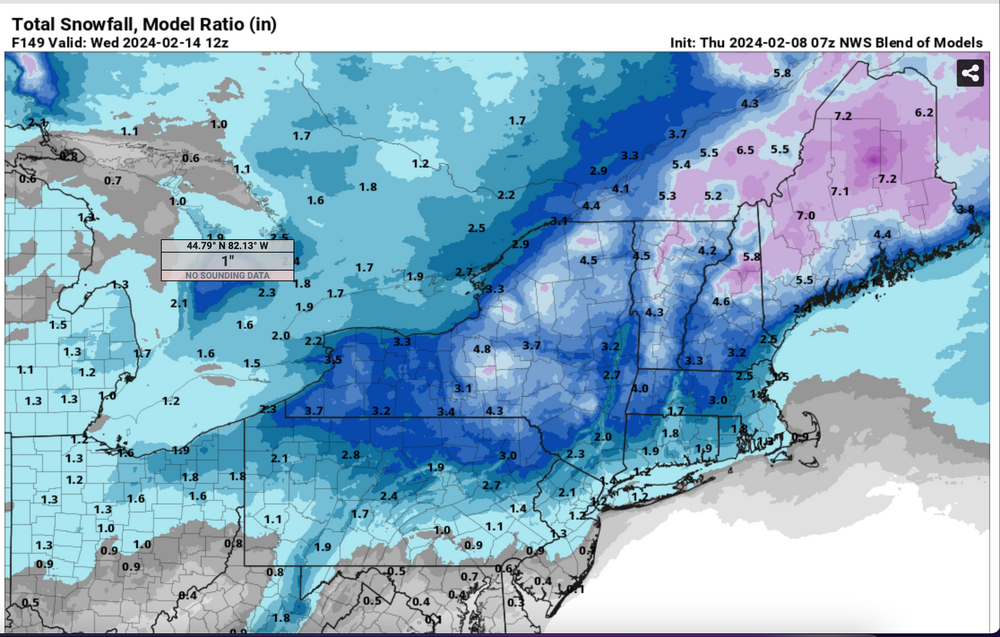
No thread this morning: Modeling overall says I84 is more or less the south boundary of 1-2" of snow.
Ensembles via the GEFS have less than 45% of 1" of snow in 48 hour period NYC early next week.
I added the NBM from 07z/8 through Valentines Day: I can't thread anything and am not upbeat about a winter thread for a while. I think it a good idea to wait for another 12-48 hours before any thread. Wish I could be more enthusiastic. I'll check back tonight.
-
8
-
-
Right now, I can't start a thread for NYC-LI 1/2-4" snowfall 2/13 ish cause 19z NBOM and positive snow depth change on the latest 12z CMCE/EPS and 18z GEFS are all less than 2". Too risky for a loser thread.
Wind gusts right now are ensembled 40-45 MPH which is marginal wind advisory and a day of OBS thread.
If ensembles grow together on snowfall for I80 region we'll get it going but for now, at least from myself, I cannot confidently proclaim we'll get 2" at CP for either the 13th or 18th-19th. I hope this changes.
The 13th event looks to me like north of I84, probably best snowfall north of I90.
NAVGEM may be a best fit? Certainly the ensembles are not optimistic for I80 area
This can adjust since we' re still talking D6-7. Back tomorrow morning. Best to all. Walt
-
3
-
2
-
-
No time to look but on wind.
All should be aware that CPC has had us in a slight chance of a big wind event 14th-roughly 18th. Just go to CPC hazards and the probabilistic elements and you’ll see wind flagged in the northeast.
If we eventually thread something it might be primarily damaging wind In any case I can’t look closely til 630pm
-
2
-
-
1 hour ago, RU848789 said:
Same with OSHA chemical incident investigations/reports (they're similar to the NTSB reports conceptually), which was my field when I was working at Merck, having been the director of the group responsible for chemical process safety testing and evaluations for new processes progressing through R&D and eventually going to manufacturing sites (if a new drug was successful). After action reviews, done well, can be eye opening to pre-incident errors in systems, judgment and analysis, often revealing biases and lack of attention to detail from key actors in these incidents and we used them liberally as teaching tools in trying to ensure that our staffs doing the testing and evaluations weren't subject to bias and/or overlooking key factors. We didn't have any significant incidents during that time, fortunately.
Excellent and well stated! Anyone can start a thread but I prefer to start those that have a better assurance of at least half the subforum accurate verification for a long lead time.
-
2
-
-
One error on sigh and composure- ensembles... The CNN voice is between aircraft and Air Traffic Control. The Cockpit Voice Recorder which I think holds 2 or more hours of sound was overwritten, which must be some sort of airline/FAA procedural oversight on saving that data. Still, it's instructive.
Let's go snow!
-
Also, I think there is a lot to learn from NTSB aircraft incident reports...the way they are investigated, written, referenced.
-
2 minutes ago, NEG NAO said:
I hope you are not referring to me at almost 69 years of age..........I am just a grouchy old man........
No specific reference; It's a forum. I get excited too, but too many failures direct me to restrain my spoken thoughts. For now, I dont know exactly what is ahead except it's worthy to monitor but for a wider area than just our NYC subforum. For sure, this future is looking a little better than December.
-
2
-
-
For those who want a big one that is less Thread the Needle so to speak, I like a big upper low formed off DE traveling out to the bench mark, having been formed from short waves diving se from the upper midwest and joining forces with a southern streamer and timing out to our south. Those are the ones with large areal deep snows, plenty of 850MB easterly flow (50kt) and presumably cold enough surface high to the north.
This one coming up doesn't look like that... it has hope if the latitude can be us. I'm sure 3+ between I80 and Montreal as is WPC via their implied D6-7 in their 10% two days of 3+ in the northeast. For now, it's not worth a thread for me.
-
1
-
-
Sigh... Can I ask to lower excitement. Think of yourselves in the cockpit of a 737 and you blow out a door. Composure wins... good learning experience for those up and coming in life to maintain vigilance, follow procedures and ensembled guidance for a safer approach both work and family, an approach that can be at least a partial win for the large adjunct Atlantic Ocean subforum and subsequently a more positive outcome. Yesterdays CNN has details of the Cockpit Voice Recorder on how that 737 door incident was handled. Calm-procedural. For me that will have to be ensembled and remember the Canadian has to have it (my relearned lesson AGAIN the past failed thread)
Modeling for the 06z/7 GFS op doesn't fit the ensembled short wave scenario (intensity and therefor big dump in a few hours). If the resulting storm is weaker, less advection fields, less lift, etc etc. Give this a chance. Ptype and T at D6 can be a little shaky and for snow, its a fine line, as we all know.
On snow depth: That's all that was available for the smaller geography shown but we have none now, so consider that a start for adding some snow. Back tonight.
-
7
-
1
-
-
Just now, wdrag said:
CMCE and EPS Positive Snow Depth change under 1" NYC, but 10 to 1 EPS does have 2-3 as the GEFS.
If the models were that good at 6-7 days nailing Ptype/Temp, wow. But they're not--just the idea that event is coming to the northeast USA.
Think we can wait before stirring more certainty.
Will revisit at 530PM and then, if good, all the ensemble guidance for this event will post plus BOM which is under 1.5" or less NYC and LI -07Z version.
-
CMCE and EPS Positive Snow Depth change under 1" NYC, but 10 to 1 EPS does have 2-3 as the GEFS.
If the models were that good at 6-7 days nailing Ptype/Temp, wow. But they're not--just the idea that event is coming to the northeast USA.
Think we can wait before stirring more certainty.
-
2
-
-
GEFS 10 to 1 has 2" NYC but Positive Snow Depth Change under 1". Think it best to wait til 630PM ish this evening, rather than chase something that is 1" or less this far out. Has some hope.

-
1
-
-
Will look at this closely for a thread, if NYC can show 2+ on the 06z GEFS... for now, think I'd ;like to wait til this evening. It is 6 days out.
-
1
-
-
32 minutes ago, NEG NAO said:
What is your definition of " a decent megalopolis snowstorm this winter" ?????
My call 6+. His call I dont know, but I do know that we're not talking 1-3" climo.
-
2
-
-
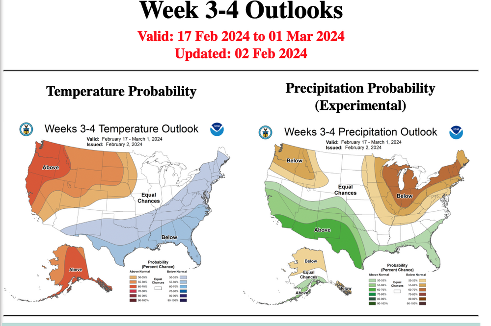
Regarding winter prospects last two weeks of Feb. CPC Friday week 3-4 (appended) and Tomer mirror each other, drier and cooler than normal here. It's ensemble guidance and imperfect. A bump north and we're good as Bluewave mentioned.
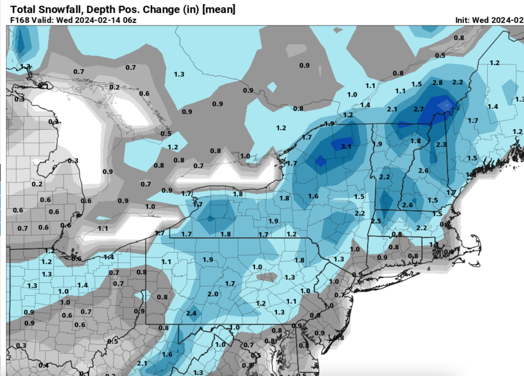
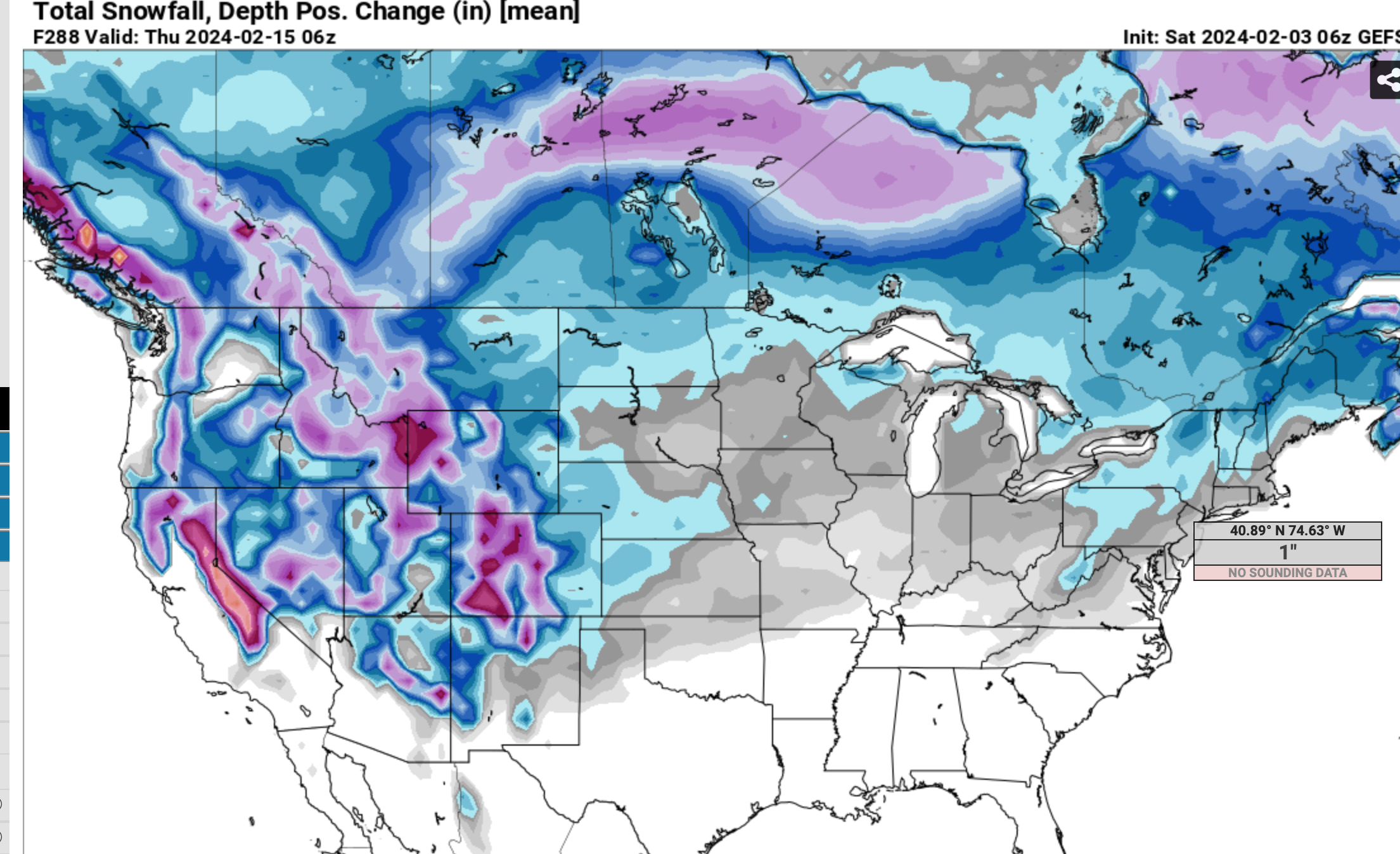
My problem: the D8-14 from the NAEFS still has us warmer than normal 11th-18th., albeit attempting to cool around the 14th and after. So what? Cause, the 06z/3 GEFS 24 snow depth change appended here, shows what we may be suspecting. Elevation dependent snow snowfall is more prominent and inland (climo?). Think it might take a while to rid ourselves of the modified Pacific airmass which at this point in my mind doesn't bode well for NYC/LI. At least the SST's are near normal.
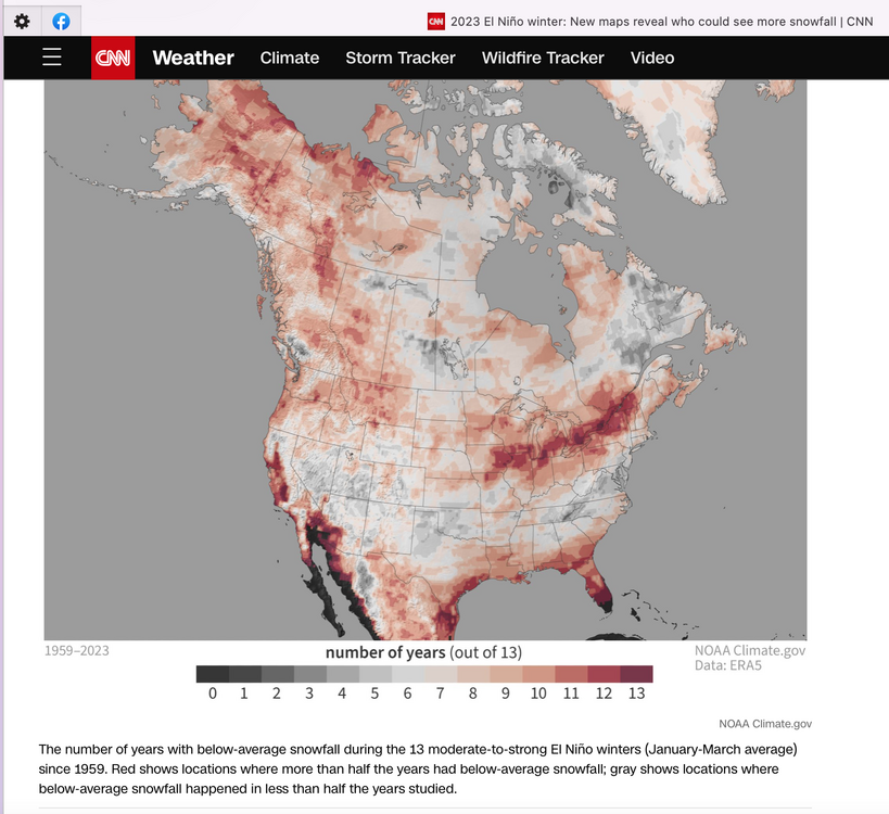
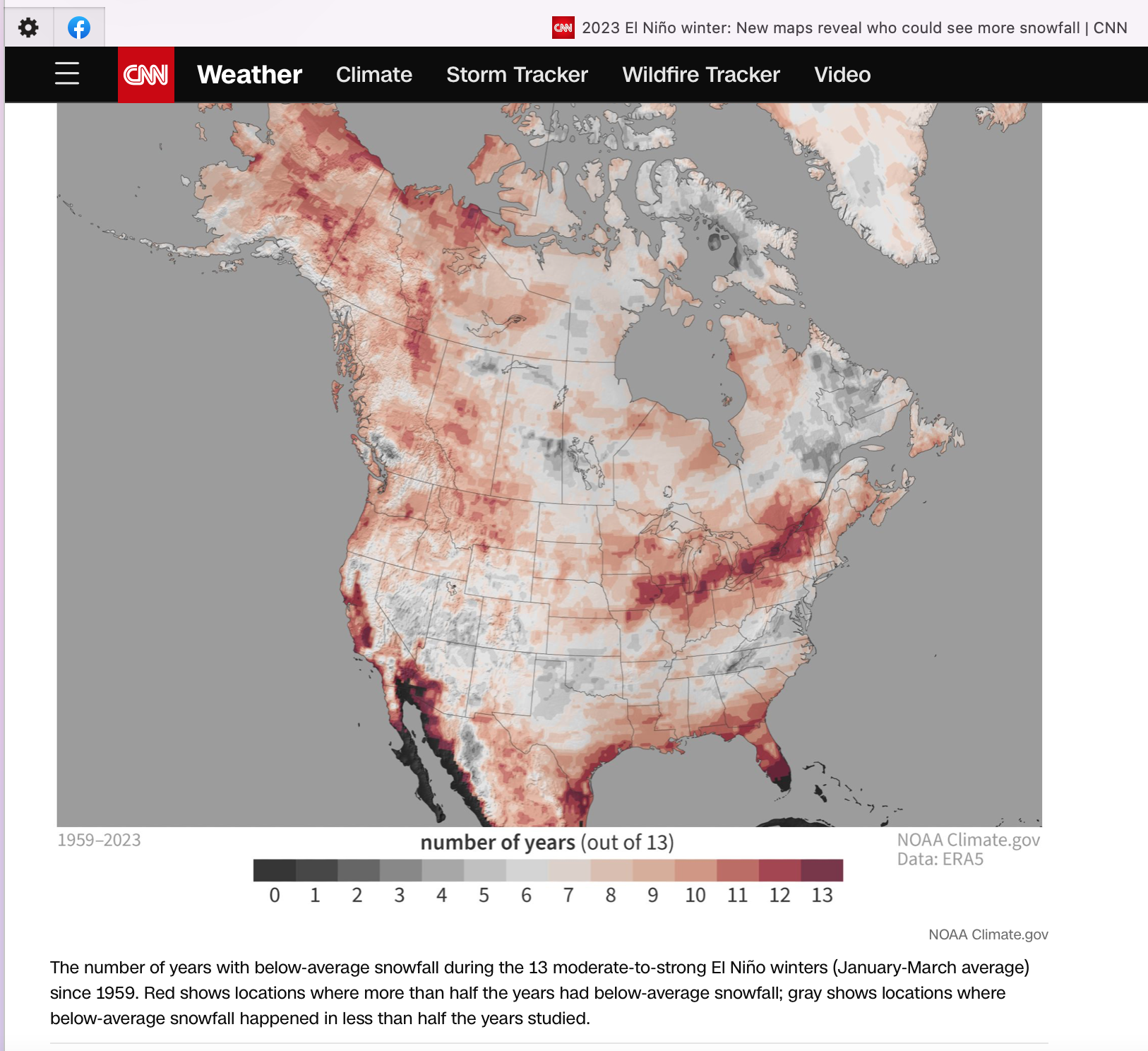
So my hope for this pattern to produce continues, in part due to the more favorable 5H structure, in part due to a reliable long ranger that likes the option for a decent megalopolis snowstorm this winter- (communications since last summer), and in part due to what I see is the verifying CNN story Dec 2 post, appended. I just need to live well outside of weather, prior to something budding favorably.
If interested-click the graphics for a little more clarity.

-
5
-
-
Update the initial Jan thread with monthly verification and comments.


-
1
-
-
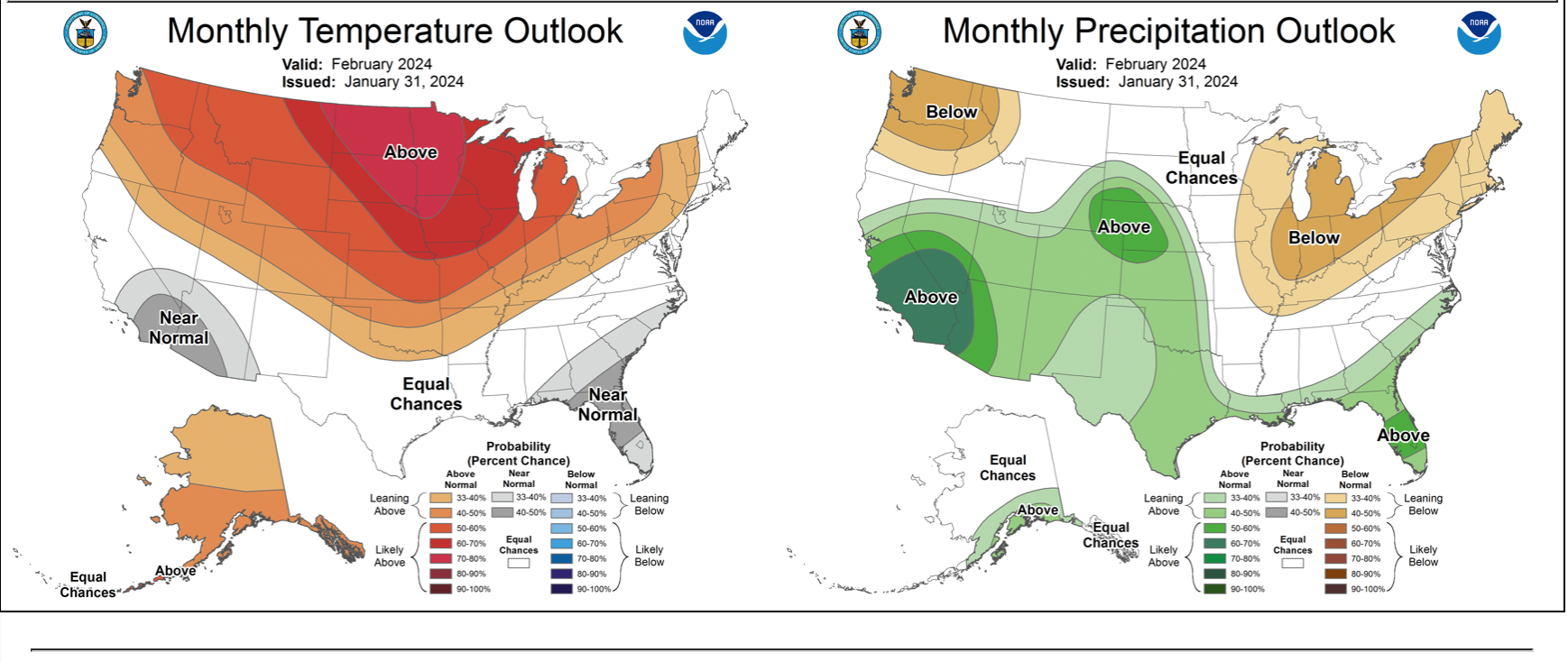
fwiw..I added the CPC updated Feb outlook from Jan 31 to the initial thread so we can look back.

-
3
-
-
5 hours ago, GaWx said:
Don and others,
I counted 16 strong El Niño winters back to 1877-8. Of those, 5 (31%) had their coldest of the winter at NYC 2/16-24:
1. 1889: lows of 5 on 2/23 and 3 on 2/24 vs coldest of 9 earlier (2/20-6 coldest week of winter at 24)
2. 1903: low of 4 on 2/19 vs coldest of 8 earlier (2/16-22 coldest week of winter at 21)
3. 1930: low of 7 on 2/16 and 2/17 vs coldest of 10 earlier
4. 1958: low of 6 on 2/17 and 3 on 2/18 vs coldest of 12 earlier (2/13-19 coldest week of winter at 17)
5. 1973: low of 7 on 2/17 vs coldest of 8 earlier
With the coldest so far this winter being only down to 17 and with the colder pattern being predicted in the longer range, I’d think there’d be a good shot at getting the coldest of the winter 2/16-24. I realize getting below 10 will of course be a significant challenge considering the warmer climate. But with it getting down to 3 on 2/18/1958, I’d think a 9 in 2024 wouldn’t be a shocker.
The coldest week so far this winter is 25.4 (1/15-21). A colder week later this month wouldn’t be easy but I don’t think it would be too surprising.helps if we have snow cover for the colder period... presume all saw the new weeklies issued today (is the hope going to verify in our favor later Feb-early March?)
-
3
-
-
8 hours ago, MJO812 said:
Of course
Smh
Unfortunately, in the end I like the Canadian with snow, otherwise.
I sure hope we can get something those last two weeks of Feb.
-
1
-
-
Unlikely 12z/31 NAM solution for nearby NYC snow Thu night-Fri morning. Not on the 06z Canadian RGEM, nor on 00z/31 GEFS/CMCE ensembles. Doesn't mean it can't happen but my guess is that there will be above freezing layers aloft to make this wet NYC, icy w - n suburbs if its nearly this extensive.
-
1
-
 1
1
-
-
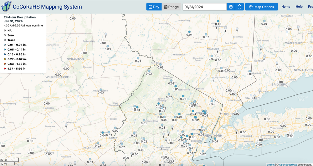
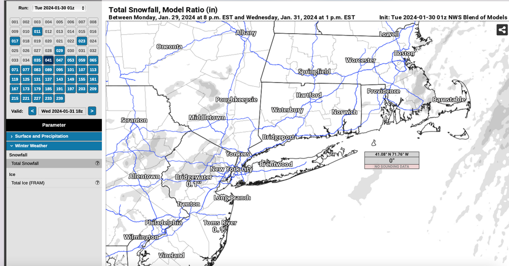
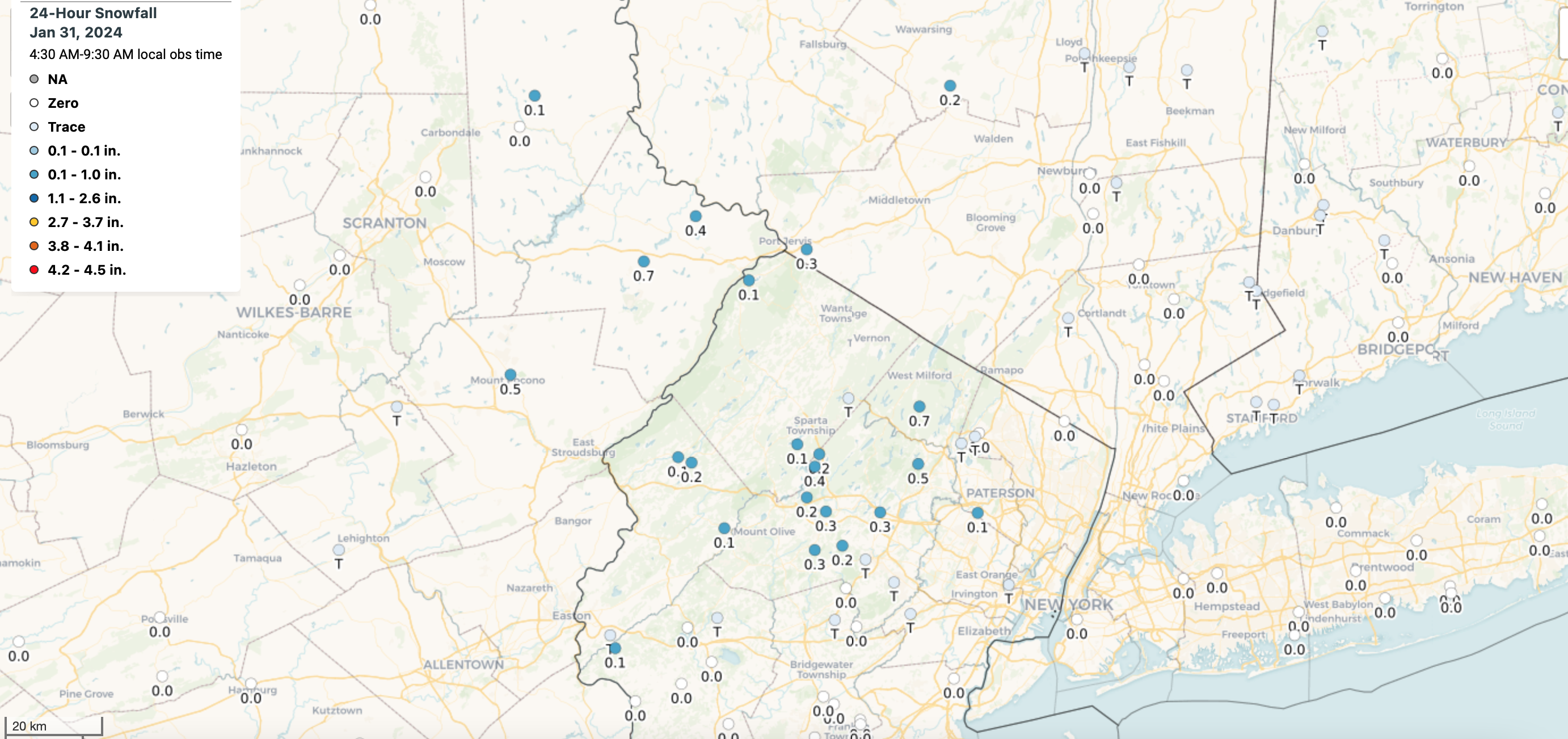
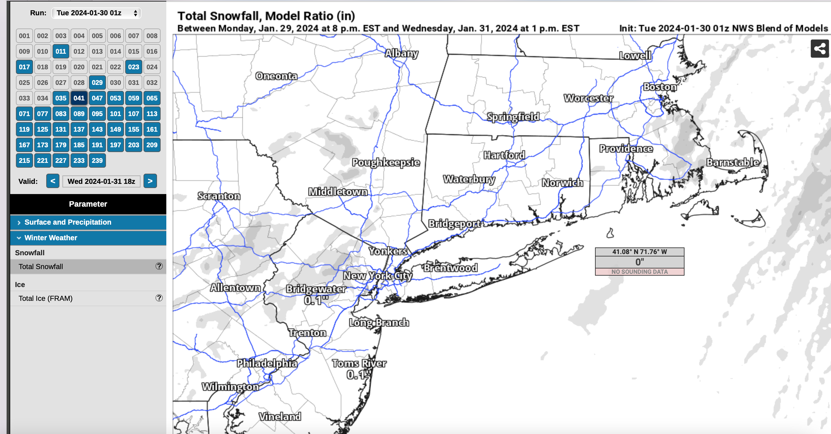
And the winnah... the NAM and GFS (USA modeling) and Canadian as well vs the nil ECMWF. Shallow RH, weak lift and here's the results. I also added the NBM from 8PM the 29th which had a touch but am sure it was diminished by the nil EC. Also, I don't think it captured elevated slightly heavier small flake snowfall.
imo, no model can be disparaged every time... I don't. Sometimes frustration-yes! and the NBM is imperfect but a nice starting point,
Here's the melted water equiv and snowfall from CoCoRaHs overnight.
Please click for your clarity if you wish

-
2
-


February 2024
in New York City Metro
Posted
Will review carefully this eve and possibly start a thread but need some acc NYC. Am on the road now so won’t know on a thread til 9pm. Just keep Monitoring on this Feb thread.
NYC due for another 1-3 since it’s only had one of the normal 3 per winter. Thanks Don