

bluewave
-
Posts
31,655 -
Joined
-
Last visited
Content Type
Profiles
Blogs
Forums
American Weather
Media Demo
Store
Gallery
Posts posted by bluewave
-
-
4 hours ago, Typhoon Tip said:
Nah... not to sound dismissive (ha) really but that doesn't explain why both air and sea from pole to pole unilaterally increased prior to the onset of the warm ENSO phase.
The timing of the jump in temperatures this year was related to the onset of the El Niño. But the magnitude of warmth was a function of the record heat being released from the oceans. Much more heat available this El Niño than previous ones. So even a significantly weaker El Niño than 2015-16 had more warming potential. But it will still take more research specifically as to why this lead to a sharper temperature increase earlier in the year than past El Niño events.
-
 1
1
-
 1
1
-
-
My guess is that this warming spike is related to the rapid subtropical SST warming which has occurred since the last super El Niño in 15-16.
https://www.nature.com/articles/s43247-023-00839-w
In this study, we evaluate the ocean warming pattern derived from four decades of satellite measurements. We find widespread strong subtropical ocean warming, concentrating mostly on the western ocean basins. In contrast to these observations, studies of paleoclimate suggest that the greatest ocean warming occurs at higher latitudes. By pairing the observed warming pattern with SST evolution in long-term climate simulations, we propose that the observed warming pattern is constrained by ocean dynamics of surface convergence (downwelling, subtropical gyres) and divergence (upwelling, subpolar gyres) rather than being dominated by internal variabilities, such as the PDO. This pattern emerges only at the early stage (a few decades) of anthropogenic warming when absorption of heat concentrates in the upper ocean. On centennial (for the Northern Pacific Ocean) to millennial (for the North Atlantic Ocean and Southern Hemisphere) timescales, when deep ocean water warms, the greatest ocean warming is expected to occur in the subpolar region, as indicated by paleo-reconstructions and the long-term and equilibrium climate simulations. -
Extremely steep lapse rates and some CAPE should allow for gusts over 40 and small hail with the convection later today.

-
2
-
-
In general, the 2023 temperature anomaly has come out of the blue, revealing an unprecedented knowledge gap perhaps for the first time since about 40 years ago, when satellite data began offering modellers an unparalleled, real-time view of Earth’s climate system. If the anomaly does not stabilize by August — a reasonable expectation based on previous El Niño events — then the world will be in uncharted territory. It could imply that a warming planet is already fundamentally altering how the climate system operates, much sooner than scientists had anticipated. It could also mean that statistical inferences based on past events are less reliable than we thought, adding more uncertainty to seasonal predictions of droughts and rainfall patterns.
Much of the world’s climate is driven by intricate, long-distance links — known as teleconnections — fuelled by sea and atmospheric currents. If their behaviour is in flux or markedly diverging from previous observations, we need to know about such changes in real time. We need answers for why 2023 turned out to be the warmest year in possibly the past 100,000 years. And we need them quickly.
Nature 627, 467 (2024)
doi: https://doi.org/10.1038/d41586-024-00816-z
-
1
-
1
-
-
12 hours ago, WX-PA said:
Lol..the late 80's and 90's were warm and snowless..2 good winters in 14 years. We are going through the same thing now after the great winters of 2002-2016, weather changes..that's how you get averages with climate.Climate might be changing and warming but it doesn't mean that's it for snow and cold which I think you were implying.
The 1980s and 1990s were no comparison to the warmth and lack of snow during the 2020s so far. I will use LGA stats to compare since NYC has been consistently undermeasuring snowfall. While we are only half way through the 2020s, we would need a significant cool down and snowfall increase next 5 years to avoid the warmest and least snowiest decade on record.
If global and local temperatures continue rising at the same rate, then we will eventually have a whole decade with the average snowfall under 10” and the average winter temperature over 40.0°.
LGA 2020s so far snowfall average….15.8”….DJF ave temp…39.2°
………1990s………..27.1”………………………….36.7°
………1980s………..21.0”…………………………34.5°
-
1
-
 1
1
-
-
44 minutes ago, snowman19 said:
@Bluewave @donsutherland1 Here is why all the stratospheric and SSWE hype failed all winter long. There is no denying that we are in the midst of major climate change/AGW anymore. We have to start rethinking the way we forecast long range winter outlooks
Yeah, it would be interesting to see specifically which aspect of the warming in the system lead to this outcome. Notice the extreme volatility of the AO between positive and negative. Maybe the IO to WPAC MJO driven Rossby wave train competing with the El Niño was interfering with the coupling. So every drop of the -AO was answered by and quick increase.

-
3
-
1
-
-
24 minutes ago, jm1220 said:
Who needs south shore beaches anymore anyways? This one if it sits for a couple days might be a TKO.
Yeah, beach erosion and coastal flooding have become the new normal with the more extreme storms and rising sea levels.
-
1 hour ago, Brian5671 said:
Euro and CMC are very wet just off the coast-with the usual correction N and W we could get a ton of rain
Much more model spread than we typically see around 5 days out. The potential for heavy rains is there if everything gels. But this is a lower confidence forecast than usual since cutoffs in spring are the hardest for models to resolve. Each model has a different low position at 120 hrs.


-
1
-
-
59 minutes ago, Brian5671 said:
Nice for ski country but too late as some are already closed
They did much better last March with the -NAO and record MJO 8.


-
1
-
-
Gorgeous photos of the roll clouds on the South Shore yesterday.

-
2
-
-
It’s the areas that sustain a hard freeze in the mid 20s that are most susceptible to plant damage after an early bloom.
Question:A hard freeze in early spring damaged the newly emerged growth on several trees and shrubs. Will the plants recover?
Answer:Newly emerged tree and shrub foliage is susceptible to damage from below freezing temperatures. The new growth on many trees and shrubs can tolerate temperatures in the low 30s and upper 20s. Freeze damage is most likely when temperatures drop into the middle 20s or below. Symptoms of freeze damage include shriveling and browning or blackening of damaged tissue. Damaged growth usually becomes limp. Eventually, damaged or destroyed leaves drop from the tree or shrub.
Fortunately, trees and shrubs have the ability to leaf out again if the initial growth is damaged or destroyed. Damaged trees and shrubs have only suffered a temporary setback. Healthy, well established trees and shrubs will produce additional growth within a few weeks. Good care during the remainder of the year, such as watering during dry periods, should aid the recovery of trees and shrubs planted within the past two or three years.
-
The Seattle forecast zones actually got to 80° before our area this March.
-
1
-
-
2 hours ago, LibertyBell said:
no, winter is actually now two months long-- January and February.
Yeah, March was more like a winter month during the 2010s and now it’s a spring month in the 2020s. So it’s a challenge reaching normal seasonal snowfall when we don’t get much snow these days in December and March since they have become so warm. Very hard to get to normal when you are just relying on January and February. Plus the warmth has been encroaching on those months also reducing snowfall potential. So a continuation of our climate becoming more like what areas to our south in the Mid-Atlantic used to be like in the old days.
-
2
-
 1
1
-
-
NYC will need to see some snowfall improvement the next 5 years for the 2020s to avoid being the lowest snowfall decade following the highest during the 2010s since 1950.
Monthly Total Snowfall for NY CITY CENTRAL PARK, NY
Click column heading to sort ascending, click again to sort descending.YearOctNovDecJanFebMarAprSeasonMean 0.0 T 2.6 4.4 7.1 0.1 T 14.2 2023-2024 0.0 T T 2.3 5.2 T M 7.5 2022-2023 0.0 0.0 T T 2.2 0.1 0.0 2.3 2021-2022 0.0 T 0.2 15.3 2.0 0.4 0.0 17.9 2020-2021 0.0 0.0 10.5 2.1 26.0 T 0.0 38.6 2019-2020 0.0 0.0 2.5 2.3 T T T 4.8
Monthly Total Snowfall for NY CITY CENTRAL PARK, NY
Click column heading to sort ascending, click again to sort descending.YearOctNovDecJanFebMarAprSeasonMean 0.3 1.1 5.3 12.9 11.8 6.0 0.6 37.9 2018-2019 0.0 6.4 T 1.1 2.6 10.4 0.0 20.5 2017-2018 0.0 T 7.7 11.2 4.9 11.6 5.5 40.9 2016-2017 0.0 T 3.2 7.9 9.4 9.7 0.0 30.2 2015-2016 0.0 0.0 T 27.9 4.0 0.9 T 32.8 2014-2015 0.0 0.2 1.0 16.9 13.6 18.6 0.0 50.3 2013-2014 0.0 T 8.6 19.7 29.0 0.1 T 57.4 2012-2013 0.0 4.7 0.4 1.5 12.2 7.3 0.0 26.1 2011-2012 2.9 0.0 0.0 4.3 0.2 0.0 0.0 7.4 2010-2011 0.0 T 20.1 36.0 4.8 1.0 T 61.9 2009-2010 0.0 0.0 12.4 2.1 36.9 T 0.0 51.4
Monthly Total Snowfall for NY CITY CENTRAL PARK, NY
Click column heading to sort ascending, click again to sort descending.YearOctNovDecJanFebMarAprSeasonMean T T 6.6 7.2 10.1 3.5 0.5 28.0 2008-2009 0.0 T 6.0 9.0 4.3 8.3 T 27.6 2007-2008 0.0 T 2.9 T 9.0 T 0.0 11.9 2006-2007 0.0 0.0 0.0 2.6 3.8 6.0 T 12.4 2005-2006 0.0 T 9.7 2.0 26.9 1.3 0.1 40.0 2004-2005 0.0 T 3.0 15.3 15.8 6.9 0.0 41.0 2003-2004 0.0 0.0 19.8 17.3 0.7 4.8 0.0 42.6 2002-2003 T T 11.0 4.7 26.1 3.5 4.0 49.3 2001-2002 0.0 0.0 T 3.5 T T T 3.5 2000-2001 T 0.0 13.4 8.3 9.5 3.8 0.0 35.0 1999-2000 0.0 0.0 T 9.5 5.2 0.4 1.2 16.3
Monthly Total Snowfall for NY CITY CENTRAL PARK, NY
Click column heading to sort ascending, click again to sort descending.YearOctNovDecJanFebMarAprSeasonMean 0.0 0.8 3.0 6.1 8.7 5.7 0.1 24.4 1998-1999 0.0 0.0 2.0 4.5 1.7 4.5 0.0 12.7 1997-1998 0.0 T T 0.5 0.0 5.0 0.0 5.5 1996-1997 0.0 0.1 T 4.4 3.8 1.7 T 10.0 1995-1996 0.0 2.9 11.5 26.1 21.2 13.2 0.7 75.6 1994-1995 0.0 T T 0.2 11.6 T T 11.8 1993-1994 0.0 T 6.9 12.0 26.4 8.1 0.0 53.4 1992-1993 0.0 0.0 0.4 1.5 10.7 11.9 0.0 24.5 1991-1992 0.0 T 0.7 1.5 1.0 9.4 T 12.6 1990-1991 0.0 0.0 7.2 8.4 9.1 0.2 0.0 24.9 1989-1990 0.0 4.7 1.4 1.8 1.8 3.1 0.6 13.4
Monthly Total Snowfall for NY CITY CENTRAL PARK, NY
Click column heading to sort ascending, click again to sort descending.YearOctNovDecJanFebMarAprSeasonMean T 0.1 2.3 7.9 5.4 3.0 1.0 19.7 1988-1989 0.0 0.0 0.3 5.0 0.3 2.5 0.0 8.1 1987-1988 0.0 1.1 2.6 13.9 1.5 T 0.0 19.1 1986-1987 0.0 T 0.6 13.6 7.0 1.9 0.0 23.1 1985-1986 0.0 T 0.9 2.2 9.9 T T 13.0 1984-1985 0.0 T 5.5 8.4 10.0 0.2 T 24.1 1983-1984 0.0 T 1.6 11.7 0.2 11.9 0.0 25.4 1982-1983 0.0 0.0 3.0 1.9 21.5 T 0.8 27.2 1981-1982 0.0 0.0 2.1 11.8 0.4 0.7 9.6 24.6 1980-1981 0.0 T 2.8 8.0 T 8.6 0.0 19.4 1979-1980 T 0.0 3.5 2.0 2.7 4.6 T 12.8
Monthly Total Snowfall for NY CITY CENTRAL PARK, NY
Click column heading to sort ascending, click again to sort descending.YearOctNovDecJanFebMarAprSeasonMean T 0.3 2.0 8.0 9.9 2.3 0.1 22.5 1978-1979 0.0 2.2 0.5 6.6 20.1 T T 29.4 1977-1978 0.0 0.2 0.4 20.3 23.0 6.8 T 50.7 1976-1977 0.0 T 5.1 13.0 5.8 0.6 T 24.5 1975-1976 0.0 T 2.3 5.6 5.0 4.4 T 17.3 1974-1975 0.0 0.1 0.1 2.0 10.6 0.3 T 13.1 1973-1974 0.0 0.0 2.8 7.8 9.4 3.2 0.3 23.5 1972-1973 T T T 1.8 0.8 0.2 T 2.8 1971-1972 0.0 T T 2.8 17.8 2.3 T 22.9 1970-1971 0.0 0.0 2.4 11.4 T 1.3 0.4 15.5 1969-1970 0.0 T 6.8 8.4 6.4 4.0 T 25.6
Monthly Total Snowfall for NY CITY CENTRAL PARK, NY
Click column heading to sort ascending, click again to sort descending.YearOctNovDecJanFebMarAprSeasonMean T 0.4 8.3 7.1 10.1 6.1 0.1 32.0 1968-1969 0.0 T 7.0 1.0 16.6 5.6 0.0 30.2 1967-1968 0.0 3.2 5.5 3.6 1.1 6.1 0.0 19.5 1966-1967 0.0 0.0 9.1 1.4 23.6 17.4 T 51.5 1965-1966 T 0.0 T 11.6 9.8 T 0.0 21.4 1964-1965 0.0 0.0 3.1 14.8 2.5 2.8 1.2 24.4 1963-1964 0.0 T 11.3 13.3 14.1 6.0 T 44.7 1962-1963 T T 4.5 5.3 3.7 2.8 T 16.3 1961-1962 0.0 T 7.7 0.6 9.6 0.2 T 18.1 1960-1961 T 0.0 18.6 16.7 18.2 1.2 T 54.7 1959-1960 0.0 0.5 15.8 2.5 1.9 18.5 0.0 39.2
Monthly Total Snowfall for NY CITY CENTRAL PARK, NY
Click column heading to sort ascending, click again to sort descending.YearOctNovDecJanFebMarAprSeasonMean 0.1 0.5 3.3 4.8 4.0 6.2 1.0 19.9 1958-1959 0.0 T 3.8 1.5 0.4 6.7 0.6 13.0 1957-1958 0.0 T 8.7 9.2 10.7 15.9 0.2 44.7 1956-1957 0.0 T 0.9 8.9 7.0 2.6 2.5 21.9 1955-1956 0.0 1.0 3.3 1.2 2.7 21.1 4.2 33.5 1954-1955 0.0 T 0.1 2.6 5.2 3.6 0.0 11.5 1953-1954 0.0 2.2 T 12.7 0.5 0.1 0.3 15.8 1952-1953 0.5 1.7 7.5 4.1 0.4 0.9 T 15.1 1951-1952 0.0 T 3.3 6.2 2.8 7.4 0.0 19.7 1950-1951 0.0 T 3.8 0.9 1.9 2.7 0.0 9.3 1949-1950 0.0 0.5 1.3 0.4 8.5 1.4 1.9 14.0 -
1
-
3
-
-
March was more like a winter month during the 2010s and is now a spring month In the 2020s.
Monthly Mean Avg Temperature for NY CITY CENTRAL PARK, NY
Click column heading to sort ascending, click again to sort descending.YearMarSeasonMean 46.5 46.5 2024 48.7 48.7 2023 44.6 44.6 2022 45.3 45.3 2021 45.8 45.8 2020 48.0 48.0
Monthly Total Snowfall for NY CITY CENTRAL PARK, NY
Click column heading to sort ascending, click again to sort descending.YearMarSeasonMean 0.1 0.1 2024 T T 2023 0.1 0.1 2022 0.4 0.4 2021 T T 2020 T T
Monthly Mean Avg Temperature for NY CITY CENTRAL PARK, NY
Click column heading to sort ascending, click again to sort descending.YearMarSeasonMean 42.7 42.7 2019 41.7 41.7 2018 40.1 40.1 2017 39.2 39.2 2016 48.9 48.9 2015 38.1 38.1 2014 37.7 37.7 2013 40.1 40.1 2012 50.9 50.9 2011 42.3 42.3 2010 48.2 48.2 Monthly Total Snowfall for NY CITY CENTRAL PARK, NY
Click column heading to sort ascending, click again to sort descending.YearMarSeasonMean 6.0 6.0 2019 10.4 10.4 2018 11.6 11.6 2017 9.7 9.7 2016 0.9 0.9 2015 18.6 18.6 2014 0.1 0.1 2013 7.3 7.3 2012 0.0 0.0 2011 1.0 1.0 2010 T T -
6
-
-
Looks like mid-70s for the warm spots in NJ west of the sea breeze today.

-
3
-
-
14 minutes ago, Dark Star said:
I suppose wetter than normal is better than drier than normal, as longer as there is no excessive flooding?
NYC only needs another 2.00” of rain for a top 10 wettest March. So a rainy period later in the month can push NYC into the top 10.
-
Looks like only scattered showers with the frontal passages over the next week or so. This will translate into below average rainfall with no very heavy rainfalls of several inches expected. Then we shift back to a wetter pattern later in the month as it’s been tough to sustain any drier intervals since last summer.


-
3 of the top 5 warmest first 2 weeks of March have occurred since the 15-16 super El Niño.
Time Series Summary for NY CITY CENTRAL PARK, NY
Click column heading to sort ascending, click again to sort descending.RankEnding DateMean Avg Temperature Mar 1 to Mar 14Missing Count1 2020-03-14 49.0 0 2 1977-03-14 48.5 0 3 2024-03-14 48.2 2 4 2016-03-14 47.9 0 5 2012-03-14 47.6 0 -
2
-
1
-
-
Too bad the phase wasn’t a little further southeast allowing a benchmark track instead.
-
1
-
-
6 hours ago, LibertyBell said:
it could also be that UHI around NYC has become too extreme to allow for -10 temps anymore.
UHI isn’t a factor for record cold like that since NYC has needed strong CAA back to around 1900 when UHI became established. It’s that the air masses aren’t as cold anymore as they were as recently as the late 70s to early 90s. Newark had one of their coldest readings of all time as recently as the 1980s while UHI was well established. NYC has always needed northerly flow for the few times it got below -10°. UHI mostly means that on nights with calm winds and clear skies the surrounding areas will radiate much better. But the best Arctic outbreaks in NYC always need strong winds to transport the Arctic air from the north and west. That’s why there isn’t that much difference between NYC and nearby less urban stations when the winds stay strong. It’s on the nights when the winds are calm that we see the big disparity.
Time Series Summary for NEWARK LIBERTY INTL AP, NJ - Jan through Dec
Click column heading to sort ascending, click again to sort descending.RankYearLowest Min TemperatureMissing Count1 1934 -14 0 2 1985 -8 0 - 1933 -8 0 3 1982 -7 0 - 1943 -7 0 4 1936 -4 0 - 1935 -4 0 5 1994 -2 0 - 1977 -2 0 - 1963 -2 0 - 1961 -2 0 6 1984 -1 0 - 1981 -1 0 - 1980 -1 0 - 1979 -1 0 - 1976 -1 0 - 1942 -1 0 7 2016 0 0 - 2004 0 0 - 1957 0 0 - 1945 0 0 -
1
-
-
It’s easy to beat guidance on days like these when we get clear skies and downslope flow with dewpoints in the 20s.
Central Park SUNNY 66 25 21 W13G23
-
3
-
-
44 minutes ago, BucksCO_PA said:
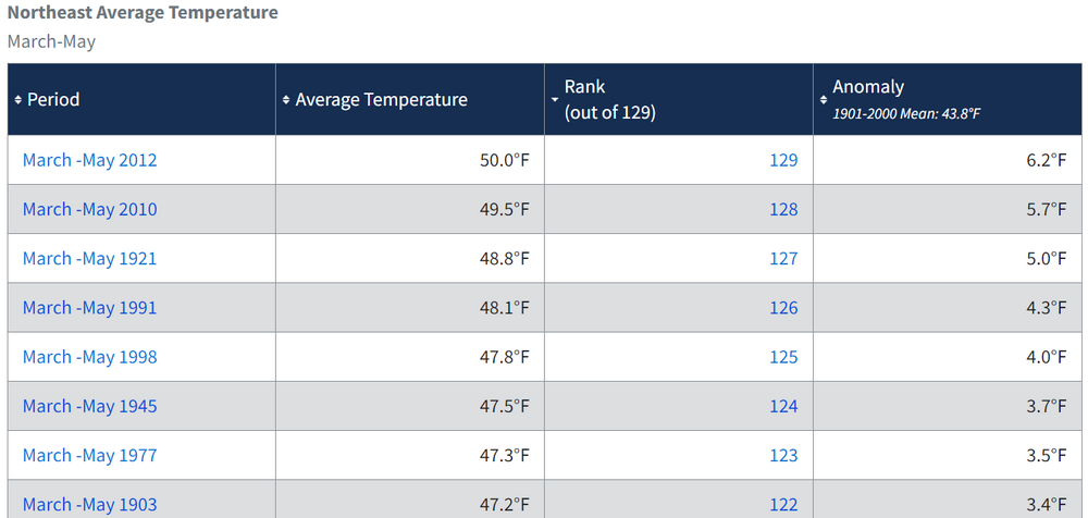
Overall the brutal 1977 winter ended rather abruptly in the NE & quickly transitioned to one of the warmest springs regionally on record. At the time it was the 3rd warmest & even in the face of the recent run of warmth it still remains the 7th warmest on record for the northeast. Pretty amazing that the monster 42" Buffalo snow cover that peaked in early FEB was gone by March 5th.
The May snow event is the ultimate late season fluke event especially for month that is still the 20th warmest May regionally. Boston was 92 degrees only a week after that event.
https://www.ncei.noaa.gov/access/monitoring/climate-at-a-glance/regional/rankings/101/tavg/197705
The core of the historic cold from the fall into the winter 76-77 was situated to our west around Ohio. That was their coldest fall combined with winter period. Also 3 of their top 5 of their coldest winters since the late 1800s occurred in the late 1970s. Most of the Arctic fronts around NYC during those winters were followed by W to NW flow. It’s probably why NYC didn’t get below -10 like they did in 1917-1918 which places in Ohio were able to surpass. The only times that NYC got below -10 were with NW to N flow down the Hudson Valley and an Arctic high over the Great Lakes. These late 70s into 94 Arctic outbreaks were accompanied by highs dropping further SW. The 1917-1918 and Feb 34 Arctic outbreaks had more NW to N flow down the Hudson Valley. Newark and Philly almost got down to -10 in the 1980s when they had more favorable flow that kept the best cold west of the Hudson.
Time Series Summary for Cincinnati Area, OH (ThreadEx)
Click column heading to sort ascending, click again to sort descending.RankEnding DateMean Avg Temperature Sep 1 to Feb 28Missing Count1 1977-02-28 36.1 0 2 1918-02-28 37.8 0 3 1978-02-28 38.9 0 4 1963-02-28 39.7 0 5 1982-02-28 41.1 0 6 1936-02-29 41.2 0 7 1996-02-29 41.3 0 - 1970-02-28 41.3 0 8 1979-02-28 41.5 0 9 1994-02-28 41.6 0 10 1904-02-29 41.7 0 - 1893-02-28 41.7 0
Time Series Summary for Cincinnati Area, OH (ThreadEx)
Click column heading to sort ascending, click again to sort descending.RankSeasonMean Avg TemperatureMissing Count1 1977-1978 21.7 0 2 1976-1977 23.1 0 3 1917-1918 24.4 0 4 1962-1963 25.0 0 5 1978-1979 26.2 0 6 1935-1936 26.3 0 7 1904-1905 27.7 0 8 1981-1982 27.8 0 - 1903-1904 27.8 0 9 1919-1920 28.0 1 10 1969-1970 28.4 0 - 1963-1964 28.4 0 -
1
-
1
-
-
Just now, LibertyBell said:
But if we were around and on here back then we would have hated the 76-77 winter, it was a waste of cold air.
2014-15 was MUCH better.
One of the first indications how cold 76-77 was going to be was NYC getting down to 50° at the end of August. Then the 29° in October. So a tie of the all-time monthly minimum in August and 2nd coldest in October. Then single digits during the first week of December. None of which has been able to be replicated since then.
Time Series Summary for NY CITY CENTRAL PARK, NY - Month of Aug
Click column heading to sort ascending, click again to sort descending.RankYearLowest Min TemperatureMissing Count1 1986 50 0 - 1982 50 0 - 1976 50 0 - 1965 50 0 - 1885 50 0 2 1923 51 0 - 1912 51 0 - 1887 51 0 3 1940 52 0 - 1934 52 0 - 1895 52 0 - 1890 52 0
Time Series Summary for NY CITY CENTRAL PARK, NY - Month of Oct
Click column heading to sort ascending, click again to sort descending.RankYearLowest Min TemperatureMissing Count1 1936 28 0 2 1976 29 0 - 1925 29 0 - 1887 29 0 - 1879 29 0 6 1940 30 0 - 1869 30 0
Time Series Summary for NY CITY CENTRAL PARK, NY
Click column heading to sort ascending, click again to sort descending.RankEnding DateLowest Min Temperature Dec 1 to Dec 7Missing Count1 1875-12-07 8 0 2 1976-12-07 9 0 3 1926-12-07 10 0 - 1882-12-07 10 0 -
2
-
2
-


March 2024
in New York City Metro
Posted
NYC is on track to make it to the top 10 wettest Marches. Some really hot summers followed years with this much March precipitation.
Click column heading to sort ascending, click again to sort descending.