

bluewave
-
Posts
31,713 -
Joined
-
Last visited
Content Type
Profiles
Blogs
Forums
American Weather
Media Demo
Store
Gallery
Posts posted by bluewave
-
-
9 minutes ago, gravitylover said:
Tell us you wouldn't enjoy a snowstorm at the end of May? Of course you would. I'll wishcast that storm right now
")
This blocking pattern going into April looks legit. MJO 8-1 is teaming up with a wave break for Greenland blocking. While the higher elevations are always favored for April snows, this is the type of pattern that could produce a trace that doesn’t accumulate much closer to the coast. I guess it would be like what happened in May 2020. Late season blocks have been becoming more common in recent years.
-
 5
5
-
-
8 minutes ago, lee59 said:
Last month at this time 8% of the country had snow cover, as of yesterday 48% of the country had snow cover.
Approaching the middle of the pack for late March but lower than the record highs were seeing at this time last year.

-
2 hours ago, JetsPens87 said:
It either phases or it acts as a kicker. Really no in between IMO.
I'm not leaning one way or the other yet.
The two streams eventually phase on the EPS by the time it gets east of New England and becomes a potent 50/50 low. A sooner phase like the UK /CMC will just mean heavier rain totals than a later one further east of New England. Either way it looks like more rain for us later in the week. That low creates the wave break and Greenland block then the follow up systems behind are more opportunities for rain into April.


-
4
-
-
It will be interesting to track the evolving storm details for later in the week. It looks like there will be a powerful phase involved. So the timing will be important as to how much heavy rains the region can get. It is also forecast to generate an impressive wave break which could set up a strong Greenland block into early April. That would mean a continued stormy pattern and probably limit the number of 70° days until the blocking relaxes a bit.


-
3
-
 3
3
-
-
That storm later this week should allow several stations to cross the 10” mark for the month.
Data for March 1, 2024 through March 24, 2024
Click column heading to sort ascending, click again to sort descending.StateNameStation TypeTotal PrecipitationNY ST. JAMES COOP 9.93 CT GUILFORD COOP 9.63 NY CENTERPORT COOP 9.29 CT IGOR I SIKORSKY MEMORIAL AIRPORT WBAN 9.14 CT NORWICH PUBLIC UTILITY PLANT COOP 9.09 NY MOUNT SINAI COOP 9.03 NJ HARRISON COOP 8.82 NY JFK INTERNATIONAL AIRPORT WBAN 8.79 NY LAGUARDIA AIRPORT WBAN 8.78 NJ TETERBORO AIRPORT COOP 8.41 NJ TETERBORO AIRPORT WBAN 8.41 CT MERIDEN MARKHAM MUNICIPAL AP WBAN 8.40 CT NEW HAVEN TWEED AP WBAN 8.31 NY UPTON COOP - NWSFO NEW YORK COOP 8.31 NY NY CITY CENTRAL PARK WBAN 8.24 -
1
-
-
1 hour ago, chubbs said:
Yes we are still breaking daily re-analysis records, but not by "gobsmacking" amounts like we were in the second half of last year. Anomalies are running closer to where you would expect them to be, above last year and moderately above 2016, the last strong nino. We have been in a rough anomaly plateau since last September. With la nina developing, and normal seasonal effects, would expect anomalies to begin to drop soon, similar to 2016, and to cool below 2023 later in the year. We'll see.
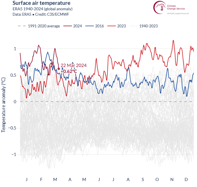
Yeah, the second half of 2023 was so much more extreme than anything we have seen before.
-
1
-
 1
1
-
-
25 minutes ago, SnoSki14 said:
Despite record warmth this month we're still getting late freezes.
29F this morning
If we had another week of the 65-75+ warmth and then got hit with these freezes we would have seen a lot of bloom damage.
It figures the MJO would wait until March to finally go into phase 8 like last year.
Time Series Summary for NY CITY CENTRAL PARK, NY
Click column heading to sort ascending, click again to sort descending.Ending DateLowest Min Temperature Mar 19 to Mar 31Missing Count2024-03-31 29 8 2023-03-31 29 0 

-
2
-
-
Record air and sea surface temperatures continue.
-
3 hours ago, Roger Smith said:
3.66" at NYC, ranks third highest daily rainfall in March.
Yeah, a top 3 finish with JFK recording it’s wettest March.
Maximum 1-Day Total Precipitation
for NY CITY CENTRAL PARK, NY
Click column heading to sort ascending, click again to sort descending.RankValueEnding DatePeriod of record: 1869-01-01 to 2024-03-23 1 4.25 1876-03-25 2 3.86 2010-03-13 3 3.66 2024-03-23 4 3.44 1977-03-22 5 3.10 1983-03-18 6 2.98 2005-03-28 7 2.95 1914-03-01 8 2.94 1901-03-11 9 2.63 1979-03-06 10 2.61 1953-03-13
Time Series Summary for JFK INTERNATIONAL AIRPORT, NY - Month of Mar
Click column heading to sort ascending, click again to sort descending.RankYearTotal PrecipitationMissing Count1 2024 8.79 8 2 2010 8.62 0 3 1980 8.17 0 4 1953 7.93 0 5 2001 7.00 0 6 1993 6.83 0 7 1983 6.66 0 8 1984 5.99 0 9 2017 5.79 0 -
 2
2
-
-
This band coming through has some of my heaviest rainfall rates of the year so far just east of KHVN.

-
2
-
-
18 minutes ago, SnoSki14 said:
A harbinger of what's to come this summer & early fall?
Pretty ridiculous SST warmth in the Atlantic for so early in the year combined with a developing La Niña.
-
2
-
-
33 minutes ago, LibertyBell said:
this is absolutely crazy Don, how can this happen in March, with no tropical air around?
The radar presentation reminds me of when a tropical system makes landfall to our south and runs up just inland from the coast.
-
3
-
-
Wettest March day on record for Philly.
-
2
-
-
-
17 minutes ago, jm1220 said:
March even into April is some of their prime season in NNE/Adirondacks ski country.
Yeah, nice event for the ski resorts.
-
2
-
-
5 minutes ago, IrishRob17 said:
Up to 33.5 degrees with 1.12”, ice slowly melting here.
40 and rain here.
-
2 hours ago, snowman19 said:
My wife’s cousin lives in Pine Bush, she said there’s real good icing up that way
2 hours ago, IrishRob17 said:I believe it, I’m just a bit south of there. Based on the traffic maps the roads are ok but I’m sure there some sights to be seen if I have the ice at 400’
-
5
-
-
Looks like a top 10 wettest March day potential.
Maximum 1-Day Total Precipitation
for NY CITY CENTRAL PARK, NY
Click column heading to sort ascending, click again to sort descending.RankValueEnding DatePeriod of record: 1869-01-01 to 2024-03-22 1 4.25 1876-03-25 2 3.86 2010-03-13 3 3.44 1977-03-22 4 3.10 1983-03-18 5 2.98 2005-03-28 6 2.95 1914-03-01 7 2.94 1901-03-11 8 2.63 1979-03-06 9 2.61 1953-03-13 10 2.45 2010-03-30
Maximum 1-Day Total Precipitation
for NEWARK LIBERTY INTL AP, NJ
Click column heading to sort ascending, click again to sort descending.RankValueEnding DatePeriod of record: 1931-02-01 to 2024-03-22 1 3.99 2010-03-13 2 2.71 1993-03-13 3 2.60 1977-03-22 4 2.57 1991-03-03 5 2.53 1953-03-13 6 2.50 1934-03-31 7 2.44 1983-03-18 8 2.39 1997-03-31 9 2.35 1962-03-12 10 2.34 1951-03-30 -
1
-
-
1 hour ago, jm1220 said:
Last year or the year before GA had a very damaging freeze for the peach crop after a freeze hit right after our new normal much warmer than average “winter” started the growing season early. Maybe this will be a more frequent occurrence in this new climate normal with the growing season starting earlier and earlier but still prone to cold snaps.
The worst hard freeze that I ever had in my garden back on the LI South Shore was in November 2017. We had just come off the warmest October on record with numerous days in the 70s and 80s. The 70s persisted into the first week of November. This allowed my garden to have one of my latest fall blooms. All the impatiens were really blooming strong like it was still mid-summer into November. My Encore Azaleas had a unusually good fall bloom also. So when we had 3 consecutive near record lows in the mid 20s around November 10th all the Impatiens and the Azalea blooms quickly shriveled up. The Azalea never came back the next spring so I had to replace it with some beautiful fountain grass which was much lower maintenance. That fall was a preview of the following winter into spring with the period of Arctic cold after Christmas coexisting with the historic February 80° warmth. So a continuation of the short Arctic outbreak pattern surrounded by much more impressive and longer lasting warmth.
-
2
-
-
1 hour ago, dWave said:
Yeah, I got down to 28. Trees etc in bloom look unscaved. Many of the cherry blossoms were past peak anyway, and the later blooming varieties haven't opened yet.
The really damaging freeze around the region was last May when some spots in Upstate NY got down into the low 20s.
https://www.wamc.org/2023-09-19/a-late-may-frost-caused-some-ny-farms-to-lose-most-of-their-apples
The evening of May 17 Critz turned on a large frost fan which helps mix warmer air from above with cooler air at ground level to try and prevent frost forming on the flowering trees. Then the temperature dipped down to 23 degrees.
"32 is okay," Critz said. "30, 29, you start having a little damage maybe 10 percent. You can go down to like 27 you'd be like 50% damage, but usually there's enough blossoms even if you lose 50% of them, you're still going to bear a good crop. Then it went down to 23 and just killed everything."
The apples he does have, have a frost ring around them. These apples will be pressed to make sweet cider and hard cider.
-
Looks like NYC only got down to 29°so it avoided the hard freeze some of the colder guidance was calling for. The GFS actually did better again that some of the other guidance which had mid 20s. So hopefully there won’t be much damage to the early blooms.
-
A real soaker on the HREF with a 2.5” to locally 5.0” range where the best banding and training sets up.


-
3
-
-
43 minutes ago, Brian5671 said:
the odd thing is I hear from people lately who have never had water and now they do-shows how high the water table got this winter....
October 2005 was the beginning of the shift to people having basement flooding when they never did before. Especially when I was living back in Long Beach. Numerous months since then with near or over 10” of rain at spots in the area.
-
1 hour ago, snowman19 said:
3-4 inch rain totals when all is said and done would not surprise me. It's going to be absolutely torrential in the metro area on Saturday
This could push parts of the area close to 10.00” on the month.
Data for March 1, 2024 through March 21, 2024
Click column heading to sort ascending, click again to sort descending.StateNameStation TypeTotal PrecipitationNY SMITHTOWN 2.0 SSW CoCoRaHS 7.64 CT SALEM 3.6 SE CoCoRaHS 7.50 NY DEER PARK 1.0 NE CoCoRaHS 7.18 CT OAKDALE 2.6 WNW CoCoRaHS 6.97 CT EAST LYME 0.5 SW CoCoRaHS 6.97 CT NORWICH 5.2 SE CoCoRaHS 6.97 CT MYSTIC 3.4 NW CoCoRaHS 6.96 CT NORWICH 2.5 NNE CoCoRaHS 6.89 CT STRATFORD 0.2 ESE CoCoRaHS 6.81 NY ST. JAMES COOP 6.80 NY HOWARD BEACH 0.4 NNW CoCoRaHS 6.68 CT PROSPECT 1.9 ENE CoCoRaHS 6.63 CT FAIRFIELD 1.5 NE CoCoRaHS 6.56 CT STRATFORD 0.9 W CoCoRaHS 6.53 CT GUILFORD COOP 6.44 CT GUILFORD CENTER 2.7 WSW CoCoRaHS 6.44 CT ESSEX VILLAGE 0.9 S CoCoRaHS 6.44 NY CENTEREACH 1.3 NE CoCoRaHS 6.37 NY MOUNT SINAI COOP 6.36 CT NORWICH PUBLIC UTILITY PLANT COOP 6.35 NY SELDEN 1.6 ESE CoCoRaHS 6.32 NJ MONTCLAIR 0.7 N CoCoRaHS 6.26 NY WANTAGH 0.3 ESE CoCoRaHS 6.23


March 2024
in New York City Metro
Posted