

daxx
-
Posts
1,401 -
Joined
-
Last visited
Content Type
Profiles
Blogs
Forums
American Weather
Media Demo
Store
Gallery
Posts posted by daxx
-
-
14 minutes ago, bubbler86 said:
Saw a post about the GFS moving east by 300 miles ...I missed that one. It was on the Western side of MI at 0Z and now the Eastern side so some East but maybe 100-125 miles. It was in a similar place at 18Z. Probably the worst look. That UK snow map seems like fantasy to me as we have seen the UK cross over to the less snowy solutions in the last 36 hours over and over...UK's depiction is more something you would see with a low coming from Alabama moving East/North East vs. a western cutter. My biggest worry is the EPS and Euro keep moving the snow farther and farther north. They still show 4-8" here but the no snow line is not far from the Mason Dixon. I think that is less of an issue with temps and more an issue of the orientation of qpf and less falling here. Still think we get a plowable followed by a period of rain and temps 35-40.
Edit-All these snow maps include the 2-3" most forecast for Sunday night so the Tuesday event is really a 3-6" type deal vs. 4-8 like I mentioned above.
It sure would be nice if those snow maps didn't exist. Most people would be more realistic of the amount ofsnow that was truly going fall.
-
For this next system I would expect cad winning out. This far out I would not pay attention too much at 2m temps. That high too our north should keep us east of the mountains stuck in the cold air for awhile. To me this is a snow to ice classic around here. Should things hold the way they are now come Sunday models should start showing 2m temps staying at or below freezing east of the mountains more than they show right now. Then again things could go the other way as well weaker high , storm track ....
-
29 minutes ago, WesterlyWx said:
My favorite webcam off the tug in Worth,NY. They always seem to be in the perfect spot and always get pounded. Looks awesome there right now!

Yes I've been to Worth many times. If I ever move to the Tug Hill it would be there. If you ask me it is the best location on the tug.
-
 3
3
-
-
2 minutes ago, Atomixwx said:
Your mom nudges south.
What are we drinking? Anderson's buying, apparently.
Yea not pretty. I'm sure 2001 will have the highest total in our forum.
-
I'm out for a little good luck down there.
-
Cold as balls Monday morning.
-
Just now, canderson said:
Euro almost looks like more plain rain than zr to me, am I misinterpreting?
(fwiw I'll be ok with this, ice is no bueno)
No your right
-
Its definitely not the runs of old!
-
I woud not say a full cave. For us down here toast. Central nice snow event bfore junk.
-
Euro snow to mix then rain for southern counties. Central counties nice thump then mix. Northern tier snow.
-
23 minutes ago, Itstrainingtime said:
Hot off the press (with track of LP included)
He was saying Monday it would cross Lancaster county.
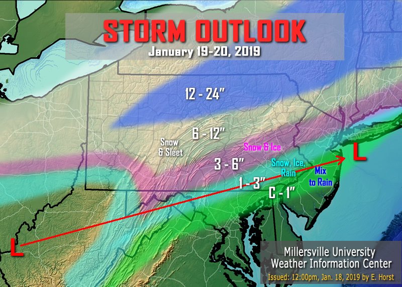
Nice I'm in the 12-24. At least until I come back home.
-
3 minutes ago, Itstrainingtime said:
Don't worry...Horst is calling for another rain storm by midweek!
Yea mid week will most likely be a rain event. After that I have high hopes! Lol
-
Fv3 looks like sh!t as well. Oh well I think we are headed in the right direction for more snow beginning later next week.
-
I thought the gfs looked terrible. Not good for a lot of people except the far north.
-
It looks like the fv3 came in better with front end thump for Saturday.
-
1
-
-
Just now, CarlislePaWx said:
I just looked and actually that panel at 09Z is the coldest it gets. 12Z comes back up a few degrees.
If your going by 3 hour panels yes your right.
-
Just now, bubbler86 said:
TT does not have all the panels yet but this should suffice for shock.

It gets even colder after that panel
-
Just now, bubbler86 said:
Extreme Surface Temps Monday Morning (Icon)

If you can show Tuesday morning. Kind of crazy.
-
Just now, bubbler86 said:
The Icon is still going to be our Icon at 18Z. Snow maps should be fun to look at.
Yea it just will not fold.
-
1 minute ago, pasnownut said:
Saw ctp graphic. Wow.
What part of the daks u in? Used to snowmobile tug. Bud had a place in brantingham?
I'm in Old forge. Stayed on the Tug many times. Snowmobiling on weekends are crazy here, weekdays are great.
-
Just now, canderson said:
That's a sleetstorm then a snowstorm then isn't it?
546 thickness and 850 are very close together so yea I think there would be sleet thrown in. Above there snow looks to be a lock.
-
I'm sure mag and them guys up there will settle for that run. They will have a glacier. Lol
-
Northwest of Harrisburg does not go above freezing at surface for the entire event. The highest I see for State college is 28 at the surface.
-
No miracle on the Euro. Snow to ice then rain for lsv. More as you go north and west. Head to the cabin Nut they get slammed up that way.

Central PA - Jan/Feb 2019 Obs and Discussion
in Upstate New York/Pennsylvania
Posted
Don't get me wrong they are fun to look at but to use them seriously that is something I won't do. If they were accurate I would be buried alive by now.