frd
-
Posts
6,934 -
Joined
-
Last visited
Content Type
Profiles
Blogs
Forums
American Weather
Media Demo
Store
Gallery
Everything posted by frd
-
Right at the cusp. .
-
Progressing nicely .
-
Yeah , looks good, but when, if ever, has the control made a trend change and the op and ensembles followed? Regardless, still have a ways to go on this one.
-
Wasn't it two years ago that a pv filament or extension suppressed a snowstorm to Virginia and North Carolina. We were originally thinking a foot around here. And that was pretty much it for the winter. A real bummer.
-
@psuhoffman What apparent weather would this look deliver? Bowling bowl blizzard ? WTF

-
Exactly, very impressive to see the movement stop and head the other way. You have to think there might be some interesting changes in store for the medium range given the block.
-
Expect some bizarre solutions in the weeks ahead. Of course the models will be able to handle the physics. Nothing personal GFS.
-
It does, for one thing I share the same mean as psu ! To me that is a positive. And as I mentioned, the best potential may be after the 17 th , if so, we are not in range yet. Again, fun to look at, but only relevant when numbers go way up. meaning higher probability of a more significant event.
-
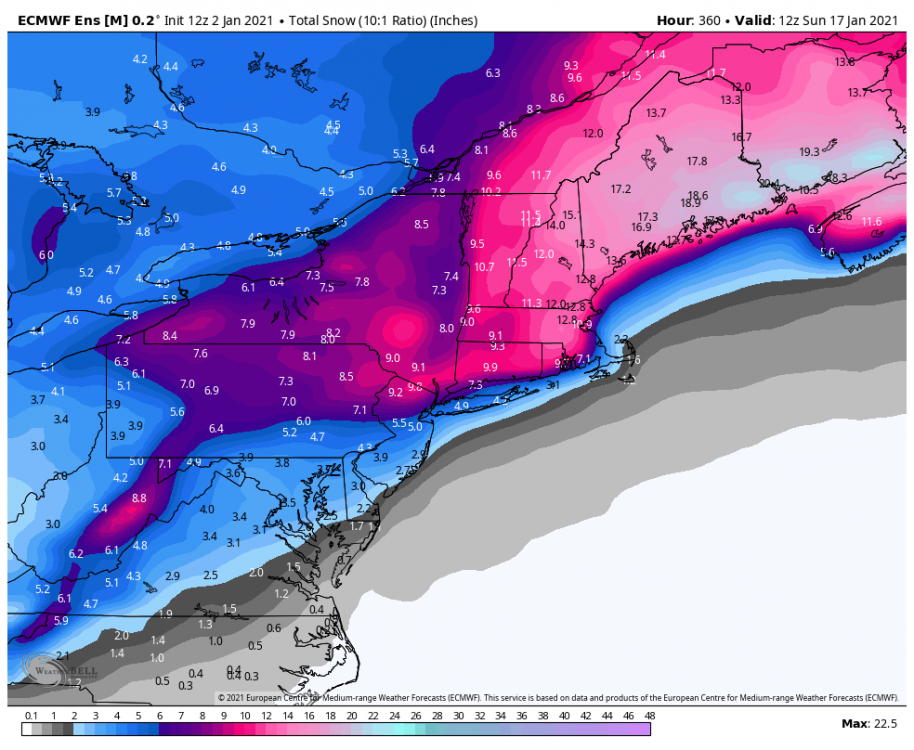
This only goes to Jan. 17th. It's not awesome, but will use it for trends.
-
@psuhoffman Interesting..... @griteater Replying to @MattHugo81 Have you seen these tropical forcing charts referenced by @antmasiello the other day? Moves into Phase 7-8-1-2 type forcing from mid-Jan on 12:18 PM · Jan 2, 2021·Twitter Web App
-
That is typical and makes sense based on the history of prior events. Wondering once we pass Jan 5 th does modeling become a little clearer. Also, this recent post by HM is interesting. @antmasiello Replying to @antmasiello @griteater and @MattHugo81 So what this means is an increasing western hemisphere like response mid month becoming IO late month. That should propagate back to Maritimes for February. 12:31 PM · Jan 2, 2021
-
Do you think the window extends to Fed 1 st ? I vaguely recall you mentioning suppression risks rise after the 20 th.
-
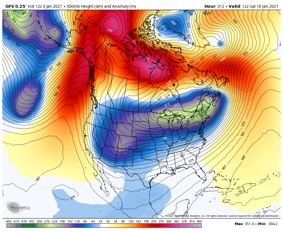
1043 mb High pressure where you usually see a low the past few winters .
-
Well now. Of course the GFS is the first issue, and then hour 288 is the second, but very interesting.
-
For inquiring minds, this is a new outcome out in fantasy land, a split versus a displacement. Or a displacement followed up by a split.
-
Seems everything has moved up a bit, also as you stated yesterday , I forget the exact specifics , colder versus warmer outcomes the last few days in the modeling may be the trend.
-
@CAPE Sipping my coffee and enjoying my new monitor which shows these forecasts. What is your latest feelings ? Seems the GEFS looks very nice ! And appears to get colder in time . This is the window which some favor for a SECS Day 6 to 16 .
-
Can anyone post the over night AO ensemble run from the Euro. Would like to compare it against the CPC data. It appears that forecast drops the AO to - 4 SD near the 7 th of Jan. and after that the forecast members wash out, generally rising, but with no clear consensus.
-
Even for the lowlands, like us? Ah I see it now, thanks.
-
This site creates analog packages from the CPC data https://www.daculaweather.com/4_cpc_8-14_analog.php Some examples below.
-
Yep, too warm and too late. But, the general message could be as the long range turns to medium range the trend to colder wins out. Also, this may block could manifest itself with areas North of us cashing in first and then a general movement South mid month with a more Mid Atlantic type flavor finally going to a suppressed deep South hit. EPS shows several opportunities near mid month, with active tracking near or after the 8 th.
-
Maybe some indications the intense plunge in the AO can set-up a discharge of arctic air moving SSE across Eastern Canada by mid month and beyond.
-
I actually agree, totals seem near climo, and does not match the potential of the pattern. Then again, who really knows, and besides the best potential may be after this time period. Anyone seriously considering this as the most likely outcome needs to reassess. However, if the mean hits 5 or more inches then it has real statistical importance and I would get more hopeful of seeing a significant snow event.
-
Not as much of an issue up North, but from say Wilmington, DE. and points South and Southwest we really do need some colder air poised in our source regions. The cold nearby is marginal at best. As psu stated, it adds another element to consider ( and may I add worry about ) when the 500 pattern screams snowstorm, but in reality it is only rain or snow to rain.