

WxUSAF
-
Posts
24,675 -
Joined
-
Last visited
Content Type
Profiles
Blogs
Forums
American Weather
Media Demo
Store
Gallery
Posts posted by WxUSAF
-
-
Fringed as f-ck
-
 1
1
-
-
Storms firing along the outflow boundary in HoCo and MoCo. Hope I get some rain...
-
HR^3 has a MCS remnant coming through in the predawn time period.
-
Woo sprinkles.
-
Just heard thunder, but looks like the storm will stay to the NW of me while also efficiently robbing the area of CAPE so the next line skips over me.
-
Woo for scattered gusty showers!!!
-
Been repainting my deck for the last five week. Finally have one full coat on it. Previous owners did a sh-tty job when they did it so the deck was peeling and two colors. Looks much better now.
And as always trying to get grass to grow in bare spots. This weekends 0.03” of rain didn’t help much.
-
My hands have been very dry.
-
13 hours ago, gymengineer said:
Wait, how did it accumulate on streets here and not where you are?
See the photos from Wheaton and Savage:
I'm pretty sure Matt has posted pics of snow on paved surfaces in DC that early morning too.
Maybe it did and I just forgot. But I remember having no issues driving to work.
-
2 minutes ago, gymengineer said:
And I will still enjoy that 3" slop storm.
") I have very pleasant memories of 3/24-25/13.
I have very pleasant memories of 3/24-25/13.
My jumping date is 4/7 in any winter-- the end date of the last ground covering snow in my lifetime. (1990- 3.8" at IAD)
I thought 3/25/13 was ridiculous. I had ~6", nothing on the streets, didn't even get a day off work, and it was all gone by lunch.
-
 1
1
-
-
My WAG is IAD and BWI at least get a fraction of an inch in February and then all 3 airports get 3" of slop overnight in mid-March that melts by 10am. It's like 12-13 but even worse.
-
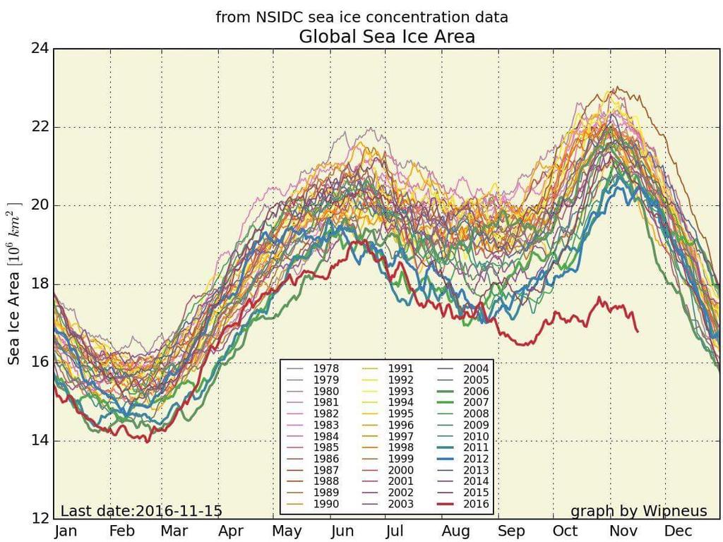
I think that's the idea, yes. So low southern ice and the ridiculously low Arctic ice gives you that insane figure.
-
Ooof. Holy shi-t.

-
Saw on Twitter that the IAD sounding had 1.8" of precipitable water, which sets the all-time Dec-Apr record.
-
What's the most anomalous single day departure on record for the airports? We're looking at a +30 or so for xmas eve?
-
New paper linking the cold winter of 13-14 with the warm central Pacific SST anomaly.
http://onlinelibrary.wiley.com/wol1/doi/10.1002/2015GL063083/full
-
10 below normal months at BWI in the period of November 13-February 15.
February 15, January 15, November 14, August 14, July 14, April 14, March 14, February 14, January 14, November 13
That's a pretty impressive run given climate and UHI both progressively working against below normal temps. Maybe some of the stat-minded folks can tell us how exceptional it is?
-
JB is so hilariously ignorant
Amazing how Mars has climate change with atmosphere about the same %co2 as Venus,but much less dense. Isnt that special?
-
1st time with 4 consecutive BN months at BWI since 1970 apparently? According to Tony Pann.
-
3 degrees at BWI now so the record low part has been broken... just need to stay below 22 for the high now, which I think we'll do.
That's a gimmee today. Same for IAD.
-
Record high warning being issued for Sunday at BWI.
Wow…62F is the record. Lowest record high max of the entire month and only set 2 years ago! That's a gimmee. IAD's record is 61F, also set in 2011. Both of those are probably locks. DCA is 68F. That's going to be close.
-
Here's a nice reference for the upper air pattern when a KU is about to happen:
-
^that was the greatest quake meme ever
-
Speaking of CAPE and following up about the skew-T discussion, the amount of CAPE can be directly calculated from the skew-T by adding up the area between the parcel trajectory (along a moist adiabat) and the environmental temperature profile. So, if there's a lot of room between the two, you can know the CAPE is high before looking at the calculated parameters directly.
The "opposite" of CAPE is CIN (convective inhibition) and is also measured in J/kg. CIN occurs when the parcel trajectory will lead it to be colder than the environmental temperature. If the parcel is colder, it's not buoyant in the free atmosphere and needs to be forced to a height in the atmosphere where it is bouyant before it can freely begin to rise. When people speak of a "cap", there means the atmospheric profile has a certain amount of CIN to overcome.

2018 Mid-Atlantic General Severe Discussion
in Mid Atlantic
Posted
0.02”