John1122
-
Posts
11,996 -
Joined
-
Last visited
Content Type
Profiles
Blogs
Forums
American Weather
Media Demo
Store
Gallery
Everything posted by John1122
-
My friend from Mt Juliet got hit, but fortunately she's physically okay. She's not been able to contact all of her employees yet to check on them though.
-
Looks like Powell is in this one. BULLETIN - EAS ACTIVATION REQUESTED Tornado Warning National Weather Service Morristown TN 435 AM EST Tue Mar 3 2020 The National Weather Service in Morristown has issued a * Tornado Warning for... Northeastern Knox County in east Tennessee... * Until 500 AM EST. * At 435 AM EST, a severe thunderstorm capable of producing a tornado was located near Knoxville, moving east at 60 mph. HAZARD...Tornado and quarter size hail. SOURCE...Radar indicated rotation. IMPACT...Flying debris will be dangerous to those caught without shelter. Mobile homes will be damaged or destroyed. Damage to roofs, windows, and vehicles will occur. Tree damage is likely. * This tornadic thunderstorm will remain over mainly rural areas of northeastern Knox County, including the following locations... Maloneyville, House Mountain State Park, Mascot, Powell, Halls and Kimberlin Heights. This includes the following highways... Interstate 40 in Tennessee between mile markers 388 and 405. Interstate 75 in Tennessee between mile markers 108 and 117. PRECAUTIONARY/PREPAREDNESS ACTIONS... TAKE COVER NOW! Move to a basement or an interior room on the lowest floor of a sturdy building. Avoid windows. If you are outdoors, in a mobile home, or in a vehicle, move to the closest substantial shelter and protect yourself from flying debris. Tornadoes are extremely difficult to see and confirm at night. Do not wait to see or hear the tornado. TAKE COVER NOW!
-
Heading straight for Holston's backyard now.
-
BULLETIN - EAS ACTIVATION REQUESTED Tornado Warning National Weather Service Morristown TN 335 AM EST Tue Mar 3 2020 The National Weather Service in Morristown has issued a * Tornado Warning for... Morgan County in east Tennessee... * Until 400 AM EST. * At 335 AM EST, a severe thunderstorm capable of producing a tornado was located 10 miles north of Fairfield Glade, or 16 miles northeast of Crossville, moving east at 50 mph. HAZARD...Tornado and half dollar size hail. SOURCE...Radar indicated rotation. IMPACT...Flying debris will be dangerous to those caught without shelter. Mobile homes will be damaged or destroyed. Damage to roofs, windows, and vehicles will occur. Tree damage is likely. * This dangerous storm will be near... Wartburg around 355 AM EST. Other locations impacted by this tornadic thunderstorm include High Point, Coalfield, Frozen Head State Park, Deerlodge, Petros and Sunbright. PRECAUTIONARY/PREPAREDNESS ACTIONS... TAKE COVER NOW! Move to a basement or an interior room on the lowest floor of a sturdy building. Avoid windows. If you are outdoors, in a mobile home, or in a vehicle, move to the closest substantial shelter and protect yourself from flying debris. Tornadoes are extremely difficult to see and confirm at night. Do not wait to see or hear the tornado. TAKE COVER NOW! && LAT...LON 3624 8489 3623 8457 3623 8455 3620 8447 3616 8444 3614 8445 3611 8442 3610 8438 3602 8438 3601 8440 3604 8478 3609 8480 3609 8483 3614 8487 3616 8491 3621 8491 TIME...MOT...LOC 0835Z 271DEG 42KT 3615 8488 TORNADO...RADAR INDICATED HAIL...1.25IN
-
Hopefully this missed Shocker.
-
The National Weather Service in Nashville has issued a * Tornado Warning for... Southeastern Overton County in Middle Tennessee... Northern Cumberland County in Middle Tennessee... East central Putnam County in Middle Tennessee... Southwestern Fentress County in Middle Tennessee... * Until 245 AM CST. * At 212 AM CST, a severe thunderstorm capable of producing a tornado was located near Monterey, or 11 miles east of Cookeville, moving east at 60 mph. HAZARD...Tornado and quarter size hail. SOURCE...Radar indicated rotation. IMPACT...Flying debris will be dangerous to those caught without shelter. Mobile homes will be damaged or destroyed. Damage to roofs, windows, and vehicles will occur. Tree damage is likely. * This tornadic thunderstorm will remain over mainly rural areas of southeastern Overton, northern Cumberland, east central Putnam and southwestern Fentress Counties, including the following locations... Clarkrange. This includes Interstate 40 between mile markers 296 and 308. PRECAUTIONARY/PREPAREDNESS ACTIONS... TAKE COVER NOW! Move to a basement or an interior room on the lowest floor of a sturdy building. Avoid windows. If you are outdoors, in a mobile home, or in a vehicle, move to the closest substantial shelter and protect yourself from flying debris. Tornadoes are extremely difficult to see and confirm at night. Do not wait to see or hear the tornado. TAKE COVER NOW! &&
-
Friend of mine in that area just posted that the sirens were going off. Hope all our mid Valley folks are okay.
-

TN valley heavy rain/flooding week of whenever
John1122 replied to janetjanet998's topic in Tennessee Valley
Another 4 inch week of rain would probably out us back into areal flooding. The ground is like a full sponge right now. I had a flat earlier and had the worst time changing it. Due to the nature of where I live there are sections of paved road and sections of gravel. My flat happened in gravel. It was like soup, my jack kept sinking into the ground. Soil is soaked at every level. -
TN valley heavy rain/flooding week of whenever
John1122 replied to janetjanet998's topic in Tennessee Valley
Had an 8 foot deep mega pothole/sinkhole open in an area roadway this week. There was a huge one in a backyard a couple weeks ago. -
TN valley heavy rain/flooding week of whenever
John1122 replied to janetjanet998's topic in Tennessee Valley
.91 in the bucket since around 3am this morning. MRX has most of the area in the 4-6 inch range by Thursday. Not sure that flash flooding will be an issue but a lot of slow rising water issues will happen at that point. I'm now at 8.17 inches of rain already for the month and had 7.35 last month. So already 8 inches or so above normal for 2020. -
TN valley heavy rain/flooding week of whenever
John1122 replied to janetjanet998's topic in Tennessee Valley
Not a pretty picture on the 18z GFS Mon-Thurs morning. -
TN valley heavy rain/flooding week of whenever
John1122 replied to janetjanet998's topic in Tennessee Valley
WPC day 3 outlook. -
TN valley heavy rain/flooding week of whenever
John1122 replied to janetjanet998's topic in Tennessee Valley
Hwy 25w is closed here. 5.14 inches of rain from the event so far. Still raining. -
TN valley heavy rain/flooding week of whenever
John1122 replied to janetjanet998's topic in Tennessee Valley
It is absolutely dumping down in buckets out there now with fairly frequent thunder in the area. -
TN valley heavy rain/flooding week of whenever
John1122 replied to janetjanet998's topic in Tennessee Valley
Just heard thunder rumble. Snow countdown clock is on. -
TN valley heavy rain/flooding week of whenever
John1122 replied to janetjanet998's topic in Tennessee Valley
Extremely heavy rain currently falling. My power just came back on after going out around 4pm. Crossed the 3 inch mark as of 6:15. -
TN valley heavy rain/flooding week of whenever
John1122 replied to janetjanet998's topic in Tennessee Valley
Currently at 2.08 inches since Monday evening. Creeks are high and rising and it's pouring down now with a tongue of 3-4 more inches expected through tomorrow. All this coming off the rainiest year ever here, which followed the prior rainiest year ever with the GFS forecasting 12-16 inches of rain for the area over the next 2 weeks. I've had 162 inches of rain in the past 25 months. That's an average of 6.5 inches of rain per month for over 2 consecutive years. That came on the heels of one of the worst droughts we've seen here. The weather is nothing but extremes these days. Extreme warmth, extreme drought, extreme rains, and on the rare times it's managed to get wintry and cold, it was extreme those winters too. -
From what I've seen it's been verifying similarly since November or December. It is much warmer than the North American models because they've been ridiculous. the off the chart GEFS had been verifying almost 8 degrees too cold.
-
Current 90 day model bias. Hopefully these update in the page but maybe not. Won't bother with the Canadian, because they upgraded recently, but the old Canadian was in the 4-5+ degrees top cold at every period from 2-5 through 11-15. The most accurate 2-5 day temp forecast was NWS forecast offices, almost mirrored by GFS MOS. For longer range the Euro Op was best, but the GFS OP is surprisingly better than the Ensembles. The Canadian stunk at every level. Euro Ens GFSENS Euro Op GFS OP
-
That area is strangely susceptible to tornadoes. They had one on Halloween night. There's been one tornado in my county since 1935 and it was on the ground here for about 1 mile before crossing into Claiborne Co, but Claiborne gets a ton of tornadoes by comparison.
-
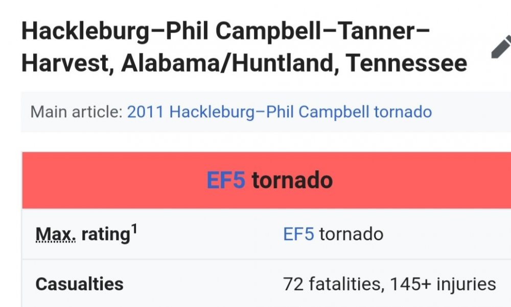
Yep. The tornado history site counted them as Tennessee F5. I believe 3 of the F4 also started outside of Tennessee on there so not sure if they were F4 in the state or not. The other 29 F4 formed in Tennessee.
-
I believe the tornado history site mistakenly counted this one and one from the April 1974 outbreak that crossed from Northern Alabama into Tennessee.
-
There have been 92 F3, 32 F4 and 3 F5 in Tennessee.
-
TN valley heavy rain/flooding week of whenever
John1122 replied to janetjanet998's topic in Tennessee Valley
2.38 inches and pouring down out there right now with some heavy upstream returns coming. Some flooding issues cropping up in the area and creeks are very high. -
TN valley heavy rain/flooding week of whenever
John1122 replied to janetjanet998's topic in Tennessee Valley
Now at 1.28 after moderate/heavy rain for the past few hours.