Tyler Penland
-
Posts
2,523 -
Joined
-
Last visited
Content Type
Profiles
Blogs
Forums
American Weather
Media Demo
Store
Gallery
Everything posted by Tyler Penland
-

2022-2023 Fall/Winter Mountains Thread
Tyler Penland replied to BlueRidgeFolklore's topic in Southeastern States
Finally all snow with this band. Looks like my high for the day will be 38.1. Temp crashing now. -
2022-2023 Fall/Winter Mountains Thread
Tyler Penland replied to BlueRidgeFolklore's topic in Southeastern States
Little lightning in NE TN. Sent from my Pixel 5 using Tapatalk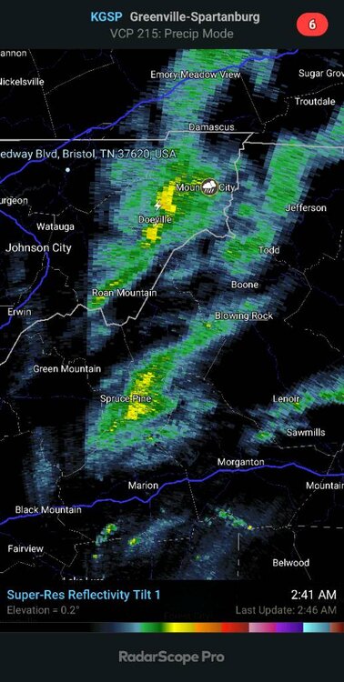
-
2022-2023 Fall/Winter Mountains Thread
Tyler Penland replied to BlueRidgeFolklore's topic in Southeastern States
Temp still creeping up. 37.4 with light rain now. Sent from my Pixel 5 using Tapatalk -
2022-2023 Fall/Winter Mountains Thread
Tyler Penland replied to BlueRidgeFolklore's topic in Southeastern States
Teensy flakes fluttering here. Temp bumped up to 35.1 Temp still rising slowly. Can hear the wind up above roaring. Sent from my Pixel 5 using Tapatalk -
2022-2023 Fall/Winter Mountains Thread
Tyler Penland replied to BlueRidgeFolklore's topic in Southeastern States
Where you at? Pretty calm over here in Foscoe. I live more or less in a hole though just a quarter mile off the Watauga River so we are decently protected from wind. Sent from my Pixel 5 using Tapatalk -
2022-2023 Fall/Winter Mountains Thread
Tyler Penland replied to BlueRidgeFolklore's topic in Southeastern States
Temp falling pretty quick down to 34.5 no precip yet. Won't be wasting much on liquid it doesn't appear. This assumes the upper temps catch up. Mesoanalysis has 850s back west of Morristown still. -
2022-2023 Fall/Winter Mountains Thread
Tyler Penland replied to BlueRidgeFolklore's topic in Southeastern States
Worth noting looking back towards Paris, TN the HRRR has been nearly spot on with the temperature drop. NAM is running a little warm and the GFS and Euro even more so. Sent from my Pixel 5 using Tapatalk -
2022-2023 Fall/Winter Mountains Thread
Tyler Penland replied to BlueRidgeFolklore's topic in Southeastern States
Also don't know if this got mentioned but Beech is closed the next 2 days. Last year it was too warm for Christmas, this year the opposite. Sent from my Pixel 5 using Tapatalk -
2022-2023 Fall/Winter Mountains Thread
Tyler Penland replied to BlueRidgeFolklore's topic in Southeastern States
I'm fascinated that there isn't even a WWA up here. Widespread black ice at the very least seems pretty likely if not guaranteed. That plus several inches of snow along the border you'd think would prompt one. Sent from my Pixel 5 using Tapatalk -
2022-2023 Fall/Winter Mountains Thread
Tyler Penland replied to BlueRidgeFolklore's topic in Southeastern States
This will be my first time seeing sub zero. I'm a bit excited about that, although I'm sure that will wear off quick. Lol Sent from my Pixel 5 using Tapatalk -
2022-2023 Fall/Winter Mountains Thread
Tyler Penland replied to BlueRidgeFolklore's topic in Southeastern States
37.8 and creeping downward here south of Boone. Weirdly calm out there. They hadn't touched the roads when I came home about 730. I think some secondaries had been done but none of the main roads yet. Sent from my Pixel 5 using Tapatalk -
2022-2023 Fall/Winter Mountains Thread
Tyler Penland replied to BlueRidgeFolklore's topic in Southeastern States
I am so jealous of you guys with those Elk. I wish it was feasible to introduce them back up here but far too many people. Sent from my Pixel 5 using Tapatalk -
2022-2023 Fall/Winter Mountains Thread
Tyler Penland replied to BlueRidgeFolklore's topic in Southeastern States
The almost definitely part is what concerns me. Probably overdone on temps but those kind of wind gusts aren't exactly unheard of. I believe the record is in the mid-70mph range. Even gusts of 60-65 would be problematic. Any power outages could be hard to reach with downed trees and a flash freeze. Sent from my Pixel 5 using Tapatalk -
2022-2023 Fall/Winter Mountains Thread
Tyler Penland replied to BlueRidgeFolklore's topic in Southeastern States
18z HRRR has a minimum of - 14 in Boone. -19 on Beech. Max wind gust of 71MPH in Boone. They've actually shut Beech down for the next 2 days due to the conditions. Sent from my Pixel 5 using Tapatalk -
2022-2023 Fall/Winter Mountains Thread
Tyler Penland replied to BlueRidgeFolklore's topic in Southeastern States
Well. That's concerning. Sent from my Pixel 5 using Tapatalk -
2022-2023 Fall/Winter Mountains Thread
Tyler Penland replied to BlueRidgeFolklore's topic in Southeastern States
I wonder how the HRRR has been verifying out west. It keeps Boone below zero for over 24 hours with a low of -13 Saturday morning. Sent from my Pixel 5 using Tapatalk -
2022-2023 Fall/Winter Mountains Thread
Tyler Penland replied to BlueRidgeFolklore's topic in Southeastern States
We had one for a while, didn't get back above freezing til a little before sunrise. Bypass area of Boone still had a decent glaze when I came through this morning at 9 as did a couple sections between Boone and BR. Sent from my Pixel 5 using Tapatalk -
2022-2023 Fall/Winter Mountains Thread
Tyler Penland replied to BlueRidgeFolklore's topic in Southeastern States
She's a comin Sent from my Pixel 5 using Tapatalk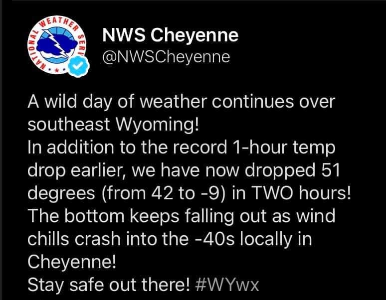
-
2022-2023 Fall/Winter Mountains Thread
Tyler Penland replied to BlueRidgeFolklore's topic in Southeastern States
Currently sitting at 32.9/21.3 Interesting night ahead with the ZR. Hopefully the roads are cleared up by the time folks get up. Sent from my Pixel 5 using Tapatalk -
Mid to Long Range Discussion ~ 2022
Tyler Penland replied to buckeyefan1's topic in Southeastern States
A 200 mile west shift at 5 days should almost be expected. Look what happened with the current system. This could easily NW trend itself into a decent storm. Or NW trend itself into a cutter. Sent from my Pixel 5 using Tapatalk -
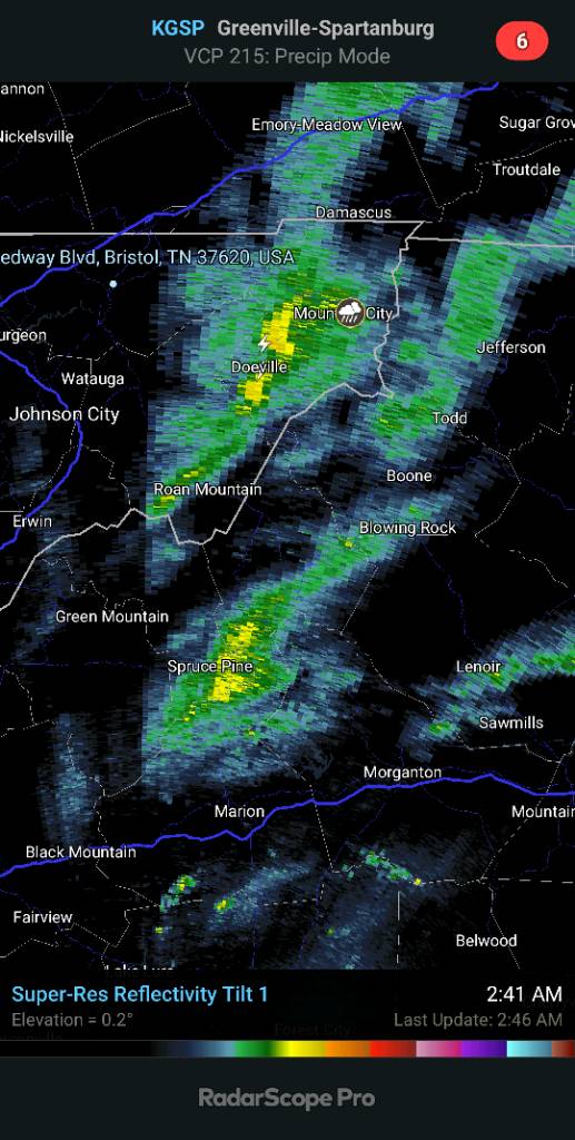
2022-2023 Fall/Winter Mountains Thread
Tyler Penland replied to BlueRidgeFolklore's topic in Southeastern States
Worth noting for the northern mountains at least the 3km NAM was a good improvement on snow. Basically no rain along the front just a snow squall. Sent from my Pixel 5 using Tapatalk -
2022-2023 Fall/Winter Mountains Thread
Tyler Penland replied to BlueRidgeFolklore's topic in Southeastern States
The HRRR is on drugs. Has Boone to -12 at the end of its run with a -39 wind chill. Sent from my Pixel 5 using Tapatalk -
2022-2023 Fall/Winter Mountains Thread
Tyler Penland replied to BlueRidgeFolklore's topic in Southeastern States
Yep pretty dry. Looks like a decent amount of moisture at 850mb behind the front. Should keep the NWFS going for a little while. Sent from my Pixel 5 using Tapatalk -
2022-2023 Fall/Winter Mountains Thread
Tyler Penland replied to BlueRidgeFolklore's topic in Southeastern States
Looking at the 3km NAM a quick change to snow with the actual frontal passage appears pretty likely. I'm concerned it'll be a bit moisture starved but ratios will go from 0-100 real quick. Sent from my Pixel 5 using Tapatalk -
2022-2023 Fall/Winter Mountains Thread
Tyler Penland replied to BlueRidgeFolklore's topic in Southeastern States
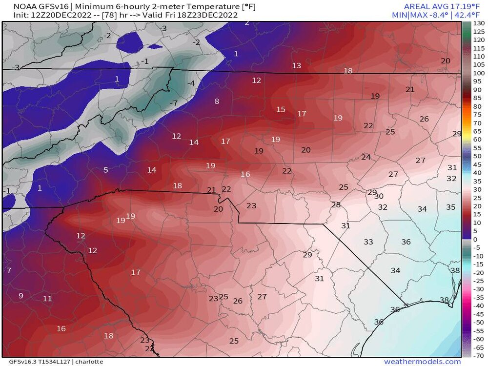
New minimum for Boone on the 12z GFS is -7. I'm curious to see if this verifies or not. The Euro is about 10 degrees warmer. Sent from my Pixel 5 using Tapatalk