

Damage In Tolland
-
Posts
116,809 -
Joined
Content Type
Profiles
Blogs
Forums
American Weather
Media Demo
Store
Gallery
Everything posted by Damage In Tolland
-

Augdewst 2026: Summer's Last Stand
Damage In Tolland replied to Prismshine Productions's topic in New England
Probably lost control of a chainsaw -
Augdewst 2026: Summer's Last Stand
Damage In Tolland replied to Prismshine Productions's topic in New England
Yikes on those feet -
Augdewst 2026: Summer's Last Stand
Damage In Tolland replied to Prismshine Productions's topic in New England
Dews being picked up -
Augdewst 2026: Summer's Last Stand
Damage In Tolland replied to Prismshine Productions's topic in New England
Some summers they do do start early . Some years they stop as fall arrives. And others all hell breaks loose -
Augdewst 2026: Summer's Last Stand
Damage In Tolland replied to Prismshine Productions's topic in New England
No these are medium sized acorns. Coming off the Red Oaks . -
Augdewst 2026: Summer's Last Stand
Damage In Tolland replied to Prismshine Productions's topic in New England
Monday kind of meh’ing out -
Augdewst 2026: Summer's Last Stand
Damage In Tolland replied to Prismshine Productions's topic in New England
We named it Augdewst for a reason -
Augdewst 2026: Summer's Last Stand
Damage In Tolland replied to Prismshine Productions's topic in New England
Does anyone else have acorns coming down ? Medium sized green ones . Started a few weeks ago and getting worse which means anger -
Augdewst 2026: Summer's Last Stand
Damage In Tolland replied to Prismshine Productions's topic in New England
Dew dew dew da da da da !! -
Augdewst 2026: Summer's Last Stand
Damage In Tolland replied to Prismshine Productions's topic in New England
He found one in the bathtub trying to turn the spigot on? -
Augdewst 2026: Summer's Last Stand
Damage In Tolland replied to Prismshine Productions's topic in New England
Looking for water? None around -
Augdewst 2026: Summer's Last Stand
Damage In Tolland replied to Prismshine Productions's topic in New England
Folks should listen instead of posting silly blue maps and charts . Fire up your Muggy meters and enjoy !!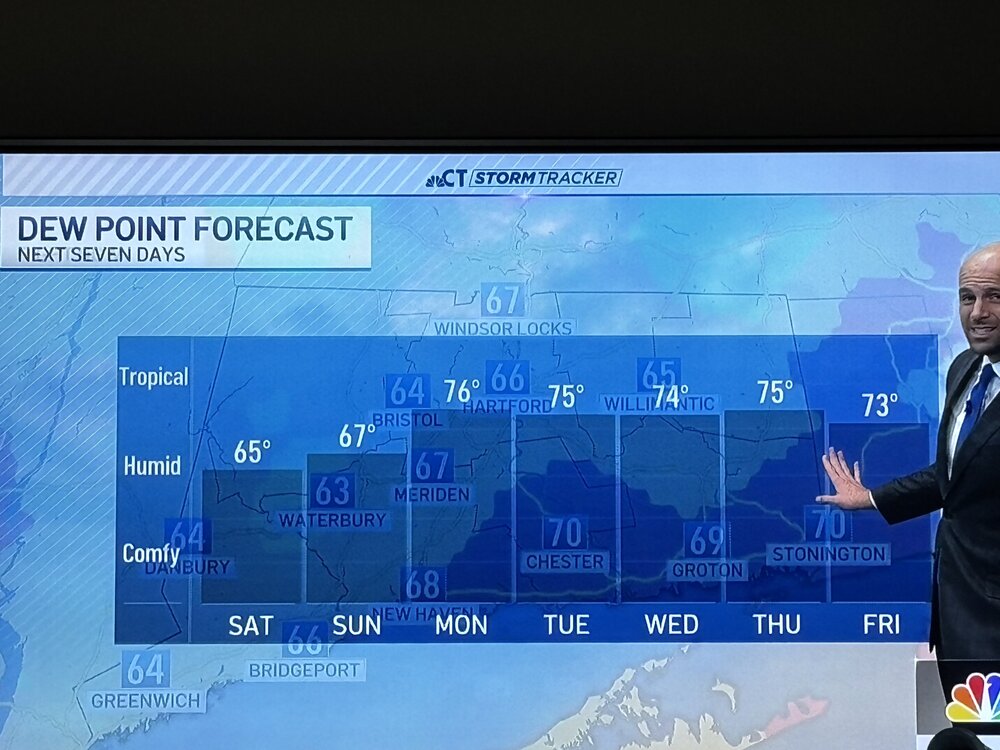
-
Augdewst 2026: Summer's Last Stand
Damage In Tolland replied to Prismshine Productions's topic in New England
At least the first 2 weeks look AN and humid. WAR -
Augdewst 2026: Summer's Last Stand
Damage In Tolland replied to Prismshine Productions's topic in New England
Sunrise surprise Monday -
Very gentle shower earlier dropped .10 of bore
-
Augdewst 2026: Summer's Last Stand
Damage In Tolland replied to Prismshine Productions's topic in New England
Folks were warned . Several weeks ago . Even some Mets said no .We said yes -
Moving due south down the valley. What a year for the CTRV. Rare
-
Monday seems kind of meh
-
Weeks and weeks of muggy meter
-
Is there anywhere you can get under to ensure safety?
-
Augdewst 2026: Summer's Last Stand
Damage In Tolland replied to Prismshine Productions's topic in New England
Whole month overall looks warmish with war near EC. Any cooling will be mainly west of apps -
Qpf wise seems like it does favor those same general areas that have had it all month . Might be like a Philly to W CT up to ORH special . Just hoping at least it’s with convection. I know you need the rain , but these boring rain events just provide no excitement
-
Hopefully Monday at least offers storm threat and not another boring 1-4” inch rainer . Doesn’t even have to be severe. Just give some thunder chances
-
Augdewst 2026: Summer's Last Stand
Damage In Tolland replied to Prismshine Productions's topic in New England
Warm, wet , and dewy the first two weeks of Augdewst. Signals are there dew friends.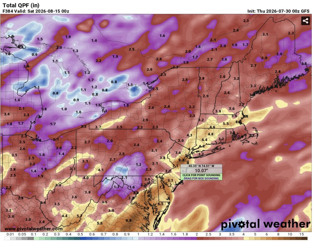
-
Did you attend as a young boy/camper/scout?


