bearman
-
Posts
716 -
Joined
-
Last visited
Content Type
Profiles
Blogs
Forums
American Weather
Media Demo
Store
Gallery
Everything posted by bearman
-

January 15th-17th 2024 Arctic Blast/Snow Event
bearman replied to John1122's topic in Tennessee Valley
One thing I like about this forum is how everyone treats each other with respect. You can be someone like me that has just enough knowledge to make me dangerous, all the way up to pro mets or their equivalent like @energyjeff and Carver. It’s a real prize and we all need to guard ourselves always making sure we treat each other as we want to be treated. Keep it up and lets get this storm dialed in. As an aside. I think it is even more impressive that our forum is such a good space besides the fact that we have so so much disappointments with all the different mico-climates. -
January 15th-17th 2024 Arctic Blast/Snow Event
bearman replied to John1122's topic in Tennessee Valley
Well, here we are sitting before a possible historic storm especially when you consider the temps behind the storm. So being who I am, I am always thinking about what could go wrong. I don’t have the expertise to get into the technical details but I remember one particular painful fail that took place @ least 15 or 20 years ago. I lived in Athens and Neal Pascal was the meteorologist @ channel 9 in Chattanooga, a very good Met. We had WSW over the entire area. Everyone was sure we were going to get many inches. I watched the Radar as it approached and a few flakes started coming down I expected the lower Atmosphere to quickly saturate and we would be in business. I waited and waited and waited. I never saw another flake all day. We had a huge snowstorm that never reached the ground. There was high pressure to the north that just kept feeding the dry air into the lower levels, at least that is how I understand it, and the moisture could never overcome it. This was the biggest bust ever remembered and excuses were flying This storm however is going to move forward because it is our time. -
January 15th-17th 2024 Arctic Blast/Snow Event
bearman replied to John1122's topic in Tennessee Valley
What is the light snow coming in to West TN and Southern KY. associated with.
-
January 15th-17th 2024 Arctic Blast/Snow Event
bearman replied to John1122's topic in Tennessee Valley
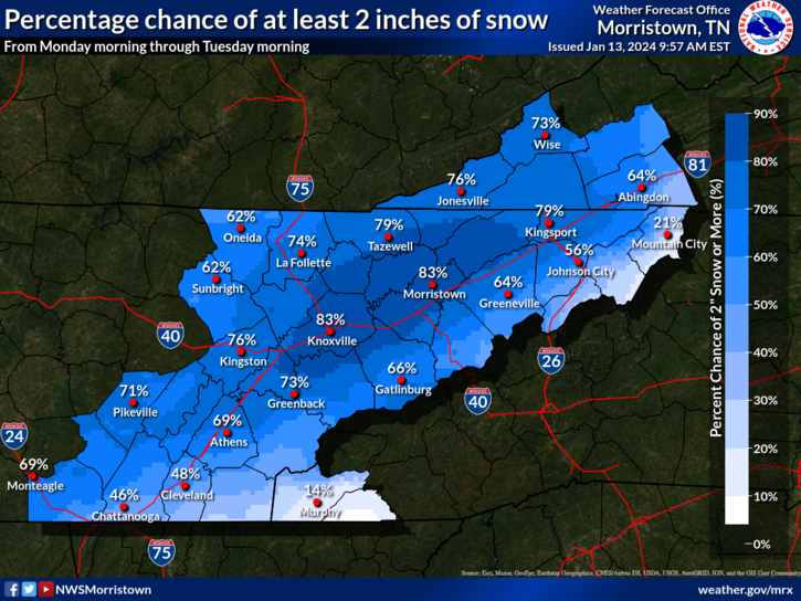
GOING CONSERVATIVE ON SNOW TOTALS This is typical. MRX at least. They will pick the most consevative model and cut that in half. Or they will go the other direction in rare occations especially if they have late in the game issued an advisory. They will keep totals going without any chance. Seen it both ways. -
January 15th-17th 2024 Arctic Blast/Snow Event
bearman replied to John1122's topic in Tennessee Valley
Wowza!
-
January 15th-17th 2024 Arctic Blast/Snow Event
bearman replied to John1122's topic in Tennessee Valley
What are the general timeframes for issuing warnings? -
January 15th-17th 2024 Arctic Blast/Snow Event
bearman replied to John1122's topic in Tennessee Valley
-
January 15th-17th 2024 Arctic Blast/Snow Event
bearman replied to John1122's topic in Tennessee Valley
No they don’t and that has me a little disconcerted I am right on the line in West Knox and that gives me maybe 2 in. -
January 15th-17th 2024 Arctic Blast/Snow Event
bearman replied to John1122's topic in Tennessee Valley
I think you are reading it right and neither is @energyJeff worried about mixing and I have a lot of confidence in his thoughts. -
January 15th-17th 2024 Arctic Blast/Snow Event
bearman replied to John1122's topic in Tennessee Valley
-
January 15th-17th 2024 Arctic Blast/Snow Event
bearman replied to John1122's topic in Tennessee Valley
Can someone post those latest maps? We are all getting whiplash. -
January 15th-17th 2024 Arctic Blast/Snow Event
bearman replied to John1122's topic in Tennessee Valley
I always tell myself not to get excited until the snow is falling.
-
January 15th-17th 2024 Arctic Blast/Snow Event
bearman replied to John1122's topic in Tennessee Valley
I guess someone has to live on the knifes edge.
-
January 15th-17th 2024 Arctic Blast/Snow Event
bearman replied to John1122's topic in Tennessee Valley
Is this projection or does he know us all too well or is it both.? -
January 15th-17th 2024 Arctic Blast/Snow Event
bearman replied to John1122's topic in Tennessee Valley
Models have been very consistent and I like it. I know that there is a million ways we can get the screw job but it we do we will survive. It is however time for us to get a storm like this, it has been a minute. -
January 15th-17th 2024 Arctic Blast/Snow Event
bearman replied to John1122's topic in Tennessee Valley
I like the low way up in Canada. Lets all set up a time to mind link to it and make it rotate around our area about 3 times and we will all be ready for spring. -
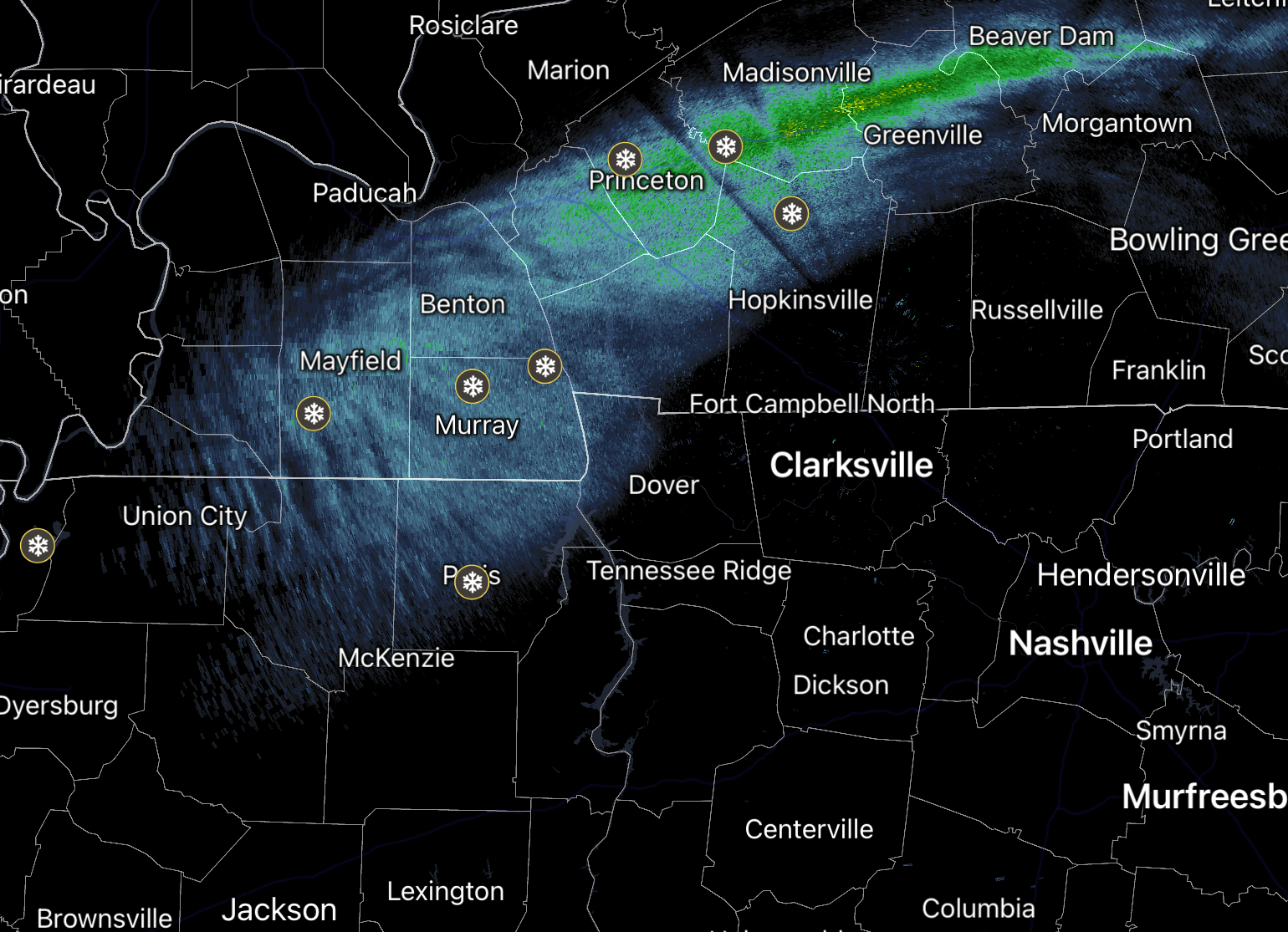
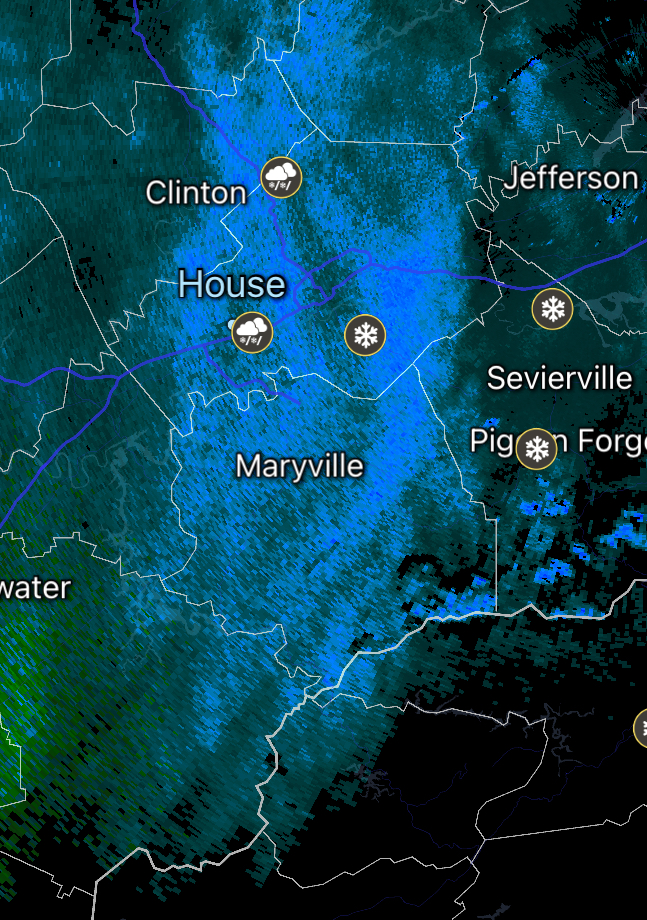
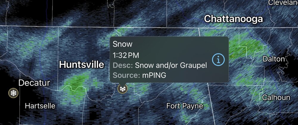
Looks like there are a few flakes showing up in North AL and North GA.
-
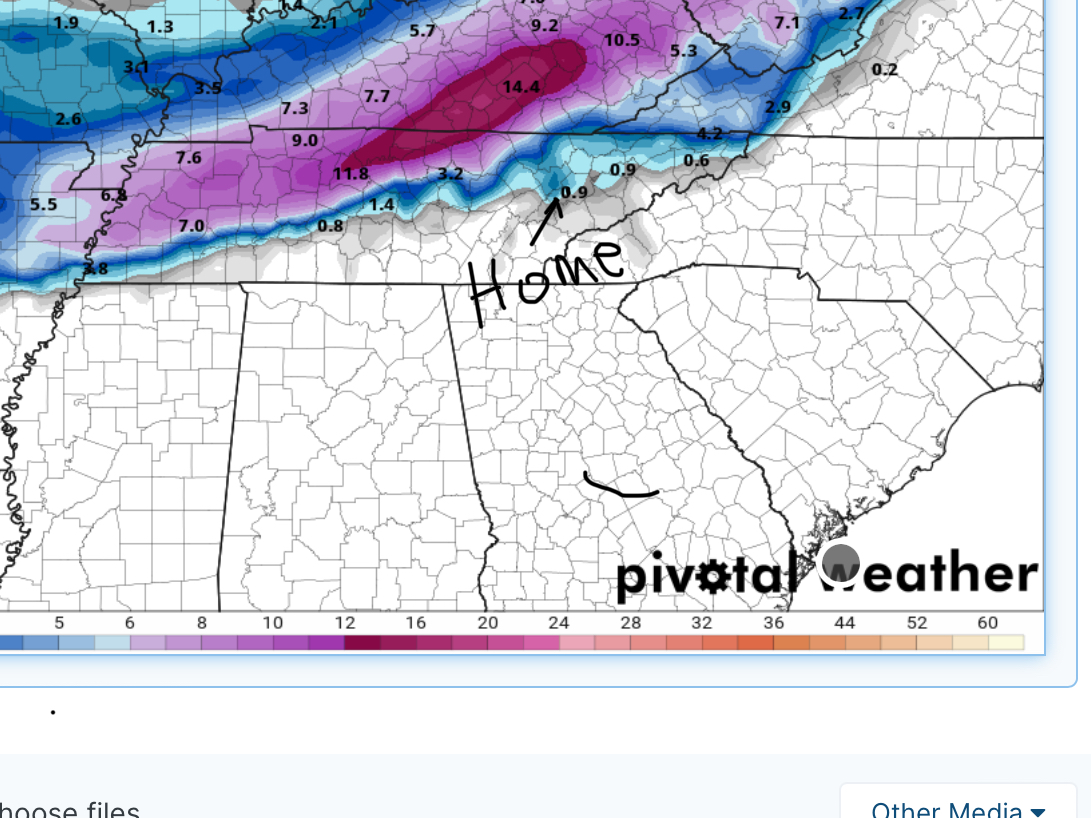
We finally have some returns over our area but nothing is falling from the sky. I have had no winter type precipitation fall this year except a few wet flakes this morning. Sad times for snow lovers. Maybe we can get somthing going next week.
-
December 2023 Mid/Long Term Pattern Discussion: Let it Snow!
bearman replied to John1122's topic in Tennessee Valley
It is pretty rare that we get suprises. When I was a kid there was nothing more exciting to me than waking up in the morning with that insulated feeling that you get on the house from an unexpected snowfall covering the roof and running to look out the window to see if I was interpreting the feelings correctly. I think the surprise was always the best part of the experience. Sorry should be puting this in banner. -
January Medium-Long Range Discussion
bearman replied to Holston_River_Rambler's topic in Tennessee Valley
First soggy flury of the year just came by the house.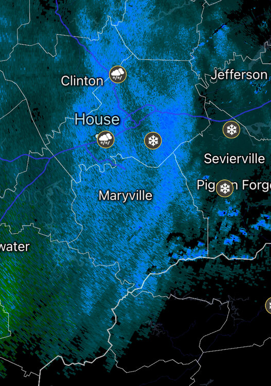
-
Story of my life. I expect to have a mob of crazed weather freaks with pitchforks and shovels intent on driving back south.
-
It is really funny. I hate to be a weenie but why not? I lived in the Cleveand area for years and it seemed the tri-cites and Knoxville areas would get these backside snows almost every winter. Something that never happened in Southeast TN. I then moved up to Knoxville about 15 years ago and we have got almost none of these clippers since I have moved, at least none that have amounted to anything. Is this the case or am I just imagining this?
-
Not your fault nothing can overcome heat blister in the TN Valley.


-
Fall/Winter Banter - Football, Basketball, Snowball?
bearman replied to John1122's topic in Tennessee Valley
Sighs of fun to come. At least we can dream. Snow flying up on the mountain tops of West Va. https://www.snowshoemtn.com/media-room/boathouse-and-ballhooter-lift-live-cam -
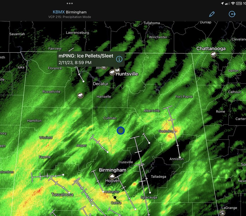
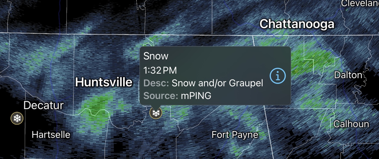
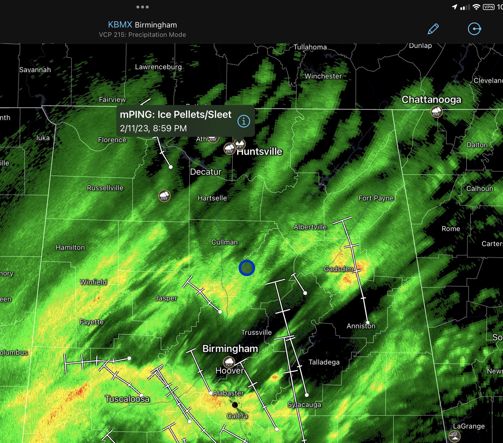
More sleet and ice pellets near Huntsville. Don’t know if it means anything.