

Jackstraw
-
Posts
2,592 -
Joined
-
Last visited
Content Type
Profiles
Blogs
Forums
American Weather
Media Demo
Store
Gallery
Everything posted by Jackstraw
-
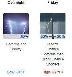
Random sampling always a good thing.
-
Hate to admit a poor choice from my youth, a weekend in the county jail back in the early 80's , but that's how you kept a cigarette lit back when you could smoke but they wouldn't let you have a source of ignition, toss it from cell block to cell block to cell block 24/7. Newbies pulled the longest shifts. God forbid if it went out on your watch lol.
-
US hit 100 deaths in 24 hours for the first time.
-
Buckle up folks. I think the next 7-10 days are going to be the true test of peoples nerves. I hope people will keep their heads but from my experience in hurricane disasters its the period between 2 and 3 weeks where people start getting edgy. I honestly don't know how sustainable our current actions are either economically or socially.
-
I lived in California then, duck and cover lol.
-
Also, I'm not gonna go into the reaction here in Mayberry but it's ridiculous. Focus has been on the big metro centers but there are a gazzilion Mayberry's across this country. Nothing is more corrupt than Mayberry politics and this thing is just now starting to hit the Mayberry's of this country. 7-14 days shits gonna start hitting the proverbial fan, especially in the Mayberry's. The current reaction is just not sustainable, especially in Mayberry.
-
We're all gonna get it eventually. We know these precautions are just to keep the medical infrastructure from being overwhelmed. My issue is that the richest country in the world isn't prepared to treat .02%, yes POINT zero two percent, of its population in a trauma ICU situation. .02%, thats just nuts.
-
Lmfao! How many commercials do we have to see and say "hey I got that" lol. RLS? Toe fungus? 100 different ways to be depressed and medicated? Malvina had it right a long time ago the year I was born lol.... https://www.youtube.com/watch?v=VUoXtddNPAM
-
Thought I saw Vinny Barbarino in that bubble lol
-
Always an alternative
-
I was astonished. I didn't realize this was a country of aristocrats... https://www.cnn.com/2020/03/21/health/how-to-cook-from-home-coronavirus-drayer-wellness/index.html
-
I hear ya but the "olds"? Lmao, I'm a year away from being the "olds".
-
So did IL issue a "Stay at Home" order or to SIP? There's a big difference.
-
Very hard to do? How about impossible lol
-
If you're staying home whether self induced or just trying to be socially responsible and want to geek out about this here ya go. It's a worthwhile internet rabbit hole to dive in to. If you can skim through some of the geek speak you can get a feel of how this came about, the groundhog day "we seen this before", and how far behind the information cycle we're being fed is from fact. Trust me if you have trouble sleeping like me this stuff is better than counting coronaviruses lol...... http://www.cidrap.umn.edu/infectious-disease-topics/covid-19#bibliography&1-7
-
Gotta love a P&C like this lol.....
-
Those are valid questions to my post and I guess one thing I should've clarified was when I said our medical infrastructure and system I was in no means singling out all of the medical professionals from researchers to doctors, nurses or hospitals. My take on medical infrastructure and medical system runs the gamut from federal to state and local governments to private entities. It is absolutely ridiculous to rely on one or some of each of those when there is a pathogenic pandemic affecting the entire social spectrum. Our medical infrastructure was and is woefully unprepared to handle this. The medical community (not the infrastructure) has been worried about this for over 30 years. Numerous studies and reports have been presented that we as a country and even as a world society are not prepared for a planet wide pandemic, including the John Hopkins report in 2018 which got shoved under the rug. Since this is mainly a weather board I was just trying to use the way we learned to become proactive instead of reactive to severe weather events to state how we should use that same approach when it comes to biological threats. I would've thought, especially after 9/11, our medical infrastructure would've been better prepared for a biological threat, be it terrorism or natural. My spouse and I have worked in the medical community for over 25 years and I will tell you this is one of the biggest fears from medical professionals I've heard over the years. This is the same stuff I heard when I lived in hurricane country 30 years ago, the big ones gonna happen and we're not ready, hence my loose analogy that hopefully this is the pathogenic Hugo. One fact I think people don't quite understand. The population of this planet has nearly doubled in the last 50 years. Half of that new population lives in densely packed environments. The odds of a zoonotic virus making its way into the human population have increased 100 fold over the last 50 years. We've now had a consistent outbreak of these viruses every 7-10 years for the last 40 years. Luckily, most of them haven't been as contagious as this one from a human to human standpoint. It's really simple math. Hindsight's 20-20 sure but my hope is, like the lessons learned from violent weather as populations increase and become more vulnerable, we can move forward with a better understanding of our own arrogance here and take measures to be proactive instead of reactive to something that can affect so many people in such a short period of time.
-
I don't believe a thing that China reports. This is going to come in waves until if/when we have an effective vaccine. Just like violent weather the best thing we can do is be prepared, which this show's we're woefully not. Over the last 30- 40 years we've updated building codes, evacuation plans, invested in public awareness campaigns and in science (like anything now-a-days not enough there) in hurricane prone areas from lessons learned since Cammile, Hugo, Andrew and Katrina all of which have undoubtedly saved thousands of lives. We've done very similar things when it comes to tornado outbreaks. Sure warning times have probably helped the most but without the investments in all of the above warning times would be much less effective. We can go spend 100's of billions to fill our emergency oil reserves during this yet our medical system and infrastructure is nowhere prepared. I kind of look at this as the biological Hugo. There's going to be another one, a biological Andrew, even a Katrina. Just like violent weather we know it's going to happen. Hopefully this will begin a trend to start investing in better "building codes", better "response plans", better "public awareness/education" and better "science" at a public health level. Nobody is 100% sure yet but more than likely this may eventually run it's course with time, maybe even a year or longer. But ones going to come along that is really a nasty one, that it is extremely resilient and resistant to whatever we throw at it. I hope it's not this one but when that bug comes around we better be a lot more prepared than we are now. Telling NY the big white ship with the big Red Cross is coming ain't cutting it
-
So much for social distancing, geez we've gone over the edge man.
-
No ball to watch on TV so I came across Mike Rowes (Dirty Jobs guy) "How Booze Built America". Explains everything going on today lol. Edit: I swear don't know how I missed this, it's the best show I've seen in ages. Maybe it was the booze lol.
-
I still don't understand, WHY toilet paper? I must be missing something lol.
-
I was a field service engineer for 10 years before my current job and was NEVER home, sometimes gone 2 or 3 weeks at a time. I got to travel all over the US and Canada which was great but I got so sick of living out of hotels and eating at restaurants besides being away from my wife and family for such long periods. Took my current job because it allowed me to be home and now the wife hates me lol. I work 90% from my home office, occasionally getting to go in for corporate crap or a rare customer onsite. My friends who go to a workplace say I have it made but it really is hard. When I said its not what it's cracked up to be is because working from home almost all the time requires a lot more discipline than most people realize. It's really easy to get distracted and complacent. Didn't take me long to figure that out. I built a shed away from the house that's my home office so I have some kind of "feel" like I'm going to work . I will admit, the 50 foot commute is pretty sweet lol.
-
Yes, they just closed schools here for the next month. I've worked from home for the last 6 years. Trust me it's not all it's cracked up to be. I agree with you about getting outside and enjoying life away from 4 walls be it a workplace and/or home. I do it just to maintain sanity. Heck I'll sleep out in the yard half the time in the summer lol. I agree with you about getting out and about. This may be a blessing for some if they do that and get them back in touch with parts of life that the rat race of modern life has taken away. Not likely to get sick in the woods! Actually I'm getting ready to go fishing at a local spot this morning for the first time in 2020. See if I can't coax me out some slow moving snow bass lol
-
Heard the Gov. of NY say the best way to control this is testing and to isolate the "positive's". That's all we need, a label for those infected geez. Like ShaumburgStormer posted, these precautions are being implemented to protect those most vulnerable, mainly infants, folks with for whatever reason have a depressed immune system and those over 60, of which we have one of the largest elderly populations in US history right now. That's also a big difference from say 1918, there's a lot more vulnerable today. On one of the flying channels on youtube I watch the guy had a Physician/pilot on there that gave a very balanced discussion on what's going on, which is extremely difficult to filter through with all the crap out there. Some of the things he brought up made very good sense. The fact that those who do pass from this die from pneumonia, and it is a viral pneumonia so antibiotics don't help. He stated the mortality rate from this is around 3% where as the 1918 was around 2% without the advances in medical care we have now. The one thing he said that struck me is that within the medical community the biggest fear is its going to settle down as we enter the summer but when we get back into the colder months next fall it very likely is going to come back with a vengeance. The only way to truly control it is via vaccinations so the body can defend itself of which may not be available until late fall early winter. I'm not in a high risk category so honestly I wouldn't be too concerned if I contracted it now, while I'm healthy than take a chance on next winter when something could happen to me health wise to compromise my immune system before a vaccine is available, my body would be ready. Here's a link to that interview plus if your into GA and flying this guys got a great channel....
-
No tournament . Can I trade my beer stock for toilet hand paper sanitizer? Honestly, and maybe I'm just an old ****, but I think there's a bit of over reaction going on. My biggest concern is somebody is going to supposedly get someone else mortally sick and relatives or even government are going to go after them. We don't need anymore division in this country. Was already a fight locally over the last couple gallons of bleach at the local store. I mean c'mon.


