
snowlover2
-
Posts
2,731 -
Joined
-
Last visited
Content Type
Profiles
Blogs
Forums
American Weather
Media Demo
Store
Gallery
Posts posted by snowlover2
-
-
23 minutes ago, Hoosier said:
18z NAM is coming in pretty nice for you guys to my east.
Problem is temps are above freezing until monday evening.
-
-
0z GGEM also a big hit for Ohio.
-
73mph winds near Winnebago IL.
QuoteSevere Weather Statement National Weather Service Chicago/Romeoville 341 PM CST Tue Nov 10 2020 ILC007-037-103-141-201-102230- /O.CON.KLOT.SV.W.0105.000000T0000Z-201110T2230Z/ Lee IL-Ogle IL-De Kalb IL-Winnebago IL-Boone IL- 341 PM CST Tue Nov 10 2020 ...A SEVERE THUNDERSTORM WARNING REMAINS IN EFFECT UNTIL 430 PM CST FOR EASTERN LEE...EASTERN OGLE...DE KALB...WINNEBAGO AND BOONE COUNTIES... At 340 PM CST, severe thunderstorms were located along a line extending from near Durand to Rockford to Amboy, moving northeast at 65 mph. HAZARD...70 mph wind gusts and penny size hail. SOURCE...Trained weather spotters. 73 mph gust observed in Winnebago at 332 PM CST. IMPACT...Expect considerable tree damage. Damage is likely to mobile homes, roofs, and outbuildings. Locations impacted include... Rockford, DeKalb, Belvidere, Loves Park, Machesney Park, Sycamore, Roscoe, Rochelle, South Beloit, Rockton, Poplar Grove, Genoa, Shabbona, Rockford Airport, Candlewick Lake, Cortland, Cherry Valley, Winnebago, Davis Junction and Pecatonica. -
If i had only gone higher on the total number of storms.
-
 1
1
-
-
10 minutes ago, hawkeye_wx said:
The GFS continues to tease snow events for the upper midwest in the 1-2 week period. Last night's Euro had a good one up in Minnesota.
At the very least, it appears the garden season will be over.
GFS fantasy games had to start at some point.
-
1
-
-
Quote
URGENT - IMMEDIATE BROADCAST REQUESTED
   Severe Thunderstorm Watch Number 431
   NWS Storm Prediction Center Norman OK
   805 PM EDT Mon Aug 10 2020

   The NWS Storm Prediction Center has issued a

   * Severe Thunderstorm Watch for portions of
     Extreme southeastern Indiana
     Extreme north central Kentucky
     Western Ohio
     Lake Erie

   * Effective this Monday night and Tuesday morning from 805 PM
     until 100 AM EDT.

   * Primary threats include...
     Scattered damaging wind gusts to 70 mph possible
     Isolated large hail events to 1 inch in diameter possible

   SUMMARY...A well-developed squall line will likely persist for a few
   more hours while moving from Indiana into western Ohio and northern
   Kentucky.  The threat for occasional damaging gusts will likewise
   continue, until the storms weaken later tonight.

   The severe thunderstorm watch area is approximately along and 40
   statute miles east and west of a line from 15 miles north northwest
   of Toledo OH to 50 miles south southwest of Cincinnati OH. For a
   complete depiction of the watch see the associated watch outline
   update (WOUS64 KWNS WOU1).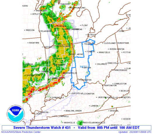
-
Um Wow! Indy under a warning for a storm moving 90mph!
QuoteBULLETIN - IMMEDIATE BROADCAST REQUESTED Severe Thunderstorm Warning National Weather Service Indianapolis IN 736 PM EDT Mon Aug 10 2020 The National Weather Service in Indianapolis has issued a * Severe Thunderstorm Warning for... Southern Madison County in central Indiana... Hancock County in central Indiana... Marion County in central Indiana... Southeastern Hamilton County in central Indiana... * Until 800 PM EDT. * At 735 PM EDT, a severe thunderstorm was located near Lawrence, or 10 miles east of Indianapolis, moving east at 90 mph. HAZARD...70 mph wind gusts. SOURCE...Radar indicated. IMPACT...Expect considerable tree damage. Damage is likely to mobile homes, roofs, and outbuildings. * Locations impacted include... Indianapolis, Carmel, Fishers, Lawrence, Greenfield, Beech Grove, Speedway, Cumberland, McCordsville, Pendleton, Fortville, Ingalls, New Palestine, Meridian Hills, Warren Park, Rocky Ripple, Markleville, Wilkinson, Williams Creek and Wynnedale. This includes the following highways... Interstate 65 between mile markers 107 and 120. Interstate 69 between mile markers 200 and 210. Interstate 70 between mile markers 74 and 112. Interstate 74 between mile markers 73 and 96.-
 1
1
-
-
Tornado warning for Fort Wayne.
QuoteBULLETIN - EAS ACTIVATION REQUESTED Tornado Warning National Weather Service Northern Indiana 711 PM EDT Mon Aug 10 2020 The National Weather Service in Northern Indiana has issued a * Tornado Warning for... Southwestern Allen County in northeastern Indiana... Southern Whitley County in northeastern Indiana... Northern Huntington County in northeastern Indiana... * Until 745 PM EDT. * At 711 PM EDT, a severe thunderstorm capable of producing a tornado was located 7 miles south of Columbia City, moving east at 55 mph. HAZARD...Tornado. SOURCE...Radar indicated rotation. IMPACT...Flying debris will be dangerous to those caught without shelter. Mobile homes will be damaged or destroyed. Damage to roofs, windows, and vehicles will occur. Tree damage is likely. * This dangerous storm will be near... New Haven around 740 PM EDT. Other locations impacted by this tornadic thunderstorm include Laud, Nine Mile, Yoder, Dunfee, Poe, Aboite, Goblesville, Hessen Cassel, Roanoke and Coesse. This includes the following highways... Interstate 469 between mile markers 0 and 17, and between mile markers 23 and 30. Interstate 69 in Indiana between mile markers 296 and 314. -
Tornado warning west of Fort Wayne.
QuoteBULLETIN - EAS ACTIVATION REQUESTED Tornado Warning National Weather Service Northern Indiana 641 PM EDT Mon Aug 10 2020 The National Weather Service in Northern Indiana has issued a * Tornado Warning for... Southern Elkhart County in north central Indiana... Southeastern St. Joseph County in north central Indiana... Northeastern Kosciusko County in north central Indiana... * Until 700 PM EDT. * At 640 PM EDT, a severe thunderstorm capable of producing a tornado was located over Wakarusa, or near Nappanee, moving east at 50 mph. HAZARD...Tornado. SOURCE...Radar indicated rotation. IMPACT...Flying debris will be dangerous to those caught without shelter. Mobile homes will be damaged or destroyed. Damage to roofs, windows, and vehicles will occur. Tree damage is likely. * This dangerous storm will be near... Milford and New Paris around 650 PM EDT. Goshen around 655 PM EDT. Syracuse and Millersburg around 700 PM EDT. Other locations impacted by this tornadic thunderstorm include Southwest, Foraker, Gravelton, Locke, Benton, Oakwood Park and Waterford Mills. -
Watches farther east sound like they are coming.
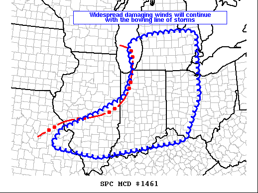
QuoteMesoscale Discussion 1461 NWS Storm Prediction Center Norman OK 0517 PM CDT Mon Aug 10 2020 Areas affected...southern lower Michigan...Indiana...southern Illinois...east-central Missouri...northern Kentucky...and western Ohio Concerning...Severe Thunderstorm Watch 428...429... Valid 102217Z - 110015Z The severe weather threat for Severe Thunderstorm Watch 428, 429 continues. SUMMARY...Widespread damaging wind gusts will continue across WW 428 and 429, and eventually will spread into adjacent/downstream areas. One or more new WW issuances may be needed to cover the fast-moving threat. DISCUSSION...Latest radar loop shows a well-defined bowing MCS moving quickly eastward/southeastward at 40 to 45 kt across the Midwest, with the main convective line now east of Chicago, and moving toward Grand Rapids/Indianapolis/St. Louis. While moderate instability remains just downstream of the convection, which will allow storms to remain intense over the next hour, instability lessens with eastward and southeastward extent east of the existing watches. Still, given the very well-organized nature of this convective system, an organized/bowing band is likely to continue east and southeast of the existing watches. While severe risk should begin to diminish/become more isolated this evening, a new WW issuance -- into eastern lower Michigan and western Ohio, may be required. Some risk may also spread southeast of the existing watches across the Ohio River into northern Kentucky as well --- which could also require WW consideration. ..Goss.. 08/10/2020
-
2
-
-
Tornado warning north side of Chicago.
QuoteBULLETIN - EAS ACTIVATION REQUESTED Tornado Warning National Weather Service Chicago/Romeoville 343 PM CDT Mon Aug 10 2020 The National Weather Service in Chicago has issued a * Tornado Warning for... Northeastern DuPage County in northeastern Illinois... Northeastern Cook County in northeastern Illinois... * Until 430 PM CDT. * At 342 PM CDT, a severe thunderstorm capable of producing a tornado was located over Elmhurst, moving east at 50 mph. HAZARD...Tornado. SOURCE...Radar indicated rotation. IMPACT...Flying debris will be dangerous to those caught without shelter. Mobile homes will be damaged or destroyed. Damage to roofs, windows, and vehicles will occur. Tree damage is likely. * This dangerous storm will be near... Norridge, Elmwood Park, River Forest and River Grove around 350 PM CDT. Oak Park, Austin, Dunning, Portage Park, Belmont Cragin, Morton Grove and Harwood Heights around 355 PM CDT. Irving Park, West Town, West Ridge, Albany Park, Logan Square, Humboldt Park and Lincolnwood around 400 PM CDT. Chicago, Evanston, Lake View, Lincoln Park, Uptown, Rogers Park and Edgewater around 405 PM CDT. Other locations impacted by this tornadic thunderstorm include Jefferson Park, Stone Park, North Park, Golf, Forest Glen, North Center, Berkeley, Lincoln Square, Medinah and York Center. This includes... Lincoln Park Zoo, Loyola University, Oakton Community College, Triton College, Northeastern Illinois University, Northwestern University, and Wrigley Field. Including the following interstates... I-88 near mile marker 140. I-90 between mile markers 72 and 84. I-94 between mile markers 31 and 48. I-290 between mile markers 3 and 16. I-294 between mile markers 31 and 48. I-355 between mile markers 27 and 30. -
Quote
 URGENT - IMMEDIATE BROADCAST REQUESTED
   Severe Thunderstorm Watch Number 429
   NWS Storm Prediction Center Norman OK
   425 PM EDT Mon Aug 10 2020

   The NWS Storm Prediction Center has issued a

   * Severe Thunderstorm Watch for portions of
     Northern and central Indiana
     Southwest Lower Michigan
     Far northwest Ohio
     Lake Michigan

   * Effective this Monday afternoon from 425 PM until Midnight EDT.

   * Primary threats include...
     Scattered damaging winds and isolated significant gusts to 80
       mph likely
     A tornado or two possible

   SUMMARY...A long-lived bowing MCS, that appears to have peaked in
   terms of intensity and amplitude of significant severe wind gusts,
   will likely produce scattered damaging winds and isolated
   significant severe gusts as it spreads into Lower Michigan and
   Indiana this evening.

   The severe thunderstorm watch area is approximately along and 60
   statute miles east and west of a line from 40 miles east northeast
   of Muskegon MI to 20 miles south southwest of Indianapolis IN. For a
   complete depiction of the watch see the associated watch outline
   update (WOUS64 KWNS WOU9).

   PRECAUTIONARY/PREPAREDNESS ACTIONS...

   REMEMBER...A Severe Thunderstorm Watch means conditions are
   favorable for severe thunderstorms in and close to the watch area.
   Persons in these areas should be on the lookout for threatening
   weather conditions and listen for later statements and possible
   warnings. Severe thunderstorms can and occasionally do produce
   tornadoes.

   &&

   OTHER WATCH INFORMATION...CONTINUE...WW 426...WW 427...WW 428...

   AVIATION...A few severe thunderstorms with hail surface and aloft to
   1 inch. Extreme turbulence and surface wind gusts to 70 knots. A few
   cumulonimbi with maximum tops to 550. Mean storm motion vector
   27050.

   ...Grams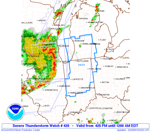
-
Quote
BULLETIN - EAS ACTIVATION REQUESTED Tornado Warning National Weather Service Chicago/Romeoville 255 PM CDT Mon Aug 10 2020 The National Weather Service in Chicago has issued a * Tornado Warning for... Northern Boone County in north central Illinois... * Until 345 PM CDT. * At 255 PM CDT, a severe thunderstorm capable of producing a tornado was located near Loves Park, moving northeast at 30 mph. HAZARD...Tornado. SOURCE...Radar indicated rotation. IMPACT...Flying debris will be dangerous to those caught without shelter. Mobile homes will be damaged or destroyed. Damage to roofs, windows, and vehicles will occur. Tree damage is likely. * This dangerous storm will be near... Candlewick Lake and Timberlane around 305 PM CDT. Poplar Grove around 310 PM CDT. Capron around 320 PM CDT. Other locations impacted by this tornadic thunderstorm include Caledonia. -
Only change from SPC on 20z outlook was to trim the west side of the risk areas where storms have already passed.
-
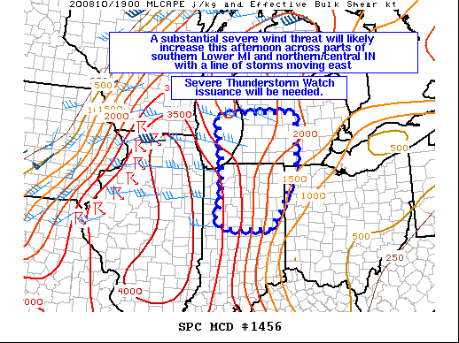
Watch coming for SW MI/IN.
QuoteMesoscale Discussion 1456 NWS Storm Prediction Center Norman OK 0228 PM CDT Mon Aug 10 2020 Areas affected...Portions of southern Lower MI into northern/central IN and far northwestern OH Concerning...Severe potential...Severe Thunderstorm Watch likely Valid 101928Z - 102100Z Probability of Watch Issuance...95 percent SUMMARY...A substantial severe wind threat will likely increase this afternoon across parts of southern Lower Michigan and into northern/central Indiana with a line of storms moving quickly eastward. A Severe Thunderstorm Watch will be needed. DISCUSSION...A bow echo will continue moving rapidly eastward across northern IL and far southern WI this afternoon while producing widespread damaging winds of 70-100 mph. The airmass across southern Lower MI and northern/central IN continues to destabilize this afternoon, with surface temperatures having warmed into the mid to upper 80s, and surface dewpoints in the low to mid 70s. Steeper mid-level lapse rates observed on the 18Z ILX sounding have likely spread over at least the western portions of southwestern MI and western IN. Resultant MLCAPE of 2000-3500 J/kg and around 25-30 kt of effective bulk shear will likely support the maintenance of the severe bow echo as it moved eastward across these areas this afternoon and early evening. Severe wind gusts, some 75+ mph, will likely produce numerous to widespread damaging winds, and a tornado or two cannot be ruled out with circulations embedded within the line. This substantial severe wind risk is expected to increase within the next couple of hours, and a Severe Thunderstorm Watch will be issued to address this threat. ..Gleason/Grams.. 08/10/2020
-
2
-
-
New tornado warning in south WI.
QuoteBULLETIN - EAS ACTIVATION REQUESTED Tornado Warning National Weather Service Milwaukee/Sullivan WI 226 PM CDT Mon Aug 10 2020 The National Weather Service in Milwaukee/Sullivan has issued a * Tornado Warning for... Southeastern Green County in south central Wisconsin... Western Rock County in south central Wisconsin... * Until 315 PM CDT. * At 225 PM CDT, a severe thunderstorm capable of producing a tornado was located near Monroe, moving east at 25 mph. HAZARD...Tornado and quarter size hail. SOURCE...Radar indicated rotation. IMPACT...Flying debris will be dangerous to those caught without shelter. Mobile homes will be damaged or destroyed. Damage to roofs, windows, and vehicles will occur. Tree damage is likely. * Locations impacted include... Janesville, Beloit, Brodhead, Orfordville, Footville, Newark, Magnolia, Hanover, Leyden, Afton, Juda and Avon. -
Quote
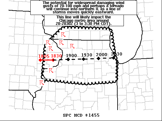
  Mesoscale Discussion 1455
   NWS Storm Prediction Center Norman OK
   0136 PM CDT Mon Aug 10 2020

   Areas affected...Portions of far eastern IA into southern WI and
   northern IL...including the Chicago metro

   Concerning...Severe Thunderstorm Watch 426...

   Valid 101836Z - 102030Z

   The severe weather threat for Severe Thunderstorm Watch 426
   continues.

   SUMMARY...The potential for widespread and destructive damaging wind
   gusts of 70-100+ mph and perhaps a tornado or two will continue as a
   line of storms moves quickly eastward across northern Illinois. This
   line will likely impact the Chicago metro area around 2000-2030Z (3
   to 3:30 PM CDT).

   DISCUSSION...The bow echo over eastern IA has developed a comma head
   structure on its northern flank and very large rear-inflow jet, with
   measured wind gusts of 97 and 112 mph recently reported in the
   vicinity of Cedar Rapids IA. The 17Z sounding from DVN observed
   steep 700-500 mb lapse rates of 8.5 C/km. These lapse rates combined
   with strong heating of a very moist low-level airmass is supporting
   3000-3500 J/kg of MLCAPE downstream of the bow. The 25 kt of
   effective bulk shear also observed on the 17Z sounding is somewhat
   marginal for storm organization. Regardless, with the bow echo
   already very well developed/organized, confidence remains high that
   a swath of widespread, destructive damaging winds of 70-100+ mph
   will sweep eastward across northern IL and vicinity over the next
   hour or two. If the current fast eastward motion of the bow (around
   60 kt) holds steady, then the widespread damaging wind threat will
   increase across the Chicago metro area by 2000-2030Z (3 to 3:30 PM
   CDT). In addition to the substantial straight-line wind threat, some
   increase in the tornado threat may be developing on the northern
   flank of the bow, where mid-level rotation has recently been noted.
   Other cells have also formed ahead of the line across far southern
   WI and northern IL along a weak warm front, and this convection will
   pose a threat for isolated large hail, damaging winds, and perhaps a
   tornado or two.

   ..Gleason.. 08/10/2020
-
 1
1
-
-
Couple of tornado warnings in SW WI on the north side of the bow.
-
Probabilities for the watch.
Tornadoes
Probability of 2 or more tornadoes Mod (40%)
Probability of 1 or more strong (EF2-EF5) tornadoes Low (20%)
Wind
Probability of 10 or more severe wind events High (90%)
Probability of 1 or more wind events > 65 knots High (90%)
Hail
Probability of 10 or more severe hail events Low (20%)
Probability of 1 or more hailstones > 2 inches Low (10%)
Combined Severe Hail/Wind
Probability of 6 or more combined severe hail/wind events High (>95%)
-
5 hours ago, Hoosier said:
Ohio governor tested positive but is currently asymptomatic
https://www.whio.com/news/local/gov-dewine-tests-positive-coronavirus/TSZIR6U735GZBGCORZ3TQ2SH6Y/
Second test he took this afternoon came back negative.
-
Looks like parts of IN/OH could see heavy rain to start the month.
-
4 hours ago, Hoosier said:
Statewide masking order goes into effect in Indiana on Monday for people over 8 years old. I am not sure where that particular number is coming from. I know there is some data out there to suggest that kids over age 10 and especially over age 15 are better at spreading the virus than younger kids.
Ohio goes under a statewide order at 6pm today for 10 year olds and older. Obvious exceptions for medical conditions and eating and drinking.
-
Confirmed tornado over Eau Claire WI.
QuoteSevere Weather Statement National Weather Service Twin Cities/Chanhassen MN 843 PM CDT Tue Jul 21 2020 WIC017-035-220200- /O.CON.KMPX.TO.W.0027.000000T0000Z-200722T0200Z/ Chippewa WI-Eau Claire WI- 843 PM CDT Tue Jul 21 2020 ...A TORNADO WARNING REMAINS IN EFFECT UNTIL 900 PM CDT FOR SOUTH CENTRAL CHIPPEWA AND NORTHWESTERN EAU CLAIRE COUNTIES... At 843 PM CDT, a confirmed tornado was located over Eau Claire, moving east at 20 mph. HAZARD...Damaging tornado. SOURCE...Weather spotters confirmed tornado. IMPACT...Flying debris will be dangerous to those caught without shelter. Mobile homes will be damaged or destroyed. Damage to roofs, windows, and vehicles will occur. Tree damage is likely. This tornado will be near... Lake Wissota around 850 PM CDT. Other locations impacted by this tornadic thunderstorm include Bateman, Eau Claire Airport and Seymour.
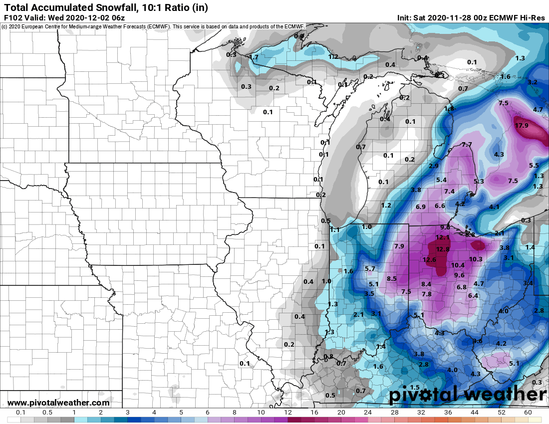


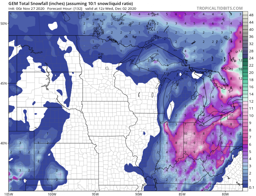
November 30-December 2 *Potential* Winter Storm
in Lakes/Ohio Valley
Posted
The problem is that temps are going to be above freezing until monday night so snow will have a real hard time accumulating until then.