
snowlover2
-
Posts
2,731 -
Joined
-
Last visited
Content Type
Profiles
Blogs
Forums
American Weather
Media Demo
Store
Gallery
Posts posted by snowlover2
-
-
18z GFS was a step in the right direction. Came back NW a bit and looked a little better organized.
-
 1
1
-
-
Better to be on the north side of the bullseye than in it or south at this point.
-
 1
1
-
-
9 minutes ago, Gino27 said:
Dropped again. This thing is a real headache lol
12z GFS still has it just suppressed.
-
6z GFS brought the storm back but was a little too east for most.
-
1
-
-
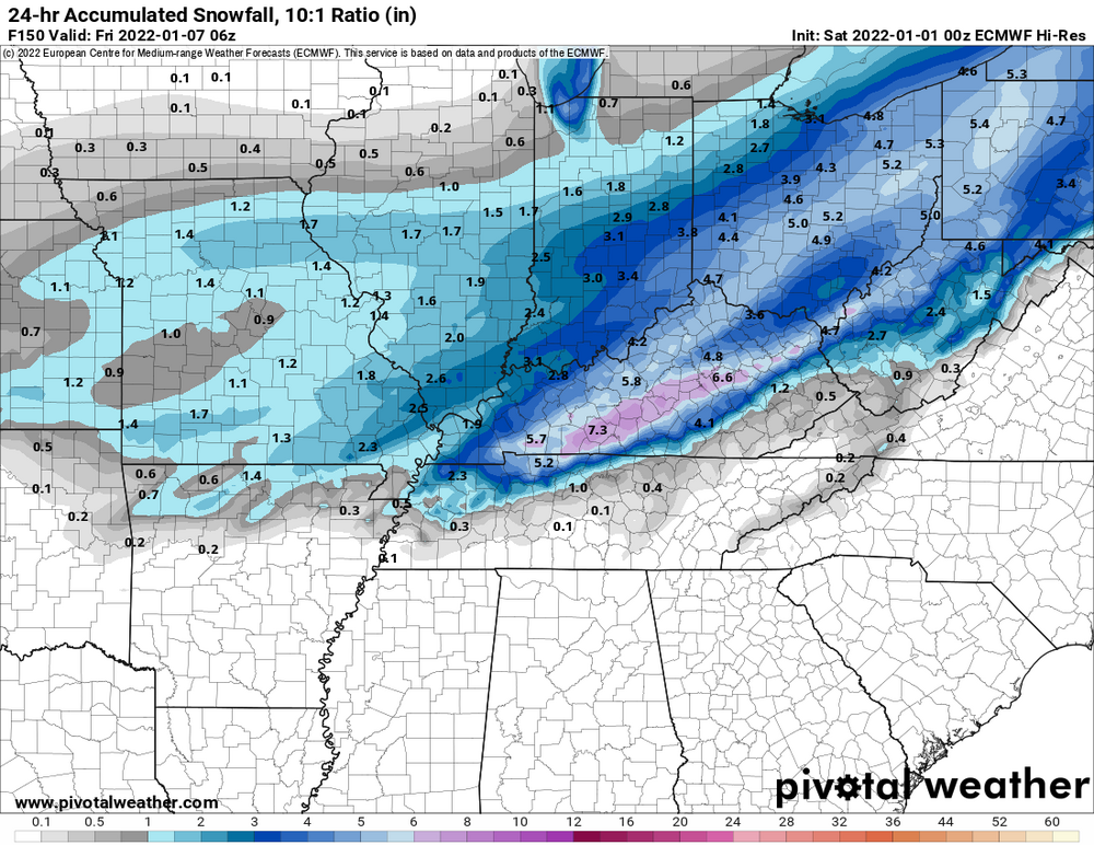
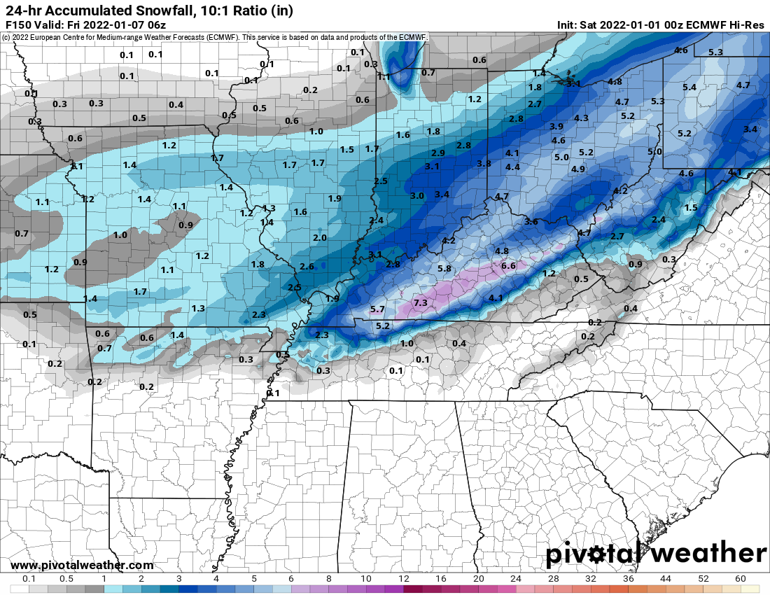
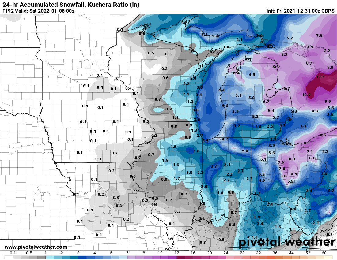
So basically the southern half of IN and most of Ohio is the storm in question. Knew kuchera would be higher.
.png.28e977fdbd39de50a5ce75aa3bdc5ffb.thumb.png.a742ff018b51cecd0a76a00380a7ab42.png)
-
2
-
-
Wish i had kuchera maps cause these totals would be higher.
-
Appears 0z Euro will still have it.
-
7 minutes ago, chuckster2012 said:
Well, nothing to look fwd to for another week, unless it comes back..
I've seen these disappear in mid range and come back in short range. Not close to being over.
-
1
-
-
0z GGEM pretty much lost it too.
-
5 minutes ago, Gino27 said:
Euro comes way NW and puts the mix line on the wrong side of I-71 for a lot of us. Not sure if it's an amped bias or if we're in for another rainer.
-
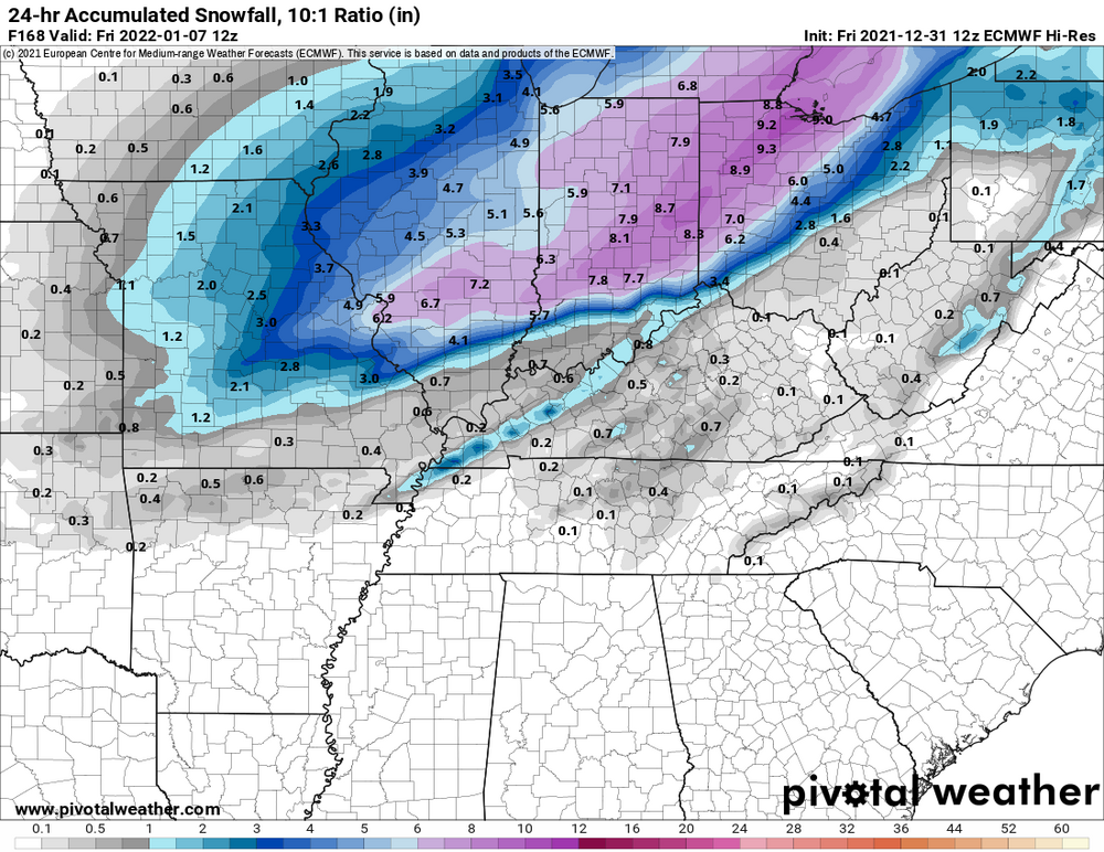
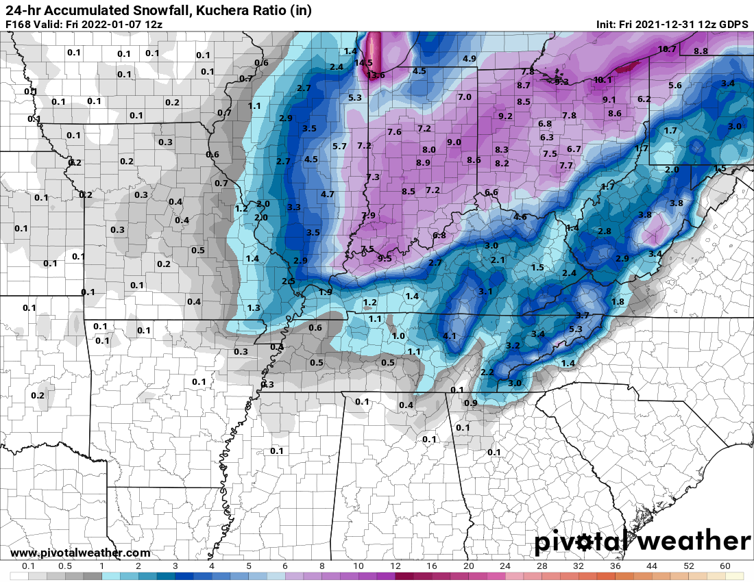
12z GGEM.

-
1
-
-
Back big time on the 12z GFS.

-
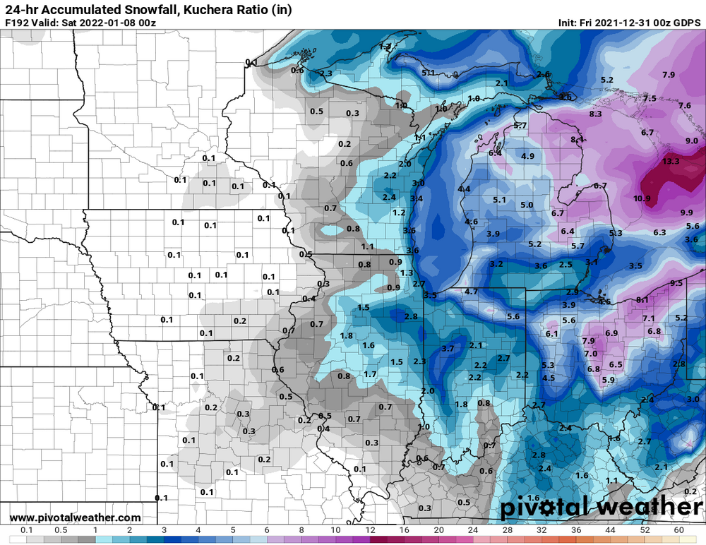
0z GGEM. Still not bad considering it tracked up to South Bend and then transferred east. Did go neg tilt eventually too.
-
1
-
-
Something i noticed on the 12z runs of the GGEM/Euro that GFS isn't doing at least yet is going neg tilt with the energy. That would obviously be important on how strong this storm gets.
-
39 minutes ago, jaf316 said:
Latest gfs lost the 1/7 storm, but today's euro now gives us a few inches on the 6th. I'd rather have the euro in my corner anyway...
Bet it will be back on the 0z.
-
1
-
-
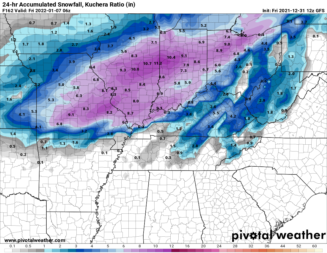
Quite a secondary on 0z GFS.
-
1
-
-
TE for Benton.
QuoteBULLETIN - EAS ACTIVATION REQUESTED Tornado Warning National Weather Service Paducah KY 945 PM CST Fri Dec 10 2021 ...TORNADO EMERGENCY FOR Benton... The National Weather Service in Paducah has issued a * Tornado Warning for... Southwestern Marshall County in western Kentucky... * Until 1000 PM CST. * At 944 PM CST, a confirmed large and destructive tornado was observed near Benton, moving northeast at 60 mph. TORNADO EMERGENCY for Benton. This is a PARTICULARLY DANGEROUS SITUATION. TAKE COVER NOW! HAZARD...Deadly tornado. SOURCE...Radar confirmed tornado. IMPACT...You are in a life-threatening situation. Flying debris may be deadly to those caught without shelter. Mobile homes will be destroyed. Considerable damage to homes, businesses, and vehicles is likely and complete destruction is possible. * This tornadic thunderstorm will remain over mainly rural areas of southwestern Marshall County. -
Quote
BULLETIN - EAS ACTIVATION REQUESTED Tornado Warning National Weather Service Paducah KY 940 PM CST Fri Dec 10 2021 The National Weather Service in Paducah has issued a * Tornado Warning for... Southeastern Livingston County in western Kentucky... Central Marshall County in western Kentucky... Northeastern Graves County in western Kentucky... Lyon County in western Kentucky... * Until 1030 PM CST. * At 939 PM CST, a confirmed large and extremely dangerous tornado was located near Benton, moving northeast at 60 mph. This is a PARTICULARLY DANGEROUS SITUATION. TAKE COVER NOW! HAZARD...Damaging tornado. SOURCE...Radar confirmed tornado. IMPACT...You are in a life-threatening situation. Flying debris may be deadly to those caught without shelter. Mobile homes will be destroyed. Considerable damage to homes, businesses, and vehicles is likely and complete destruction is possible. * The tornado will be near... Benton around 945 PM CST. Eddyville around 1010 PM CST. Other locations impacted by this tornadic thunderstorm include Kuttawa, Grand Rivers and Brewers. -
Just now, janetjanet998 said:
ULLETIN - EAS ACTIVATION REQUESTED
TORNADO WARNING
NATIONAL WEATHER SERVICE PADUCAH KY
926 PM CST FRI DEC 10 2021
..TORNADO EMERGENCY FOR MAYFIELD
THE NATIONAL WEATHER SERVICE IN PADUCAH HAS ISSUED A
* TORNADO WARNING FOR...
CENTRAL GRAVES COUNTY IN WESTERN KENTUCKY...
* UNTIL 1015 PM CST.
* AT 925 PM CST, A CONFIRMED LARGE AND DESTRUCTIVE TORNADO WAS
OBSERVED OVER MAYFIELD, MOVING NORTHEAST AT 60 MPH.
TORNADO EMERGENCY FOR MAYFIELD! THIS IS A PARTICULARLY DANGEROUS
SITUATION. TAKE COVER NOW!About time. Geez.
-
Quote
Severe Weather Statement National Weather Service Paducah KY 909 PM CST Fri Dec 10 2021 KYC075-105-110330- /O.CON.KPAH.TO.W.0034.000000T0000Z-211211T0330Z/ Fulton KY-Hickman KY- 909 PM CST Fri Dec 10 2021 ...A TORNADO WARNING REMAINS IN EFFECT UNTIL 930 PM CST FOR EAST CENTRAL FULTON AND SOUTHEASTERN HICKMAN COUNTIES... At 909 PM CST, a confirmed large and extremely dangerous tornado was located near Fulgham, or near Clinton, moving northeast at 55 mph. This is a PARTICULARLY DANGEROUS SITUATION. TAKE COVER NOW! HAZARD...Damaging tornado. SOURCE...Law enforcement confirmed tornado. IMPACT...You are in a life-threatening situation. Flying debris may be deadly to those caught without shelter. Mobile homes will be destroyed. Considerable damage to homes, businesses, and vehicles is likely and complete destruction is possible. This tornadic thunderstorm will remain over mainly rural areas of east central Fulton and southeastern Hickman Counties. This includes Interstate 69 in Kentucky between Mile Markers 5 and 8. PRECAUTIONARY/PREPAREDNESS ACTIONS... To repeat, a large, extremely dangerous and potentially deadly tornado is on the ground. To protect your life, TAKE COVER NOW! Move to a basement or an interior room on the lowest floor of a sturdy building. Avoid windows. If you are outdoors, in a mobile home, or in a vehicle, move to the closest substantial shelter and protect yourself from flying debris. Tornadoes are extremely difficult to see and confirm at night. Do not wait to see or hear the tornado. TAKE COVER NOW! && LAT...LON 3655 8900 3663 8900 3676 8882 3654 8882 TIME...MOT...LOC 0309Z 237DEG 46KT 3661 8894 TORNADO...OBSERVED TORNADO DAMAGE THREAT...CONSIDERABLE MAX HAIL SIZE...2.50 IN -
Heads up Mayfield KY!
QuoteBULLETIN - EAS ACTIVATION REQUESTED Tornado Warning National Weather Service Paducah KY 905 PM CST Fri Dec 10 2021 The National Weather Service in Paducah has issued a * Tornado Warning for... Marshall County in western Kentucky... Central Graves County in western Kentucky... * Until 945 PM CST. * At 904 PM CST, a confirmed large and extremely dangerous tornado was located near Cayce, or near Clinton, moving northeast at 55 mph. This is a PARTICULARLY DANGEROUS SITUATION. TAKE COVER NOW! HAZARD...Damaging tornado. SOURCE...Radar confirmed tornado. IMPACT...You are in a life-threatening situation. Flying debris may be deadly to those caught without shelter. Mobile homes will be destroyed. Considerable damage to homes, businesses, and vehicles is likely and complete destruction is possible. * The tornado will be near... Mayfield around 930 PM CST. Benton around 945 PM CST. Other locations impacted by this tornadic thunderstorm include Fancy Farm, Brewers, Symsonia, Wingo and Water Valley. This includes the following highways... Interstate 24 in Kentucky between Mile Markers 18 and 25. Interstate 69 in Kentucky between Mile Markers 9 and 51. -
Quote
Severe Weather Statement National Weather Service Paducah KY 901 PM CST Fri Dec 10 2021 KYC075-105-110330- /O.CON.KPAH.TO.W.0034.000000T0000Z-211211T0330Z/ Fulton KY-Hickman KY- 901 PM CST Fri Dec 10 2021 ...A TORNADO WARNING REMAINS IN EFFECT UNTIL 930 PM CST FOR SOUTHEASTERN FULTON AND SOUTHEASTERN HICKMAN COUNTIES... At 901 PM CST, a confirmed large and extremely dangerous tornado was located over Cayce, or 7 miles east of Hickman, moving northeast at 55 mph. This is a PARTICULARLY DANGEROUS SITUATION. TAKE COVER NOW! HAZARD...Damaging tornado. SOURCE...Radar confirmed tornado. IMPACT...You are in a life-threatening situation. Flying debris may be deadly to those caught without shelter. Mobile homes will be destroyed. Considerable damage to homes, businesses, and vehicles is likely and complete destruction is possible. The tornado will be near... Clinton around 910 PM CST. Fulgham around 915 PM CST. This includes Interstate 69 in Kentucky between Mile Markers 1 and 8. -
PDS warned cell heading toward Mayfield KY.
QuoteSevere Weather Statement National Weather Service Paducah KY 841 PM CST Fri Dec 10 2021 KYC075-105-MOC133-110330- /O.CON.KPAH.TO.W.0034.000000T0000Z-211211T0330Z/ Fulton KY-Hickman KY-Mississippi MO- 841 PM CST Fri Dec 10 2021 ...A TORNADO WARNING REMAINS IN EFFECT UNTIL 930 PM CST FOR FULTON... HICKMAN AND SOUTH CENTRAL MISSISSIPPI COUNTIES... At 841 PM CST, a confirmed large and extremely dangerous tornado was located near Clayton, or near Reelfoot Lake State Park, moving northeast at 55 mph. This is a PARTICULARLY DANGEROUS SITUATION. TAKE COVER NOW! HAZARD...Damaging tornado. SOURCE...Law enforcement confirmed tornado. IMPACT...You are in a life-threatening situation. Flying debris may be deadly to those caught without shelter. Mobile homes will be destroyed. Considerable damage to homes, businesses, and vehicles is likely and complete destruction is possible. The tornado will be near... Hickman around 855 PM CST. Cayce around 905 PM CST. Clinton around 910 PM CST. Fulgham around 915 PM CST. Other locations impacted by this tornadic thunderstorm include Boundurant. -
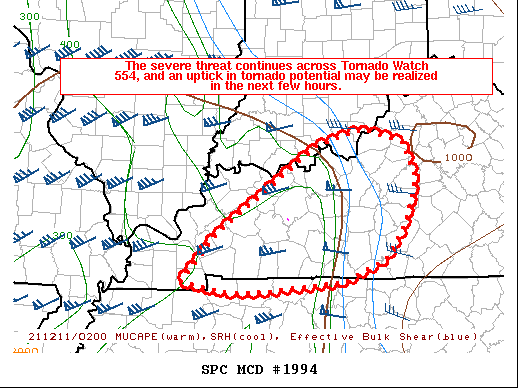
For the above disco.
-
1
-
.png.28e977fdbd39de50a5ce75aa3bdc5ffb.png.7ef569c75b57dcde4cd9fe04a3a72ae8.png)

“Let’s Talk Winter”
in Lakes/Ohio Valley
Posted
0z GGEM looking much better.