

snowlover2
-
Posts
2,731 -
Joined
-
Last visited
Content Type
Profiles
Blogs
Forums
American Weather
Media Demo
Store
Gallery
Posts posted by snowlover2
-
-
Quote
Severe Weather Statement National Weather Service Chicago/Romeoville 605 PM CDT Mon Aug 9 2021 ILC037-103-092345- /O.CON.KLOT.TO.W.0032.000000T0000Z-210809T2345Z/ Lee IL-De Kalb IL- 605 PM CDT Mon Aug 9 2021 ...A TORNADO WARNING REMAINS IN EFFECT UNTIL 645 PM CDT FOR EAST CENTRAL LEE AND SOUTHWESTERN DE KALB COUNTIES... At 604 PM CDT, a confirmed tornado was located over Paw Paw, or 7 miles southwest of Shabbona, moving east at 25 mph. HAZARD...Damaging tornado. SOURCE...Weather spotters and an off duty NWS forecaster confirmed a tornado. IMPACT...Flying debris will be dangerous to those caught without shelter. Mobile homes will be damaged or destroyed. Damage to roofs, windows, and vehicles will occur. Tree damage is likely. Locations impacted include... Paw Paw. -
New warning confirmed.
QuoteBULLETIN - EAS ACTIVATION REQUESTED Tornado Warning National Weather Service Chicago/Romeoville 532 PM CDT Mon Aug 9 2021 The National Weather Service in Chicago has issued a * Tornado Warning for... East central Ogle County in north central Illinois... Central De Kalb County in north central Illinois... * Until 615 PM CDT. * At 532 PM CDT, a confirmed tornado was located near Malta, or 7 miles northeast of Rochelle, moving east at 25 mph. HAZARD...Damaging tornado. SOURCE...Weather spotters confirmed tornado. IMPACT...Flying debris will be dangerous to those caught without shelter. Mobile homes will be damaged or destroyed. Damage to roofs, windows, and vehicles will occur. Tree damage is likely. * The tornado will be near... Malta around 545 PM CDT. Other locations in the path of this tornadic thunderstorm include DeKalb, Sycamore and Cortland. This includes... Northern Illinois University. Including the following interstate... I-88 between mile markers 87 and 95. -
4 minutes ago, SchaumburgStormer said:

Confirmed now.
QuoteSevere Weather Statement National Weather Service Chicago/Romeoville 528 PM CDT Mon Aug 9 2021 ILC037-089-092315- /O.CON.KLOT.TO.W.0029.000000T0000Z-210809T2315Z/ De Kalb IL-Kane IL- 528 PM CDT Mon Aug 9 2021 ...A TORNADO WARNING REMAINS IN EFFECT UNTIL 615 PM CDT FOR NORTHEASTERN DE KALB AND NORTHWESTERN KANE COUNTIES... At 528 PM CDT, a confirmed tornado was located near Hampshire, or 7 miles southeast of Genoa or due west of Burlington, moving east at 20 mph. An additional storm capable of producing a tornado was located 3 miles south of Genoa. HAZARD...Damaging tornado. SOURCE...Radar confirmed tornado. IMPACT...Flying debris will be dangerous to those caught without shelter. Mobile homes will be damaged or destroyed. Damage to roofs, windows, and vehicles will occur. Tree damage is likely. Locations impacted include... Lily Lake and Pingree Grove. -
2 confirmed tornadoes north of the Detroit area.
QuoteSevere Weather Statement National Weather Service Detroit/Pontiac MI 804 PM EDT Sat Jul 24 2021 MIC099-250030- /O.CON.KDTX.TO.W.0009.000000T0000Z-210725T0030Z/ Macomb MI- 804 PM EDT Sat Jul 24 2021 ...A TORNADO WARNING REMAINS IN EFFECT UNTIL 830 PM EDT FOR NORTHEASTERN MACOMB COUNTY... At 803 PM EDT, a confirmed tornado was located over Armada, or near Richmond, moving northeast at 20 mph. HAZARD...Damaging tornado. SOURCE...Radar confirmed tornado. IMPACT...Flying debris will be dangerous to those caught without shelter. Mobile homes will be damaged or destroyed. Damage to roofs, windows, and vehicles will occur. Tree damage is likely. This tornado will be near... Richmond around 815 PM EDTQuoteSevere Weather Statement National Weather Service Detroit/Pontiac MI 802 PM EDT Sat Jul 24 2021 MIC125-250045- /O.CON.KDTX.TO.W.0010.000000T0000Z-210725T0045Z/ Oakland MI- 802 PM EDT Sat Jul 24 2021 ...A TORNADO WARNING REMAINS IN EFFECT UNTIL 845 PM EDT FOR EAST CENTRAL OAKLAND COUNTY... At 802 PM EDT, a confirmed tornado was located near Clarkston, or 8 miles west of Pontiac, moving east at 15 mph. HAZARD...Damaging tornado. SOURCE...Radar confirmed tornado. IMPACT...Flying debris will be dangerous to those caught without shelter. Mobile homes will be damaged or destroyed. Damage to roofs, windows, and vehicles will occur. Tree damage is likely. This tornado will be near... Pontiac around 835 PM EDT. Troy and Birmingham around 845 PM EDT. Other locations impacted by this tornadic thunderstorm include Bloomfield Hills, Rochester Hills, Keego Harbor, Waterford, Bloomfield Township, White Lake, Clawson, Sylvan Lake, Auburn Hills and Lake Angelus. -
Currently a couple of tornado warnings in west central IL.
-
 1
1
-
-
Confirmed tornado in MI.
QuoteSevere Weather Statement National Weather Service Grand Rapids MI 448 PM EDT Sat Jun 26 2021 MIC067-262145- /O.CON.KGRR.TO.W.0003.000000T0000Z-210626T2145Z/ Ionia MI- 448 PM EDT Sat Jun 26 2021 ...A TORNADO WARNING REMAINS IN EFFECT UNTIL 545 PM EDT FOR EASTERN IONIA COUNTY... At 448 PM EDT, a confirmed tornado was located near Lake Odessa, or 9 miles west of Portland, moving northeast at 40 mph. HAZARD...Damaging tornado. SOURCE...Radar confirmed tornado. IMPACT...Flying debris will be dangerous to those caught without shelter. Mobile homes will be damaged or destroyed. Damage to roofs, windows, and vehicles will occur. Tree damage is likely. This tornado will be near... Ionia around 455 PM EDT. Portland around 500 PM EDT. Other locations impacted by this tornadic thunderstorm include Lyons, Hubbardston, Pewamo and Muir. -
Tornado Warning for South Bend IN.
QuoteBULLETIN - EAS ACTIVATION REQUESTED Tornado Warning National Weather Service Northern Indiana 409 PM EDT Sat Jun 26 2021 The National Weather Service in Northern Indiana has issued a * Tornado Warning for... Northeastern St. Joseph County in north central Indiana... * Until 445 PM EDT. * At 409 PM EDT, a severe thunderstorm capable of producing a tornado was located near Gulivoire Park, moving northeast at 35 mph. HAZARD...Tornado. SOURCE...Radar indicated rotation. IMPACT...Flying debris will be dangerous to those caught without shelter. Mobile homes will be damaged or destroyed. Damage to roofs, windows, and vehicles will occur. Tree damage is likely. * This dangerous storm will be near... South Bend around 415 PM EDT. Mishawaka, Georgetown and Roseland around 425 PM EDT. Other locations in the path of this tornadic thunderstorm include Osceola and Granger. This includes Interstate 80 in Indiana between mile markers 76 and 87. -
Quote
Severe Weather Statement National Weather Service Northern Indiana 1053 PM EDT Fri Jun 25 2021 INC049-260315- /O.CON.KIWX.TO.W.0011.000000T0000Z-210626T0315Z/ Fulton IN- 1053 PM EDT Fri Jun 25 2021 ...A TORNADO WARNING REMAINS IN EFFECT UNTIL 1115 PM EDT FOR NORTHWESTERN FULTON COUNTY... At 1052 PM EDT, a severe thunderstorm capable of producing a tornado was located 9 miles east of Winamac, moving northeast at 15 mph. HAZARD...Tornado. SOURCE...Radar indicated rotation. IMPACT...Flying debris will be dangerous to those caught without shelter. Mobile homes will be damaged or destroyed. Damage to roofs, windows, and vehicles will occur. Tree damage is likely. Locations impacted include... Kewanna, Leiters Ford, Bruce Lake Station and Lake Bruce. -
Confirmed tornado near Walton IN.
QuoteSevere Weather Statement National Weather Service Northern Indiana 934 PM EDT Fri Jun 25 2021 INC017-260145- /O.CON.KIWX.TO.W.0008.000000T0000Z-210626T0145Z/ Cass IN- 934 PM EDT Fri Jun 25 2021 ...A TORNADO WARNING REMAINS IN EFFECT UNTIL 945 PM EDT FOR SOUTHEASTERN CASS COUNTY... At 933 PM EDT, a confirmed tornado was located near Walton, or 8 miles southwest of Grissom Afb, moving northeast at 20 mph. HAZARD...Damaging tornado. SOURCE...Weather spotters confirmed tornado. IMPACT...Flying debris will be dangerous to those caught without shelter. Mobile homes will be damaged or destroyed. Damage to roofs, windows, and vehicles will occur. Tree damage is likely. Locations impacted include... Walton, Galveston and Deacon. -
New tornado warning NE IN/NW OH with wall cloud and funnel.
QuoteBULLETIN - EAS ACTIVATION REQUESTED Tornado Warning National Weather Service Northern Indiana 924 PM EDT Fri Jun 25 2021 The National Weather Service in Northern Indiana has issued a * Tornado Warning for... East central De Kalb County in northeastern Indiana... Northwestern Defiance County in northwestern Ohio... Southwestern Williams County in northwestern Ohio... * Until 1000 PM EDT. * At 924 PM EDT, a severe thunderstorm capable of producing a tornado was located over Butler, moving northeast at 25 mph. Spotters are reporting a wall cloud as a funnel cloud. HAZARD...Tornado. SOURCE...Weather spotters reported funnel cloud. IMPACT...Flying debris will be dangerous to those caught without shelter. Mobile homes will be damaged or destroyed. Damage to roofs, windows, and vehicles will occur. Tree damage is likely. * This dangerous storm will be near... Edgerton around 935 PM EDT. -
New confirmed warning.
QuoteBULLETIN - EAS ACTIVATION REQUESTED Tornado Warning National Weather Service Indianapolis IN 924 PM EDT Fri Jun 25 2021 The National Weather Service in Indianapolis has issued a * Tornado Warning for... East central Carroll County in north central Indiana... Northwestern Howard County in central Indiana... * Until 945 PM EDT. * At 923 PM EDT, a confirmed tornado was located 8 miles southwest of Walton, or 12 miles south of Logansport, moving northeast at 20 mph. HAZARD...Damaging tornado. SOURCE...Weather spotters confirmed tornado at 9:19 PM EDT in eastern Carroll County. IMPACT...Flying debris will be dangerous to those caught without shelter. Mobile homes will be damaged or destroyed. Damage to roofs, windows, and vehicles will occur. Tree damage is likely. * This tornadic thunderstorm will remain over mainly rural areas of east central Carroll and northwestern Howard Counties. -
Confirmed near Danforth now.
QuoteSevere Weather Statement National Weather Service Chicago/Romeoville 813 PM CDT Fri Jun 25 2021 ILC075-260145- /O.CON.KLOT.TO.W.0009.000000T0000Z-210626T0145Z/ Iroquois IL- 813 PM CDT Fri Jun 25 2021 ...A TORNADO WARNING REMAINS IN EFFECT UNTIL 845 PM CDT FOR NORTHWESTERN IROQUOIS COUNTY... At 812 PM CDT, a confirmed tornado was located near Dnaforth, moving east at 15 mph. HAZARD...Damaging tornado and quarter size hail. SOURCE...Weather spotters confirmed tornado. IMPACT...Flying debris will be dangerous to those caught without shelter. Mobile homes will be damaged or destroyed. Damage to roofs, windows, and vehicles will occur. Tree damage is likely. Locations impacted include... Danforth. -
Confirmed west of Kokomo again.
QuoteSevere Weather Statement National Weather Service Indianapolis IN 910 PM EDT Fri Jun 25 2021 INC015-067-260130- /O.CON.KIND.TO.W.0006.000000T0000Z-210626T0130Z/ Carroll IN-Howard IN- 910 PM EDT Fri Jun 25 2021 ...A TORNADO WARNING REMAINS IN EFFECT UNTIL 930 PM EDT FOR SOUTHEASTERN CARROLL AND NORTHWESTERN HOWARD COUNTIES... At 909 PM EDT, a confirmed tornado was located 12 miles southwest of Walton, or 15 miles west of Kokomo, moving east at 20 mph. HAZARD...Damaging tornado. SOURCE...Weather spotters confirmed tornado. IMPACT...Flying debris will be dangerous to those caught without shelter. Mobile homes will be damaged or destroyed. Damage to roofs, windows, and vehicles will occur. Tree damage is likely. This tornadic thunderstorm will remain over mainly rural areas of southeastern Carroll and northwestern Howard Counties. -
Confirmed tornado west of Kokomo IN.
QuoteSevere Weather Statement National Weather Service Indianapolis IN 835 PM EDT Fri Jun 25 2021 INC015-260100- /O.CON.KIND.TO.W.0005.000000T0000Z-210626T0100Z/ Carroll IN- 835 PM EDT Fri Jun 25 2021 ...A TORNADO WARNING REMAINS IN EFFECT UNTIL 900 PM EDT FOR SOUTHERN CARROLL COUNTY... At 834 PM EDT, a confirmed tornado was located 7 miles southeast of Delphi, or 15 miles north of Frankfort, moving northeast at 25 mph. HAZARD...Damaging tornado. SOURCE...Emergency management confirmed tornado. IMPACT...Flying debris will be dangerous to those caught without shelter. Mobile homes will be damaged or destroyed. Damage to roofs, windows, and vehicles will occur. Tree damage is likely. This tornado will be near... Flora around 845 PM EDT. Other locations in the path of this tornadic thunderstorm include Burlington.-
1
-
-
Tornado warning north of Decatur IL.
QuoteBULLETIN - EAS ACTIVATION REQUESTED Tornado Warning National Weather Service Lincoln IL 558 PM CDT Fri Jun 25 2021 The National Weather Service in Lincoln has issued a * Tornado Warning for... West central Piatt County in central Illinois... Southeastern De Witt County in central Illinois... Northeastern Macon County in central Illinois... * Until 630 PM CDT. * At 558 PM CDT, a severe thunderstorm capable of producing a tornado was located over Argenta, or 11 miles southeast of Clinton, moving northeast at 15 mph. HAZARD...Tornado. SOURCE...Radar indicated rotation. IMPACT...Flying debris will be dangerous to those caught without shelter. Mobile homes will be damaged or destroyed. Damage to roofs, windows, and vehicles will occur. Tree damage is likely. * Locations impacted include... Weldon. This includes Interstate 72 between mile markers 153 and 160. -
Quote
PUBLIC INFORMATION STATEMENT
NATIONAL WEATHER SERVICE WILMINGTON OH
1020 PM EDT SAT JUN 19 2021

...EF2 TORNADO CONFIRMED NEAR FORT RECOVERY IN MERCER COUNTY OHIO
ON JUNE 18, 2021...

LOCATION...NEAR FORT RECOVERY IN MERCER COUNTY OHIO
DATE...JUNE 18, 2021
ESTIMATED STARTING TIME...4:12 PM EDT
ESTIMATED ENDING TIME...4:25 PM EDT
MAXIMUM EF- SCALE RATING...EF2
ESTIMATED MAXIMUM WIND SPEED...115 MPH
MAXIMUM PATH WIDTH...200 YARDS
PATH LENGTH...5.7 MILES
BEGINNING LAT/LON...40.4327N/ 84.7917W
ENDING LAT/LON...40.3815N/ 84.7092W
* FATALITIES...0
* INJURIES...0

...SUMMARY...
THE NATIONAL WEATHER SERVICE, WITH THE ASSISTANCE AND SUPPORT
FROM THE MERCER COUNTY EMERGENCY MANAGEMENT AGENCY AND THE FORT
RECOVERY FIRE DEPARTMENT, CONFIRMS AN EF2 TORNADO NEAR FORT
RECOVERY OHIO ON FRIDAY AFTERNOON JUNE 18, 2021.

THE FIRST SIGN OF TORNADIC DAMAGE WAS OBSERVED JUST EAST OF THE
INDIANA/OHIO STATE LINE. TREES WERE SNAPPED ALONG PARK ROAD,
INDICATIVE OF EF0 TORNADO DAMAGE. THE TORNADO THEN MOVED
SOUTHEAST, AND MAY HAVE BRIEFLY LIFTED, BEFORE TOUCHING BACK DOWN
AND LEAVING A NOTICEABLE SWIRL IN A WHEAT FIELD BETWEEN ST JOE
ROAD AND WABASH ROAD. THE TORNADO INTENSIFIED AS IT MOVED ACROSS
WABASH ROAD, IMPACTING THE FORT RECOVERY LUMBER YARD. MULTIPLE
ROOFS WERE COMPLETELY LIFTED OFF SEVERAL OUTBUILDINGS.
ADDITIONALLY, A COLLAPSED CINDER BLOCK WALL WAS OBSERVED AT THE
FORT RECOVERY LUMBER YARD. THIS WAS CONSISTENT WITH EF1 DAMAGE.
THE TORNADO THEN CONTINUED MOVING SOUTHEAST THROUGH WOODED AREAS
BETWEEN WABASH ROAD AND FORT RECOVERY-MINSTER ROAD. HARDWOOD TREE
DAMAGE WAS NOTED IN THE WOODED AREAS.

AFTER CROSSING FORT RECOVERY-MINSTER ROAD, PARTIAL REMOVAL OF AN
OUTBUILDING ROOF WAS NOTED ALONG WITH TREE DAMAGE. MORE
SIGNIFICANT DAMAGE THEN BECAME APPARENT AS THE TORNADO CONTINUED
SOUTHEAST IMPACTING THE BURRVILLE ROAD/HART ROAD AREA. MULTIPLE
HOMES ALONG BURRVILLE ROAD SUSTAINED SUBSTANTIAL ROOF DAMAGE
INCLUDING TOTAL REMOVAL OF OVER HALF THE ROOF OF A SINGLE FAMILY
HOME. THE SURVEY TEAM ALSO NOTED COMPLETELY DESTROYED
OUTBUILDINGS, THE REMOVAL OF ATTACHED GARAGES, SUBSTANTIAL TREE
DAMAGE, AND PROJECTILES EMBEDDED WITHIN AN EXTERIOR WALL.
SEVERAL WOOD POWER POLES ALONG BURRVILLE ROAD WERE ALSO
COMPLETELY BROKEN. DEBRIS FROM BURRVILLE ROAD WAS THROWN
APPROXIMATELY A HALF MILE TOWARD WOURMS ROAD. IN ADDITION, THE
TORNADO PRODUCED DAMAGE ALONG WOURMS ROAD, WHICH INCLUDED MORE
BROKEN WOOD POWER POLES. THE WOODED AREA ALONG WOURMS ROAD ALSO
EXHIBITED THE MOST SIGNIFICANT TREE DAMAGE, WHERE NUMEROUS
HARDWOOD TREES WERE SNAPPED OR KNOCKED OVER. DAMAGE ALONG BURRVILLE
ROAD AND WOURMS ROAD WAS CONSISTENT WITH LOW END EF2 DAMAGE, WITH
MAXIMUM WINDS OF AROUND 115 MPH.

THE TORNADO SEEMED TO RAPIDLY WEAKEN AS IT MOVED SOUTHEAST TO FOX
ROAD AND MEIRING ROAD. THE ONLY DAMAGE SEEN WAS MINOR DAMAGE TO
AN OUTBUILDING AND PARTIAL REMOVAL OF THE TOP OF A SILO. NO
ADDITIONAL DAMAGE WAS OBSERVED TO THE SOUTHEAST OF THIS AREA.

THE NATIONAL WEATHER SERVICE IN WILMINGTON THANKS THE MERCER COUNTY OHIO
EMERGENCY MANAGEMENT AGENCY AND THE FORT RECOVERY FIRE DEPARTMENT FOR THE
ASSISTANCE WITH THIS STORM DAMAGE SURVEY.

EF SCALE: THE ENHANCED FUJITA SCALE CLASSIFIES TORNADOES INTO THE
FOLLOWING CATEGORIES:

EF0...WEAK......65 TO 85 MPH
EF1...WEAK......86 TO 110 MPH
EF2...STRONG....111 TO 135 MPH
EF3...STRONG....136 TO 165 MPH
EF4...VIOLENT...166 TO 200 MPH
EF5...VIOLENT...>200 MPH

* THE INFORMATION IN THIS STATEMENT IS PRELIMINARY AND SUBJECT TO
CHANGE PENDING FINAL REVIEW OF THE EVENT AND PUBLICATION IN NWS
STORM DATA.

$$
BPP/CAMPBELL
-
Got quite a bit of pea to marble sized hail out of it.
-
-
Confirmed tornado in eastern IL.
QuoteBULLETIN - EAS ACTIVATION REQUESTED Tornado Warning National Weather Service Lincoln IL 740 PM CDT Wed Apr 28 2021 The National Weather Service in Lincoln has issued a * Tornado Warning for... South central Douglas County in east central Illinois... * Until 800 PM CDT. * At 740 PM CDT, a confirmed tornado was located over Arcola, or 10 miles south of Tuscola, moving northeast at 25 mph. HAZARD...Tornado. SOURCE...Weather spotters confirmed tornado. IMPACT...Expect damage to mobile homes, roofs, and vehicles. * The tornado will be near... Arcola around 745 PM CDT. This includes Interstate 57 between mile markers 203 and 208.
-
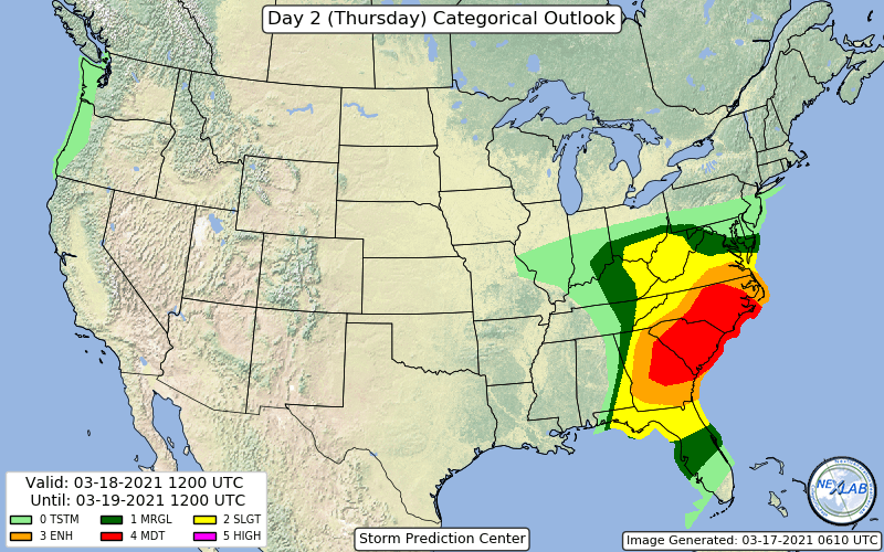
Day 2 moderate also.
-
 4
4
-
-
4 hours ago, Hoosier said:
Slight change 00z to 12z

Wouldn't this be for a different thread?
-
 1
1
-
-
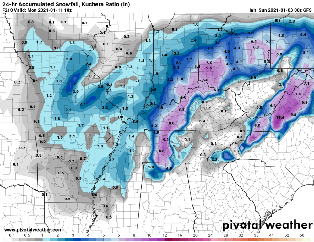
0z GFS teasing IN/OH on the 10th and 11th.
-
1
-
-
Happy New Year!
-
3
-
-
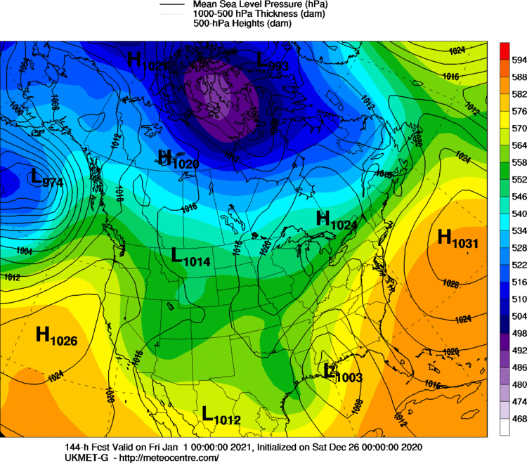
End of 0z Ukie.


August 9-12, 2021 Severe Threats
in Lakes/Ohio Valley
Posted