

snowlover2
-
Posts
2,731 -
Joined
-
Last visited
Content Type
Profiles
Blogs
Forums
American Weather
Media Demo
Store
Gallery
Posts posted by snowlover2
-
-
Appears to be back to PDS warned but with possible 2.5" hail now.
QuoteBULLETIN - EAS ACTIVATION REQUESTED Tornado Warning National Weather Service Memphis TN 828 PM CST Fri Dec 10 2021 The National Weather Service in Memphis has issued a * Tornado Warning for... Northwestern Obion County in western Tennessee... Northeastern Lake County in western Tennessee... * Until 915 PM CST. * At 827 PM CST, a confirmed large and extremely dangerous tornado was located near Tiptonville, or near Reelfoot Lake State Park, moving northeast at 50 mph. This is a PARTICULARLY DANGEROUS SITUATION. TAKE COVER NOW! HAZARD...Damaging tornado. SOURCE...Radar confirmed tornado. IMPACT...You are in a life-threatening situation. Flying debris may be deadly to those caught without shelter. Mobile homes will be destroyed. Considerable damage to homes, businesses, and vehicles is likely and complete destruction is possible. * The tornado will be near... Clayton around 850 PM CST. Union City around 855 PM CST. Other locations impacted by this tornadic thunderstorm include Woodland Mills, Roneys Store, Spout Springs, Walnut Log, Old Fremont, Grays Camp, New Markham, Samburg, Fremont and Crystal. PRECAUTIONARY/PREPAREDNESS ACTIONS... Tornadoes are extremely difficult to see and confirm at night. Do not wait to see or hear the tornado. TAKE COVER NOW! && LAT...LON 3650 8896 3633 8933 3647 8944 3650 8942 3651 8930 TIME...MOT...LOC 0227Z 235DEG 45KT 3634 8953 TORNADO...OBSERVED TORNADO DAMAGE THREAT...CONSIDERABLE MAX HAIL SIZE...2.50 IN -
New tornado emergency!
QuoteSevere Weather Statement National Weather Service Memphis TN 818 PM CST Fri Dec 10 2021 MOC155-TNC045-095-131-110245- /O.CON.KMEG.TO.W.0063.000000T0000Z-211211T0245Z/ Pemiscot MO-Dyer TN-Obion TN-Lake TN- 818 PM CST Fri Dec 10 2021 ...TORNADO EMERGENCY FOR Tiptonville Tennessee... ...A TORNADO WARNING REMAINS IN EFFECT UNTIL 845 PM CST FOR EASTERN PEMISCOT...NORTHWESTERN DYER...WESTERN OBION AND LAKE COUNTIES... At 817 PM CST, a confirmed large and destructive tornado was located near Caruthersville, moving northeast at 55 mph. TORNADO EMERGENCY for Tiptonville Tennessee. This is a PARTICULARLY DANGEROUS SITUATION. TAKE COVER NOW! HAZARD...Deadly tornado. SOURCE...Radar confirmed tornado. IMPACT...You are in a life-threatening situation. Flying debris may be deadly to those caught without shelter. Mobile homes will be destroyed. Considerable damage to homes, businesses, and vehicles is likely and complete destruction is possible. The tornado will be near... Ridgely around 825 PM CST. Tiptonville around 830 PM CST. Reelfoot Lake State Park around 835 PM CST. Clayton around 845 PM CST. Other locations impacted by this tornadic thunderstorm include Ayers, Cat Corner, Wynnburg, Glass, Wright, Cronanville, Hathaway, Roneys Store, Elbridge and Sunkist Beach. PRECAUTIONARY/PREPAREDNESS ACTIONS... To repeat, a large, extremely dangerous, and potentially deadly tornado is on the ground. To protect your life, TAKE COVER NOW! Move to an interior room on the lowest floor of a sturdy building. Avoid windows. If in a mobile home, a vehicle or outdoors, move to the closest substantial shelter and protect yourself from flying debris. Tornadoes are extremely difficult to see and confirm at night. Do not wait to see or hear the tornado. TAKE COVER NOW! && LAT...LON 3651 8928 3630 8909 3607 8967 3629 8983 3640 8967 3641 8962 3640 8959 3634 8954 3634 8953 3638 8951 3642 8955 3646 8952 3648 8952 3649 8954 3650 8953 3650 8949 3647 8949 3646 8947 3650 8942 TIME...MOT...LOC 0217Z 235DEG 46KT 3627 8964 TORNADO...OBSERVED TORNADO DAMAGE THREAT...CATASTROPHIC MAX HAIL SIZE...2.00 IN -
Quote
Severe Weather Statement National Weather Service Memphis TN 808 PM CST Fri Dec 10 2021 MOC155-TNC045-095-110215- /O.CON.KMEG.TO.W.0062.000000T0000Z-211211T0215Z/ Pemiscot MO-Dyer TN-Lake TN- 808 PM CST Fri Dec 10 2021 ...TORNADO EMERGENCY FOR Caruthersville and Hayti in Missouri... ...A TORNADO WARNING REMAINS IN EFFECT UNTIL 815 PM CST FOR CENTRAL PEMISCOT...NORTHWESTERN DYER AND SOUTHWESTERN LAKE COUNTIES... At 807 PM CST, a confirmed large and destructive tornado was located over Hayti Heights, or over Hayti, moving northeast at 55 mph. TORNADO EMERGENCY for Caruthersville and Hayti in Missouri. This is a PARTICULARLY DANGEROUS SITUATION. TAKE COVER NOW! HAZARD...Deadly tornado. SOURCE...Radar confirmed tornado. IMPACT...You are in a life-threatening situation. Flying debris may be deadly to those caught without shelter. Mobile homes will be destroyed. Considerable damage to homes, businesses, and vehicles is likely and complete destruction is possible. This tornadic thunderstorm will remain over mainly rural areas of central Pemiscot, northwestern Dyer and southwestern Lake Counties, including the following locations... Ayers, Tennemo, Hathaway, Boothspoint, Pascola, Owl Hoot, Braggadocio, Covington, Shade and Bakerville. PRECAUTIONARY/PREPAREDNESS ACTIONS... To repeat, a large, extremely dangerous, and potentially deadly tornado is on the ground. To protect your life, TAKE COVER NOW! Move to an interior room on the lowest floor of a sturdy building. Avoid windows. If in a mobile home, a vehicle or outdoors, move to the closest substantial shelter and protect yourself from flying debris. Tornadoes are extremely difficult to see and confirm at night. Do not wait to see or hear the tornado. TAKE COVER NOW! && LAT...LON 3611 8950 3602 8985 3623 8996 3638 8963 TIME...MOT...LOC 0207Z 238DEG 49KT 3620 8976 TORNADO...OBSERVED TORNADO DAMAGE THREAT...CATASTROPHIC MAX HAIL SIZE...2.00 IN -
New tornado emergency!
QuoteBULLETIN - EAS ACTIVATION REQUESTED Tornado Warning National Weather Service Memphis TN 804 PM CST Fri Dec 10 2021 ...TORNADO EMERGENCY FOR Caruthersville and Hayti in Missouri... The National Weather Service in Memphis has issued a * Tornado Warning for... Eastern Pemiscot County in southeastern Missouri... Northwestern Dyer County in western Tennessee... Western Obion County in western Tennessee... Lake County in western Tennessee... * Until 845 PM CST. * At 802 PM CST, a confirmed large and destructive tornado was observed near Deering, or near Steele, moving northeast at 60 mph. TORNADO EMERGENCY for Caruthersville and Hayti in Missouri. This is a PARTICULARLY DANGEROUS SITUATION. TAKE COVER NOW! HAZARD...Deadly tornado. SOURCE...Radar confirmed tornado. IMPACT...You are in a life-threatening situation. Flying debris may be deadly to those caught without shelter. Mobile homes will be destroyed. Considerable damage to homes, businesses, and vehicles is likely and complete destruction is possible. * The tornado will be near... Caruthersville around 810 PM CST. Ridgely and Cottonwood Grove around 820 PM CST. Reelfoot Lake State Park and Tiptonville around 830 PM CST. Clayton around 840 PM CST. Other locations impacted by this tornadic thunderstorm include Ayers, Cat Corner, Wynnburg, Glass, Wright, Cronanville, Hathaway, Roneys Store, Elbridge and Sunkist Beach. -
Tornado emergency finally!
QuoteSevere Weather Statement National Weather Service Memphis TN 753 PM CST Fri Dec 10 2021 ARC093-MOC069-155-TNC045-095-110215- /O.CON.KMEG.TO.W.0062.000000T0000Z-211211T0215Z/ Mississippi AR-Pemiscot MO-Dunklin MO-Dyer TN-Lake TN- 753 PM CST Fri Dec 10 2021 ...TORNADO EMERGENCY FOR Southern Dunklin and Pemiscot counties including Denton and Steele... ...A TORNADO WARNING REMAINS IN EFFECT UNTIL 815 PM CST FOR NORTH CENTRAL MISSISSIPPI...PEMISCOT...SOUTHEASTERN DUNKLIN...NORTHWESTERN DYER AND SOUTHWESTERN LAKE COUNTIES... At 751 PM CST, a confirmed large and destructive tornado was located near Hornersville, or 7 miles north of Gosnell, moving northeast at 50 mph. TORNADO EMERGENCY for Southern Dunklin and Pemiscot counties including Denton and Steele. This is a PARTICULARLY DANGEROUS SITUATION. TAKE COVER NOW! HAZARD...Deadly tornado. SOURCE...Radar confirmed tornado. IMPACT...You are in a life-threatening situation. Flying debris may be deadly to those caught without shelter. Mobile homes will be destroyed. Considerable damage to homes, businesses, and vehicles is likely and complete destruction is possible. The tornado will be near... Cooter around 800 PM CST. Steele and Deering around 805 PM CST. Caruthersville, Hayti and Hayti Heights around 815 PM CST. Other locations impacted by this tornadic thunderstorm include Lenox, Ayers, Calumet, Hathaway, Woodland Corner, Pascola, Holland, Tennemo, Number Nine and Boothspoint. -
Quote
URGENT - IMMEDIATE BROADCAST REQUESTED
   Tornado Watch Number 557
   NWS Storm Prediction Center Norman OK
   745 PM CST Fri Dec 10 2021

   The NWS Storm Prediction Center has issued a

   * Tornado Watch for portions of
     Central and eastern Illinois
     Western to southern Indiana

   * Effective this Friday night and Saturday morning from 745 PM
     until 200 AM CST.

   * Primary threats include...
     A few tornadoes likely with a couple intense tornadoes possible
     Scattered damaging winds likely with isolated significant gusts
       to 80 mph possible

   SUMMARY...A fast-moving linear cluster with embedded supercells will
   spread east from western Illinois into Indiana tonight.

   The tornado watch area is approximately along and 60 statute miles
   east and west of a line from 45 miles northeast of Peoria IL to 40
   miles south southwest of Bloomington IN. For a complete depiction of
   the watch see the associated watch outline update (WOUS64 KWNS
   WOU7).

   PRECAUTIONARY/PREPAREDNESS ACTIONS...

   REMEMBER...A Tornado Watch means conditions are favorable for
   tornadoes and severe thunderstorms in and close to the watch
   area. Persons in these areas should be on the lookout for
   threatening weather conditions and listen for later statements
   and possible warnings.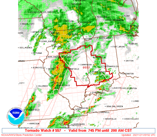
-
Quote
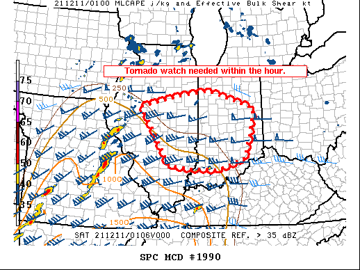
 Mesoscale Discussion 1990
   NWS Storm Prediction Center Norman OK
   0718 PM CST Fri Dec 10 2021

   Areas affected...Central and Eastern Illinois and western and
   central Indiana.

   Concerning...Severe potential...Watch likely

   Valid 110118Z - 110245Z

   Probability of Watch Issuance...95 percent

   SUMMARY...A tornado watch will be needed within the next hour across
   portions of Illinois and Indiana.

   DISCUSSION...A broken line of supercells has developed across
   eastern Missouri and will move into central Illinois and eventually
   Indiana during the overnight hours. Dewpoints are only in the mid to
   upper 50s across Indiana and eastern Illinois at this time which
   yields limited instability in the region. However, the strong
   low-level jet will continue to advect low-level moisture northward
   with the 00Z HRRR showing low 60s dewpoints advecting northward
   ahead of the storms as they move into Indiana. This will yield
   MLCAPE between 500 and 1000 J/kg. This instability combined with an
   extremely favorable wind field (90 knots of 0-6 km shear and over
   600 m2/s2 0 to 1 km SRH per ILX VWP) should continue a significant
   severe weather threat through the overnight hours with primary
   threats of damaging winds and tornadoes (a few of which may be
   strong). A tornado watch will be needed within the hour to cover
   this threat.

   ..Bentley/Grams.. 12/11/2021
-
Quote
BULLETIN - EAS ACTIVATION REQUESTED Tornado Warning National Weather Service St Louis MO 735 PM CST Fri Dec 10 2021 The National Weather Service in St Louis has issued a * Tornado Warning for... Southeastern Calhoun County in southwestern Illinois... Southwestern Jersey County in southwestern Illinois... St. Charles County in east central Missouri... Northwestern Jefferson County in east central Missouri... Southeastern Lincoln County in east central Missouri... Eastern Franklin County in east central Missouri... St. Louis County in east central Missouri... Southeastern Warren County in east central Missouri... * Until 815 PM CST. * At 734 PM CST, a tornado producing storm was located over Augusta, moving east at 50 mph. HAZARD...Damaging tornado. SOURCE...Radar confirmed tornado. IMPACT...Flying debris will be dangerous to those caught without shelter. Mobile homes will be damaged or destroyed. Damage to roofs, windows, and vehicles will occur. Tree damage is likely. * This tornadic storm will be near... Defiance around 745 PM CST. Wildwood, Spirit of St. Louis Airport and Weldon Spring Heights around 750 PM CST. Other locations in the path of this tornadic thunderstorm include St. Peters, Ballwin, Ellisville, Weldon Spring, Cottleville, Clarkson Valley, Winchester, Chesterfield, Manchester, Town and Country, Harvester, Kirkwood, Maryland Heights, Ladue, Des Peres, Frontenac, Warson Woods, Crystal Lake Park, Huntleigh, Westwood, Country Life Acres, University City, Creve Coeur, Overland, Clayton, St. Ann, Bridgeton, Richmond Heights, Brentwood, Maplewood, Olivette, Florissant, Hazelwood, Berkeley, Bel-Ridge, Kinloch, Pagedale and Bel-Nor. This also includes Babler Memorial State Park, Route 66 State Park, Castlewood State Park, First Missouri State Capitol Historic Site, Robertsville State Park, and Pere Marquette State Park. This includes the following highways... Interstate 44 in Missouri between exits 239 and 277. Interstate 70 in Missouri between exits 200 and 231. -
New PDS warning.
QuoteBULLETIN - EAS ACTIVATION REQUESTED Tornado Warning National Weather Service Memphis TN 728 PM CST Fri Dec 10 2021 The National Weather Service in Memphis has issued a * Tornado Warning for... Northeastern Mississippi County in eastern Arkansas... Pemiscot County in southeastern Missouri... Southeastern Dunklin County in southeastern Missouri... Western Dyer County in western Tennessee... Northeastern Lauderdale County in western Tennessee... Southwestern Lake County in western Tennessee... * Until 815 PM CST. * At 728 PM CST, a confirmed large and extremely dangerous tornado was located over Leachville, moving northeast at 50 mph. This is a PARTICULARLY DANGEROUS SITUATION. TAKE COVER NOW! HAZARD...Damaging tornado. SOURCE...Weather spotters confirmed tornado. IMPACT...You are in a life-threatening situation. Flying debris may be deadly to those caught without shelter. Mobile homes will be destroyed. Considerable damage to homes, businesses, and vehicles is likely and complete destruction is possible. * The tornado will be near... Hornersville around 745 PM CST. Gosnell around 750 PM CST. Blytheville around 755 PM CST. Steele, Cooter and Deering around 805 PM CST. Caruthersville, Hayti, Hayti Heights and Heloise around 815 PM CST. Other locations impacted by this tornadic thunderstorm include Calumet, Dearman, Pascola, Poplar Grove, Lens Ford, Tennemo, Stark City, Boothspoint, Armorel and Big Boy Junction. PRECAUTIONARY/PREPAREDNESS ACTIONS... Tornadoes are extremely difficult to see and confirm at night. Do not wait to see or hear the tornado. TAKE COVER NOW! && LAT...LON 3638 8963 3590 8940 3584 9002 3613 9018 TIME...MOT...LOC 0128Z 244DEG 42KT 3592 9029 TORNADO...OBSERVED TORNADO DAMAGE THREAT...CONSIDERABLE MAX HAIL SIZE...2.00 IN -
1 minute ago, cheese007 said:
Debris ball by Monette per TX Storm Chasers twitter feed
QuoteSevere Weather Statement National Weather Service Memphis TN 725 PM CST Fri Dec 10 2021 ARC031-055-093-MOC069-110145- /O.CON.KMEG.TO.W.0061.000000T0000Z-211211T0145Z/ Greene AR-Craighead AR-Mississippi AR-Dunklin MO- 725 PM CST Fri Dec 10 2021 ...A TORNADO WARNING REMAINS IN EFFECT UNTIL 745 PM CST FOR SOUTHEASTERN GREENE...NORTHEASTERN CRAIGHEAD...NORTHWESTERN MISSISSIPPI AND SOUTHWESTERN DUNKLIN COUNTIES... At 724 PM CST, a confirmed large and extremely dangerous tornado was located over Monette, moving northeast at 45 mph. This is a PARTICULARLY DANGEROUS SITUATION. TAKE COVER NOW! HAZARD...Damaging tornado. SOURCE...Weather spotters confirmed tornado. IMPACT...You are in a life-threatening situation. Flying debris may be deadly to those caught without shelter. Mobile homes will be destroyed. Considerable damage to homes, businesses, and vehicles is likely and complete destruction is possible. The tornado will be near... Leachville around 730 PM CST. Manila, Cardwell and Arbyrd around 735 PM CST. Hornersville around 745 PM CST. Gosnell around 750 PM CST. Other locations impacted by this tornadic thunderstorm include Jolliff Store, Delfore, Dearman, Lennie, Vail, Carmi, Whisp, Buckeye, Lester and Arkmo. PRECAUTIONARY/PREPAREDNESS ACTIONS... Tornadoes are extremely difficult to see and confirm at night. Do not wait to see or hear the tornado. TAKE COVER NOW! && LAT...LON 3573 9029 3597 9056 3618 9009 3578 8989 TIME...MOT...LOC 0124Z 245DEG 40KT 3590 9034 TORNADO...OBSERVED TORNADO DAMAGE THREAT...CONSIDERABLE MAX HAIL SIZE...2.00 IN -
Still a PDS warning.
QuoteSevere Weather Statement National Weather Service Memphis TN 717 PM CST Fri Dec 10 2021 ARC031-055-093-110130- /O.CON.KMEG.TO.W.0060.000000T0000Z-211211T0130Z/ Greene AR-Craighead AR-Mississippi AR- 717 PM CST Fri Dec 10 2021 ...A TORNADO WARNING REMAINS IN EFFECT UNTIL 730 PM CST FOR SOUTH CENTRAL GREENE...EASTERN CRAIGHEAD AND WEST CENTRAL MISSISSIPPI COUNTIES... At 717 PM CST, a confirmed large and extremely dangerous tornado was located over Lake City, moving northeast at 45 mph. This is a PARTICULARLY DANGEROUS SITUATION. TAKE COVER NOW! HAZARD...Damaging tornado. SOURCE...Weather spotters confirmed tornado. IMPACT...You are in a life-threatening situation. Flying debris may be deadly to those caught without shelter. Mobile homes will be destroyed. Considerable damage to homes, businesses, and vehicles is likely and complete destruction is possible. The tornado will be near... Caraway around 720 PM CST. Monette around 725 PM CST. Other locations impacted by this tornadic thunderstorm include Poplar Ridge, Needham, Milligan Ridge, Lunsford, Vail, Elm Grove, Degelow, Macey, Schug and Sandy. -
New PDS warning.
QuoteBULLETIN - EAS ACTIVATION REQUESTED Tornado Warning National Weather Service Memphis TN 706 PM CST Fri Dec 10 2021 The National Weather Service in Memphis has issued a * Tornado Warning for... Southeastern Greene County in eastern Arkansas... Northeastern Craighead County in eastern Arkansas... Northwestern Mississippi County in eastern Arkansas... Southwestern Dunklin County in southeastern Missouri... * Until 745 PM CST. * At 706 PM CST, a confirmed large and extremely dangerous tornado was located near Bay, moving northeast at 45 mph. This is a PARTICULARLY DANGEROUS SITUATION. TAKE COVER NOW! HAZARD...Damaging tornado. SOURCE...Weather spotters confirmed tornado. IMPACT...You are in a life-threatening situation. Flying debris may be deadly to those caught without shelter. Mobile homes will be destroyed. Considerable damage to homes, businesses, and vehicles is likely and complete destruction is possible. * The tornado will be near... Monette and Caraway around 725 PM CST. Leachville around 735 PM CST. Manila around 740 PM CST. Gosnell, Hornersville and Dell around 745 PM CST. Other locations impacted by this tornadic thunderstorm include Jolliff Store, Delfore, Dearman, Lennie, Vail, Carmi, Whisp, Buckeye, Lester and Arkmo. -
Jonesboro PDS warned now!
QuoteSevere Weather Statement National Weather Service Memphis TN 656 PM CST Fri Dec 10 2021 ARC031-055-093-111-110130- /O.CON.KMEG.TO.W.0060.000000T0000Z-211211T0130Z/ Greene AR-Craighead AR-Poinsett AR-Mississippi AR- 656 PM CST Fri Dec 10 2021 ...A TORNADO WARNING REMAINS IN EFFECT UNTIL 730 PM CST FOR SOUTH CENTRAL GREENE...CRAIGHEAD...NORTH CENTRAL POINSETT AND WESTERN MISSISSIPPI COUNTIES... At 655 PM CST, a confirmed large and extremely dangerous tornado was located near Greenfield, or near Jonesboro, moving northeast at 60 mph. This is a PARTICULARLY DANGEROUS SITUATION. TAKE COVER NOW! HAZARD...Damaging tornado. SOURCE...Weather spotters confirmed tornado. IMPACT...You are in a life-threatening situation. Flying debris may be deadly to those caught without shelter. Mobile homes will be destroyed. Considerable damage to homes, businesses, and vehicles is likely and complete destruction is possible. The tornado will be near... Trumann and Bay around 705 PM CST. Lake City and Brookland around 710 PM CST. Monette and Caraway around 720 PM CST. Other locations impacted by this tornadic thunderstorm include Hergett, Apt, Vail, Valley View, Macey, Schug, Gum Point, Farrville, Lester and Mandalay. -
4 minutes ago, CheeselandSkies said:
Finally!
Confirmed now.
QuoteSevere Weather Statement National Weather Service Memphis TN 643 PM CST Fri Dec 10 2021 ARC031-055-093-111-110130- /O.CON.KMEG.TO.W.0060.000000T0000Z-211211T0130Z/ Greene AR-Craighead AR-Poinsett AR-Mississippi AR- 643 PM CST Fri Dec 10 2021 ...A TORNADO WARNING REMAINS IN EFFECT UNTIL 730 PM CST FOR SOUTH CENTRAL GREENE...CRAIGHEAD...NORTHERN POINSETT AND WESTERN MISSISSIPPI COUNTIES... At 642 PM CST, a confirmed tornado was located near Weiner, or 11 miles northwest of Harrisburg, moving northeast at 55 mph. HAZARD...Damaging tornado, quarter size hail, and 60 mph wind gusts. SOURCE...Weather spotters confirmed tornado. IMPACT...Flying debris will be dangerous to those caught without shelter. Mobile homes will be damaged or destroyed. Damage to roofs, windows, and vehicles will occur. Tree damage is likely. This tornado will be near... Greenfield around 650 PM CST. Jonesboro and Brookland around 705 PM CST. Lake City around 710 PM CST. Monette around 720 PM CST. Other locations impacted by this tornadic thunderstorm include Hergett, Apt, Vail, Valley View, Macey, Schug, Gum Point, Farrville, Lester and Maple Grove. -
4 minutes ago, CheeselandSkies said:
I can't understand why AR warning hasn't been reissued/expanded NE to include Jonesboro.
There ya go.
QuoteBULLETIN - EAS ACTIVATION REQUESTED Tornado Warning National Weather Service Memphis TN 639 PM CST Fri Dec 10 2021 The National Weather Service in Memphis has issued a * Tornado Warning for... South central Greene County in eastern Arkansas... Craighead County in eastern Arkansas... Northern Poinsett County in eastern Arkansas... Western Mississippi County in eastern Arkansas... * Until 730 PM CST. * At 638 PM CST, a severe thunderstorm producing a tornado was located over Weiner, or 13 miles northwest of Harrisburg, moving northeast at 55 mph. HAZARD...Tornado and quarter size hail. SOURCE...Radar indicated rotation. IMPACT...Flying debris will be dangerous to those caught without shelter. Mobile homes will be damaged or destroyed. Damage to roofs, windows, and vehicles will occur. Tree damage is likely. * This dangerous storm will be near... Greenfield around 650 PM CST. Jonesboro around 705 PM CST. Lake City and Brookland around 710 PM CST. Monette around 720 PM CST. Other locations impacted by this tornadic thunderstorm include Hergett, Apt, Vail, Valley View, Macey, Schug, Gum Point, Farrville, Lester and Maple Grove. -
Moderate risk just added to IL/IN/KY/MO area.
-
Tornado warnings in NE Ohio currently with one confirmed west of Akron.
-
ILN has confirmed and rated 5 tornadoes from last night including an EF2 near South Salem.
QuotePublic Information Statement National Weather Service Wilmington OH 1010 PM EDT Sat Oct 16 2021 ...TORNADO CONFIRMED IN WESTERN ROSS COUNTY OHIO ON 10/16/2021... Start Location...South Salem, Ohio End Location...0.5 miles SE of South Salem, Ohio Date...October 16, 2021 Estimated Starting Time...1:28 AM EDT Estimated Ending Time...1:31 AM EDT Maximum EF-Scale Rating...EF2 Estimated Maximum Wind Speed...115 mph Maximum Path Width...100 yards Path Length...0.7 miles Beginning Lat/Lon...39.3375N / 83.3086W Ending Lat/Lon...39.3381N / 83.2926W * Fatalities...0 * Injuries...0 ...Summary... The tornado initially started causing damage to trees east of South Salem Cemetery and within Sunseth Park. The highest intensity occurred shortly after touch down with two structures destroyed along Stewart Street. One structure, which was bolted to a concrete foundation, was lofted onto Stewart Street. The other structure had nearly all of the exterior walls collapsed. The roof was lofted and pieces were found littered along the tornado track through the town. Snapped power poles also occurred along Stewart Street. The tornado then moved southeast over Main Street with significant tree and minor structure damage observed. The tornado continued to cause tree damage and minor structure damage along Lower Twin Road before exiting South Salem to the east. The final tree damage observed was along a creek south of Lower Twin Road where multiple trees were snapped and uprooted. The National Weather Service in Wilmington would like to thank the Ross County Ohio Emergency Management Agency and South Salem Fire Department for their assistance with all three Ross County tornadoes. EF Scale: The Enhanced Fujita Scale classifies tornadoes into the following categories: EF0...Weak......65 to 85 mph EF1...Weak......86 to 110 mph EF2...Strong....111 to 135 mph EF3...Strong....136 to 165 mph EF4...Violent...166 to 200 mph EF5...Violent...>200 mph * The information in this statement is preliminary and subject to change pending final review of the event and publication in NWS Storm Data.
-
 1
1
-
-
New tornado warning out. Could eventually get close to Hoosier but likely staying just south.
QuoteBULLETIN - EAS ACTIVATION REQUESTED Tornado Warning National Weather Service Chicago/Romeoville 1006 PM CDT Mon Aug 9 2021 The National Weather Service in Chicago has issued a * Tornado Warning for... East central Will County in northeastern Illinois... * Until 1100 PM CDT. * At 1006 PM CDT, a severe thunderstorm capable of producing a tornado was located near Manhattan, or near Peotone, moving east at 25 mph. HAZARD...Tornado. SOURCE...Radar indicated rotation. IMPACT...Flying debris will be dangerous to those caught without shelter. Mobile homes will be damaged or destroyed. Damage to roofs, windows, and vehicles will occur. Tree damage is likely. * Locations impacted include... Monee, University Park, Park Forest, Crete, Beecher and Steger. This includes... Governors State University. Including the following interstate... I-57 between mile markers 328 and 337. -
Tornado warning south of Joliet.
-
New confirmed tornado in IL.
QuoteBULLETIN - EAS ACTIVATION REQUESTED Tornado Warning National Weather Service Quad Cities IA/IL 730 PM CDT Mon Aug 9 2021 The National Weather Service in the Quad Cities has issued a * Tornado Warning for... Central Bureau County in north central Illinois... * Until 815 PM CDT. * At 730 PM CDT, a confirmed tornado was located over Wyanet, or near Princeton, moving east at 20 mph. HAZARD...Damaging tornado. SOURCE...Public confirmed tornado. IMPACT...Flying debris will be dangerous to those caught without shelter. Mobile homes will be damaged or destroyed. Damage to roofs, windows, and vehicles will occur. Tree damage is likely. * The tornado will be near... Princeton and Tiskilwa around 740 PM CDT. Other locations in the path of this tornadic thunderstorm include DePue and Bureau Junction. -
Still PDS and now rain wrapped.
QuoteSevere Weather Statement National Weather Service Chicago/Romeoville 635 PM CDT Mon Aug 9 2021 ILC089-100000- /O.CON.KLOT.TO.W.0033.000000T0000Z-210810T0000Z/ Kane IL- 635 PM CDT Mon Aug 9 2021 ...A TORNADO WARNING REMAINS IN EFFECT UNTIL 700 PM CDT FOR WEST CENTRAL KANE COUNTY... At 634 PM CDT, a confirmed large and extremely dangerous tornado was located 3 miles northeast of Maple Park, or 7 miles west of Campton Hills, moving east at 25 mph. Weather spotters report the tornado has become rain wrapped and will be difficult if not impossible to see! This is a PARTICULARLY DANGEROUS SITUATION. TAKE COVER NOW! HAZARD...Damaging tornado. SOURCE...Weather spotters confirmed tornado. IMPACT...You are in a life-threatening situation. Flying debris may be deadly to those caught without shelter. Mobile homes will be destroyed. Considerable damage to homes, businesses, and vehicles is likely and complete destruction is possible. Locations impacted include... Campton Hills, Elburn, Maple Park, Lily Lake and Virgil. -
PDS warning!
QuoteSevere Weather Statement National Weather Service Chicago/Romeoville 632 PM CDT Mon Aug 9 2021 ILC089-100000- /O.CON.KLOT.TO.W.0033.000000T0000Z-210810T0000Z/ Kane IL- 632 PM CDT Mon Aug 9 2021 ...A TORNADO WARNING REMAINS IN EFFECT UNTIL 700 PM CDT FOR WEST CENTRAL KANE COUNTY... At 631 PM CDT, a confirmed large and extremely dangerous tornado was located 3 miles northeast of Maple Park, or 7 miles west of Campton Hills, moving east at 25 mph. This is a PARTICULARLY DANGEROUS SITUATION. TAKE COVER NOW! HAZARD...Damaging tornado. SOURCE...Weather spotters confirmed tornado. IMPACT...You are in a life-threatening situation. Flying debris may be deadly to those caught without shelter. Mobile homes will be destroyed. Considerable damage to homes, businesses, and vehicles is likely and complete destruction is possible. Locations impacted include... Campton Hills, Elburn, Maple Park, Lily Lake and Virgil. -
5 minutes ago, SchaumburgStormer said:
Funnel SE of sycamore. Y
Confirmed now.
QuoteSevere Weather Statement National Weather Service Chicago/Romeoville 618 PM CDT Mon Aug 9 2021 ILC037-089-100000- /O.CON.KLOT.TO.W.0033.000000T0000Z-210810T0000Z/ De Kalb IL-Kane IL- 618 PM CDT Mon Aug 9 2021 ...A TORNADO WARNING REMAINS IN EFFECT UNTIL 700 PM CDT FOR EAST CENTRAL DE KALB AND WEST CENTRAL KANE COUNTIES... At 617 PM CDT, a confirmed tornado was located near Sycamore, moving east at 25 mph. HAZARD...Damaging tornado. SOURCE...Weather spotters confirmed tornado. IMPACT...Flying debris will be dangerous to those caught without shelter. Mobile homes will be damaged or destroyed. Damage to roofs, windows, and vehicles will occur. Tree damage is likely. Locations impacted include... Lily Lake, Campton Hills and Elburn.
Dec. 10-11 Severe Weather
in Lakes/Ohio Valley
Posted