

JoshM
-
Posts
3,398 -
Joined
-
Last visited
Content Type
Profiles
Blogs
Forums
American Weather
Media Demo
Store
Gallery
Everything posted by JoshM
-
You brought all the mojo!!!
-
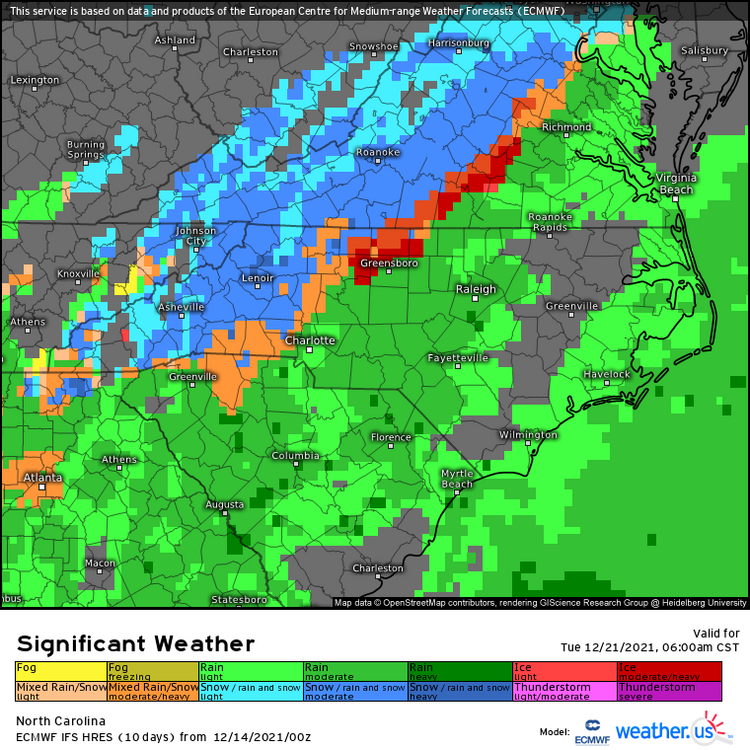
Charlotte is the "winner" this time with 1.68 inches of ZR
-
Yes, the "making it's own cold" would come from the ULL on the backend.
-
I haven't seen a situation with a low thru TN like that and a CAD holding on that strong. Still a long ways to go
-
Ya, I'm good on that. If the track keeps moving west I don't see how the CAD would hold for that much ZR.
-
Nearly 2 inches of ZR for GSP and 1.5 for CLT
-
6z GFS is a mess
-
Funnily enough, the heart of the CAD area is colder compared to 12z
-
Ya... It's lights out for the CAD areas, literally and/or figuratively
-
Canadian following suit
-
Well… guess I’ll come hang out over here.
-
Awaiting the 0z runs…
-
Indeed, looking good
-
We're already getting the weenies and noobs showing up. Everyone buckle up, it's gonna get rough
-
0z GFS brings us out of fantasy range with some coastal love next weekend.
-
more fantasy land eye candy, looks like a 2002 redux
-
When the big one comes you will be starting the thread! No ifs ands or buts.
-
I wasn't laughing at it. Climate change or not, this is a shit pattern. It wouldn't produce 50 years ago and it won't produce today. +3.5 degrees means nothing when it's 75 degrees. Just means there's a little extra lighter fluid on the dumpster fire.
-
-
Euro tries to bring a little love in on the 21st
-
Usually happens when there's a pattern change coming.
-
Other than Tuesday, it's way above normal, even into fantasy range
-
Anyone looking at the 18z GFS might need to put some welding goggles on first.
-
Start the thread... Just trend a little colder


