weatherwiz
-
Posts
81,150 -
Joined
-
Last visited
Content Type
Profiles
Blogs
Forums
American Weather
Media Demo
Store
Gallery
Everything posted by weatherwiz
-

July 2025 Obs/Disco ... possible historic month for heat
weatherwiz replied to Typhoon Tip's topic in New England
If this is the direction we're going to head then there is going to be some serious issues somewhere for sure. Want to wait another day or so before really getting concerned and crazy but this is impressive for summer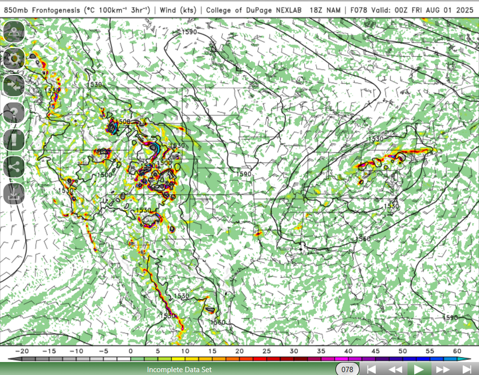
-
July 2025 Obs/Disco ... possible historic month for heat
weatherwiz replied to Typhoon Tip's topic in New England
It certainly seems like it. Looking at the NAM though you could probably also argue that 925/850 low could be overstated...even maybe on euro a bit but the weathermodel graphics are awful. I could see this going either way right now but it def has to be watched. -
July 2025 Obs/Disco ... possible historic month for heat
weatherwiz replied to Typhoon Tip's topic in New England
That is one hell of a thermal gradient though for the warm season across the region. That would be some hefty lift across the region along the warm front with some decent elevated CAPE. Would have to wonder though if convection across the mid-Atlantic robs any moisture...convection could be robust there. This is interesting and intriguing for sure. -
July 2025 Obs/Disco ... possible historic month for heat
weatherwiz replied to Typhoon Tip's topic in New England
The front though does look like it would become parallel to the upper-level flow. There are some signals for a significant rainfall event but some of these signals could be overstated too. Have to see where we stand in the next 1-2 days -
July 2025 Obs/Disco ... possible historic month for heat
weatherwiz replied to Typhoon Tip's topic in New England
The NAM/Euro may have a bit of convective feedback going on -
July 2025 Obs/Disco ... possible historic month for heat
weatherwiz replied to Typhoon Tip's topic in New England
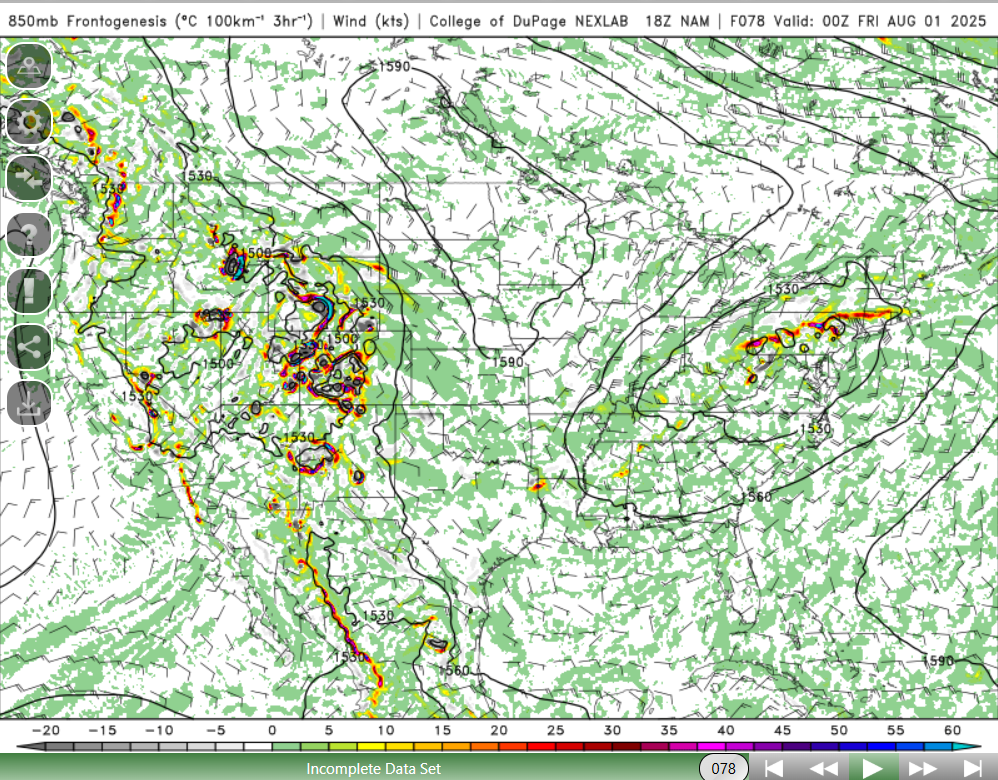
Oh man look at this from the 12z NAM for DSM this evening. Those CAPE numbers are ridiculous. 1450 Hail CAPE...WOOOOOOWWWWWW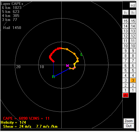
-
July 2025 Obs/Disco ... possible historic month for heat
weatherwiz replied to Typhoon Tip's topic in New England
we should bake, especially with the westerly sfc flow and should have ample sun -
July 2025 Obs/Disco ... possible historic month for heat
weatherwiz replied to Typhoon Tip's topic in New England
CAPE is great but means nothing without a robust enough trigger! Unfortunately, the largest CAPE days generally occur when there is a lack of forcing/trigger. CAPE values that high aren't actually uncommon in those parts but it gains more attention when you have a forcing mechanism. -
July 2025 Obs/Disco ... possible historic month for heat
weatherwiz replied to Typhoon Tip's topic in New England
Thursday though could feature potential for a few tornadoes across southern CT/Long Island/RI/Cape Cod -
July 2025 Obs/Disco ... possible historic month for heat
weatherwiz replied to Typhoon Tip's topic in New England
That NAM has a narrow corridor of 5000-6000 J of MLCape with DCAPE values ~1500+ J....that's absurd. There's going to be some significant wind damage -
July 2025 Obs/Disco ... possible historic month for heat
weatherwiz replied to Typhoon Tip's topic in New England
We may get nada in SNE Wednesday...storms for NNE and then southwest of us. After that weak front passes through tomorrow I'm not even sure we truly warm sector on Wednesday. You may have a weak warm front lifting north but the true or secondary warm front never even gets into the region. -
July 2025 Obs/Disco ... possible historic month for heat
weatherwiz replied to Typhoon Tip's topic in New England
Thanks! Always had wondered that, this makes a lot of sense. -
July 2025 Obs/Disco ... possible historic month for heat
weatherwiz replied to Typhoon Tip's topic in New England
Right now biggest question is how much instability will materialize. I would expect at least scattered thunderstorms to develop early-to-mid afternoon and progress southeast quickly through the late afternoon. Shear is enough to warrant the potential for thunderstorms to organize into a line. Shear is also enough to yield a low probability for a tornado along the warm front (which will be up around that area). I'd say 3-7 PM is the time frame for storms...that can probably even be narrowed down a bit more tomorrow too. -
July 2025 Obs/Disco ... possible historic month for heat
weatherwiz replied to Typhoon Tip's topic in New England
that feature is very evident. Assessing real time observations is a lot of fun and something I'm trying to do much more frequently and want to do as we move through the winter. Sometimes its so easy to get caught up and looking at models and complaining about the lack of consistency between models or figuring out which model has the better handle and forgetting there is a great way to answer these questions...compare initialization and real-time observations over the next 6-12 hours to guidance and that will help answer these questions. A few weeks ago I remember watching water vapor for quite some time. The weather pattern featured a trough digging into the west with the jet stream poleward into the Inter-mountain West. So you had a dry punch entering the desert Southwest and as that air ascended over the Inter-mountains cloud and convection forming. And with the ridge across the south you had the jet axis becoming more zonal into the central states so as that air descended the Rockies the convection/clouds dissipated...it was great/cool watching science work in real time. -
July 2025 Obs/Disco ... possible historic month for heat
weatherwiz replied to Typhoon Tip's topic in New England
Do you think the "launch pad" aspect of temperatures overrated? I mean wouldn't the degree of mixing and the lapse rate hold the most weight? -
July 2025 Obs/Disco ... possible historic month for heat
weatherwiz replied to Typhoon Tip's topic in New England
I would watch for tonight to perhaps end up a bit farther south than what guidance has...probably following along the southern edge of where the SPC has the enhanced so I would watch this closely. I know there is only the marginal right now for tomorrow but could be another big night. May not see another moderate but wouldn't be surprised if an enhanced risk was eventually thrown out there once the details become clearer. -
July 2025 Obs/Disco ... possible historic month for heat
weatherwiz replied to Typhoon Tip's topic in New England
the SPC does mention derecho...nice -
July 2025 Obs/Disco ... possible historic month for heat
weatherwiz replied to Typhoon Tip's topic in New England
Is that some sort of very weak backdoor that rolls through tomorrow evening? Or maybe just a weakening front that probably lifts north a bit Wednesday as a warm front. -
July 2025 Obs/Disco ... possible historic month for heat
weatherwiz replied to Typhoon Tip's topic in New England
I'd have very low confidence in the end of the week. How all this convective potential evolves from the upper-Midwest/Great Lakes/Ohio Valley is going to play a significant factor in how this evolves for us. -
July 2025 Obs/Disco ... possible historic month for heat
weatherwiz replied to Typhoon Tip's topic in New England
MAV 97 for BOS tomorrow, MET 92, and NBM 95. A quick look yields that BOS certainly has a shot for 97 tomorrow...would not be shocked at a 98 -
July 2025 Obs/Disco ... possible historic month for heat
weatherwiz replied to Typhoon Tip's topic in New England
Can't wait to we start getting sunshine and crank up the sweatiness. -
July 2025 Obs/Disco ... possible historic month for heat
weatherwiz replied to Typhoon Tip's topic in New England
Could be a solid concentrated swath of wind damage though with distance criteria like 400 or 450 miles it may fall short of the definition for a derecho. -
July 2025 Obs/Disco ... possible historic month for heat
weatherwiz replied to Typhoon Tip's topic in New England
For a second I thought this was smoke this morning then realized its fog. -
July 2025 Obs/Disco ... possible historic month for heat
weatherwiz replied to Typhoon Tip's topic in New England
Tropics are dead for a while -
July 2025 Obs/Disco ... possible historic month for heat
weatherwiz replied to Typhoon Tip's topic in New England
Oh of course though last year was the first time in my life I didn’t stay up to watch 10:00 or 10:30 games…well I did the first few. But there were also several games I packed it in early. Nothing will ever beat a few years ago, no matter how disappointing blowing the 3-1 series lead was. That regular season was incredible. Every game was enjoyable