

weatherwiz
-
Posts
79,817 -
Joined
-
Last visited
Content Type
Profiles
Blogs
Forums
American Weather
Media Demo
Store
Gallery
Everything posted by weatherwiz
-
This would probably help with the idea of "too many tools in the box". There are so many models and data to digest, who really has time to do all of that? If the energy and focus can be spent on a few models to improve assimilation and initialization that would go a substantial way in improving forecast accuracy and confidence.
-
Was shocked to see that mentioned. Isn't that a "newer product anyways"? I forgot when HREF became operational but I feel like it was at least in the last 10 years?
-
Interesting. Assuming this could be a big positive in more resources would be available for the RRFS instead of running all these various short-term mesos.
-
mid 80's may be tough but we will be warming the llvls through the day with a northwesterly flow so probably have to tack on 2-3F to the 2m progs.
-
Timing blows a bit tomorrow but western areas could see some storms during the early evening. Probably see marginal expanded east some with an upgrade to a slight risk in there
-
Sure could be! I was thinking about you when I was looking at that earlier haha. I knew you would provide some in depth analysis on this. Good call Kevin yesterday
-
Actually I wonder if Berkshire County could get some strong storms late Sat afternoon or early evening
-
Tuesday could be a fun day...start of NHL free agency and maybe some strong storms!
-
Hoping Friday evening is dry (should be). May do a fire and round 1 of the NHL draft outside. Will be a perfect evening for a fire though I’d prefer the 100/73.
-
jet exhaust
-
on an E win at 14 mph?
-
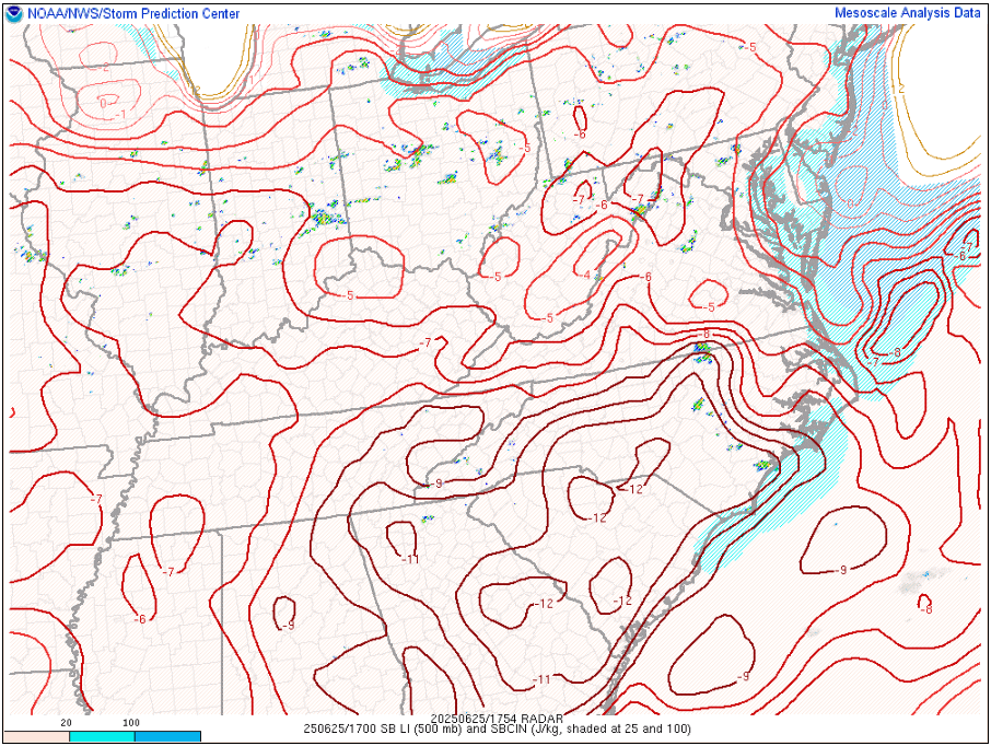
LIs of -12C in the Carolinas into Georgia!!!!
-
hate seeing these depressing posts
-
It looks like the euro wants to retreat the stationary front through as a warm front with cold front siding later. I wish the euro was right but don't really see any means for that occurring. Would like to see some sort of strengthening sfc low passing to our north and west
-
yeah Saturday blows
-
They're going to recharge and come back with a vengeance and then there will be no escape.
-
still some differences on how far southwest front pushes and where it stalls.
-
Just saw EWR only got down to 85 last night...that's wild
-
yeah I was noticing that. Looks kind of anafront-ish like?
-
There are certain setups in which the 3km can get too happy with precipitation development
-
Not too sold on the rain depiction there. Think it is overdone
-
Well outside of influences of any fronts/precipitation on temperatures, the overall regime after these next few days is going to be above average and quite humid. Obviously not going to come close to what we just saw. Should be plenty of shower/thunder chances too.
-
guhhhh tell Crapon to stop making up numbers
-
yeah wonky for sure...seems like its displaying HI but maybe using a different calculation method
-
That's actually tier 1. I went onto my Radrscope and see that too.


