

OceanStWx
-
Posts
20,131 -
Joined
-
Last visited
Content Type
Profiles
Blogs
Forums
American Weather
Media Demo
Store
Gallery
Posts posted by OceanStWx
-
-
13 minutes ago, CT Rain said:
The RRFS is on weatherbell for sure. It does OK from what I can see.
My bigger question is how it does in the cold season - cold air damming, mesoscale banding, etc.
Not great, Bob.
That's going to be my biggest loss with the NAM.
-
10 minutes ago, weatherwiz said:
This would probably help with the idea of "too many tools in the box". There are so many models and data to digest, who really has time to do all of that? If the energy and focus can be spent on a few models to improve assimilation and initialization that would go a substantial way in improving forecast accuracy and confidence.
Clearing out some of the computing resources also potentially leads to more model runs. There are ways to get more data out of this.
-
 2
2
-
-
43 minutes ago, FXWX said:
Would not want to lose the HREF...
10 minutes ago, weatherwiz said:Was shocked to see that mentioned. Isn't that a "newer product anyways"? I forgot when HREF became operational but I feel like it was at least in the last 10 years?
It was like 2017ish.
It was a bit of a Frankenstein "model". We really wanted some sort of probabilistic convective scale guidance, but it takes a lot of computing to run a large CAM ensemble. So somebody smarter than me decided to take what we already had running (ARW, HRRR, NSSL, etc) and turn them into a poor man's ensemble along with the 12 hour old versions of the same models.
Pros: it provides some probability-like forecast parameters, it has a range of models/convective cores that can provide insight when biases are known.
Cons: it is not a true ensemble, as you would prefer one core and the entire range of possibilities for that.
-
 2
2
-
-
2 hours ago, weatherwiz said:
Interesting. Assuming this could be a big positive in more resources would be available for the RRFS instead of running all these various short-term mesos.
That's the theory of the case anyway. Instead of pouring resources into multiple models, we can focus all our energy on making the RRFS really good.
Of course the FV3 core was really not great for convection and had to be scrapped. So now we're starting over with MPAS for a core.
In an ideal world you would have the GFS/GEFS for longer range, RRFS/REFS for the inside 60 hours, and WoFS for storm scale, event driven cases.
-
2
-
-
On 6/25/2025 at 2:54 PM, dendrite said:
@OceanStWx Can you get early access to the raw 1-min data?
I could have if I had been at work.
 On 6/25/2025 at 3:01 PM, dendrite said:
I swear I remember it being 5 min unless it was changed.
As far as I know it is still 5 min. Temps are taken every min, and the high temp is the highest 5 min average. The only 2 min check I know on temps is to ensure they aren't more than 10 deg different on the 1 min obs (if they are it is set to missing).
Winds are 2 min, so maybe that's the confusion.
-
1
-
-
I'm excited to marinate in the 90 degree garage tonight building a mud kitchen for the kids. At least I have fresh Tree House.
-
1
-
 1
1
-
-
8 minutes ago, mreaves said:
Nice. It's fun to see the look on people's faces when you do something like that. "You're a 21 handicap?!" lol Were you called a sandbagger?
I was preparing myself for it, but they've seen my play too many times now to think I'm anything close to a 10.

-
1
-
-
Played a little Ryder Cup style tourny down in PA this weekend (Sunday singles rained out by the MCS). Had my first birdie since 2023 in the practice round Friday, but the real fun was going down 3 through 7 in our best ball match - only to come roaring back winning 7 of the next 8 holes to close out the match on 15. I'm currently a 21.5 index, but I had a middle 9 hole stretch of +3. That will do a lot of damage when you are getting strokes.
-
2
-
-
9 hours ago, kdxken said:
NBM maybe? Just a guess.
And more to come. Starting in July policy will be for the forecast to be populated with the NBM and largely left alone except for the near term.
But we are wasting human resources generating dewpoint grids on day 7 given the current staffing situation.
-
 3
3
-
-
2 hours ago, CoastalWx said:
Sounding blows he drunk.
At least something is loaded.
-
4
-
-
2 hours ago, CT Rain said:
Aurora tonight?
Before it clouded up, you could see some pillars on the Katahdin cam.
-
1
-
-
3 minutes ago, dendrite said:
I notice it a lot in winter when there’s a band at 30dBZ over S NH on GYX and BOX has it pushing 35-40. With that said, GYX looks a little light compared to ENX and CBW too right now, but it’s tough to make on a whim comparisons. You would know better than me.
I know that because of our tree blockage issues that trips the rain rate algorithm over to a special attenuation version, BUT it only works below the freezing level. So everything above the freezing level is suspect at best. So for any precip accumulation product that's a factor for us.
I'm confident someone right now is working on the contract to get our radar raised to mitigate the issue.
-
1
-
-
2 hours ago, dendrite said:
It’s been like that for years. BOX is on PEDs.
Some of it may be brightbanding though. BOX is up into the glaciated level up here…10-11kft ASL for us. GYX is around 5-6kft.
And it's like almost 10 dBZ off too.
I know our beam blockage does through some things off above the freezing level, but Z shouldn't be one of them.
-
Just now, CoastalWx said:
Henniker and Hillsborough are fucked. Holy crap.
4 inches and another cell dropping 6"/hour headed their way.
-
1
-
-
Just now, dendrite said:
Nowhere to hide
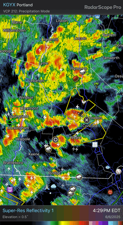
Swift water rescue for the chickens.
-
2 minutes ago, dendrite said:
1.25-1.5” hail in Henniker
It isn't often you can reach the 50 dBZ Donovan height around these parts, but that storm managed it.
-
2
-
-
17 minutes ago, Typhoon Tip said:
hey so ... we incurred a severe verification in my local township between 7 and 7:40 this morning. I bore witness to tree calving.. heh
Anyway, estimating a 60 mph gusting and I had hail up to between nickle and quarter sized.
I was wondering if that may have been EML loaded. This cell was bit of an over-achiever in an ongoing small cluster that came down Rt 2 in N Mass, and then sat showed a rather intense anvil radial expansion right over us, then all hell broke loose for 5 minutes - this was very wet microburst in appearance.
It was more or less tracking right on the edge of the steeper lapse rates. Most impressive that it was able to become surface based despite the time of day.
-
5 minutes ago, dendrite said:
@OceanStWx Do you guys have the official high for CON from yesterday? I know the 93° was before the outage. If I had to put odds on the high estimate I think I’d go…
95° 50%
94° 40%
96° 10%One of our techs is there now, but I'm not hopeful for recovering it.
-
50 dBZ over 30,000 ft at 7 am. Not too shabby.
-
1
-
-
7 minutes ago, dendrite said:
DAW 95
Are they broke again?
Live look...

-
4
-
-
1 minute ago, weatherwiz said:
Even keeps that pseudo EML through Friday. The shear is meh but that's some pretty hefty CAPE for these parts (MLCAPE 2500-3000). But yeah tomorrow probably has some capping issues but that weak boundary could be enough to set something off, especially early evening. Friday I think may have a bit more potential for storms.
Friday has that look, where we don't overturn the air mass on Thursday and end up doing the marginal risk on Friday instead.
-
14 minutes ago, ineedsnow said:
was that a confirmed tornado by Danbury?
Yes. There were two with the supercell by Great Barrington, one in CT, another in NJ, and several across parts of PA.
-
2
-
-
55 minutes ago, HoarfrostHubb said:
Not sure if anyone (ahem @weatherwiz), 30 years ago today was eventful in New England

Woof. I'm glad I never had to use 8 bit radar data. I'm also pretty sure ALY was still operating the 74C for this event, this was the summer they installed the 88D.
Can definitely infer some things about it with OKX data. It's roughly 40 kt Vrot over 80 nm from the radar. So considering it's already smoothing the details because it's 8-bit data, and the range from the radar means the large beam volume smooths it even more, this would've been impressive with today's super res.
-
3
-
-
50 minutes ago, ineedsnow said:
if the GFS is right we make it to atleast 12
48 minutes ago, CoastalWx said:GFS is unusable and tossed.
There is a pretty good signal on the EPS for a wet weekend after next.
-
1
-
1
-
 1
1
-

July 2025 Obs/Disco ... possible historic month for heat
in New England
Posted