

MGorse
-
Posts
2,226 -
Joined
Content Type
Profiles
Blogs
Forums
American Weather
Media Demo
Store
Gallery
Everything posted by MGorse
-

E PA/NJ/DE Spring 2025 Obs/Discussion
MGorse replied to PhiEaglesfan712's topic in Philadelphia Region
Interesting. -
E PA/NJ/DE Spring 2025 Obs/Discussion
MGorse replied to PhiEaglesfan712's topic in Philadelphia Region
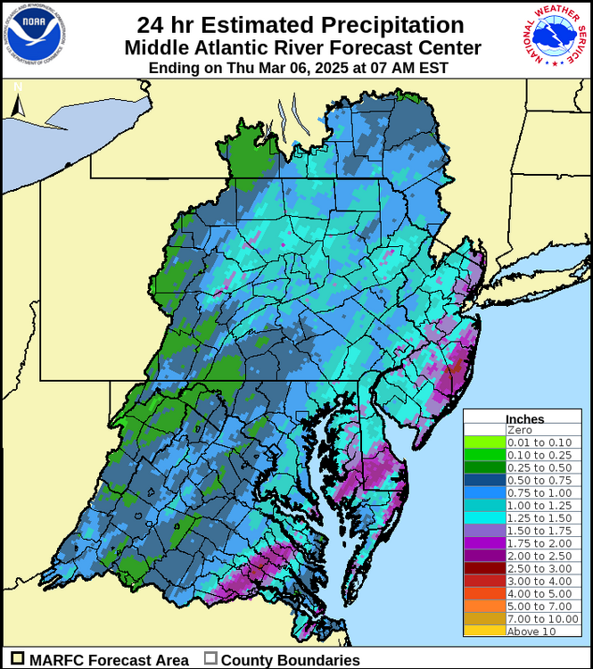
1.33 inches of total rain. The lawn is quite green. -
E PA/NJ/DE Spring 2025 Obs/Discussion
MGorse replied to PhiEaglesfan712's topic in Philadelphia Region
Imaginary drought? -
E PA/NJ/DE Spring 2025 Obs/Discussion
MGorse replied to PhiEaglesfan712's topic in Philadelphia Region
0.72 inches with light to moderate rain continuing and occasional thunder. Edit: Pouring again. -
E PA/NJ/DE Spring 2025 Obs/Discussion
MGorse replied to PhiEaglesfan712's topic in Philadelphia Region
58 mph gust at the KPNE airport. -
E PA/NJ/DE Spring 2025 Obs/Discussion
MGorse replied to PhiEaglesfan712's topic in Philadelphia Region
Severe thunderstorm warning here now. -
E PA/NJ/DE Spring 2025 Obs/Discussion
MGorse replied to PhiEaglesfan712's topic in Philadelphia Region
Looking forward to it! -
E PA/NJ/DE Spring 2025 Obs/Discussion
MGorse replied to PhiEaglesfan712's topic in Philadelphia Region
Seeing this convection on radar drifting east is like watching paint dry. Still waiting for rain here. -
E PA/NJ/DE Spring 2025 Obs/Discussion
MGorse replied to PhiEaglesfan712's topic in Philadelphia Region
Backdoor front just blew through here. Temperature went from 75 to 61 in a matter of minutes. A gusty northeast wind as well ongoing. Reached 81 this afternoon. -
E PA/NJ/DE Spring 2025 Obs/Discussion
MGorse replied to PhiEaglesfan712's topic in Philadelphia Region
Could be its cold bias showing up, but we shall see. -
E PA/NJ/DE Spring 2025 Obs/Discussion
MGorse replied to PhiEaglesfan712's topic in Philadelphia Region
Picked up 0.67 inches of rain yesterday. -
E PA/NJ/DE Spring 2025 Obs/Discussion
MGorse replied to PhiEaglesfan712's topic in Philadelphia Region
The strong winds are not until very late tonight and tomorrow. -
No thanks!
-
-
1.61” of rain here today. Much needed!
-
New phrase?
-
I-95 corridor, I-95 corridor...
-
At least that one is describing an area.
-
And the word "alert"...
-
A sharp upper-level trough passing overhead this afternoon with some enhanced convergence in the low to mid levels.
-
Norlun trough has become an overused phrase over the last few years.
-
You might need to take one of these up with you.
-
And the 18z NAM is a tad different. LOL. The main light snow is now focused with the upper-level energy arriving.
-
Bernie is good at what he does. I used to work with him back in the day. Agree that the NAM is probably overdone with the amplification.
-
Or it could be completely wrong.


