

sferic
-
Posts
2,496 -
Joined
-
Last visited
Content Type
Profiles
Blogs
Forums
American Weather
Media Demo
Store
Gallery
Posts posted by sferic
-
-
Here is to hoping northern Onondaga has a surprise tonight
-
1.5 inches of snow in Cicero this AM
-
About half an inch in Cicero; I like it here. Come the new year much more time up here as opposed to the Catskills and LI, looking forward to it
-
Back in Cicero now , I'll take 1 to 2 inches and be quite happy!
-
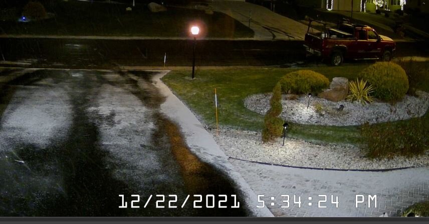
Cicero 5:30PM dusting of snow via webcam 28.8 degrees as monitored from Long Island
-
 1
1
-
-
13 minutes ago, wolfie09 said:
Oh gotcha..Hmmmm I only use my laptop in my back pocket so maybe he's using PC lol Not sure why the difference.. Maybe subscription?

I pay the $6.99/ month, any other paid sites you recommend? Why isn't the ICON on pivotal?
Thanks!
-
5 minutes ago, wolfie09 said:
GFS still showing a rain to snow system on Saturday/Sunday but not so fast says the NWS lol
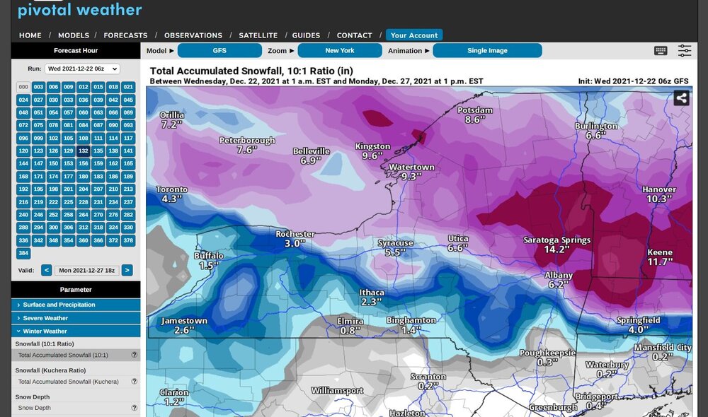
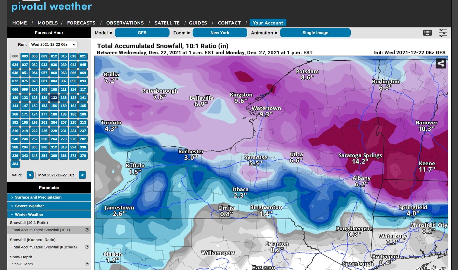
Looking into the
details... there remains uncertainty in an area of low pressure
which would impact the region Christmas -Christmas night. The
GFS has been persistent with a deepening area of low pressure
tracking across NYS while other models show a much weaker system
tracking to the south. The GFS isn`t favorable in the overall
zonal pattern across the region Saturday.
.thumb.png.ce484685820184db301faa11061d66d6.png)
Why is your graphic different than mine on Pivotal ?
Thanks !
-
Headed to Cicero for 2 weeks tomorrow, then back to Long Island for a week then back to Cicero for rest of winter
Hopefully surprises ahead
-
1
-
-
Leaving Liberty NY for CIcero Thursday, hopefully a couple of inches over the xmas wknd
I love being able via PLEX to watch the local Syracuse TV channels wherever I am. Good mets
-
1 hour ago, TugHillMatt said:
If you don't feel like stabbing a pencil in your eye, go read BGM's latest forecast discussion. You'll feel the urge afterwards.
Yeah, 4/30 for bgm and 7/30 ensemble members for 2 inches next wknd
-
Cicero Home cams show coating on grassy and non paved surfaces 32.7
Liberty NY (Where I am now) 32.2 Rain
-
Back in Liberty NY now; I can see possibly an inch here maybe, but the majority mixed.
-
11 minutes ago, TugHillMatt said:
For now, it's watching the snow fall in Tahoe:
Tahoe CityDowntown Webcam | Tahoetopia
CAZ072-NVZ002-132330-
/O.CON.KREV.WS.W.0003.000000T0000Z-211215T0600Z/
Greater Lake Tahoe Area-
Including the cities of South Lake Tahoe, Truckee, Stateline,
and Incline Village
320 PM PST Sun Dec 12 2021

...WINTER STORM WARNING REMAINS IN EFFECT UNTIL 10 PM PST
TUESDAY...

* WHAT...Heavy snow expected. Total snow accumulations of 2 to 4
  feet, except 4 to 8 feet above 7000 feet. Sierra ridge winds are
  expected to exceed 100 mph with occasional gusts 40 to 50 mph
  possible in lower elevations.
Now to leave Cicero and head to the greater Lake Tahoe area
-
 2
2
-
-
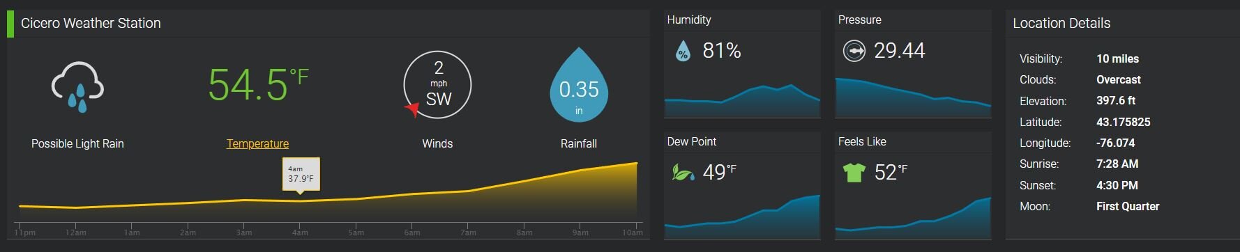
Latest stats from my Cicero Weather station.
Posted it to Weather Underground last night, not sure why it says "OFFLINE" while 2 others are "ONLINE"

-
1
-
-
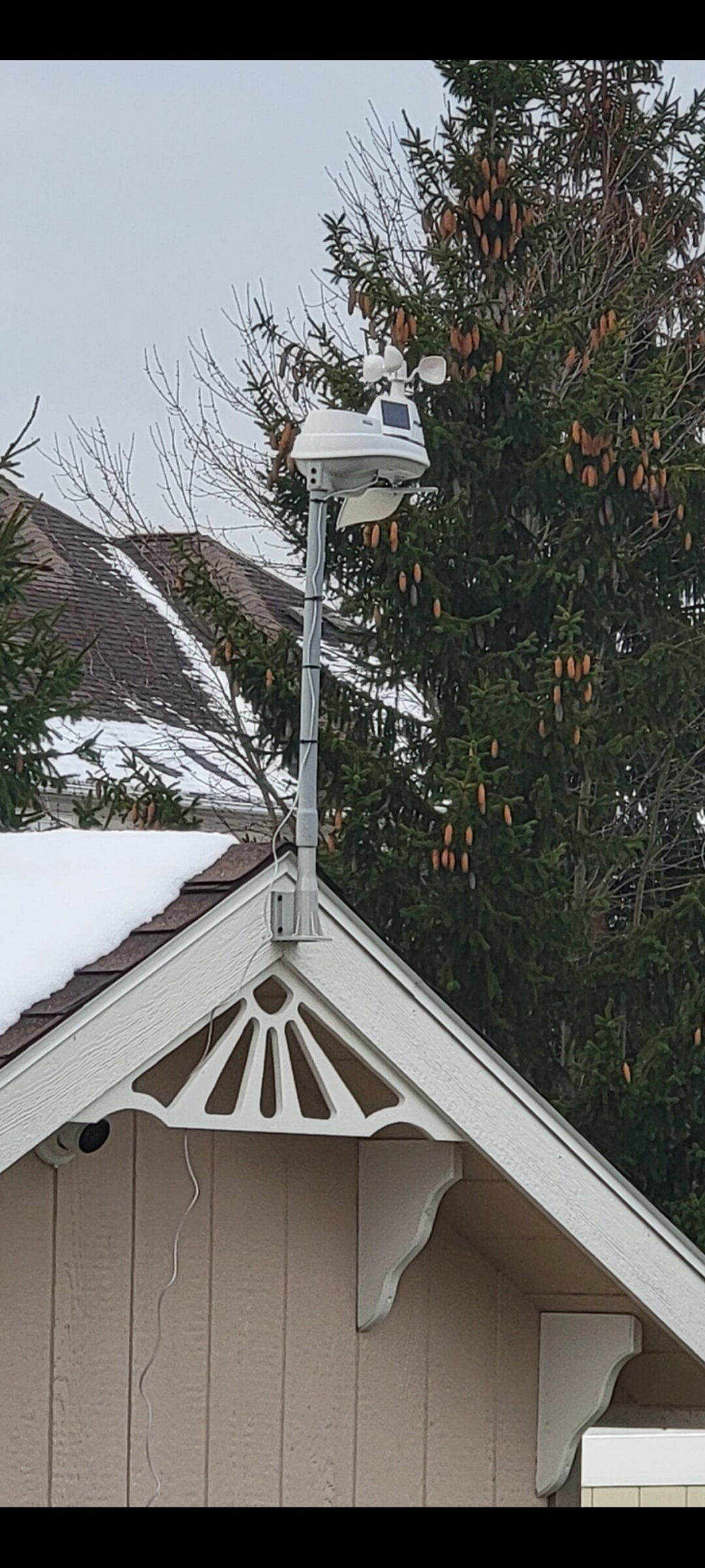
New Acurite Weather station mounted today in Cicero. Later on I'll connect to Weather Underground

-
7
-
-
@Ericjcrash have we both moved north ?
-
1
-
-
15 minutes ago, TugHillMatt said:
This is one of those situations I was telling you about. We get TONS of virga here. Seems there's always dry air... synoptic "sucks" here...at least since I have lived here.
Yes, I see !
-
Radar seems good. I'll take a sold inch

-
Can tonight overachieve and surprise with an inch or two or half an inch is the max?
-
3 inches in Cicero overnight, nice.
Maybe a dusting tonight to whiten everything up would be nice
-
2
-
-
Cicero 10:35PM Heavy Snow
-
 1
1
-
-
Cicero: nada to an occasional flurry
-
Just now, Blue Moon said:
My snowiest winter was 2010-2011.
We got 14".
14 inches?
-
2 minutes ago, TugHillMatt said:
Yeah, I am WSW (almost due West) of you. Northern Onondaga county in general retains snow depth better than the city it does. I have only been here for 2.5 years (3rd winter here) and Syracuse almost always seems to have less (sometimes significantly so) snowfall than us.
Ice storms aren't too common as Lake Ontario and a southerly wind can scour out low level cold air pretty quickly. As is quite evident, I hate how warm air so quickly invades this region...my biggest weather pet peeve of living here. The hills to the south of Syracuse create a mini-Chinook from downsloping on a south wind. So maddening. Sometimes, the warmth gets hung up on the hills though and we can get some cold air damming that funnels in on an E or NE wind from the Mohawk Valley. I have seen Tully in the 40s before, while we are in the low 30s.
The dreaded rain/mix/snow line. I thought I was getting away from it as well (moving from Lancaster, PA). But, instead of it moving in from the ocean, we deal with it from dying primary lows that move up along Lake Ontario and warm air surges north through the Finger Lakes. Sleet is actually pretty common here...moreso than freezing rain. We need secondary lows to take over more quickly...which has greatly been lacking since I moved here.
We want to see a nice retrograding Low sit off the coast of Massachusetts and filter synoptic moisture in along with a WNW wind off Lake Ontario. That's when Syracuse gets feet of snow in a week.
Snow depth here "can" reach 3 to 4 feet. Because Lake effect snow compacts easily and snowfalls build one on top of another and keep pressing down...I would say a typical max snow depth (usually in February) would be 24 to 30 inches.
Thanks for that treasure chest of such valuable info !
-
1
-

.png.ffc87d48039caf5411c01af0809a64bc.png)
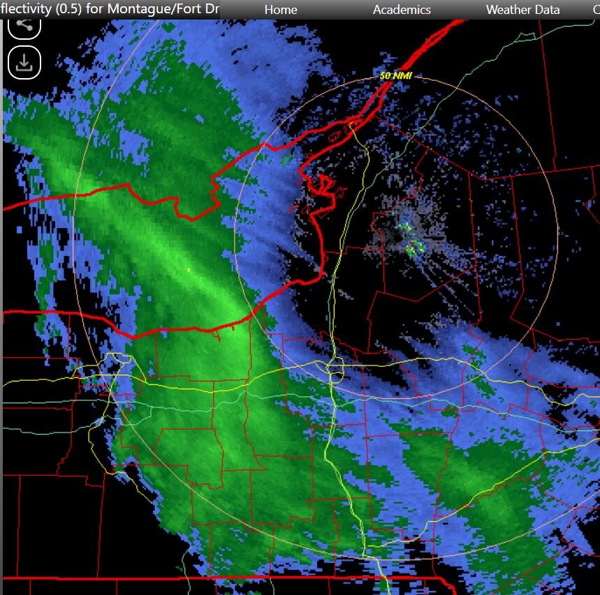
Upstate/Eastern New York-Into Winter!
in Upstate New York/Pennsylvania
Posted
What is the source of this graphic? Thank you