Fred Gossage
-
Posts
173 -
Joined
-
Last visited
Content Type
Profiles
Blogs
Forums
American Weather
Media Demo
Store
Gallery
Everything posted by Fred Gossage
-
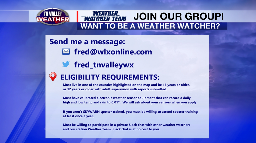
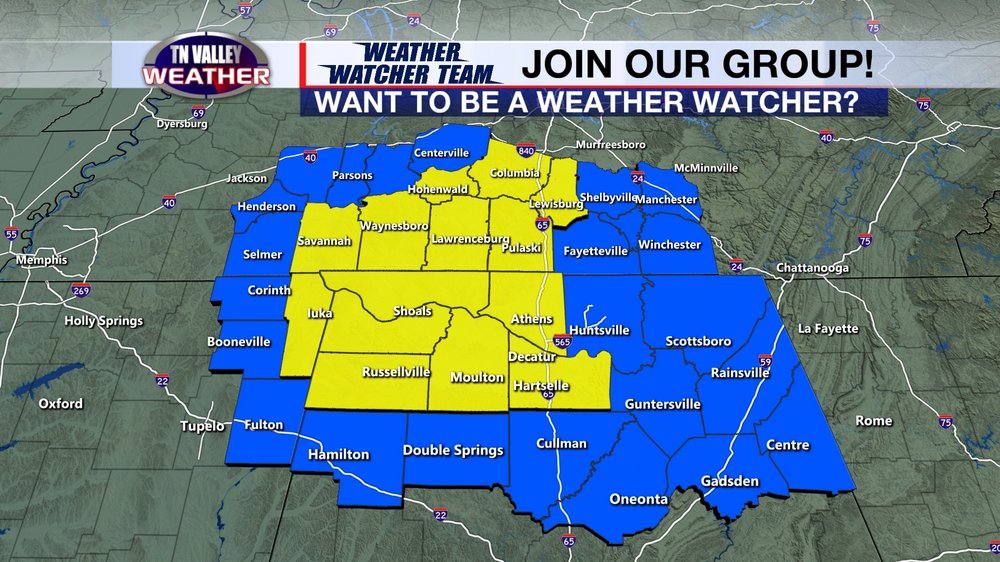
https://www.tnvalleyweather.com/post/here-s-how-you-can-help-the-tennessee-valley-weather-team Hey guys! Our weather operation is looking to build a team of volunteer community weather watchers across southern middle Tennessee, northern Alabama, and northeast Mississippi to assist in our weather coverage and help us gather reports and information for local NWS offices, local EMA, and other local media outlets (yes, despite us being local media on the digital side, we play nice with the TV folks and consider them friends and partners instead of direct competition). If you live in the area outlined on the map in the post linked above and you have a strong interest in weather, are SKYWARN spotter trained and/or have weather instrumentation that can report daily highs, lows, and precipitation, you may be a good fit for our group! The post linked above contains more information on what we're trying to do and how you can contact me if you may be interested. We already have 24 members signed on, after just recruiting for a couple of days, and we are looking to build a large team across the area. Thanks so much for your help! ABOUT TENNESSEE VALLEY WEATHER: Born from the legacies of WLX Radio / Radio 7 Media and the long-running digital weather operation Shoals Weather, Tennessee Valley Weather has been operational since April 2020 as a 24/7 all local digital weather channel and social media operation covering southern middle Tennessee, north Alabama, and northeast Mississippi. The Tennessee Valley Weather Channel is equipped with a LIVE dual polarimetric X-Band Doppler Radar located in Lawrenceburg, TN (and in the works to deploy a more powerful, farther reaching, dual polarimetric Baron radar to cover ALL of southern middle Tennessee, northwest Alabama, and northeast Mississippi... with real-time data from the current radar and the planned future radar being sent to local NWS offices and EMA offices to assist in real-time warning operations and EM operations), the Baron Lynx/VIPIR storm tracking and graphics display system, the largest LIVE high definition PTZ skycam network in the Tennessee Valley, and the largest weather team in the Tennessee Valley... with five full-time team members and one part-time tropical, severe convective, and long-range weather analyst.
-
The Wayne/Lawrence County F5 happened coming out of the 1997-1998 Super Nino. The 1998-2000 La Nina had not developed yet.
-
I will just say that all those analogs above should show that the general large scale pattern is there for a potentially active severe weather season ahead, and not just in numbers but in the potential for a large scale intense event or two. All four of the years highlighted in the analog chart had high-end days. When you use certain "celebrity" analogs, people instantly blank out and think you're automatically calling for a repeat of the "celebrity" event, and I'm not, and we're not going there. Even if you have the exact same setup on the hemispheric or global level, it is up to individual synoptic systems to take full advantage of the background state, and then it is up to the mesoscale of one of those to take full advantage of its synoptic setup. And that is something we just can't know until we are running up on an individual system. But with everything in place, I just can't see how we can avoid an active stretch in a few months from now, with a higher-than-usual chance of a headliner type day or two.
-
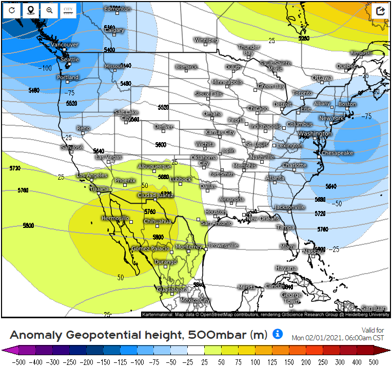
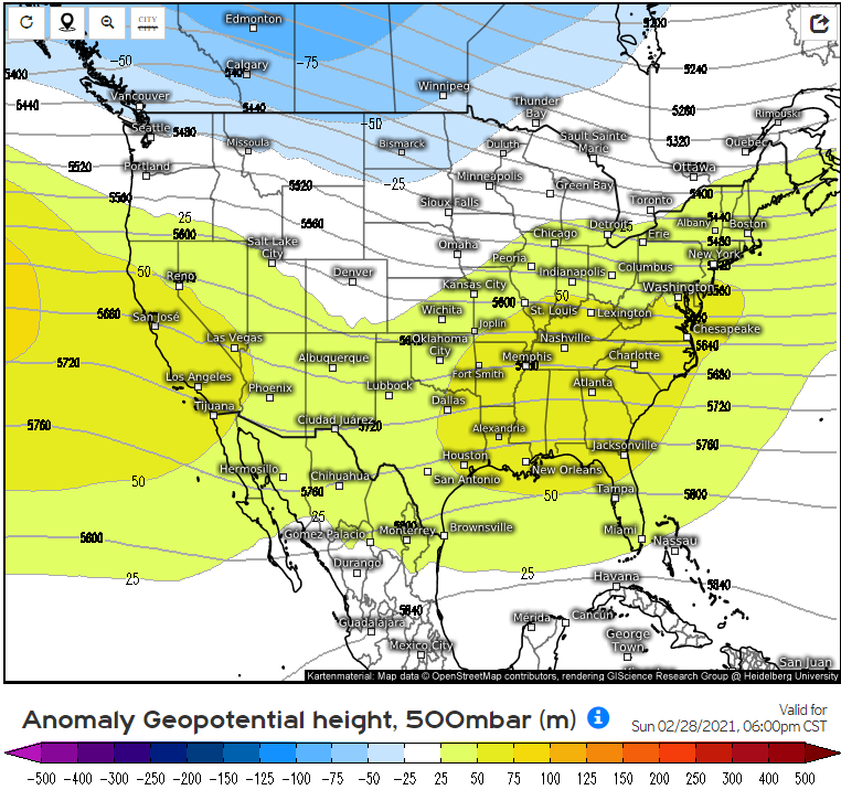
The pattern through February on the Euro weeklies shows low amplitude suppression will continue, with only flat, low-latitude oriented subtropical ridging as we begin to start March. That general layout of everything supports the idea that suppression of the pattern doesn't back off until we start heading into spring severe weather season. That particular pattern there is almost a carbon copy of the February pattern from the two listed analogs above that targeted Dixie Alley in April instead of the late winter. I won't say which two because I don't want to be labeled an alarmist by people on here that may not know me, but the winter pattern so far and what the Euro weeklies show for February does not support the other three analogs on the Tidbits list.
-
Looking ahead at longer range stuff, the January analogs from tropicaltidbits.com would suggest an active severe weather season is ahead. Three of those speak for themselves, but for those that don't recognize 1976 that much: March 1976 holds the record number of tornadoes for any March in the United States in official tornado records. There were four separate outbreak systems that month alone. The top four of five January analogs there on Tidbits suggest an active and possibly violent Dixie Alley season ahead, and the fifth analog would've been the exact same, but there were STJ interference issues that year. We are polar jet driven this year.
-
It was positive as of the weekly ENSO update this week with last week's numbers. Region 4 was -1.2C and Region 1+2 was -0.8C. Since then, Region 4 has cooled and Region 1+2 has warmed.
-
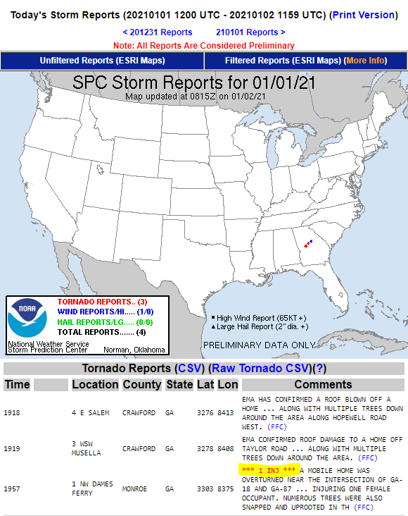
It's just south of the overall Tennessee Valley area but close by and within Dixie, but we've already had our first tornado injury of the year. And despite the ENH Risk from the day before not materializing, this is at minimum the fourth system in a row over the past few weeks to produce tornado damage in one of the Dixie Alley states. It's going to be a long 5-6 months ahead...
-
The +TNI is now officially observed to be in place. This would be a TNI value of +0.7, getting not far off from a significantly positive TNI already, and this will only strengthen over the next few months as the cooler water shifts into western areas as the La Nina decays. https://www.spc.noaa.gov/misc/CSWW-2015/afternoon1/002_csw_workshop_mar_11_2015_version2.0.pdf https://journals.ametsoc.org/view/journals/clim/26/5/jcli-d-12-00128.1.xml?tab_body=fulltext-display Here are the links to explain why this is important...
-
The latest PDO for November is in. Depending on whether you use CPC (here) or NCDC, it is either -1.71 or -1.55... both of which put it into "significantly negative" territory... and well ahead of any modeling. Look at the CFS, for instance, which gets the PDO to -2 going into April. Yes, the North Pacific is warm, but it's about the placement of the warm and cold anomalies. Having that horseshoe of cold in the Gulf of Alaska and the west coast of the USA with warmer anomalies in the offshore NPAC is classic -PDO...
-

December 2020 Medium/Long Term Pattern Discussion.
Fred Gossage replied to John1122's topic in Tennessee Valley
I'm very much not talking about the full winter. I am simply saying that, for the next few weeks, we are heading toward a pattern that would possibly favor one or more severe weather threats between now and Christmas. I honestly expect us to flip back and forth between the current pattern and the coming pattern for the rest of the winter. CFS in particular wants to take the MJO back to the Pacific during some point in January and into February. I kinda expect it to do that given what we have seen thus far. February 2011, the MJO didn't budge from the Pacific. My post had nothing to do with expectations for the winter overall. It was telling folks in this area to start paying attention to systems ejecting out of the Plains between now and Christmas. -
December 2020 Medium/Long Term Pattern Discussion.
Fred Gossage replied to John1122's topic in Tennessee Valley
MJO looks to be going toward a position a bit more typical of La Nina as we head forward, and AAM looks like it's going to start tanking soon. I would start keeping an eye on medium range guidance for one or more severe weather threats to start showing up between now and Christmas or so. No real specifics other than that, but it may be time to start having our eyes open... -
2019 ENSO
Fred Gossage replied to AfewUniversesBelowNormal's topic in Weather Forecasting and Discussion
Colder anomalies going more west-based as the La Nina weakens is a major positive Trans-Nino Index configuration. I know you're a bit west to have to worry about classic severe weather, but that is a big red flag going into spring. -
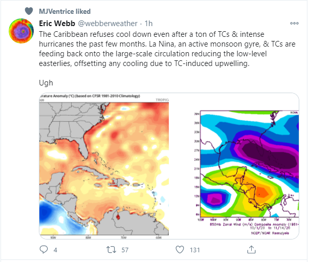
One of the hopes I had was that having so many tropical systems in the Caribbean would lead to the water temperatures getting worked over and that would introduce boundary layer moisture quality concerns like we saw in the 2005-2006 cool season into spring after the 2005 hurricane season that had systems target the same areas. Our higher quality boundary layer moisture in Dixie Alley, until about May, comes from the Caribbean... not the Gulf of Mexico. It appears any hopes of having that warmer near-surface water being worked over is not happening. That was probably one of our better chances of finding a way to skirt around something serious happening as a result of the -PDO/+TNI combo that's building, and it looks like those hopes are dashed. With the trade winds setting up in western regions to help drive cooling there and the coastal Gulf of Alaska and West Coast of the USA cooling, leading toward a more classic -PDO configuration going forward (even though the whole NPAC won't be cooler), pretty much all the large scale red flags are there... not just for an active time east of the Plains... but for the door to be open for something bad to happen in terms of a system with the potential for large scale violence. All of this put together into one setup is the kind of background state you most often have when bad things happen. My main questions going forward are overall amplitude of the large scale pattern this cool season and how that affects placement of the jet stream... and how that affects the timing of when Dixie Alley is most under the gun. Seeing the subtropical ridge stay stout but centered at a lower latitude off the Southeast coast and from the Bahamas eastward, and allowing cold shots to still frequent the east so far this fall, is unsettling to me. If the ridge during the cool season stays lower latitude in nature, that not only opens the door for systems to target the heart of Dixie well into April, but it provides a background pattern over the CONUS, in conjunction with the NPAC pattern that results from the -PDO and La Nina, for individual synoptic systems to be of a lower amplitude variety as well. Low-amplitude troughs, regardless of their tilt, tend to be more dangerous... especially in Dixie Alley... because of more subtle forcing out over the warm sector, more westerly deep-layer shear vectors, less focused linear forcing near the cold front, etc. Lower amplitude troughs are how we can get intense tornado events (4/7/2006, 5/18/1995, 4/8/1998 to name a few) here from even positive tilt troughs. April 3, 1974's trough started out negative tilt, but by later in the day before any of the F4-F5 tornadoes happened in Alabama, its trough had evolved into a lower amplitude positive tilt. We can only go by reanalysis data, but if it is correct, the troughs with both the 3/21/1932 and 1936 Tupelo event were probably both low-amplitude positive tilt. Low amplitude upper-level patterns are not good, regardless of trough tilt. Nothing is certain, but there are a lot of red flags there...
-
Thanks for your support! I'll be around at times, more frequently as this pattern continues to show its cards. From a Dixie Alley severe weather standpoint, I don't like what I'm seeing...
-
Posted by raindancewx in the main subforum's ENSO thread yesterday. Euro has finally caved, and it has a known warm bias. I'd say the lower-end of strong is within striking range. There are few models now that don't have a peak near or within at least the lower-end of strong. Given the continuous strong trade winds, it's not that hard to believe it may happen. I would consider a moderate peak, at least, very very likely. I have great concern with many of the models wanting to weaken the La Nina in a west-based form as we head out of winter into spring. That would set up a significantly positive TNI pattern. Google the Trans-Nino Index and its link to tornado activity.
-
2019 ENSO
Fred Gossage replied to AfewUniversesBelowNormal's topic in Weather Forecasting and Discussion
First-year La Ninas coupled with a -PDO tend to be unkind to Dixie Alley, and often times, there is enhanced drought in the Plains. However, even then, there can still be big events out there. May 24, 2011 and May 3, 1999 come to mind. There was decent drought in the Southern Plains in the fall of 1998 as we went into that La Nina. By the time we were rolling into the summer of 1999, some areas of Oklahoma were apparently above average in precipitation. You will find that most (definitely not all) Plains chasers are a very knee-jerk reaction and Plains inactivity = no activity anywhere at all type of crowd. -
2019 ENSO
Fred Gossage replied to AfewUniversesBelowNormal's topic in Weather Forecasting and Discussion
The big red flag to me is that the majority of the models end the La Nina (whatever intensity it is) as central to west-based as we head through late winter and toward spring. That sets up a significantly positive TNI pattern. You know all about what that means, in conjunction with the La Nina itself and a -PDO that is already -1.25 as of August (it peaked at -1.75 last winter and didn't get to -1.25 until after Christmas)... -
2019 ENSO
Fred Gossage replied to AfewUniversesBelowNormal's topic in Weather Forecasting and Discussion
Both were officially strong La Nina episodes, with 2010-2011 being a bit more robust. Both peaked with 3.4 at -1.6C or lower and held -1.5C or lower for three or more trimonthly periods. https://origin.cpc.ncep.noaa.gov/products/analysis_monitoring/ensostuff/ONI_v5.php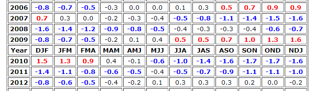
-
The idea of the colder anomalies being more central/west-based as we head through later winter and into spring is worrisome. That's how you get a +TNI pattern. You guys research Trans-Nino Index and its relation to tornado activity. August PDO is in now, -1.25. Combination of significantly negative PDO, a decent La Nina, and potential for a significantly +TNI pattern because of the Nina ending central/west-based definitely supports Jeff's comments in this thread and other ones about being concerned about late winter and spring severe weather in Dixie Alley.
-
Historic Tornado Outbreak April 27, 2011
Fred Gossage replied to CUmet's topic in Weather Forecasting and Discussion
That was a case where the scoured pavement was where the road went over a culvert for a drainage ditch or something similar, providing a structural weakness for the roadway. If it's able to be proven that the pavement was completely flat on the ground below... and in relatively good condition... that can prompt a very high damage scale rating, especially if there is secondary supporting evidence in the area. -
Devastating tornado strikes Joplin, Missouri
Fred Gossage replied to Hoosier's topic in Weather Forecasting and Discussion
It's not mandated. It's a decision that each school system makes, and not completely all of them close. To be honest, it's probably more for liability reasons than anything, after the Enterprise, AL incident in 2007. -
Devastating tornado strikes Joplin, Missouri
Fred Gossage replied to Hoosier's topic in Weather Forecasting and Discussion
That's mainly a Dixie Alley thing, after the Enterprise tornado... and the school closings happen most often in Alabama specifically. -
Historic Tornado Outbreak April 27, 2011
Fred Gossage replied to CUmet's topic in Weather Forecasting and Discussion
I'm usually one of the first to pick on you when we have a higher end threat, and I know you've seen some very ominous comments from me on other forums today.... but I understand and really respect this more conservative approach... especially when we do have mesoscale questions that need to be answered. However, the one point I want to make about the early initiation.... is that both of these cases so far... have been along west to east oriented boundaries... and it's extremely easy to get initiation in these cases, as compared to along a more north to south oriented boundary... because, most of the time, you have a better chance at EML advection overtop the warm sector in the more north to south scenario. It's an understandable concern, but it may not be quite as comparable. At any rate... especially with convection just upstream... I definitely understand the conservative approach... but with several ongoing things that are leaning away from the convection developing into this big cold-pool driven B.S.... there are some times, as we've seen before, when you just don't need to ignore the synoptic environment that is ultimately driving the mesoscale. I'm sure most people thought, by 4 pm, last April 24th... that the Alabama portion of the HIGH would be a bust... but we had an EF4 and multiple EF3s that night. -
Historic Tornado Outbreak April 27, 2011
Fred Gossage replied to CUmet's topic in Weather Forecasting and Discussion
I don't either... but I'm not quite sure the SPC WRF is right with the morning convection being as widespread and organized as it shows. Everything in the activity north of the Louisiana supercell cluster is weakening... and this is going to make it harder and harder to get a large MCS with an organized cold pool... especially as capping increases ahead of these storms overnight. This will also make it easier for them to gain latitude as the mid/upper winds become more SW to NE as the trough deepens overnight and into the morning. I think there will be convective remnants... but I think the SPC WRF is too organized with it... and too slow (when looking at earlier panels, it's a few to several hours behind reality... and this is a very common bias in the model... with non-discrete convection). I think a halfway medium between the RUC and SPC WRF is probably the right way to go. -
Historic Tornado Outbreak April 27, 2011
Fred Gossage replied to CUmet's topic in Weather Forecasting and Discussion
FoxAlabamaLive.com ... if you want to watch our live streaming coverage tomorrow guys. We will have live streaming chasers in the field, as well as giving the FasTrac, VIPIR, and GR2Analyst systems a good workout. I'll be the bald guy in the background in a white shirt and red tie.