

CT Rain
-
Posts
25,962 -
Joined
-
Last visited
Content Type
Profiles
Blogs
Forums
American Weather
Media Demo
Store
Gallery
Posts posted by CT Rain
-
-
2 hours ago, Damage In Tolland said:
What about June 2011? What made that one stay OTG from the valley right thru the 1,000+ foot hills of Brimfield, Monson, Charlton, and Sturbridge?
The storm was more discrete and there was more instability - I think better low level shear in general.
-
1 hour ago, OceanStWx said:
Because conditions were more akin to Plains severe weather than New England?
But tornadogenesis did occur once that supercell hit the CT River Valley.
A large area of research right now is on what determines whether a supercell can sustain a long tracked tornado like 2011, vs one that doesn't produce or produces brief tornadoes. The prevailing theory is RFD temp, but it's ongoing research at the moment. But basically a colder RFD will tend to rush out and overwhelm any low level tornadic circulation, vs a warmer RFD that can become buoyant again and sustain a tornado.
The fact that Hamden, CT managed a tornado and 100 mph microburst on 5/15 with a 55F water temperature just south is nuts.
EML everytime.
-
 1
1
-
-
1 minute ago, OceanStWx said:
The terrain is such a big factor in New England. Most tornadoes in our forecast area end up occurring on or near lakes, in these N/S or NW/SE oriented valleys.
The supercell in N CT did produce a waterspout on the N-S oriented Barkhamsted Reservoir.
-
30 minutes ago, OceanStWx said:
If they thought there was evidence of a tornado, they would've checked it out.
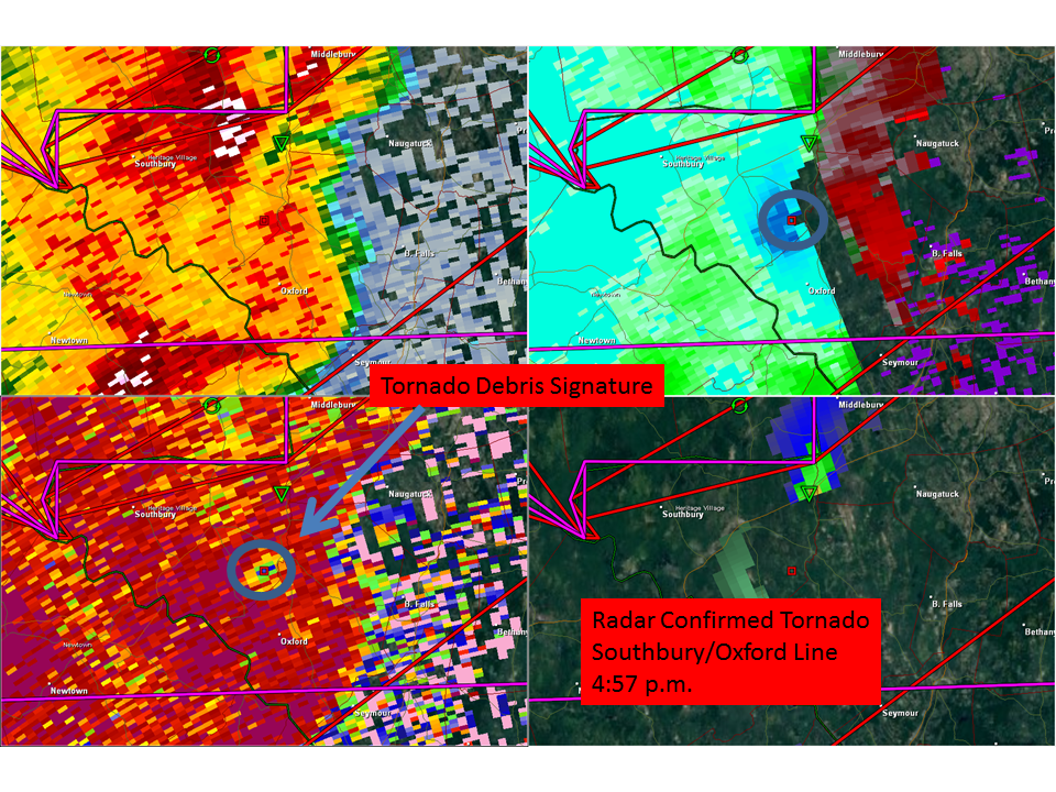
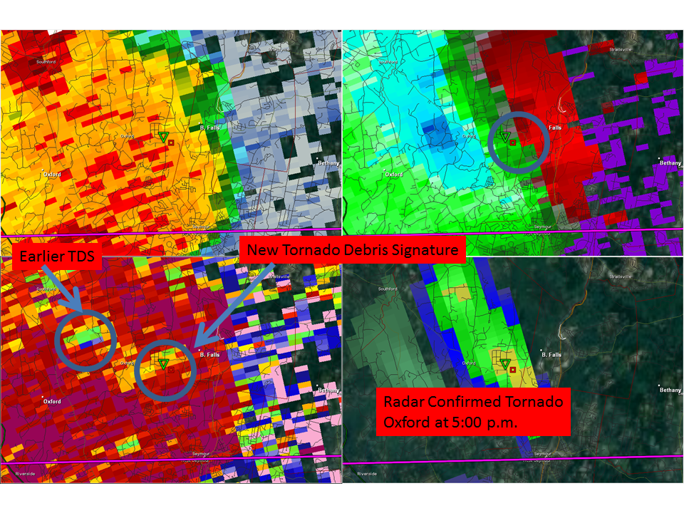
What was likely occurring with these tornadoes was a cycle of RFDs. RFD would would develop, spin up a brief tornado, then the RFD would overwhelm the circulation and create a large swath of straight line wind damage. Then the process would start again.
And on radar it’s pretty clear that’s what was happening. Hell, OKX was sampling 102 knots of inbound wind over New Fairfield!
Interestingly, the tornado spun up as the RFD surge reached the Housatonic River. Local backing of the low level wind?
I think there were a couple tornadic circulations in Oxford and Bethany and they found 2. Could have been more.
-
41 minutes ago, JKEisMan said:
The original town survey list didn’t include New Fairfield and the survey report from yesterday only referred to Brookfield. Again, even the final report today didn’t refer to actual consultation or survey in New Fairfield, so seem tacked on. Just wondering if they actually went to town - just a question. I realize there are probably limited resources for survey work.
They added New Fairfield. I know they were in Brookfield - but you could also see the swath continue on the other side of the lake in New Fairfield.
-
The damage in SW CT is unbelievable. Miles and miles of snapped trees in a swath stretching from the NY border to just north of New Haven. Epic.
-
1 minute ago, Ginx snewx said:
Beyond relieved I wanted no part of that disaster. Watching Ryans station right now. This was Epic in Ct. That hail damage is sick too
Yeah the damage is remarkable.
-
-
Well that was something.
-
1
-
-
It's amazing how similar the CAMs look for tomorrow afternoon.
-
1 minute ago, HoarfrostHubb said:
Not sure anyone mentioned, but May 4th has been confirmed as an EF1 in NH
36 mile path. Sweet
Wow - where'd you see that?
-
2 minutes ago, OceanStWx said:
The key for parts of WNE is how much clearing we get in the wake of the morning shortwave. The NAM does have subtle height rises and subsidence following it, so that could suppress cloud cover and provide some insolation.
Yeah the timing actually looks favorable for some nice clearing midday.
-
6 minutes ago, Ginx snewx said:
I was actually looking at RH fields and 5H temps.
Same though.
-
12 minutes ago, Ginx snewx said:
Euro with a 7/10 split
I wouldn't worry about a global models QPF output since they can't explicitly resolve storms.
-
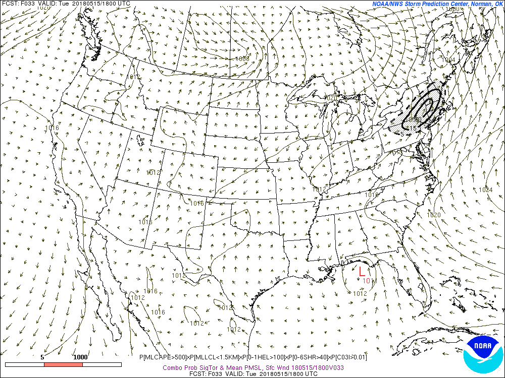
1 minute ago, Damage In Tolland said:
There’s a big Tor potential. Could be an infamous day in our SNE annals
I don't see it. Maybe from a storm interaction or some locally backed winds for whatever reason.
The 6z NAM was concerning with the tor potential but all the other models veer the low level winds after the morning. You're left with straight hodographs. Any tornado potential is definitely very isolated. If something changes - like a mesolow or something that can serve to back low level winds like the 6z NAM had then I'll be more interested.
-
1
-
-
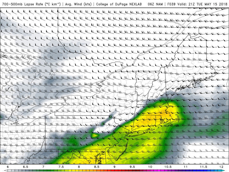
What's impressive this morning is that the EML looks even more legit. NAM and GFS close to 8c/km with mid level lapse rates.
The SREF also is bumping up the CAPE - especially over CT - and now has some pretty impressive sig tor probabilities showing up.
-
1
-
-
27 minutes ago, Ginx snewx said:
Nice glad to see you deleted that Meh response to Ryan you posted last night. W and CCT under the gun
Lol that’s funny.
With the EML in place especially southern areas watch for some elevated stuff making it to the coast.
-
1
-
-
Got some EML air lurking nearby on Tuesday. Worth watching.
-
1
-
-
40 minutes ago, Quincy said:
Based on the density of reports, MDT will likely verify in the Utica-Albany corridor (I realize ALB wasn't in the MDT risk, but the verification will show that the would have, partly due to population density and number of reports), but there are some gaps in reports farther north. Some of that was due to more cellular activity, but even up near the NY/VT border, storms had converged into a line, before passing into VT.
There's also virtually no people in a huge chunk of the Adirondacks so it's pretty hard to get reports in that area.
-
1 minute ago, powderfreak said:
Same with MVL... gusts 40-50kts and higher in the radiator sites is impressive.
How'd the Mansfield mesonet site make out?
-
GFL is also in a hole in the ground. Makes that 53 knots even more impressive.
-
50 knot SCH too
-
2 minutes ago, OceanStWx said:
That is really surging out and bowing now along 91 (viewed from GYX).
For sure. LSC FTW.
-
Nice meso and BWER in southern Orleans Co VT
May 15 2018 Severe Threat SNE
in New England
Posted
I just uploaded our coverage from Tuesday.
Here's when sh*t started getting crazy.