

CT Rain
-
Posts
25,962 -
Joined
-
Last visited
Content Type
Profiles
Blogs
Forums
American Weather
Media Demo
Store
Gallery
Posts posted by CT Rain
-
-
Albany is about to get slammed.
-
Downburst just south of BTV.

-
1 minute ago, OceanStWx said:
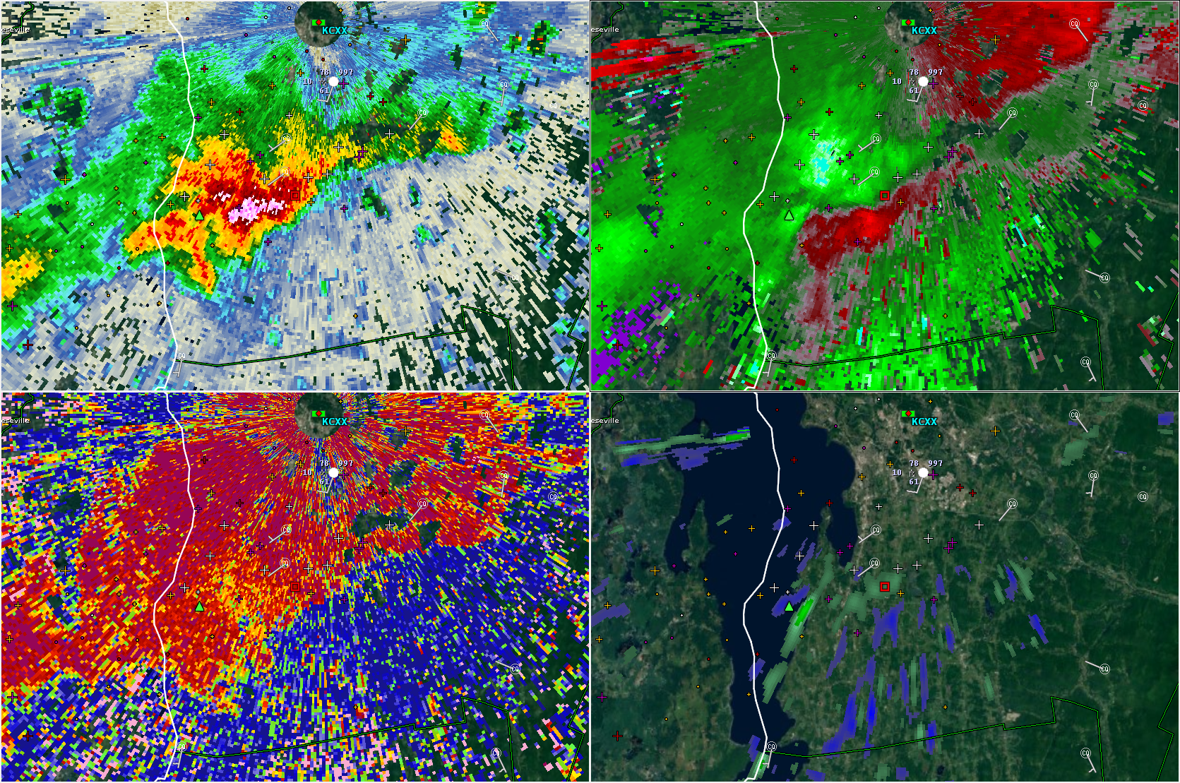
Nasty storm going through Franklin County, VT. Big BWER on it, but CXX can't see the low level rotation at all.
That one has the strongest mid level meso of the day. Given the amount of beam blockage there it sure could be dropping a tor.
-
Scott's about to rock in Stowe.
-
25 minutes ago, OceanStWx said:
-1 NROT with the storm in western MA. That's probably the "lowest" value I've ever seen.
Considering +1 is important for tornadogenesis in New England.
Anticyclonic tornado in the Berks? lol
-
2 minutes ago, OceanStWx said:
It's a nice left mover, so probably still a bit elevated.
Yup - I'm surprised the RM fell apart so quickly over NY.
-
Just now, weatherwiz said:
I was just reading the outlook and they mentioned numerous severe gusts across MI...I don't think the thermodynamic environment there was impressive either. Perhaps the high Dcape will help? Maybe it is a bit noteworthy too that we were able to get some pretty decent gusts yesterday and you would think today conveciton would be much deeper. but idk...MLcapes less than 1000...tough to get truly excited
You also have 60-70 knots right off the deck. Not going to take much to mix those winds down.
-
Definitely a concerning setup today in N NY and VT. Substantial low level shear, low LCLs, and at least some instability building this afternoon.
-
51 knots HPN
-
 1
1
-
-
38 knots MGJ. Inverted V FTW.
-
1 minute ago, CoastalWx said:
Yeah we had some heavy stuff move through and not one bolt. Probably means lapse rates blow aloft. Thought it would be better. Hopefully that stuff in NY can produce.
That stuff in NY is struggling.
-
2 minutes ago, CoastalWx said:
looks like meager cape in mid levels screwed us. I’ll take the rain though. We’ll see if the stuff along the juice axis in srn NY survives.
It's interesting to watch the change in the models from 48 hours ago to now. The steep mid level lapse rates are clearly not here lol. Decent coverage of downpours though back this way with nice mid level moisture.
-
8 minutes ago, ORH_wxman said:
I know Sam mentioned the squalls tomorrow afternoon, but don't sleep on a bit of snow too in the evening/night as well tomorrow night with the deepening of the ULL just as it passes our longitude, almost wants to throw an IVT back, so there could be some currier and ives stuff that blossoms. Doubt it will be a big deal, but if someone gets an inch or so it wouldn't be shocking.
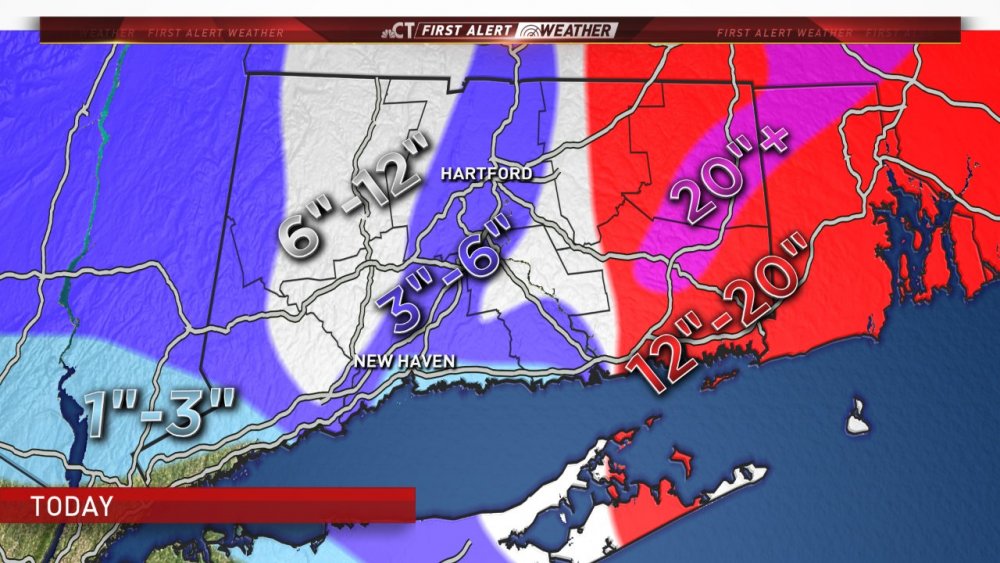
This could be a rare upslope event into Litchfield Co CT. It's tough to get it without a good synoptic assist.
-
10 minutes ago, sbos_wx said:
I just notified Fisher there are multiple people reporting it so, we'll see.
To be honest, we get so many bad snowfall reports in the media (some intentional, some not) it's easy to toss the outliers at first.
-
Isoplethed this as best we could.
-
37 minutes ago, JC-CT said:
Nice! Where in Scotland? Josh wants to head up there to take some pictures of the jackpot zone.
-
1
-
 1
1
-
-
Just now, Sugarloaf1989 said:
5" here, down to just flurries.
lol you mehd your way to 5"
-
Only 4" on my snow board in WeHa.
-
2 minutes ago, ORH_wxman said:
When the ORH/Windham county band started pivoting, that screwed you and Kevin's hood....just choking on the exhaust. You may finally get some goodies for a few hours when that collapses....the whole thing is slow to leave, so you could get a few hours of decent rates.
Yeah woof. That was unpleasant.
-
Just now, Sugarloaf1989 said:
School cancelled for flurries, LOL.
It's not snowing hard there yet?
-
Mid level magic IMBY.
We take.
-
2
-
-
2 minutes ago, ORH_wxman said:
Western band is sliding east while the eastern stuff is still pushing NW....might see a pretty sick pivot band where the two meet up...or maybe new stuff forms too.
Who knows... maybe an HFD crusher???
-
Hard to figure out where that western band will setup and pivot. It's definitely scooting east pretty good. Does it continue or does it slow and pivot?
Snow is picking up here for sure... probably close to moderate.
-
Only about 1.5" here so far. We were stuck in that subsidence zone earlier. Blah.


General Severe Weather Discussion 2018
in New England
Posted
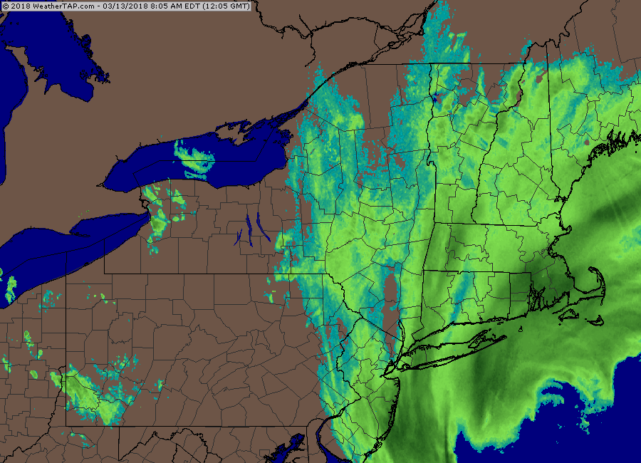
Radar shows ~68 knots over Mansfield.
Scott's poor picnic tables.