

CT Rain
-
Posts
26,076 -
Joined
-
Last visited
Content Type
Profiles
Blogs
Forums
American Weather
Media Demo
Store
Gallery
Posts posted by CT Rain
-
-
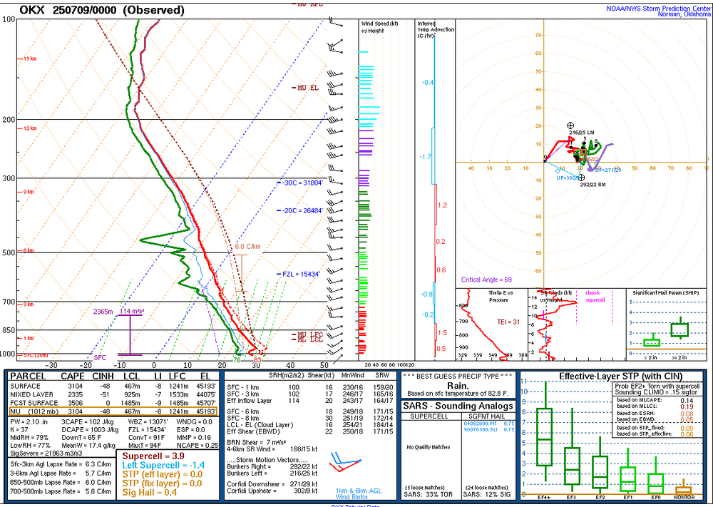
No shortage of instability at OKX
-
 1
1
-
-
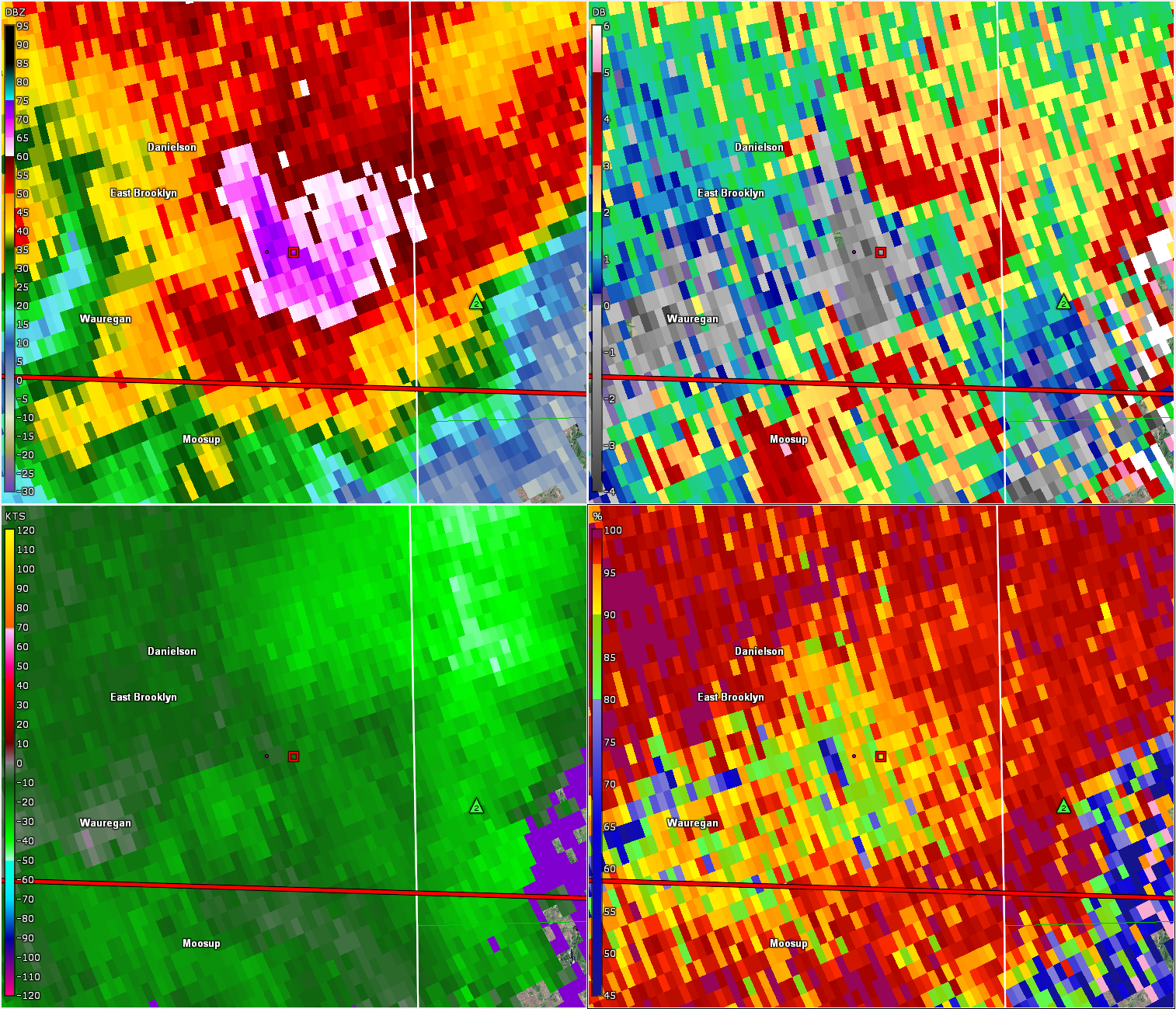
Very impressive hail signature in NE CT earlier. Not surprised by the 1.75" hail reports.
Tons of wind damage across the state.

-
5
-
-
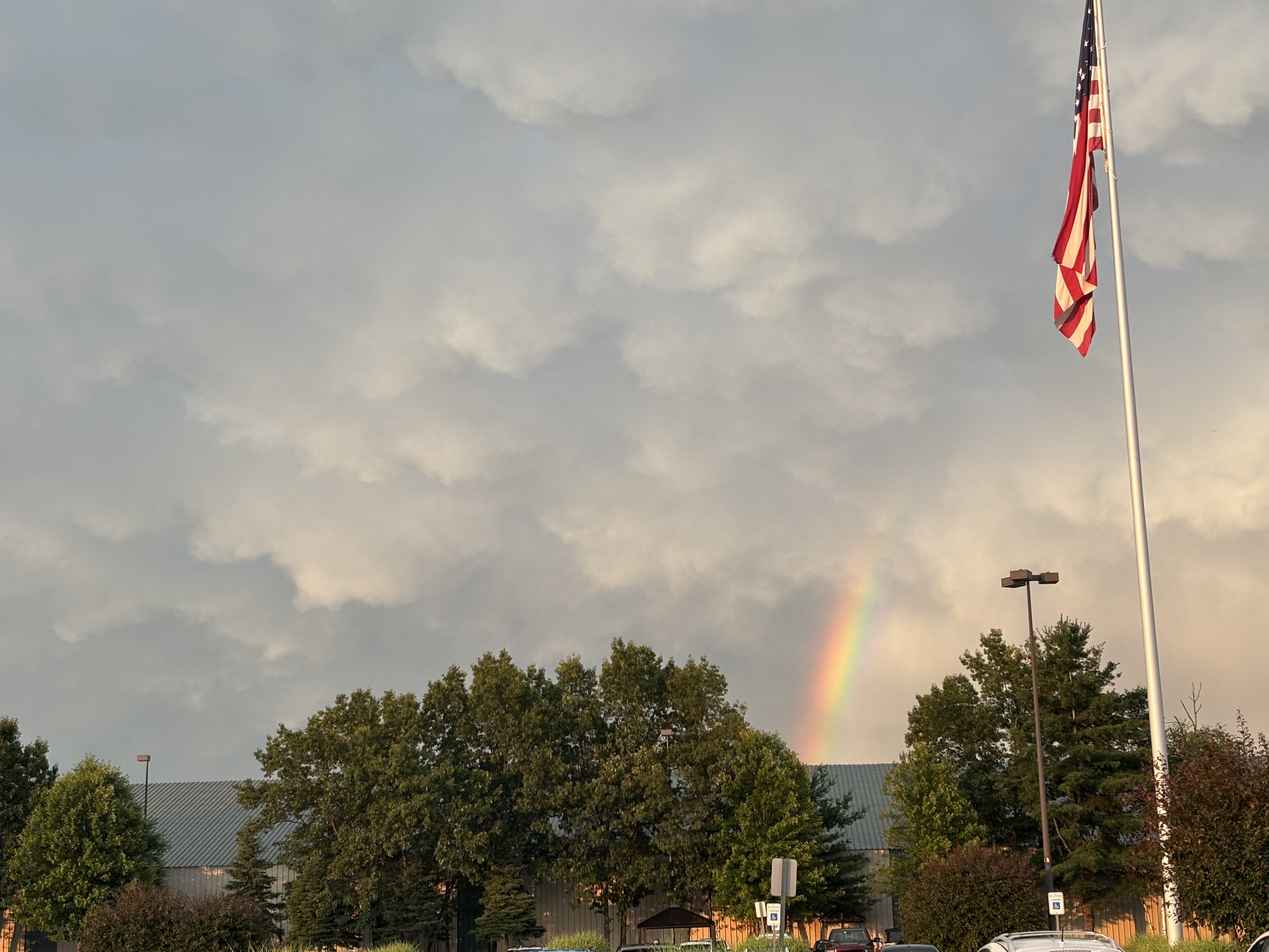
1 hour ago, weatherwiz said:
WOAH!!

Where'd you take that pic Paul? Great stuff!
-
1
-
 1
1
-
-
3 minutes ago, CoastalWx said:
Yeah was looking at that. Seems like it could have potential.
Could see a marginal risk kind of day with NW flow bringing golf balls to the Seacoast.
-
1
-
-
Thursday could be interesting if we can bump dew points up a bit. Cold temps aloft, decent lapse rates, and strong mid level flow. Worth watching.
-
1
-
 1
1
-
-
25 minutes ago, radarman said:
Is the rrfs available online so we can see how it does with convection?
The 3km is hit or miss to say the least but the hrrr is borderline unusable IMO, at least around here
The RRFS is on weatherbell for sure. It does OK from what I can see.
My bigger question is how it does in the cold season - cold air damming, mesoscale banding, etc.
-
Just now, Typhoon Tip said:
Why would their data dissemination not match what they are saying verbally - I'm likely legit, sure but it's still interesting.
Because the METARs only report a 6 hour max every 6 hours and the 1-min obs are rounded to the nearest degree C so unless they actually dial in manually we don't know for sure.
If they provided 1-minute data that wasn't rounded we'd know sooner.
-
1
-
-
15 minutes ago, weathafella said:
Not yet. 3pm still 100
NWS told us it was 101 when they dialed in shortly before 3.
-
101 Logan
-
4
-
-
Shoreline Scorcher

-
1
-
-
11 minutes ago, Damage In Tolland said:
So is the MCS on or off ?
Congrats Maine.
-
7 minutes ago, WxWatcher007 said:
The only time I can find BDL hitting 100° in June is 6/30/64. Would be impressive if it happens next week.
They were last at 100F in 2019. They reached 103F in 2011.
-
1
-
-
12 minutes ago, CoastalWx said:
Finally getting decent rain. But won't be much.
Thursday is your classic Albany to VT and NH day. Down to western MA and NW CT perhaps too. Rest of us are watching anvil canopies.
Yeah. Looks like a big day points N & W.
-
2
-
-
Thursday's severe threat seems decent especially near/west of I-91.
Mid-level lapse rates are fairly steep plus decent low and deep layer shear.
-
3
-
-
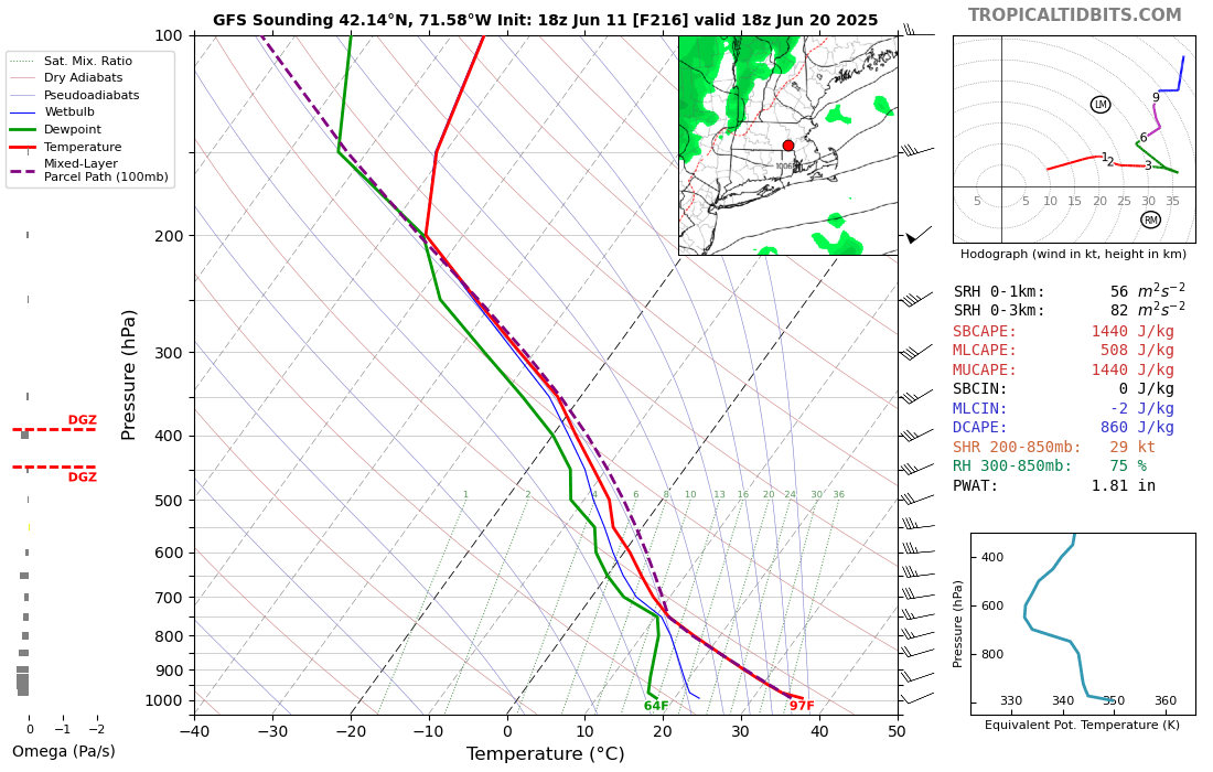
39 minutes ago, Torch Tiger said:
it was loaded af lol
you've been focusing on the dark side
lol this sounding is nothing special at all. Even assuming it's overmixed in the boundary layer you've got CAPE that's not impressive with meh mid-level rates. You also have 0-6km shear on the order of 25 knots or so which is not sufficient for organization/supercells.
Absolutely nothing like 6/20/95 or any of our more memorable events.

-
1
-
-
2 hours ago, Torch Tiger said:
CT Rain person said no severe, laughed at that assertion days ago
I didn't say no severe... just that sounding you posted didn't show anything of the sort.
-
1
-
 1
1
-
-
Aurora tonight?
-
2
-
-
1 hour ago, Torch Tiger said:
18z goes bonkers D9 - 6/20/95 anniversary btw. wish that could happen again
What's exciting about this?
-
1
-
 1
1
-
-
Lapse rates are pretty steep. Sucks there's not better mid level flow but we'll probably have some fun bangers around.
-
2
-
-
45 minutes ago, ineedsnow said:
12z CMC also cooled way down for next week
Yeah didn't like seeing that on the GGEM. GEFS still look OK though.
-
1
-
-
EPS, GEPS, and Ukie a total disaster Sunday through Wednesday. Lock it in
-
1
-
1
-
1
-
-
Wiz - are we locking in the D6/D7 EML on the GFS?
-
Updated this for the 11pm news tonight.
-
1
-
-
HRRR is really impressive for many. The NAM has been warmer with a stubborn layer around 850. We'll see!
-
3
-


July 2025 Obs/Disco ... possible historic month for heat
in New England
Posted
00z NAM washes away southern ORH county tomorrow AM.