

CT Rain
-
Posts
25,962 -
Joined
-
Last visited
Content Type
Profiles
Blogs
Forums
American Weather
Media Demo
Store
Gallery
Posts posted by CT Rain
-
-
Just now, ORH_wxman said:
03z RPM also coming in a bit west of the 00z run.
The HREF chucked big time too. Some really epic totals even back to C CT.
-
-
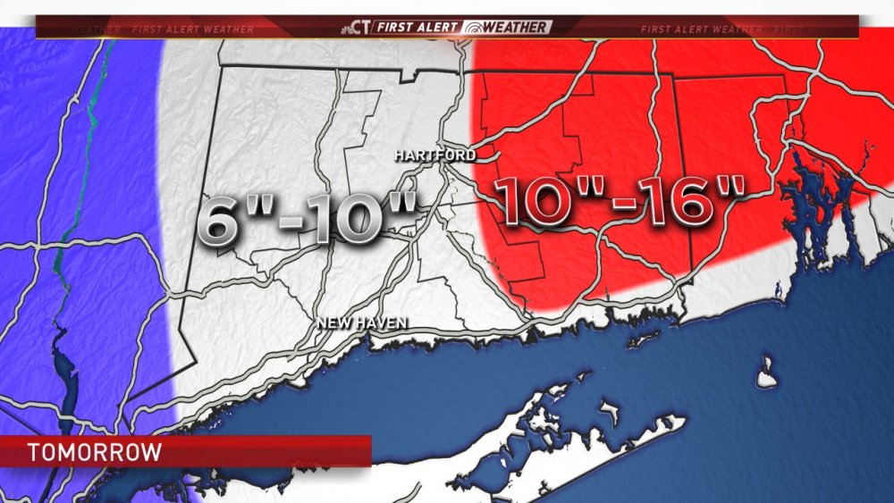
Update from my earlier 6"-12" map
-
 3
3
-
 1
1
-
-
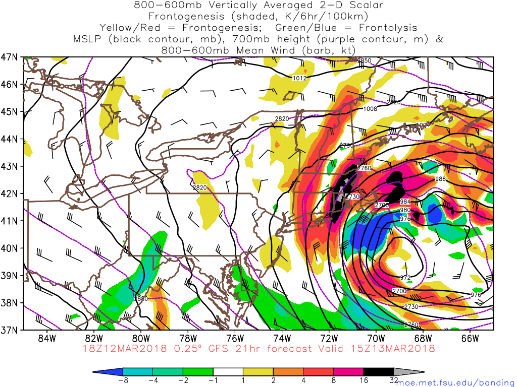
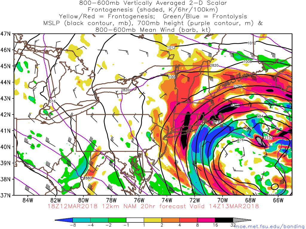
While the 12km run really went nuts - not much change from 18z to 00z on the 3km run.
-
The NAM brings a 700mb low over UUU or something weird.
-
FFS
Like 2" of liquid in E CT
-
-
33 minutes ago, weatherwiz said:
hmmm...I took screen shots of what I was looking at. Maybe I misinterpret the SGZ on bufkit (I still don't know if I fully understand the purple and yellow contours...even though people have told me...I just forget...need to write it down).
But what I interpreted was how the SGZ seemed to decrease (slope down to the left) that this meant the SGZ was lowering below the desired height (12K-18K). -15C intersects which is great and plenty of RH within the zone...what I meant by dry was just the look on the skew-t's...though GFS seemed fully saturated.


Wiz - the red lines are omega and the purple/yellow lines are for -10 to -20c and -12c to -18c, respectively. As the temperature profile changes those lines will move up or down. We care about -12c to -18c... it doesn't matter what height those are above the ground (doesn't matter if it's 6,000 feet up to 18,000 feet up if it's moist and you have vertical motion).
-
Just now, dendrite said:
Oh trust me...I know. Those pics are insane. I think Don S had some good ones on his site too.
Kevin would have slantsticked 48" while the valley got the real 4 footer.
-
 2
2
-
-
4 minutes ago, weatherwiz said:
This whole setup...well not necessairly the setup but looking over the data there is much much that stands out at being rather odd. Obviously, the NAM frontogenesis maps suggest we see some heavy/intense banding across a good portion of CT...but you look at NAM bufkit soundings across CT and outside of IJD these profiles don't seem very impressive too me. Omega within the SGZ at BDL and WTBY are crap...and the SGZ really just flops as we near noon. OTOH, GFS bufkit at IJD screams major subsidence across eastern CT and llvl subsidence further west with not much going on in the SGZ. This will disappoint many in CT (outside of who gets under the band).
Not to mention I still think this whole system away from the storm's center is nothing but banded precip
Hey Wiz - are you sure you're looking at this coming storm? Just looking at the 18z GFS and NAM and both look very juicy across the state with deep DGZs and nice omega intersecting it.
-
1 minute ago, dendrite said:
That was measured by great great great grandpa Wood.
lol having seen the pictures in Hartford and New Haven it definitely looked like a good 40-55 inches.
-
14 minutes ago, CoastalWx said:
Yeah Ryan. CT will get it good. Runaway rejoice. As usual these bands set up west.
I actually worry it's west of me even lol
-
-
1 minute ago, Damage In Tolland said:
Wouldn’t be an official storm until you made this troll post and then it never happens. Glad we don’t live in the valley
Eh, I'll be fine.
-
1
-
-
1 minute ago, wx2fish said:
Keep that south please. I think initially the best forcing will be NW and we may struggle a bit until the CCB materializes. Then we hope it clips E NH.
Tolland needs to be worried about that.
-
2 minutes ago, sbos_wx said:
I was TRIGGERED
Deal with it.
-Cosgrove
-
1
-
-
I actually think there could be an area of disappointment for a lot of SNE.
Max band will be right along the coast or near coastal front near Boston and down through the South Shore. Best low level warm advection etc. Probably the jackpot zone.
Second area is pretty far west with some nice 500-700hpa frontogenesis. In between I could see a bit of a sucker hole.
-
1
-
-
Just now, Typhoon Tip said:
I agree with Scott and Ryan in principle... How many times do you see a low pressure node some 400 naut mi E of Cape Cod with 12" deformation band producing snow and wind/vis issues over eastern NE...
That's really pushing the tin there...
Having said that, I am also wondering/leaving options the other direction equally, as consideration. Models could also have been erroneously opting to a convective induced center(s) too prodigiously and we could also see that low correct more W in tight - as in 24 hours lead.
The Euro and UKmet coming west ... I don't see any guarantee they won't do so again this cycle this morning. So... I'm bearing things in mind that it may be an omen either direction actually - not just for less..
One thing is that there's decent synoptic support well west with this thing so we are going to see good snows away from the center. For far eastern areas too the H7 low is very spread out so the best forcing is well NW.
That said - it's hard to get a widespread 1-2 feet with the storm fairly far offshore.
-
1 minute ago, CoastalWx said:
I just have this nagging feeling in the back of my head. But, I can afford to wait until 12z stuff rolls in to add confidence. Just not sold a wide area of 12-18+ like some have.
Yeah me too for some reason. The surface low is so far east with this one - it's not a classic look.
-
2
-
-
Just now, CoastalWx said:
Yeah you can see that at hr 39. Nice extension NW if that srn stream vorticty.
Crush. Job.
-
2
-
-
This thread is a total triple bunner.

-
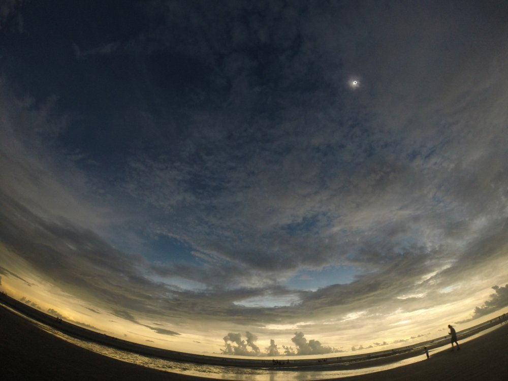
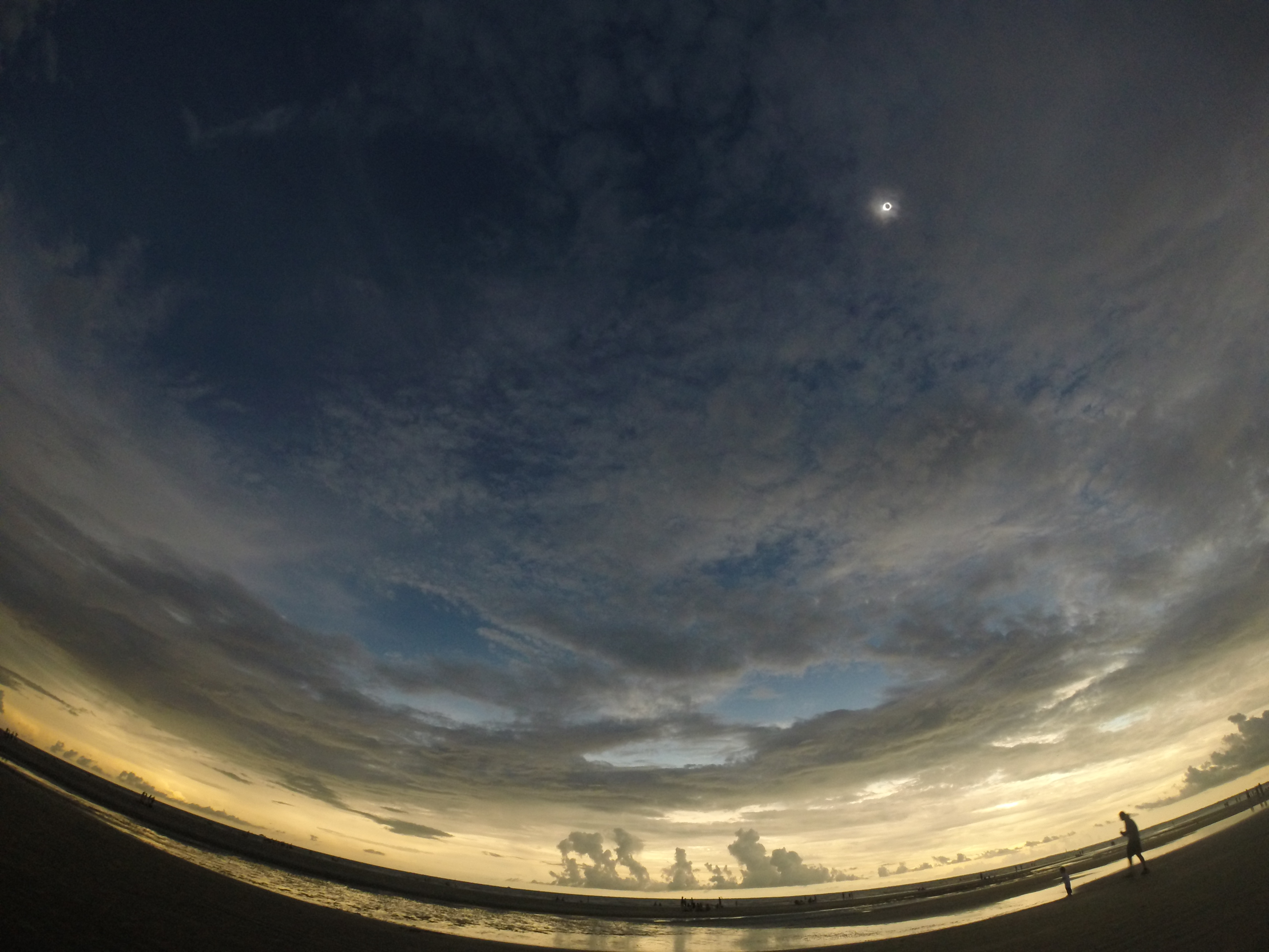
I just saw this thread. I was in Sullivan's Island, SC and the experience was beyond incredible.
I blogged about it here ---> http://www.nbcconnecticut.com/weather/stories/Solar-Eclipse-2017---What-an-Incredible-Experience-441577713.html
Glad to see so many others had a great time. Onto 2024!
-
1
-
-
2 hours ago, Ginx snewx said:
At this rate I may never need to install. Lol Euro and EPS
I love how Kevin installed in March lol
-
Just now, Typhoon Tip said:
oh i think it's likely evolve but that 12z oper. ...i'm just wondering if that tendency to over-evolve trough over the east isn't rearing it's head here.
Yeah probably overdone but either way another period of crap wx.


March 13th ... west Atlantic bombogenesis type low clipping SE New England, more certain ...may be expanding inland
in New England
Posted
Yeah I guess. I mean have to nod to the mesoscale models so close in. I like the 12z euro TBH... thinking like 12:1 for ratios too?