

CT Rain
-
Posts
25,962 -
Joined
-
Last visited
Content Type
Profiles
Blogs
Forums
American Weather
Media Demo
Store
Gallery
Posts posted by CT Rain
-
-
1 hour ago, CoastalWx said:
In all seriousness, Boston is going to have a massive * this season. They have observing issues.
Hopefully it was just a one time thing
-
Snowing pretty good here
-
Close for far NW CT too. Maybe even some ZR?
-
1 hour ago, CoastalWx said:
Yeah that was impressive. The interesting thing about CT is that you can do ok with a NE wind at times since it’s not a true water component. Seems like it happens more often than not, west of HVN. I always found that really cool.
Yeah a NE wind is good for HVN. Once you start going more ENE you pork SE CT as some milder air starts to come in with that easterly component.
-
 1
1
-
-
12 minutes ago, CoastalWx said:
As impressive as this was, Veterans Day ‘87 brought a foot to Plymouth. November’s of yore for Diane.
Son of Sandy too was a foot down in parts of coastal CT
-
1
-
-
Just now, ice1972 said:
Oh today? I’m going with 6” but the Pings started before I got out there so maybe it was a bit more? I mean I’m less than 2 miles from the station so.....what did you guys get over there?
I measured 8.0" actually. Had 1.00" of liquid in there too but there was some freezing rain and sleet on top.
-
1 minute ago, ice1972 said:
Precip shut off quickly enough that the pack didn’t get tainted too much....just enough to lock in.....gonna need to follow this up though to get the pack going....I’m looking to best my all time of 30” late Jan 2011.....great start
How much did you get?
-
1 minute ago, Ginx snewx said:
Ok
The winds are really picking up though. BDR gusted to 37 knots.
-
Just now, Ginx snewx said:
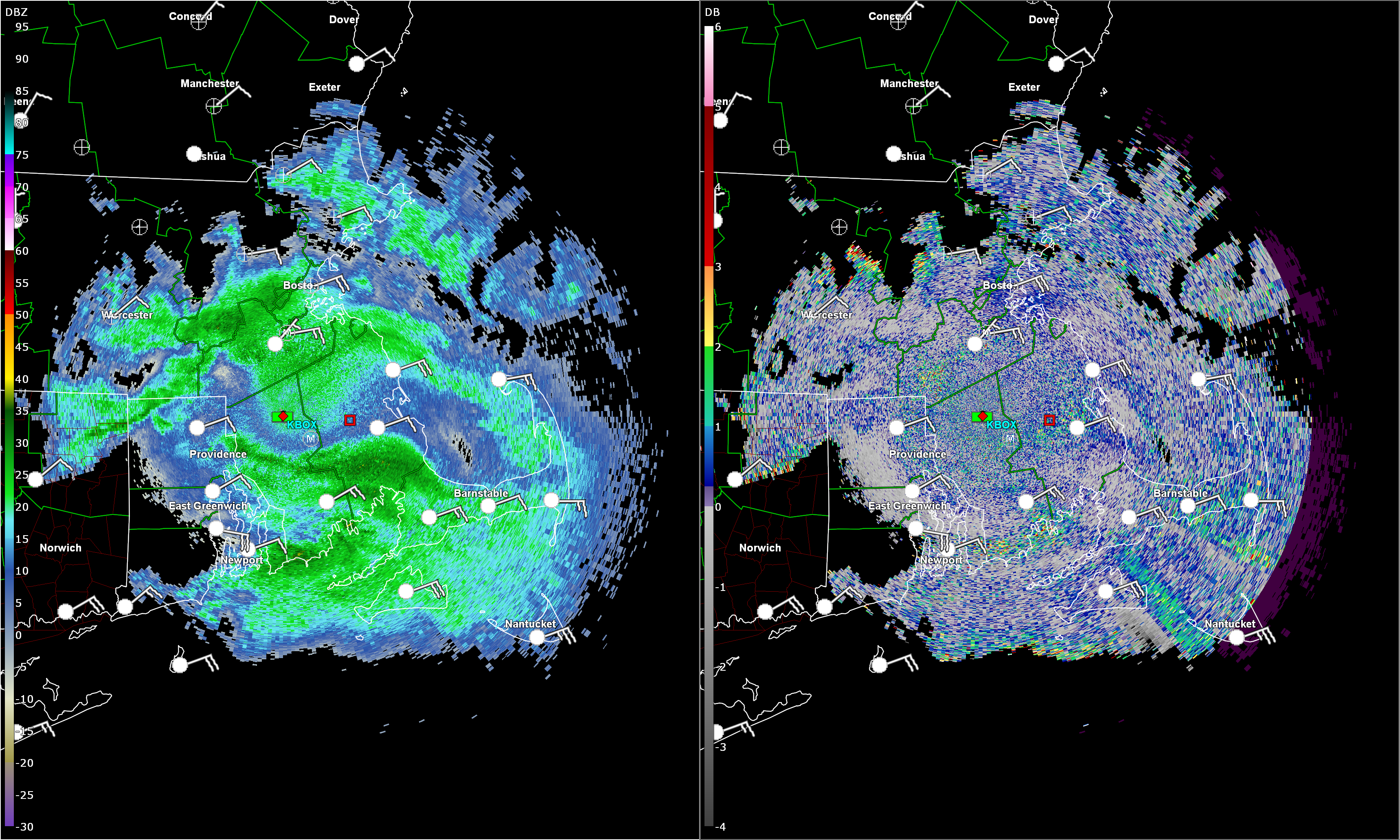
@CT Rain what the hell was this. I know the LLJ came roaring in but thus was crazy. Lightning in West Greenwich at the same time. Leaves everywhere now.

Looks like some bad data to me
-
Some depolarization streaks over SE Mass... so probably a bit of thunder somewhere.

-
1
-
-
Just now, ORH_wxman said:
The airmass was over performing all day too...so that also could have been a clue to anyone still really gun shy.
ORH not only set their record low max for the date...it was the coldest max temp on record pre-11/20. The most impressive part of it, is it was achieved without precip falling.
MOS busted big last night because of the cirrus shield... but NAM and GFS MOS were printing out 11F for BDL. So the air mass was pretty sweet.
-
Just now, Ginx snewx said:
Great job dude. Exceptional coverage. What a friggin disaster, people don't listen carefully
I mean didn't help that some of the other stations in the market had 1"-3" for Hartford right before the first flakes fell.
There were a few things that jumped out at me.
1) The air mass was *really* anomalous out ahead of this thing. Looks like BDL tied their record low max temp. A 1040 hpa high really primed us.
2) The synoptics and mesoscale ingredients were there for a really nasty thump and at least .2 or 3 hours of really good rates. The NAM, RGEM, ECMWF all were pretty cold for at least a good chunk of the thump.
3) the WPC snow probabilities were beyond atrocious I have no idea wtf was going on with those.
-
There were some really *awful* forecasts for this storm and I'm not sure why. Outside of some of the coastal areas it wasn't too tough compared to some of them.
-
1
-
-
8.0" here with 1.00" of liquid. I imagine we were closer to 9" before compaction but oh well - couldn't get home in time.
-
Here come the pingers
-
Updated call.
-
1
-
-
3 minutes ago, ORH_wxman said:
Hellacious thump before then...but I'd def keep it a little under the 6-8 over interior...prob more like 4-7 with maybe lolli to 8.
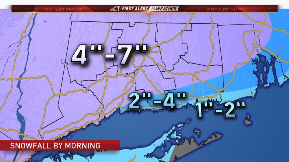
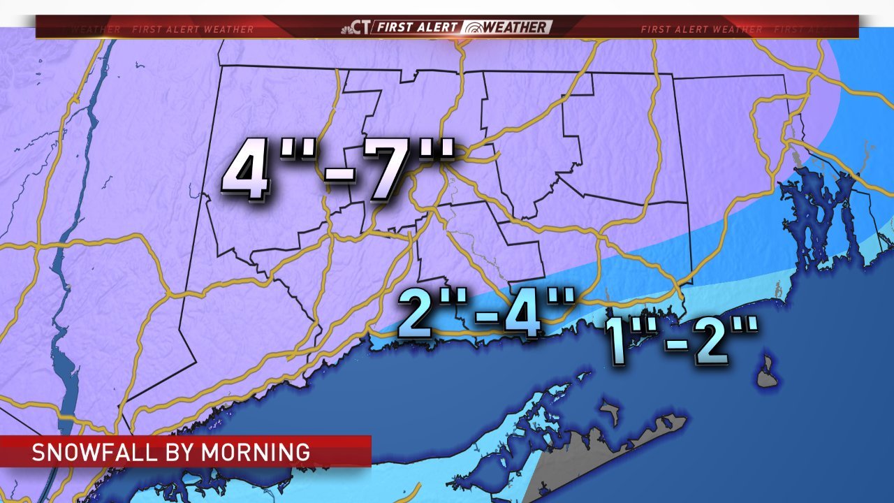
I'm thinking 4-7 most of CT.
-
Just now, CoastalWx said:
I think the algorithm needs help. NYC is not getting 10".
When you read about how these algorithms work for models like the NAM and GFS you realized how effed they are. Pretty much sell all clown maps.
-
2
-
-
Just now, 40/70 Benchmark said:
I hedged towards more sleet and some frz rain for your area with 2-4"....bit of a gamble, but we'll see.
Not sure there would be more here than areas north and east.
Seems like the omega thump is really maximized to the southwest.
-
2
-
-
I feel pretty good about 3-6" statewide here - except for SE CT.
Pretty epic omega thump coming in which should get stuff done. Like Will said though, wouldn't take much to get 7 or 8 in some areas.
-
2
-
 2
2
-
-
GFS still doesn't like bringing the stuff north. All about the follow up wave.
-
1 minute ago, dendrite said:
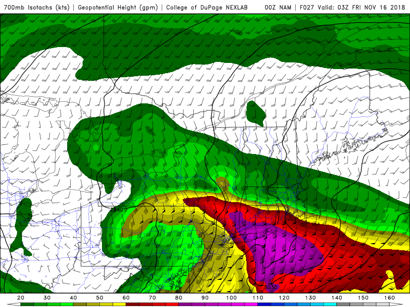
No omega in that image, but you can imagine the upglide over the cold dome where those H7 winds come to a screeching halt.
An atmospheric pig pile. Just like Kevin likes.
-
Going to be a hellacious thump.
-
4 minutes ago, ORH_wxman said:
I'm getting some 12/16/07 vibe on this with the high position and very intense omega...there's obviously some differences....the high is just a hair east of where the 07 version was and the low level cold isn't quite as intense but on the flip side the midlevel jet isn't as strong.
Still, it's a similar feel where the marginal thump solutions were holding firm or even slightly ticking colder until game time and it's tied to that fresh Arctic high in Maine. I'll feel more confident about warning snow possibilities if we can get through the 00z runs without any major changes.
I'm surprise people are so conservative here in CT. Obviously no BL issues and mid levels are looking colder.

December Discussion
in New England
Posted
I was going to say. Epic scooter sh*t streak over QC/NB by 12z Monday on the GFS.