

yoda
-
Posts
59,574 -
Joined
Content Type
Profiles
Blogs
Forums
American Weather
Media Demo
Store
Gallery
Posts posted by yoda
-
-
7 minutes ago, TSSN+ said:
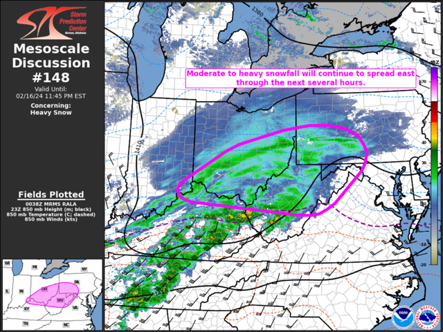
Mesoscale Discussion 0148
   NWS Storm Prediction Center Norman OK
   0640 PM CST Fri Feb 16 2024

   Areas affected...The Upper Ohio River Valley into the central
   Appalachians

   Concerning...Heavy snow

   Valid 170040Z - 170445Z

   SUMMARY...A swath of moderate to heavy snow is expected to spread
   east across the upper Ohio River Valley into the central
   Appalachians through the evening hours.

   DISCUSSION...Over the past several hours, a semi-persistent band of
   moderate to heavy snow has shifted east across the Midwest and
   middle OH River Valley. Surface observations and web cams under this
   band have shown visibility reductions down to 1/4 mile at times,
   indicative of moderate to heavy snowfall rates. Snowfall reports
   over the past 1-3 hours support this idea with multiple reports of
   3-5 inch snowfall totals since early afternoon. Recent upper-air
   analyses continue to show favorable overlap of broad synoptic ascent
   ahead of the approaching low-amplitude upper wave with a more
   focused zone of mesoscale ascent driven by a plume of warm advection
   and frontogenesis within the 925-850 mb layer. Favorable phasing of
   these mechanisms is expected to persist for the next several as the
   synoptic system shifts east towards the Mid-Atlantic.

   Consequently, organized snow bands capable of heavy snowfall rates
   upwards of 1-2 inch/hour will remain possible across the upper OH
   River Valley into the central Appalachian region for the next
   several hours. Locations downstream that are currently not below
   freezing may see a slightly delayed onset of snowfall as low-level
   saturation promotes temperature reductions below freezing.
   Furthermore, orographic ascent within the Appalachians may augment
   lift over eastern WV/western VA and increase the potential for 2+
   inch/hour snowfall rates during the 04-06 UTC period.

   ..Moore.. 02/17/2024

   ...Please see www.spc.noaa.gov for graphic product...

   ATTN...WFO...CTP...LWX...RNK...PBZ...RLX...CLE...JKL...ILN...
   LMK...
-
 2
2
-
 2
2
-
-
3 minutes ago, WxMan1 said:
00Z Euro, 10-1

Zoomed in close up
")

-
5
-
-
@Deck Pic slightly drier 00z Euro QPF looks like? Noise I assume
-
00z UKIE FWIW

-
2
-
-
Pivotal 10:1 says Wes wins

-
2
-
 1
1
-
-
We definitely love the GFS tonight
-
1
-
-
Just now, DDweatherman said:
Getting lower, the new thread will be here by 12z maybe?
The new thread will be the obs thread
-
1
-
 1
1
-
-
6 minutes ago, Deck Pic said:
hell yeah it is. It's probably overdone. But not by much.
Great, now all I can think is Pirates of the Carribean...
Hoist the colours!
-
I do like the bolded though
Special Weather Statement
National Weather Service Baltimore MD/Washington DC
907 PM EST Thu Feb 15 2024

DCZ001-MDZ003>006-008-011-013-014-016>018-502>508-VAZ025>031-
036>040-050-051-053>057-501-502-505-506-508-526-527-WVZ051>053-
161100-
District of Columbia-Washington-Frederick MD-Carroll-
Northern Baltimore-Cecil-Southern Baltimore-Prince Georges-
Anne Arundel-Charles-St. Marys-Calvert-
Central and Eastern Allegany-Northwest Montgomery-
Central and Southeast Montgomery-Northwest Howard-
Central and Southeast Howard-Northwest Harford-Southeast Harford-
Augusta-Rockingham-Shenandoah-Frederick VA-Page-Warren-Clarke-
Nelson-Albemarle-Greene-Madison-Rappahannock-Orange-Culpeper-
Fairfax-Arlington/Falls Church/Alexandria-Stafford-Spotsylvania-
King George-Northern Fauquier-Southern Fauquier-Western Loudoun-
Eastern Loudoun-Central Virginia Blue Ridge-
Northwest Prince William-
Central and Southeast Prince William/Manassas/Manassas Park-
Morgan-Berkeley-Jefferson-
Including the cities of Washington, Hagerstown, Frederick,
Ballenger Creek, Eldersburg, Westminster, Reisterstown,
Cockeysville, Elkton, Baltimore, Bowie, Suitland-Silver Hill,
Clinton, College Park, Greenbelt, Laurel, Camp Springs,
Glen Burnie, Annapolis, Severn, South Gate, Severna Park, Arnold,
Odenton, St. Charles, Waldorf, Lexington Park, California,
Chesapeake Beach, Huntingtown, Dunkirk, North Beach, Lusby,
Prince Frederick, Cumberland, Germantown, Damascus, Bethesda,
Rockville, Gaithersburg, Silver Spring, Lisbon, Columbia,
Ellicott City, Jarrettsville, Aberdeen, Staunton, Waynesboro,
Stuarts Draft, Harrisonburg, Strasburg, Woodstock, Mount Jackson,
New Market, Winchester, Luray, Shenandoah, Stanley, Front Royal,
Berryville, Lovingston, Charlottesville, Stanardsville, Madison,
Orange, Gordonsville, Culpeper, Reston, Herndon, Annandale,
Centreville, Chantilly, McLean, Franconia, Arlington, Alexandria,
Falls Church, Falmouth, Fredericksburg, Dahlgren, Warrenton,
Turnbull, Purcellville, Leesburg, Ashburn, Sterling, Wintergreen,
Haymarket, Dale City, Manassas, Woodbridge, Lake Ridge,
Montclair, Paw Paw, Martinsburg, Charles Town, and Shepherdstown
907 PM EST Thu Feb 15 2024

...ACCUMULATING SNOW POSSIBLE FRIDAY NIGHT...

Snow will overspread the area from west to east Friday evening and
exit Saturday morning. Generally one to three inches of snow is
expected at this time. Localized totals upwards of four to six
inches are possible wherever the bands of snow set up. Snowfall
rates of one to two inches per hour are possible in these bands.

Plan on slippery road conditions. The hazardous conditions could
impact travel Friday night into Saturday morning.
-
2
-
1
-
1
-
-
2 minutes ago, Deck Pic said:
Here's the 1.33k at 36 hours - not sure how skilled it is toward the end of the run.. It precips lightly after this. But 90%+ over.

Is that 0.50 QPF in DC metro? I'm trying to differentiate the colors
-
1 hour ago, Terpeast said:
They’ll probably replace it with a new headline. Not sure why they hoisted a special weather statement in the first place, especially seeing that they hoisted a WSW soon after
They replaced it with another SPS
-
1
-
-
18z Euro is just about at its money frame...
-
5 minutes ago, jaydreb said:
Still a special weather statement in the immediate suburbs.
Probably going WWA shortly
-
1 minute ago, stormtracker said:
I gotta find my map where I parodied his maps. I think I posted it last year
The erh map is the best ever
-
10:1 snow map FWIW on 18z RGEM

-
18z RGEM is a i66 special going by qpf field

-
1
-
-
Afternoon AFD from LWX
Area Forecast Discussion...CORRECTED
National Weather Service Baltimore MD/Washington DC
217 PM EST Thu Feb 15 2024

...

.SHORT TERM /6 AM FRIDAY MORNING THROUGH SATURDAY NIGHT/...
Very brief high pressure quickly traverses the area on Friday,
bringing dry conditions for the daytime hours. Highs expected to
reach the 30s in the Alleghenies, and 40s to low 50s elsewhere.

A fast moving clipper system is forecast to track along or near the
I-64 corridor in the southern 1/3rd of the CWA Friday tonight into
Saturday morning. This system is going to bring widespread snow to
most of the forecast area, with rain likely in areas south of the
low`s track. The 12Z guidance continues to trend upwards with QPF and
forecast snow amounts, with favorable dynamics for banding and high
snow rates. Temps aloft are expected to be cold to support snow
throughout the event. The highest snow amounts are likely in the
Alleghenies and where any banding features develop (which at this
point is difficult to pin down). In the Alleghenies, forecast snow
amounts of 4-6" with isolated higher amounts up to 8" possible.
Elsewhere, forecast snow amounts of 1-3" with isolated higher amounts
of 4-5" possible. The Blue Ridge could see 2-5" of snow. Again, those
higher end amounts are going to depend on where snow bands set up.

The Winter Weather Watches remain for the Alleghenies and parts of
the Potomac Highlands where confidence is high for 4-6" of snow.
Winter Weather Advisories will likely be issued for most of the rest
of the area tonight, as that will be around 24 hours before snow
falls late Friday night. Stay tuned to the latest updates at
weather.gov/lwx/winter.

Precipitation ends from west to east Saturday morning, with any
lingering light snow east of I-95 ending by late morning. Mountain
snow showers continue through the afternoon. High pressure builds in
Saturday afternoon as dry conditions prevail. Temperatures quickly
rebound to the 30s to low 40s outside of the mountains, which should
allow a good/most of the snow on the ground to melt. Temperatures
Saturday night drop to 20s, with 10s for the mountains.
-
2pm update
-
2
-
1
-
-
2 minutes ago, Ji said:
why is my thing showing 6 inches

It's showing blue... so...
-
2 minutes ago, Solution Man said:
New thread....let's do it
I don't see the reason for it... but it's @Deck Pic thread then
-
2
-
-
5 minutes ago, yoda said:
Huh?

Above quoted is hr 42 at DCA sounding. Below is hr 48 sounding at DCA

-
Just now, Terpeast said:
With the qpf and soundings you just posted, their snowfall output is probably wrong
I mean that's DCA at 06z. Sounding is firmly below freezing at every level and 32 at surface... so I have no idea why rain is considered the best guess precip type. It has freezing rain at 48 hours as it's best guess precip type too. Very odd
-
Just now, Terpeast said:
Ukie qpf actually looks about in line with the other models
Yes but what's with the best guess precip type of rain?
-
The Weekend Rule? Saturday 2/17 - The Icon Storm
in Mid Atlantic
Posted