-
Posts
59,574 -
Joined
Content Type
Profiles
Blogs
Forums
American Weather
Media Demo
Store
Gallery
Posts posted by yoda
-
-
1 minute ago, Terpeast said:
Post it for everyone to see...


-
 2
2
-
-
Very odd 12z UKIE run... I think we can safely toss
-
-
 7
7
-
-
4 minutes ago, WxUSAF said:
Booooo…not the reveal I was looking for.
-
10 minutes ago, H2O said:
He meant to say it tastes like Miller Lite
10 minutes ago, stormtracker said:Winnah
Beer blows. I hate carbonation, well, more the way it tastes, so I don't drink any soda or beer whatsoever. If I'm having an alcoholic drink, it better be something like on the rocks espresso martini or some Grey goose
-
I feel for the Orioles fans this morning

https://www.mlbtraderumors.com/2024/02/orioles-kyle-bradish-ucl-sprain-elbow-injured-list.html
-
 3
3
-
-
Just now, H2O said:
He meant to say it tastes like Miller Lite

I don't drink beer at all
-
Just now, stormtracker said:
How does it taste? You say this all the time and I'm curious how the model tastes? Snozzberry?
Tastes like iced caramel macchiatto with extra caramel
-
 3
3
-
 1
1
-
-
42 looks tasty
-
I see Wes

-
 5
5
-
 2
2
-
-
1 minute ago, Chris78 said:
Damn. That's sexy AF
Equates to a bit less snowfall though compared to the 06z run

-
 1
1
-
-
Just now, yoda said:
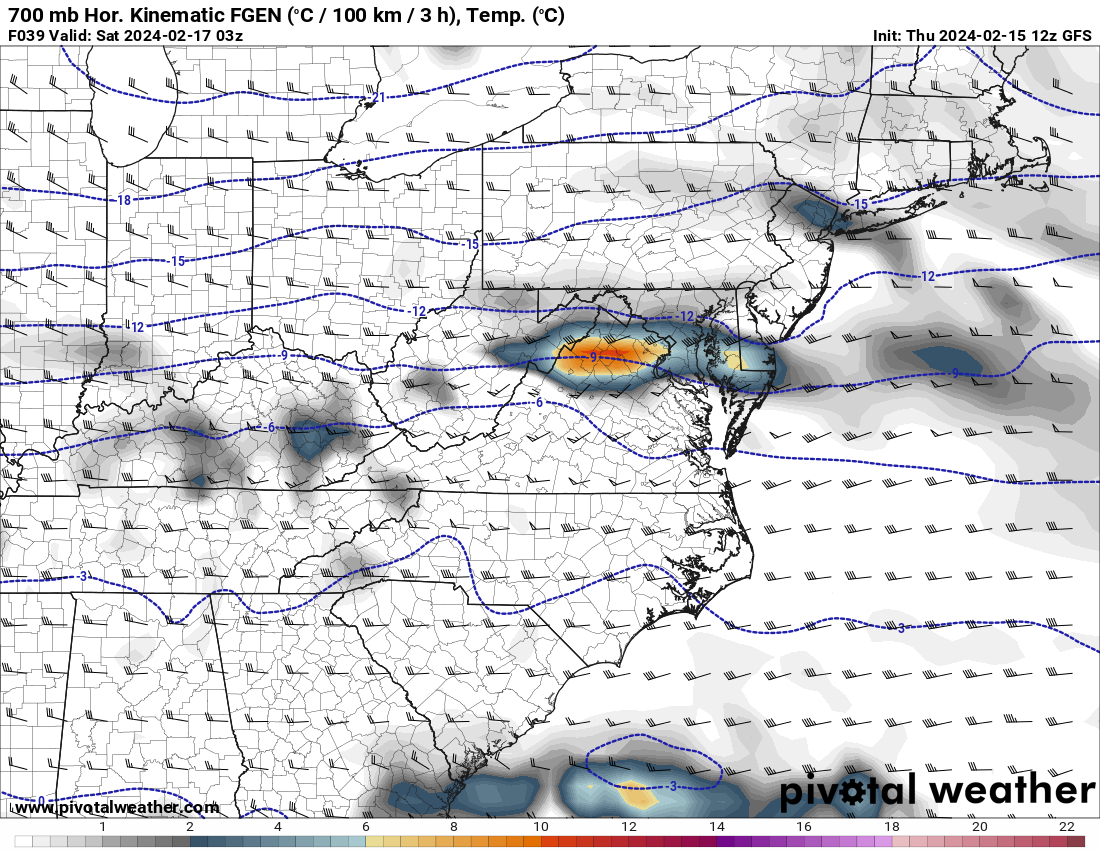
12z ICON has the two banding idea... one across M/D line other across i66 corridor... can see this on the qpf map

-
 2
2
-
 1
1
-
-
12z ICON has the two banding idea... one across M/D line other across i66 corridor... can see this on the qpf map
-
1 minute ago, Interstate said:
But like I said yesterday... you can see how the mountains kills the organized QPF.
LWX in their updated morning AFD disagrees (10am update)
SHORT TERM /6 AM FRIDAY MORNING THROUGH SATURDAY NIGHT/...
Brief high pressure builds in early Friday behind the exiting
clipper before a second clipper system approaches and passes to
the south and brings snow to the region.

Most of the guidance has the surface low tracking near the I-64
corridor toward the lower Chesapeake Bay, though there is still
some ensemble members that take a more northern track. The
latest 06Z guidance, and the early 12Z guidance is indicating an
uptick of QPF, particularly from Pendleton/Highland east toward
the Blue Ridge. Even though surface temps will be marginal,
around 29F-32F during the peak of the event, snow rates will be
high and there is a good signal for banding somewhere in the
area. As a result, have increased snow totals this morning to
4-6" in the Alleghenies, 3-5" in the Shenandoah Valley from
Rockingham County northward, 2-4" north of I-66 and east of
Blue Ridge, and 1-2"south of I-66 and east of Blue Ridge.
Winter Storm Watches have been issued for the Alleghenies and
portions of the Potomac Highlands. Additional Watches, Warnings,
and Advisories are likely to be issued later this afternoon.
Stay tuned for additional updates on snow totals as the latest
guidance comes in.
-
 6
6
-
 1
1
-
-
2 minutes ago, yoda said:
12z RGEM seems slower then the 12z NAM twins
DC metro jackpot though of 3"
-
12z RGEM seems slower then the 12z NAM twins
-
Oh... yes the favored areas to get the most and the such... but a bit of a surprise to see
URGENT - WINTER WEATHER MESSAGE
National Weather Service Baltimore MD/Washington DC
946 AM EST Thu Feb 15 2024

MDZ001-501-VAZ503-504-507-WVZ050-055-501>506-152300-
/O.NEW.KLWX.WS.A.0005.240217T0000Z-240217T1200Z/
Garrett-Extreme Western Allegany-Western Highland-
Eastern Highland-Northern Virginia Blue Ridge-Hampshire-Hardy-
Western Grant-Eastern Grant-Western Mineral-Eastern Mineral-
Western Pendleton-Eastern Pendleton-
946 AM EST Thu Feb 15 2024

...WINTER STORM WATCH IN EFFECT FROM FRIDAY EVENING THROUGH
SATURDAY MORNING...

* WHAT...Heavy snow possible. Total snow accumulations of 4 to 6
  inches are possible with localized amounts up to 8 inches
  possible along the higher western facing slopes of the Allegheny
  Front.

* WHERE...Portions of western Maryland, northwest and western
  Virginia and eastern West Virginia.

* WHEN...From Friday evening through Saturday morning.

* IMPACTS...Plan on slippery road conditions. The hazardous
  conditions could impact the evening commute.

PRECAUTIONARY/PREPAREDNESS ACTIONS...

Monitor the latest forecasts for updates on this situation.
-
4 minutes ago, stormtracker said:
What a night. Ok. Seems like things are status quo? My expectations are a 1-2 deal for the city. Think I’m good for it
My bar is 2". But yeah... 1-3 sounds good and let the chips fall where they may on anything more
-
Just now, aldie 22 said:
Euro seems to have the best stuff for my location around 2-3am...might be worth waking up for if it's coming in hot
You aren't just staying up Friday night?
-
 1
1
-
-
This seems like one of those rare systems that it comes in hot, rakes for like 4 to 6 hours, and then is gone, no?
-
 2
2
-
-
Tasty

ETA: the snowfall map i posterld is 10:1 SLR... snowfan's is the Kuchera
-
 5
5
-
-

6z euro total qpf for the event
-
 3
3
-
-
Just now, stormtracker said:
How the fuck are yalls map so different than SV. SV sucks
That's Kuchera... maybe you are 10:1?
-
12z UKIE FWIW

-
 3
3
-


The Weekend Rule? Saturday 2/17 - The Icon Storm
in Mid Atlantic
Posted
I edited it in just before you posted