Shenanagins1091
-
Posts
22 -
Joined
-
Last visited
Content Type
Profiles
Blogs
Forums
American Weather
Media Demo
Store
Gallery
Everything posted by Shenanagins1091
-
Got really lucky here in Gulf Shores that it went way east like the ICON and AI were showing. Hoping those east were able to prepare
-
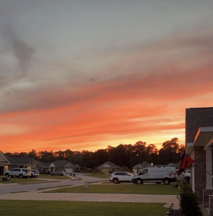
Great sunset in Gulf Shores AL tonight
-
January 25-26 Winter Storm Potential
Shenanagins1091 replied to Ralph Wiggum's topic in Philadelphia Region
GFS did such a great job with this one. Never showed the 18-24" solutions and did a better job with timing. Long live the king. Taking my 5-10" call victory lap that I locked in on Friday GG boys . -
January 25-26 Winter Storm Potential
Shenanagins1091 replied to Ralph Wiggum's topic in Philadelphia Region
5-10" feels like a decent call for south jersey given the mixing . -
It actually snowed 9.5" here and not the 6.5" they claim in OBA and Gulf Shores too just to blow your mind a little more

-
Final total from Gulf Shores, AL


-
8" in Gulf Shores AL. Didn't post a picture last time so here ya go lol. Still snowing

-
8" so far in Gulf Shores
-
Coming down good here in Gulf Shores

-
Sleet in Gulf Shores. Can't believe this is going to happen still lol
-
Mid to long range discussion- 2025
Shenanagins1091 replied to wncsnow's topic in Southeastern States
If it snows an actual measurable about here at the beaches of bama, I'm taking off work and having a drink sesh on the beach -
January Medium/Long Range: A snowy January ahead?
Shenanagins1091 replied to mappy's topic in Mid Atlantic
Can anyone ELI5 why the first system seems to just fall apart and then sort of magically redevelops slightly as it pulls away, and why the GFS has such a southern slider next week but the Euro doesn't? Just so curious, both look so weird on the models -
2024 Atlantic Hurricane Season
Shenanagins1091 replied to Stormchaserchuck1's topic in Tropical Headquarters
Another season in the books - hoping for some more stable weather soon to get in on the YFT bite -
2024 Atlantic Hurricane Season
Shenanagins1091 replied to Stormchaserchuck1's topic in Tropical Headquarters
Hurricane and typhoon numbers are decreasing, study finds, even as they become more destructive | CNN A very interesting read here -
I am not a big fan of people measuring a hurricane season based on dollars. Everything cost more every single year - houses, properties, cars, boats, etc, and then there is just simply more 'stuff' at the coast year over year. Not really surprising the financial cost increases. I live on the coast and I take our environmental concerns very seriously, but just do not like the idea that total cost of storms = worse hurricane season than XYZ year - if that makes sense.
-
Wasn't everyone complaining this was a weak nothin burger? Typical internet. Prayers for those in the area being affected
-
E PA/NJ/DE Winter 2023-2024 OBS/Discussion
Shenanagins1091 replied to The Iceman's topic in Philadelphia Region
I wonder where NWS gets the 6" comes from, even with kuchera ratio still haven't really seen more than 3-4.7" on any models. We shall see maybe they are onto something. 2-5" feels like such a solid call for everyone. -
E PA/NJ/DE Winter 2023-2024 OBS/Discussion
Shenanagins1091 replied to The Iceman's topic in Philadelphia Region
Been following along for weeks here, it's pretty cool how even in December we knew 1/5 to 1/22 would be a good period. I don't see the 4-6" happening as an amateur, none of the guidance really shows it unless you start nit picking around for stuff like the HRRR using kuchera ratio. 2-4" is such a solid bet for PHL S&E and maybe 3-5" N&W, ready to lock that in. -
Not sure why everyone hates the GFS. I stuck with the old gal and feel pretty good about what I told folks since it played out basically perfect per my expectations. Guys like WXrisk and EPAWA plus kuchera map weenies are to blame for pissing people off. This wouldn't be considered a bust if people weren't told to expect a foot or more when they got 8"
-
It played out as expected in most places like I said. Don't really care about CNJ, only really look at PA, SNJ and DE since those are where my friends and family are. Cannot really comment on CNJ sorry. I did tune into the local channels and alot of them just didn't really mention the mixing anywhere except the shore. There's a feel to weather forecasting, it's not all pretty maps. NWS erroneously called for up to 12" in spots in SNJ and all but guaranteed a foot at a minimum in alot of SE PA. Never bought in, didn't buy in to the storm that wasn't before Christmas either. People will never learn either!
-
Eh, my personal predictions of 5-10 Philly s&e and 7-14 n&w look great. I didn't hug the Euro and kuchera ratios like some did. Certain models always had the precip being mixed for lengthy periods of time right into PHL, but it did go a little bit further than inland than expected. It's only a bust if you hugged the wrong models and maps and ignored others.