msuwx
-
Posts
678 -
Joined
-
Last visited
Content Type
Profiles
Blogs
Forums
American Weather
Media Demo
Store
Gallery
Everything posted by msuwx
-
It’s weird to me how this board can be lit up like a Christmas tree analyzing the Day 8 NAVGEM, but now that a major storm is about to hit many, many people in the region, the post frequency tails off. Is it because the storm isn’t producing pure snow for many? Eastern NC getting the short end of the stick? To me, this is pretty easily the most significant winter storm, per capita, in a few years.
-
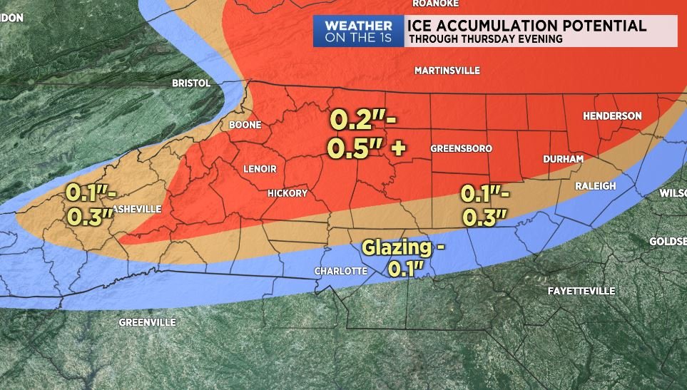
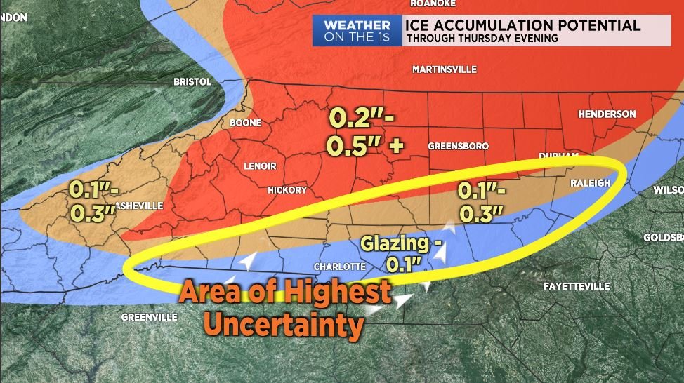
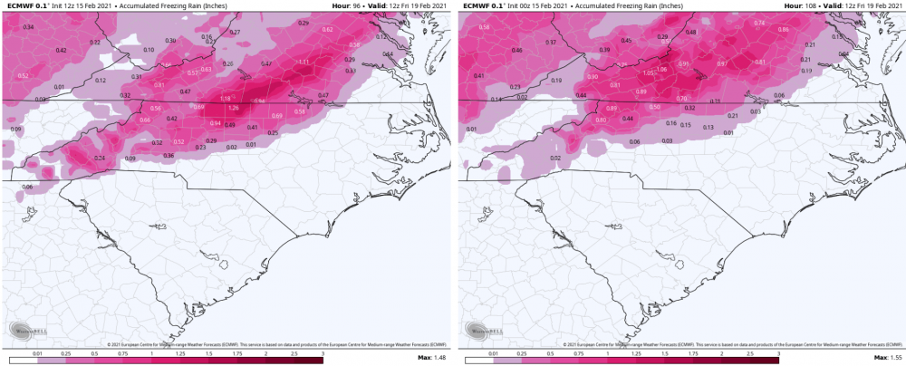
That is a big reason why you never achieve the maximum freezing rain depictions on modeling in reality. Much is lost to runoff and other factors. Freezing rain just simply cannot physically accrue at 100% of the QPF rate unless it is extremely light in general and temperatures are very cold.
-
Ha ha ha. I put some thoughts earlier today on Twitter and Facebook. My daughter had surgery today, so hopefully I will be more active tomorrow. good trends!
-
I’m such a nerd with CADs. I find them fascinating, and this is a textbook example being modeled right now. It’s fun to watch the atmospheric physics in motion. As things are currently depicted, it’s a case study setup for a western and central ( some portions) NC, western SC, and even northeast GA CAD winter storm For those that are unhappy with the trends, let the timing or intensity of the Northeast high get out of whack….then you get wailing and gnashing of teeth as many wind up with a 42° driving rainstorm.
-
No….70° + in winter is the worst.
-
Interestingly enough, the winter of 1999-2000 was one of my analog winters for my winter forecast, and I specifically referenced the old Carolina Crusher as a way of pulling out a big event even though a lot of the winter might be 'unfavorable.' Interesting.
-
Many NC locations, including the big cities, just finished about a 14 day stretch yesterday where every single high temperature was below average. Many days quite a bit below average. So while we missed out in the brutal arctic stuff, it has been far from warm.
-
Once the sun sets, the Earth emits outgoing longwave radiation. A layer of clouds blocks that outgoing longwave radiation, trapping the heat in. As the radiation continues, temperatures can actually warm a decent amount.
-
I’ve made no changes to my map from early this morning. Charlotte metro will struggle to get to and/ or stay below freezing.
-
I am leaving things status quo for now....but the warmer solutions are especially evident around the CLT metro.
-
The wet bulb map will be pretty useless until we see how much quick cooling we see early this evening before clouds thicken up.
-
As I mentioned earlier, the southward trend has definitely stabilized and even reversed in some instances. No changes to my earlier map. But gut says its going to be difficult to get the Hwy74 corridor below freezing for any real long length of time. We will see. **Edited to clarify Hwy 74 corridor Gastonia-CLT-Monroe**
-
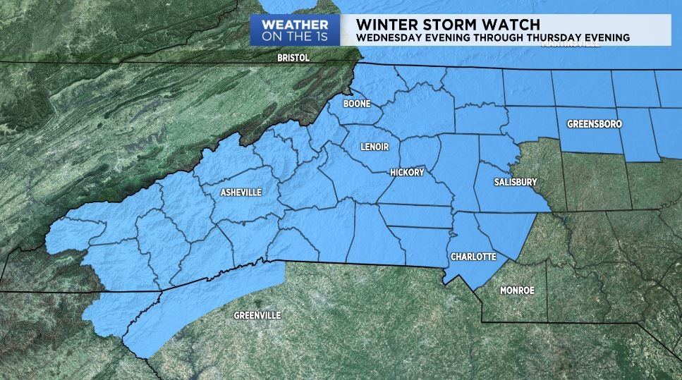
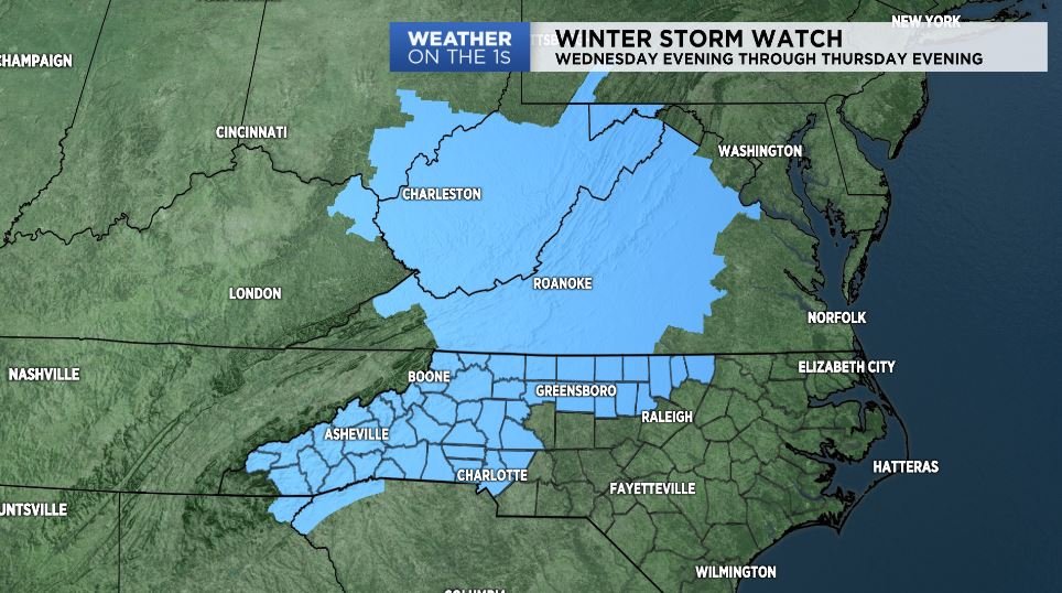
I posted this a couple hours ago... ”This is my map, prior to the mid-morning model guidance arriving. I reserve the right to adjust if necessary later today. As usual, the area of highest uncertainty is at the fringes of the sub-freezing air, which unfortunately includes the CLT and RDU metros. Those in the red-shaded area especially, be prepared for the potential of power outages. Once you start getting ice accumulations above 0.25", the power grid begins to experience failures.“

- 970 replies
-
- 14
-

-

-
Most of the 6z suite came in slightly warmer for Charlotte proper and the immediate metro. Or at least the colder/ southward trend seemed to stop. We shall see.
-
GSP will hoist some watches shortly. Now is the time with their afternoon forecast package.
-
-
It’s had its ups and downs. Did fairly well with convection. It was way too cold with the event a couple weekends ago. It was pretty good with the last weekend. Did well with the rate of clearing today.
-
Yeah it could be the GRAF. I’m not at a computer right now to check.
-
18z NAM it appears.
-
The big reason the 12z Euro is 'warmer' than the 0z for Tuesday is that the 500mb energy goes negative tilt over the central Gulf Coast, and the surface low matures and is much stronger, much sooner on the 12z compared to the 0z. The overall signal has not changed, and there are going to be tons of changes as the models resolve: - the depth of the cold, arctic air - the strength, orientation of individual short waves - the strength, placement of the CAD-inducing high - many other moving pieces. I strongly suggest folks to check their emotions with the wild swings that are sure to come.
-
While people have been complaining about cold being delayed over and over and over again this winter, we’ve had a consistently cool winter, zero blowtorches, a couple of minor events, and a mountain ski/ snow season that’s the best in several years. There are also consistently a couple of posters who have declared winter over multiple times and that no more flakes would fall at XYZ location. It gets tiresome. We have not scored a major snowstorm in a lot of places for quite a while, and I get it and feel the frustration as well. But the whining about this winter is completely unjustified to this point. I am on two hours sleep and a little punchy, so forgive me. Ha ha
-
Regarding the airplane obs, it's a significant issue and was extremely noticeable in the earlier stages of the pandemic when there were even fewer planes in the air. I expect the trends toward a wetter solution this weekend to continue. The question is how much phasing/ cold air is available for non-mountain NC areas. To be determined. I still like the looks of the pattern for next week.
-
Don’t forget that surface pressures are a result of the strength and placement of upper level features and forcing. If those are modeled incorrectly, the surface pressures will not be correctly modeled. So the idea of some feature in the future either being able or not able to do something because of modeled high pressure strengths and locations is a bit of an inaccuracy.
-
Bottom line seems to be this..... the active storm track will continue, and there will be lots of cold air involved in the pattern across eastern North America. For the Carolinas/ Virginia, there seems to be 3 impulses to monitor in the active storm track. 1) Late Saturday/ early Sunday 2) Tuesday-ish (that was the big storm on the Euro on yesterday's runs) 3) Late next work week. I fully believe any of those are fair game to amplify in the 'right' way to give some on this forum some fun and games. All of them probably won't, but any of the 3 are possibilities. And this is the classic case of it probably taking til the 11th hour to get the right idea as to the amount of interaction/ phasing each one will have.