MD Snow
-
Posts
1,875 -
Joined
-
Last visited
Content Type
Profiles
Blogs
Forums
American Weather
Media Demo
Store
Gallery
Everything posted by MD Snow
-
We take...
-
Wow...never did I think I would see the day when @psuhoffman would be extrapolating the 384 op GFS. We have arrived folks.
-
Kind of far fetched seeing as it's the op but 18z does bring back winter by next Wednesday and keeps it around throughout the run. Not much in terms of snow but plenty of cold. Let's see if the GEFS holds again.
-
Yup. I made a post in the middle of December about how we all put too much stock in long range ensembles etc. It blows me away how often we have had an amazing pattern in the long range days 10-15 and everyone is talking it up only to see it completely disappear. It goes both ways. And then everyone tries to explain why it disappeared only to see their reasoning for it disappearing have nothing to do with why it really disappeared. To punt the whole month of January is utterly ridiculous. I know it takes a while for crap patterns/jets to break down but still. I mean come on. How short our memories are. How often have we seen an ensemble completely screw up within 7 days with a storm just disappearing? How often have we seen 100's+ mile shifts within 96 hrs? And here we are making blanket statements about a whole month...blows my mind every. single. year. I would simply argue this...long range forecasting tools are great. Let's learn them. Let's learn how to use them. But in a way we kind of have to let the weather just happen and not take anything to seriously outside of say 10 days. We need to realize that yes there's a chance the whole winter will suck. That happens every once in a while but it's still a pretty low probability with 2.5 months of chances left. However, at this point in the winter, there is still a very high probability we get the flip and have a good couple weeks. Remember, we got an advisory/warning event in the middle of November. We were 50-75 miles away from the same in December and we still have January, February and half of march left before we can write it off. Heck, BWI has recorded at least 2" of snow in March for 6 straight years... Oh and for those who think this is a "just wait it's going to snow" post, let me say this. I believe it could go either way but I have decided to just let the weather do what the weather is going to do instead of trying to make the weather do what I want it to.
-
Wasn't NOAA's forecast for normal temps with above normal precipitation? Seems to be right on track.
-
-
Comparing 12z icon to 6z gfs at hr 93 and the differences are pretty stark in the northeast. GFS has a 1031hp and icon has a disturbance moving through.
-
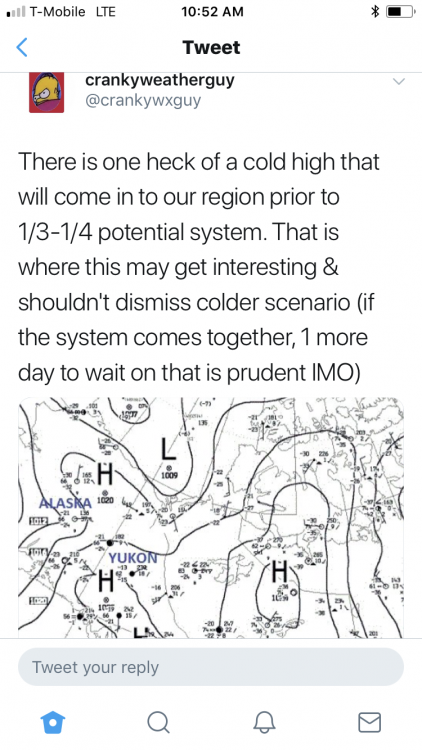
December/January Medium/Long Range Discussion
MD Snow replied to WinterWxLuvr's topic in Mid Atlantic
When we're talking about sub 980 bombs over the northeast we should at least keep an eye on it. Probably not our storm for accumulating snow but could see some cool dynamics especially for areas with elevation. Need to keep an eye on the Euro tonight. It's the one that all the other model's trended to tonight. -
December/January Medium/Long Range Discussion
MD Snow replied to WinterWxLuvr's topic in Mid Atlantic
Its become an unusable model.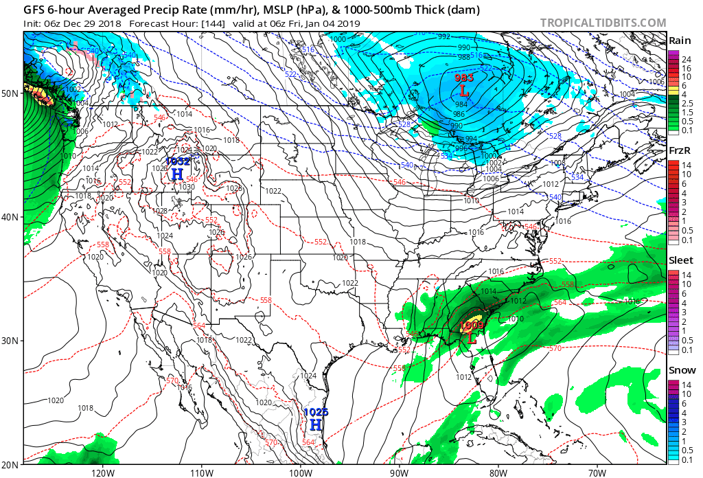
-
December/January Medium/Long Range Discussion
MD Snow replied to WinterWxLuvr's topic in Mid Atlantic
Verbatim the GFS would be a rates and elevations dependent storm. Cold air coming in switching rain to snow. Love the stall. Maybe later runs will phase northern stream even for us? -
December/January Medium/Long Range Discussion
MD Snow replied to WinterWxLuvr's topic in Mid Atlantic
The germans. -
December/January Medium/Long Range Discussion
MD Snow replied to WinterWxLuvr's topic in Mid Atlantic
A 971 over NYC on the ICON. All you would have to do is speed up the northern stream (with the cold) a little faster and we flip to snow before it pulls away to the NE. Definitely worth keeping an eye on. -
December/January Medium/Long Range Discussion
MD Snow replied to WinterWxLuvr's topic in Mid Atlantic
I know. We're all depressed around here. But to have the GFS with some rain showers moving off the south east coast at 18z while the Euro has a wrapped up sub 990 LP over Lake Erie is just crazy. FV3 does a phase job just to our north east. NAVGEM and CMC have weak waves that end as snow for us. If modeling is struggling this much at a 5 day lead then I'm not even going to worry about 2+ week lead. How much stock should we really be giving to the long range modeling atm? -
December/January Medium/Long Range Discussion
MD Snow replied to WinterWxLuvr's topic in Mid Atlantic
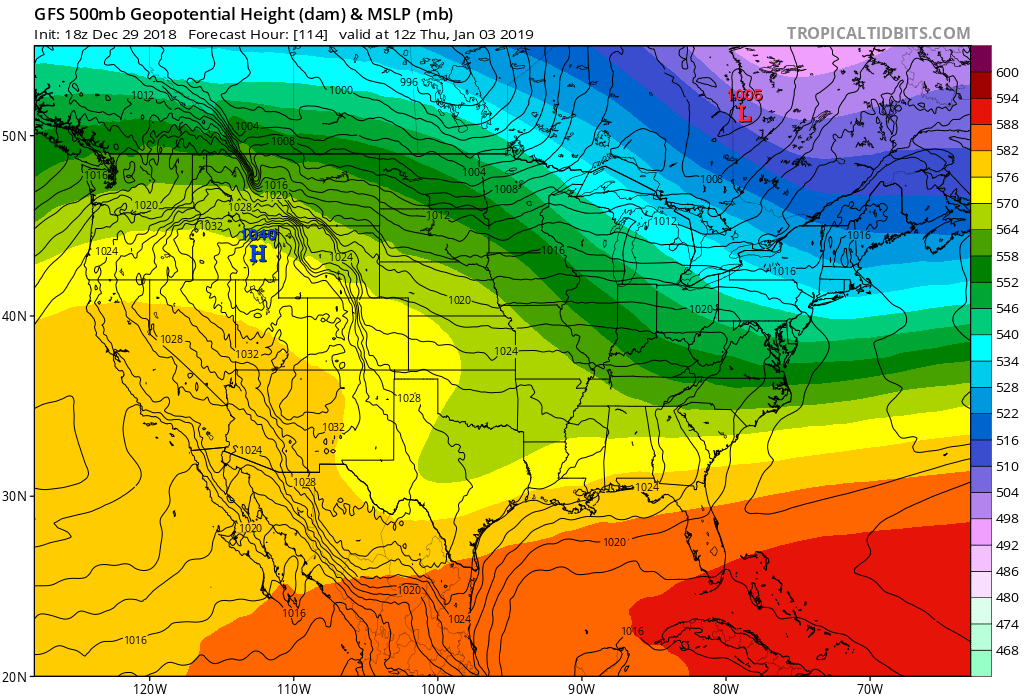
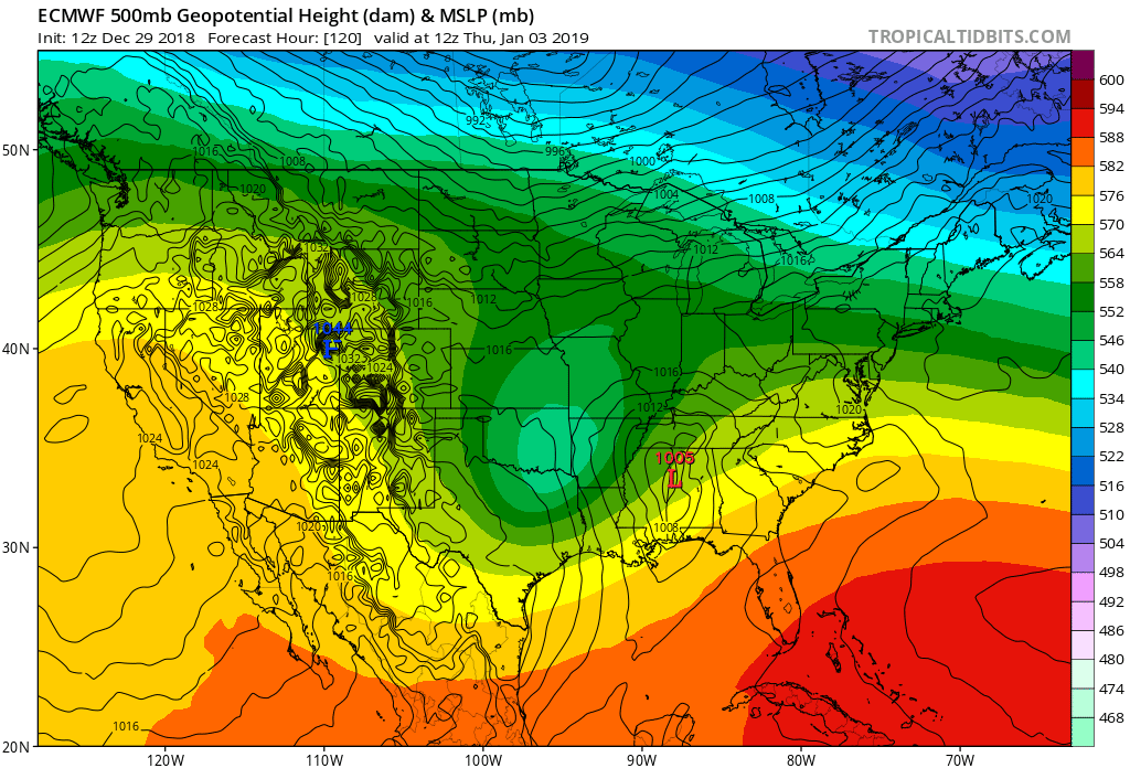
Surprised how no one is talking about the difference on the Euro and GFS for Jan 3-4.

-
December/January Medium/Long Range Discussion
MD Snow replied to WinterWxLuvr's topic in Mid Atlantic
Sure it's still 5-6 days out but it seems the model's have been all over the place with these 2 chances. Normally, it's to be expected but lately I feel like the models have been locking in a bit more quickly on things - seems like the thursday night/fridays storm has been a lock for like a week already. . Heck, the Canadian doesn't even have a storm on the 30th. One run of the GFS is north the next more suppressed. You still have quite the spread in terms of solutions. Expecting things to really start narrowing in over the next 2 days. I feel like either way the best case scenario for the MA is a snow to mix and ending as drizzle type deal. Glad we've got some things to track. -
December/January Medium/Long Range Discussion
MD Snow replied to WinterWxLuvr's topic in Mid Atlantic
Yup...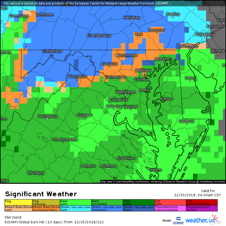
-
December/January Medium/Long Range Discussion
MD Snow replied to WinterWxLuvr's topic in Mid Atlantic
Just a couple observations... 1. Looks like areas north and west of the cities still have the possibility to get some mix/mood flakes/dusting Monday night(mason/dixon line). Wouldn't surprise me. 2. All of a sudden next Thursday/Friday looks like it could be a mixed bag (FV3) for areas north and west to start. 3. NYE still looks like it could go either way. GGEM looked pretty good last night. My point is simply this...for a total "crap pattern" we've got a couple things to at least keep an eye on over the next 10 days before the pattern really starts to get interesting. For me, half the fun is tracking, so I'm perfectly fine having a couple things to keep an eye on during what was supposed to be a shut out. -
@Bob Chill @psuhoffman Thanks for the feedback. I get it and I know it can be useful. The problem is, even after years of tracking and reading, I still have a hard time making sense of how to make sense of stuff enough to offer any good analysis of things in the long range. lol. So I keep it simple and let you all tackle trying to make sense of it all. I am thankful for you all and others taking time to explain stuff and keep trying to provide great analysis even when there is nothing very interesting on the horizon. Thanks!
-
Both GFS and GGEM have something in that time period as well. The only thing we've got to watch at this point. My two cents briefly, I learn a ton from all of the smarter posters like PSU and Chill on this board. Still can't grasp everything that is talked about when it comes to winter weather. However, for me, as someone who doesn't get to wrapped up in all of the science, I can make a couple observations that keep me grounded when a lot seems lost. 1. Models and ensembles are great inside 7 days. Outside of 7 days they shouldn't be given as much weight as they are given on this board. 2. There have been many times over the years where people here say that it's a terrible pattern and we end up with a small advisory level event. And there are good patterns that give us absolutely nothing. Believe me it happens every year. 3. Every year we are teased with amazing patterns in the long range that trend to crap as it gets closer. 4. Often we are about to "put a fork in it" because ensembles show a "torch" in a month only to completely change to a great pattern as it gets closer. I know, I know, sometimes they are right but more often than not it seems that they are wrong in the long range. So I say all this to just remind myself that it isn't even officially winter yet. We still have 3 months of chances. We may get a fluke event around Christmas which would be a huge win in my book. I for one will just let the winter play out until making a blanket statement about how terrible it's going to be before it even starts.
-
A couple morning thoughts: 1. We are still 5-6 days out. Anyone who thinks we need to be in the bullseye in the next 24-48 hrs hasn't lived in the MA long enough. Keep it a little south with a couple hits here and there for another 24-48 and we'll be good to go. Bullseye in the next 24-48 hrs and we should be worried of mixing, raining, or missing back to the south. 2. This is beginning to remind me of January 2016 just in terms of tracking for over a week. I know that storm bullseyed us for like a week but we've still been tracking this storm since Friday. Some of the best one's we've ever gotten have shown up a week + out. It's becoming more and more likely that this is going to be a big one somewhere between VA-PA. 3. I know there's not some long dissertation to back it up but think about this year for a minute. Record rainfall. Storm after storm performing or even over performing for our area. I've been thinking this winter is going to have some epic results in terms of some things we maybe have never seen or haven't seen in a while. 4. The FV3-GFS has been rock solid with this storm. Minor adjustments of 50-100 miles keeping the same general idea. Keep that in mind when reacting to the the giant swings of the old GFS Op/Euro/Canadian/Icon. And remember GEFS follows the old Op. 5. I'm not going to get that invested in any one op model run until 00z Thursday unless of course there is a massive shift towards suppression to florida or rainer for the NE
-
Not seeing much of a warmup on the op GFS....cold is lurking the whole run.
-
Very true. That's why I said this morning to be watching for the trend towards suppression. In my mind if the NS feature get's much bigger it will cause this thing to be a rainer for Florida and Georgia. It's still a possibility that this could not be a winter storm for anyone. We forget that we're still 6-7 days out. We've all seen stranger things happen at shorter leads. I'm not saying it's going to be a non event for anyone but I still think it's a possibility.
-
But we had the signal for a storm across all modeling last year and then it went poof inside 5 days. That possibility has to be on the table at this point. Not saying it will happen or that this pattern isn't a good one...
-
At a 7 day lead...the only reason to get really nervous is if over the next 3-4 runs the storm gets squashed to almost nothing. If that happens the likelihood of it coming back is pretty bleak. However, as long as model's still show a storm even in the Carolina's/southern Virginia i'm not going to worry about suppression/details until 4 days/96 hrs out. The main concern at this point should be a trend toward a total squash. I use to think a suppressed storm would always trend north until last year.
-
But the low cuts further north and west than 12z before it transfers inland along the coast. That's two runs in a row that show the same cutter solution. This is that last thing we want to see run over run.