

OSUmetstud
-
Posts
16,433 -
Joined
-
Last visited
Content Type
Profiles
Blogs
Forums
American Weather
Media Demo
Store
Gallery
Posts posted by OSUmetstud
-
-
3 minutes ago, dryslot said:
And was the opposite here on this last one, And several previous to that one.
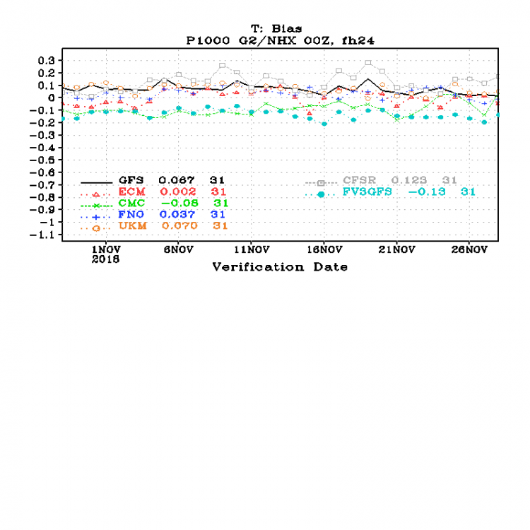
Thats interesting. The surface warm bias is categorically a thing at all lead times.
-
Just now, dryslot said:
Hopefully better with the thermal profiles then its predecessor because it blows chunks.
Here we seem to have this thing where it's too warm at the surface but it's too cold at 925/850...not sure if that's true in NE. For example, the 00z GFS last night had several inches of snow for the Avalon Peninsula basically at zero hour which never occurred.
-
In all seriousness...I've subjectively noticed that the fv3 gfs doesn't seem to have that severe phasing/suppression/se bias that the op GFS has in the short to medium range.
-
6 minutes ago, Typhoon Tip said:
Not to be a douche ...but, not much more than any guidance saying yes or not to that event/time range -
All these guidance types have been taking turns.
Nick was just saying that wave spacing is an issue and he's right. I commented on that myself a while ago - the flow is festooned with S/W's, any one of which could get the job done but when the flow is fast and their hunched together (for lack of simple way to say it) they don't have time to engineer the gig ...
I think things are a bit better for the 7th to 9th than the 5th for SNE.
-
3 minutes ago, TheCloser24 said:
FWIW, FV3-GFS shows major noreaster 12/8-9.
I already like this version better.
-
 2
2
-
-
9 minutes ago, 40/70 Benchmark said:
Yes, but when you work during the day and step away, usually an increase in post frequency is an auspicious indicator.
Hey, at least I know which islands in the maratimes are most prone to wind funneling....and its not OT because it happens in December, I guess.
Stop being a bitch
-
 1
1
-
2
-
-
2 minutes ago, 40/70 Benchmark said:
I saw all of the recent posts and was hopeful that some piece of guidance had trended favorably, only to discover a slew of posts chronicling se Canada's travails in the wake of this latest system.
Splendidly picture perfect-

Wave spacing issue is real but there's potential. Not too much more to say than that.
-
1 minute ago, Typhoon Tip said:
The hyperbolic commentary is cute in that ... how does wind "funnel" across "open ocean" - nice.
But yeah, almost scary lookin' ... cold deathly N. Atlantic November witch water engulfing the land...
Well there's a complex inlet between Cape Breton County and Victoria County in that area he's discussing that gets gap wind contributions from the NE (and SW) since there's higher elevations on either side of the Seal Island Bridge area.
.jpeg.ef650d81f86619158c08f4c0e05d219f.jpeg)
-
7 minutes ago, Ginx snewx said:
Apparently
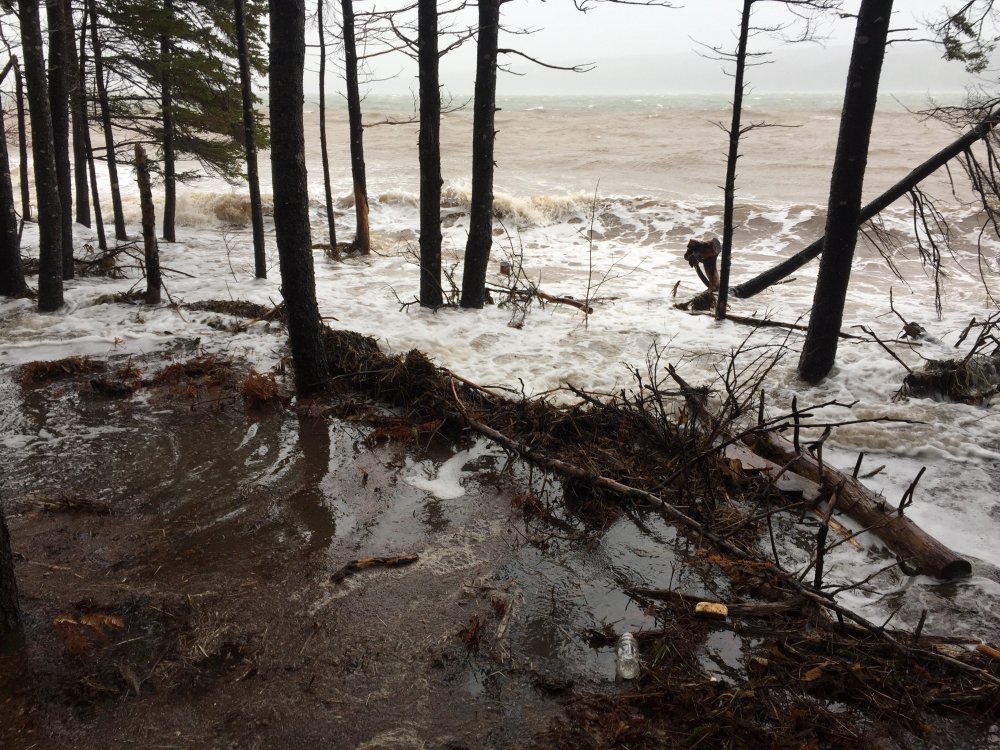
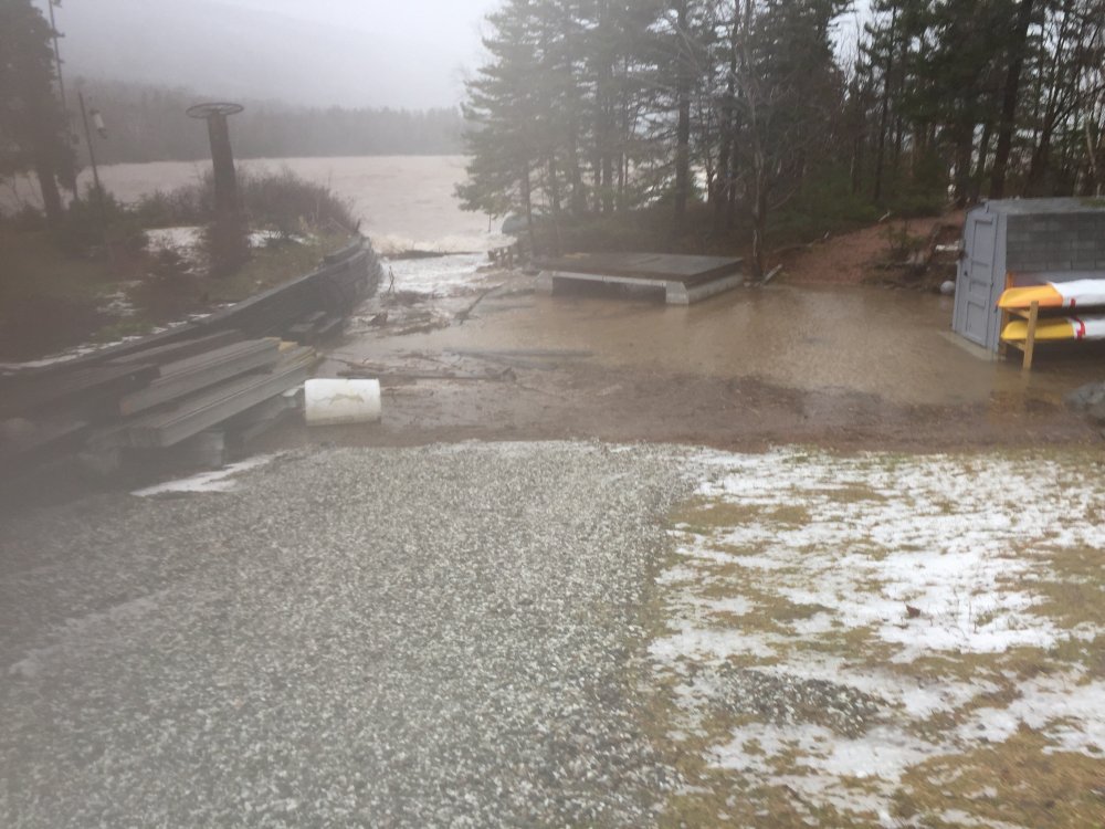
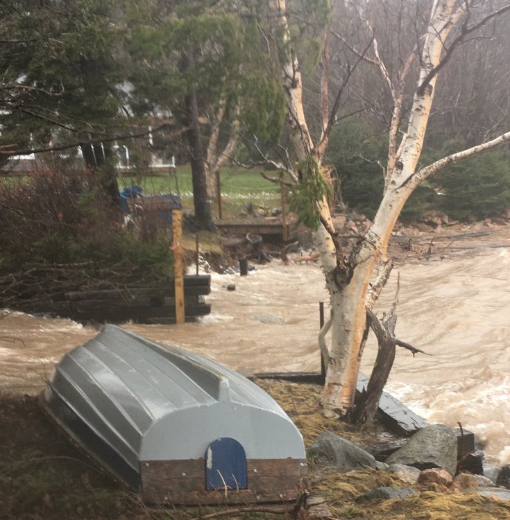
Yeah. This is from our climate consultant at the office.
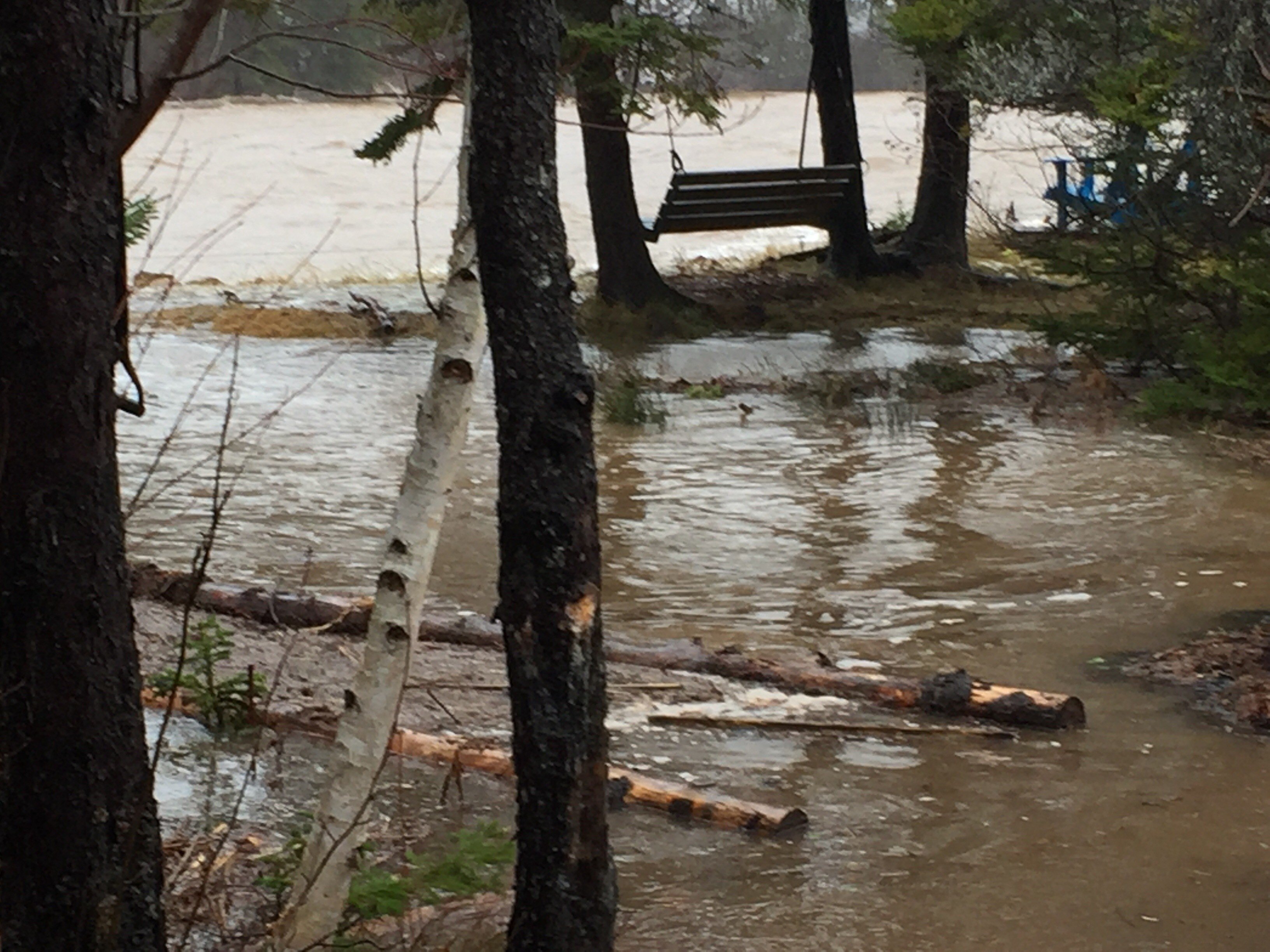
My parents live on the Bras d’Or Lakes about a mile from the Seal Island Bridge (where Wood has an RWIS station). They sent me the attached pictures this morning of the storm surge and related flooding and damage they are currently experiencing. The winds are northeasterly, meaning they are funneling down through from the open ocean, resulting in a direct hit on their property.
The water is about 3-4 feet above the high-water mark – the highest we have ever seen it since our family bought the property in the 1960’s. It has washed out cribbing along the shore that my dad and I installed when I was 12yo (not yesterday but it’s held up pretty well until now). We have been reinforcing the shoreline with large granite boulders over the past few years, which seem to be holding up, but a lot of the shoreline is still exposed and inundated about 15-20 feet inland (more in some places). And the winds are expected to continue at least throughout the day.

-
3
-
-
1 hour ago, Ginx snewx said:
Our boy Eddie up in Nova Scotia getting blasted by the NNE snowstorm gone wild.
This was run of the mill for here in eastern NL Didn't even gust to 55 KT at yyt. Cape Breton Highlands is getting the best of this one.
-
4 minutes ago, Baroclinic Zone said:
But only an easterly wind would hurt Boston whereby winds from just about every direction hurt the Cape. You need a pretty cold system in early December to overcome background conditions.
I'm getting hurt by 36F SSTs lol. (System already has marginal temperatures.)
-
1
-
-
4 hours ago, Go Kart Mozart said:
I was checking out Environment Canada to see how this storm will effect the Maritimes. The Canadians have this beauty for a warning, which I strongly suggest we adopt:
Wreckhouse wind warning in effect for:
- Channel-Port aux Basques and vicinity
Very strong wind gusts are expected or occurring
Strong easterly winds are expected to develop this evening with gusts increasing to 100 km/h late overnight tonight and to 120 km/h on Wednesday.
Gusts will further intensify to 140 km/h Wednesday evening before diminishing somewhat as winds become northeasterly, with gusts to 100 km/h persisting into Thursday from this direction.Be prepared to adjust your driving with changing road conditions due to high winds. Drivers may lose control of their vehicles; tall vehicles are at risk of being overturned.
Wreckhouse wind warnings are issued when there is a significant risk of damaging winds.It's a mountain wave type thing. The LLJ get slammed to the ground in the Codroy Valley to the lee of the table top mountains to the east which are kind of a plateau. This is actually not a perfect situation for these winds Wednesday into Thursday. It's more effective when the atmosphere is very stratified north of a mid-winter warm front. I've seen almost 200 km/h since I've lived here. A lesser type of wind occurs downwind of the Chautauqua Ridge in areas like Dunkirk south of BUF. I'm sure there are areas in the Greens and Whites that can see similar.
-
Just now, weathafella said:
Delayed. Finally running now out to 51 on SV
Thanks
-
Is the euro broken? Its not coming in at wxbell
-
14 minutes ago, RUNNAWAYICEBERG said:
It’s the wave of the future. It’s coming, just slower than we’d like.
Live free or die, except when it comes to smoking a plant
-
That's kinda silly lol.
-
45 minutes ago, CoastalWx said:
How did Cat 1 Michael work out?
Is that guy a met? We can't even get greater than a 1.0c on the weekly data and he makes a statement about moderate to strong Nino currently.
I get the pushback against epic blizzard tracks all the time but no need to overreact to the weenies and make yourself look like a fool.
Much of the bullshit pattern in the coming few weeks is probably the result of intraseasonal mjo forcing, not the Nino itself.
-
1
-
-
The gefs has it like day 13 to 15 just like the eps.
-
40 minutes ago, ScituateWX said:
WWB?
Westerly wind burst. (ENSO tropical forcing stuff)
-
Aerosols from travel? That's interesting though. I remember you guys discussing the Grinch anomalies before.
-
Just now, ORH_wxman said:
Weeklies were an epic disaster for a good chunk of December. Hopefully they are wrong. Week 3/4 do have very low skill, so we've got that going for us.
Does anyone have any skill numbers for the weeklies?
-
2 hours ago, weathafella said:
I read on Twitter where euro seasonal December is cold in the latest release.
I was confused about Ben's post. Is there a mid month update or is it the same stuff from the early November forecast?
-
5 minutes ago, RUNNAWAYICEBERG said:
Are you afraid your turkey will thaw out?
He should have eaten his in October lol
-
20 minutes ago, leo2000 said:
Are you talking about the 12z Euro?. The 00z Euro shows mild air coming in.
Dude the 00z euro is friged for you for Thanksgiving.


December Discussion
in New England
Posted
Ah ncep just reversed the bias. So cold and snow for all on the new GFS