

OSUmetstud
-
Posts
16,433 -
Joined
-
Last visited
Content Type
Profiles
Blogs
Forums
American Weather
Media Demo
Store
Gallery
Posts posted by OSUmetstud
-
-
Just now, 40/70 Benchmark said:
Looks like a better defined EPO, too.
PDO you mean?
-
Just now, 40/70 Benchmark said:
Thank you for posting that...Bingo...perfect sense.
Get ready sne...its coming.
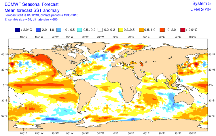
Sorry this is the more direct comparison. I posted the wrong chart from the November run. Point remains, however.
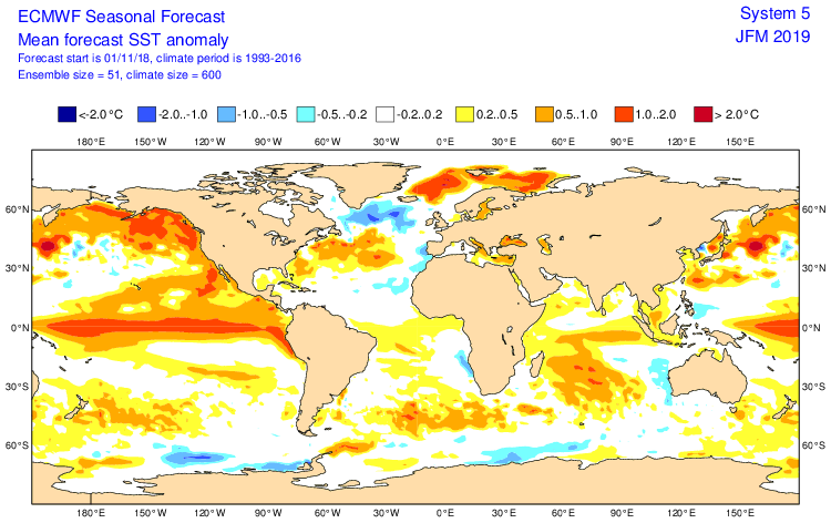
-
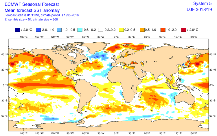
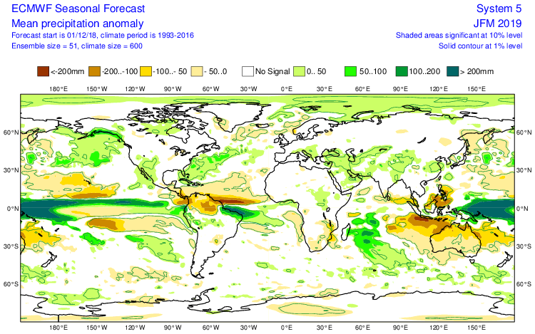
You can see a slight weakening in the Nino SST anomalies from the November to the December run and a movement west. Also of some interest is the possible return of the -AMO.
-
3 minutes ago, CoastalWx said:
Earlier when I posted that, I just meant for pacific flow.
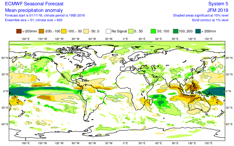
Yeah I was just talking in general. The last euro seasonal has less dry anomalies in the Midwest and slightly less precip associated with the subtropical jet off the us east coast. New one is on the bottom.
-
Just now, 40/70 Benchmark said:
Probably because el nino is weak....more n stream.
Yeah Id guess the same.
-
36 minutes ago, Ginx snewx said:
Especially hostile when there's no precip
You can see a reduction in the strength of the subtropical jet precipitation on the latest euro seasonal.
-
Just now, Ginx snewx said:
Its only just begun
I hope so, the patterns that have benefited you guys the past few years havent been the best here.
-
6 hours ago, Ginx snewx said:
Lol oh ok, absolutely. Hey you have to be close to these sub 970s that zip by, how much snow so far this year
We're doing alright, so much better than last year. This system was disappointing compared to what it could have been, just a bit too far offshore. Ended up with 4". We have about 32" on the year so far, with about 14 or 15" on the ground. Nice start to the season.
-
Just now, Ginx snewx said:
I think it performed fantastic for both east coast USA winter storms this year, in fact it was stellar
That was a bit tongue in cheek. Models improve every year as you are aware. The 2018 euro is objectively better than the 2013. As is the GFS and anything else out ther.
-
 1
1
-
-
Ah yes the 2013 vintage euro. Very good year.
-
1
-
 1
1
-
-
1 hour ago, leo2000 said:
How is your blizzard coming along?
Its starting now.
-
16 minutes ago, 40/70 Benchmark said:
Keep watching that trend of an earlier phase...another 24-36 hours of that could make a difference...long shot, sure.
Yep. I was basically putting a fork in it...but now I'm intrigued for here at least.
-
man this pv over eastern Canada aint no joke.
-
1 minute ago, ORH_wxman said:
It does look like it has potential after 144....my preferred evolution on this storm though would be for things to happen sooner....get this much further north off to the west and then redevelop it.
Yeah, I wondering how much of the northern stream energy was digging on the backside over Minnnesota.
-
40 minutes ago, jbenedet said:
What’s your forecast?
I think suppression is the most likely. I was fooling around.
-
1
-
-
18 minutes ago, jbenedet said:
Oz CMC is only pc of guidance without a -NAO look to it off the east coast, and therefore is beginning to make the most sense imo.
Are you speaking ex cathedra?
-
1
-
-
33 minutes ago, OceanStWx said:
It'll be comforting to have our favorite biases still hanging around with the new guy.
Yes, it seems a bit better from what I've noticed, but I think its still there lol.
-
8 hours ago, OceanStWx said:
That can be true for southern stream waves that have a lot of convection. Modeling (and GFS in particular) can have a progressive bias, and the latent heat release and resulting ridge building ahead of stronger systems can be underforecast by NWP.
There is a physical explanation for the NW trend.
GFS is almost unusable with storms like that. The same thing appears to be happening with the Day 4 low and my weather. ECMWF/NAM/UKMET/GEM/EPS etc. are all further northwest and a "hit" while the GFS is a clear miss to the southeast. The FV3 is a bit closer, but still a miss.
-
1 hour ago, leo2000 said:
Thanks.
-
Where do people get the ECMWF mjo plots?
-
1 minute ago, CoastalWx said:
For 9 or whatever days out, it’s a decent look. We all know a small nuances can screw up a decent look, but I’m not sure what people expect?
Yes of course. Its early December and it's so far out so the chances are against it. But a reasonable threat I think for the time frame its at.
-
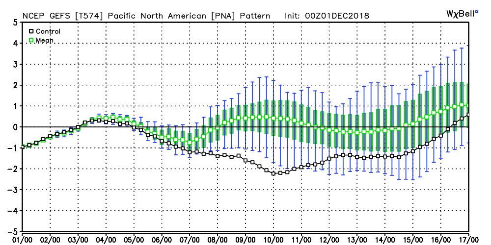
We have a rising PNA and falling NAO during the potential storm time frame. Isnt that exactly what you want?
.png.5e1a2a1f7133eae5150458f325390abd.png)
-
7 minutes ago, ORH_wxman said:
Euro is looking pretty tasty in clown range for the Dec 9 threat.
Nice "shed" solution
-
1 hour ago, 40/70 Benchmark said:
I couldn't care less about OT....I was just pissed because nothing has improved as of yet, pending the EURO.
I get it. Its all good.
December Discussion
in New England
Posted
Poppers hates when you reference ecmwf guidance.