

OSUmetstud
-
Posts
16,433 -
Joined
-
Last visited
Content Type
Profiles
Blogs
Forums
American Weather
Media Demo
Store
Gallery
Posts posted by OSUmetstud
-
-
Just looking at soundings and different ratio methods id think somewhere in the neighborhood of 12:1. My general go to is cobb 11.
These iowa state bufkit derived plots are nice...especially when youre only on a phone and cant use bufkit.
.thumb.png.eee7778a3bb185a2564fb80e74b2068d.png)
-
Nam is decent overall.
-
4 minutes ago, Thinksnow18 said:
I think we will know more as the storm jumps the Rockies later tonight early tomorrow. The confluence isn't our friend ATM but it also is keeping the storm from just blowing out to sea...is this almost becoming a Miller B type storm? Initial low to a transfer along the coast?
I wouldnt call it that since there isnt mid level closure. The trough is open from 700 and upward across the whole ne. Redevelopment comes via confluence. The 500 vort itself doesnt go south of Long Island.
-
 1
1
-
-
Just now, vortmax said:
Question is, how well is it doing for this storm? 12z should clear the air a bit.
Yeah storm-specific verification would be great, but tough to do obviously. I dont have access to the 06z ecwmf since jb doesnt have it on wxbell but i did notice the 00z was faster and the northern stream kicker dropped in just a touch slower...resulting in a slight improvement. Also the biggest difference between the 00/06z gfs fv3 and the 00z ecmwf appears to be the amount of confluence over the ne. 500 heights are 15 to 20 m lower on the ecmwf, forcing the farther south track and earlier redevelopment.
-
1
-
-
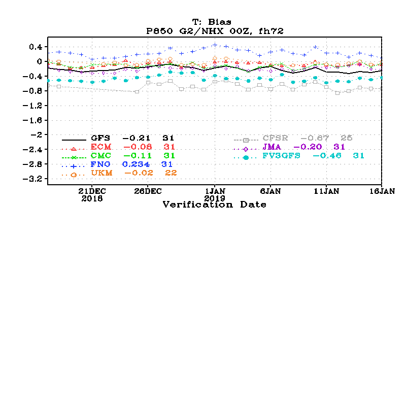
6 hours ago, CNY-WXFREAK said:
I'm really starting to like that FV3 new upgraded GFS as it looks like a solid model both in resolution and accuracy but I haven't been watching it as much to see how it has done with past events so now I will make a folder of this weekends and future storms for posterity, nice! Wanna see how it does!
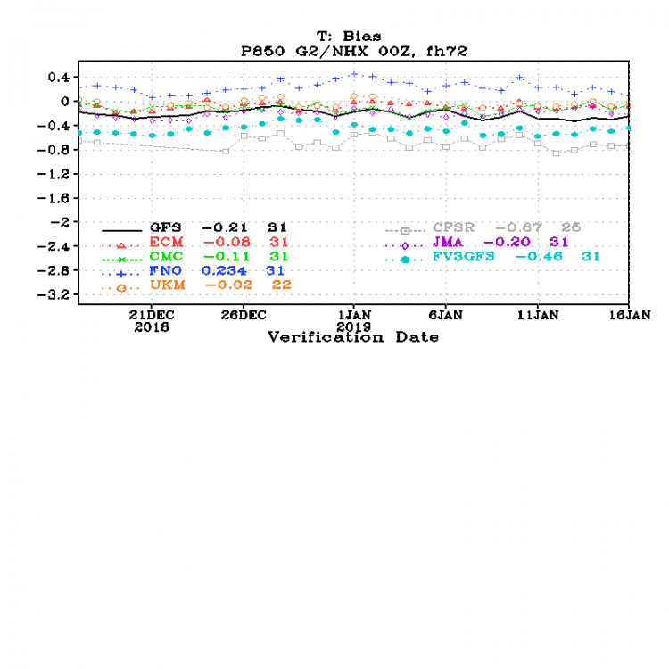
Ty, Its a slight improvement over the current gfs but it still lags the ecmwf and ukmet significantly in verification score. Its also significantly cold biased through much of the lower trop. Its not operational yet so they can still make tweaks (once the govt reopens, of course).
.thumb.png.9d4f7c7f7a4a980c72b7559673ca3317.png)
-
3
-
-
Nam is way more amplified but it super suppressed on 18z and 12z.
-
6 minutes ago, vortmax said:
Trying to wrap my head around this. So would that process enhance the downstream ridge causing a more NW track?
Yea. Its why you often see a bump nw in modeling the last 72 hours or so before a storm. Models cant properly resolve the increasing heights downstream of convection.
-
1
-
-
I think the quicker trend is important to make this bigger for ny. 18z ecmwf was quicker and better...same with the 18z gfs and fv3 gfs. The 18z ggem appears to be slightly faster than the 12z. I think the forum wants to see that trend continue. Even if the "B team" is 30 percent correct...that will help a great deal.
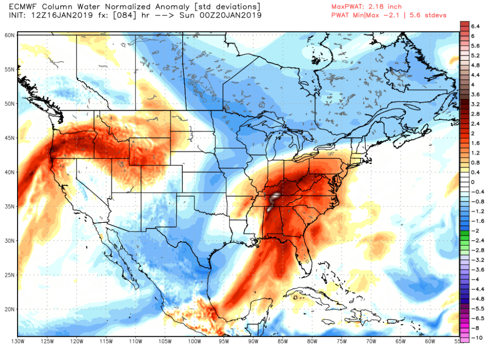
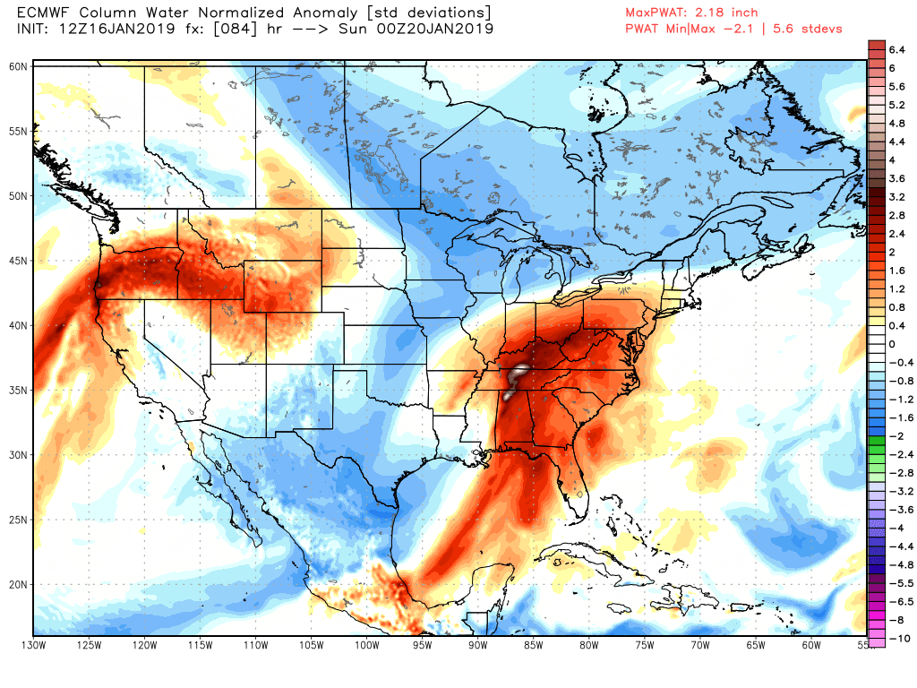
Also, very anomalous pwats ahead of the system could cause some undermodeled convection pumping latent heat release into the downsteam ridge.
-
1
-
 1
1
-
-
19 minutes ago, rochesterdave said:
Why are 6/18z models less reliable? Lower resolution? Less data input? I’ve always heard less reliable but I never know why?
Im not going to die on a hill about this but 99.99 percent of the data in the models is not from balloons. So there's no reliability issues between 12z and 18z. In fact, model verification scores would tell you that an 18z 78 hr prog should have less error than the 12z 84 hr prog from 6 hours earlier. Occasionally you will see an abrupt change at 12z or 00z because a ballon happened to catch a poorly sampled shortwave out of the arctic. The cold temps and paralax error in the arctic make mid level shortwaves difficult to "see" via remote sensing from goes satellite.
-
6
-
-
35 minutes ago, DeltaT13 said:
There are some subtle things about the presentation of that sfc low on 18z that definitely make it better. I mean its nothing spectacular, its just in the right direction. That said, its the 18z...
Will in sne said it was slightly more amplified and faster.
-
12 minutes ago, rochesterdave said:
That screaming jet has been our problem all winter
That was the subtropical pac jet. Different thing.
-
1
-
-
8 minutes ago, BuffaloWeather said:
The eps was phased with all of yesterday’s runs, it went way southeast today. The spread on eps was so small yesterday, surprised at the big leap. Still 3 days out though.
Right. I think the eps/ecmwf solution is more reasonable since the screaming polar jet from the pv doesnt generally promote phasing.
-
4 minutes ago, ORH_wxman said:
Yeah rgem's wheelhouse is like 24-36 hours. I don't really pay attention to it much beyond that.
Right me too.
-
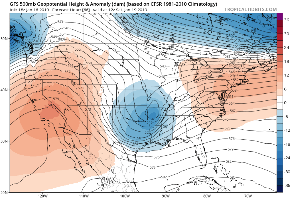
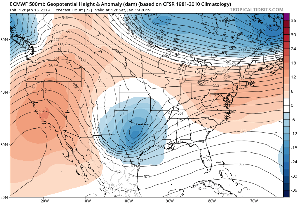
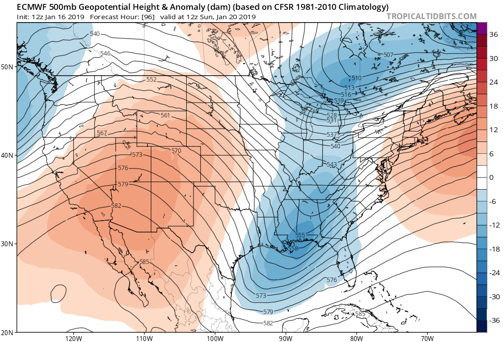
Ecmwf has more separation from the northern and southern stream at 72...the gfs has a more intense and negatively tilted southern stream shortwave. The ecmwf doesnt partially phase with the northern steam like the gfs does through 96.


-
1
-
-
2 minutes ago, Syrmax said:
Not buying that for this event. It's an slp placement issue.
Hmm yeah it does seem to be more wholly different. Gfs is faster.
-
15 minutes ago, Syrmax said:
GFS hates SNE. Consistently wants to blowtorch them. Dont know that it's right but I've seen that play out countless times in the 2 decades I lived there. Not exactly uncharted territory.
It doesnt know how to cad properly
-
22 minutes ago, ORH_wxman said:
Actually I take that back....GFS does have the clown range RGEM on its side....RGEM has the low even further west trying to cut into NY State.
My friend at ec told me its experimental so dont give it too much of a hard time lol.
-
2 hours ago, DeltaT13 said:
Buffalo already posting watches. “That’s a bold move cotton, let’s see if it pays off.”
Eh most of buffalo's synoptic snowstorms have some sort of coastal redevelopment. Its unusual not to.
-
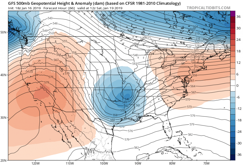
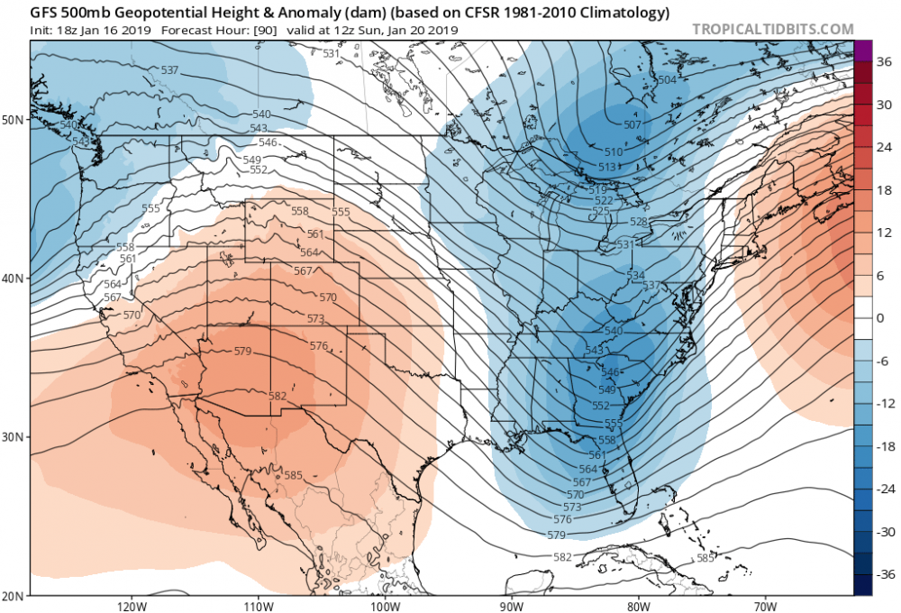
There is a real trend to not allow any phase with the chunk of the pv over the ov...which makes this basically a southern stream system running into an east-west oriented pv "wall"...so naturally there is a trend towards coastal redevelopment. It probably decreases the chance of anyhing particularly historic for western and central ny...but still a very good snowstorm is likely i think.
-
3 minutes ago, ORH_wxman said:
WTF is that? It goes from like SW VA to the benchmark...even a bit east of the BM
Drunk?
-
3 minutes ago, CNY-WXFREAK said:
If its a bad night of models lets at least hold it together and not have a complete meltdown yet, lol, as one model suite won't change much and there's still 20 runs to go,
 ! Feels like we've been tracking this thing for weeks, lol!
Nah. Meltdowns are more fun.
-
 1
1
-
-
I mean get excited. Its been a tough winter thus far and this looks like a really nice storm for the area...but id sell widepread 3ft kuchera amounts.
-
1
-
-
1 minute ago, BuffaloWeather said:
Hey Nick, what are your thoughts on storm totals? Thinking a general 10-20" across this area?
Thats probably a decent first guess. Id beware of some of the obsene qpf being thrown out in the models. In the end, its still not a closed off system in the mid levels. Risk of less than ideal snow growth with warmer than you might expect 600 to 700mb layer where lift is located.
-
3
-
1
-
-
2 minutes ago, CNY-WXFREAK said:
Yeah I know but with the precip output being shown by most models, I can bet the Omega and RH values should be outstanding and with temps in the low teens, it doesn't matter what the UVV or RH is, lol, cause I'm afraid the flakes will look like peas rather than dendrites, and I'm sure we all don't wanna see that happen, lol!
I know its early but look at this sounding for KFZY for 00Z Sunday!! Wowzzers as that is just an incredible looking sounding, lol! Only real thing lacking is the wind as their not all that strong but its early into the event at this time so they could and probably will change as we get closer!

Nice. That sounding is why you wouldnt generally forecast anything over 15:1.
-
2
-
1
-
.png.47571ef38d2de883d594586a0e3a764a.png)
.png.182a7538e9db8e9d0a5c93e8e8e974cc.png)

Upstate/Eastern New York
in Upstate New York/Pennsylvania
Posted
Could be. Its always tricky. But a deep area of modest lift at different temperatures is more indicative of smaller agreggates than large dendrites. You end up with a dry but dense snow.