

OSUmetstud
-
Posts
16,433 -
Joined
-
Last visited
Content Type
Profiles
Blogs
Forums
American Weather
Media Demo
Store
Gallery
Posts posted by OSUmetstud
-
-
7 minutes ago, Thinksnow18 said:
Ok yes it says ridge, however it does say cross polar flow, staying power etc...how is all that possible when the models all show cutters?
Cross polar flow via an -epo (alaska) block doesnt necessarily stop cutters.
-
Sorry. Should compare apples to apples.
-
 1
1
-
-
The cpc method is considerably different than the method used on wxbell
.png.f6c5ec3e8fee9c7a857c7070784d5370.png)
-
2 hours ago, Thinksnow18 said:
So I read the KBUF AFD this morning, specifically the long range for friday through next Monday. The discuss the perfect set up for cross polar air die to a +PNA and Greenland block supercharging the air as the PV drops to the northern Great Lakes! They state this will have lasting power through the foreseeable future too!!! Elaborate then why the next 3 systems after that all cut west of us giving us rain instead of snow?!?!?!
They dont mention a greenland block. They use the term ridge.
-
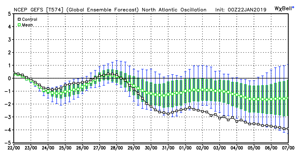
Maybe at some point we could add negative NAOs to ray's fraud five.
-
 2
2
-
-
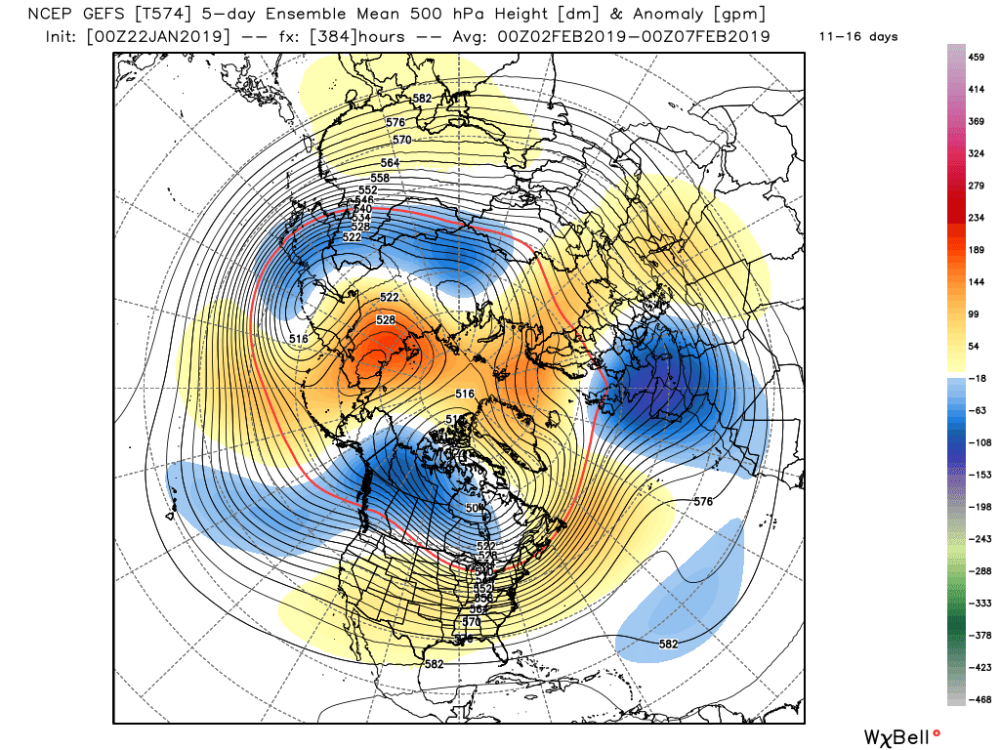
Im kinda liking early feb for some miller b type action.
-
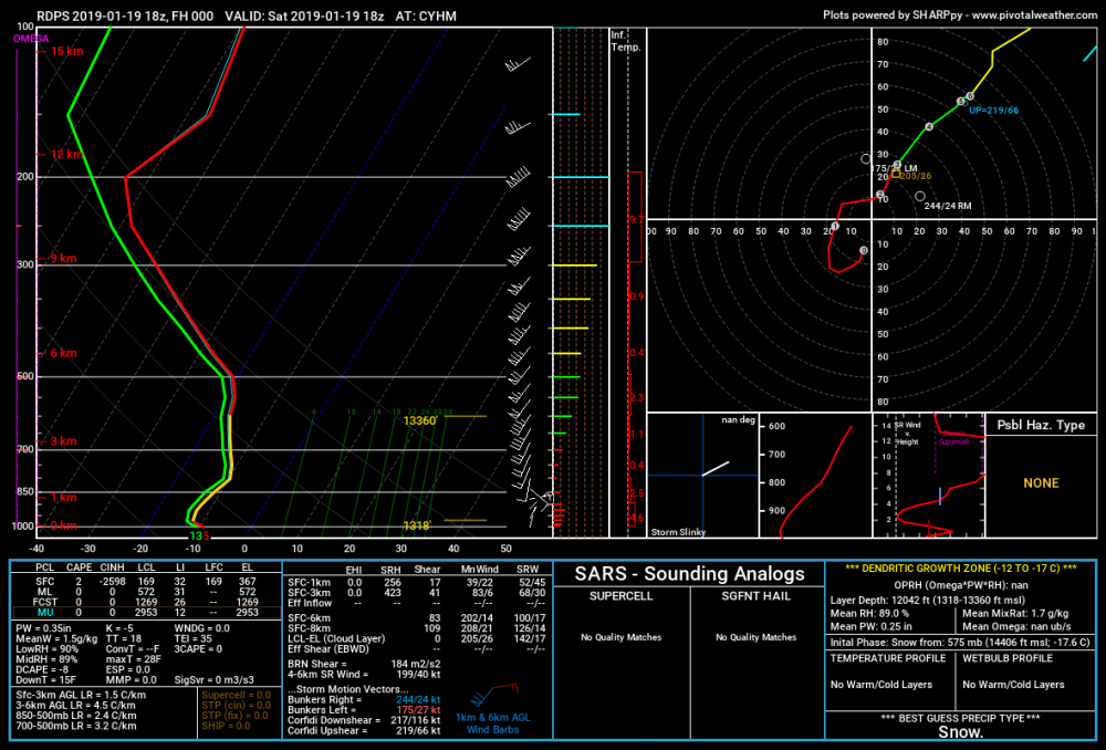
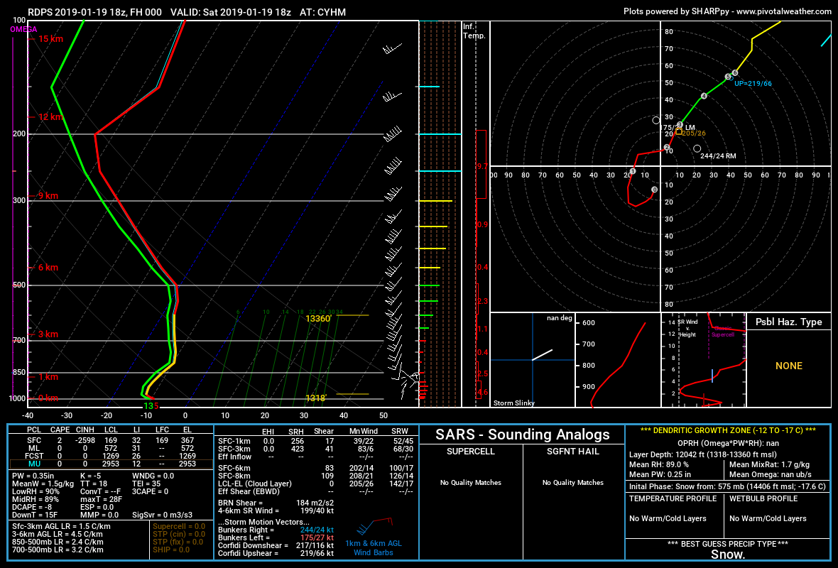
There was suggest that better ratios closer to 15:1 would manifest in the 06z to 09z time frame during good mid level omega through the sgz. I wonder if that verified. Buf had almost dead on 10:1 yesterday on the climate report.
-
48 minutes ago, BuffaloWeather said:
Totals would have been much higher with better dendrites. The pack right now is thick compared to typical 1:20 type stuff. I'd wager it was 1:12 throughout the event. Going to do a sample later of the depth SWE.
As expected
")
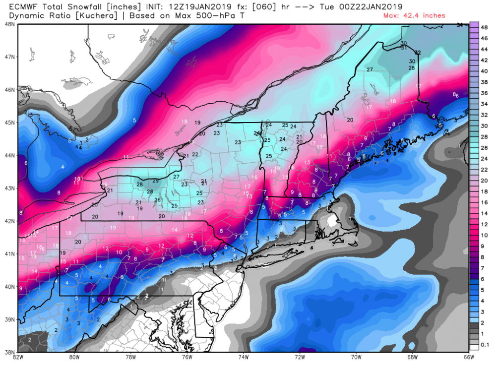
I wonder if there will be as many kuchera masturbatory maps on the next storm lol.
-
1
-
2
-
-
-
2 minutes ago, tim123 said:
Looks like lake enhanced can tell l from those huge fluffed up flakes
Yeah thanks. Its obviously lake enhanced. That doesnt mean it was 50 cm.
-
Just now, BuffaloWeather said:
48 cm is 19”? Might be possible?
I just dont buy it. All of these incredible snow shots on twitter are super zoomed on tape measures. That sounding doesnt lend itself to super lake enhanced rates. 20 cm i could buy.
-
1
-
-
Idk man. I just dont buy it. Ancaster is very close to the airport in Mt. Hope.
-
-
1 minute ago, BuffaloWeather said:

Im going to say those reports are nonsense. 9 cm (3.6") so far at cyhm. Probably more a bit more closer to the lake. I dont know who the met is reporting larger amounts via tape measurer on twitter.
-
Just now, rochesterdave said:
That’s just a meso analysis, current pressure? Do I have to click on it? Thanks!
you do, under the surface tab there is a link for 2 hr pressure change.
-
6 minutes ago, rochesterdave said:
Anyone have a map or link for 3 hr pressure falls?
https://www.spc.noaa.gov/exper/mesoanalysis/new/viewsector.php?sector=19#
-
Wouldn't your area get subsidence in northeasterlies?
-
Just now, CNY-WXFREAK said:
WTF? Whats that Tim?
he runs his own model in his basement
-
1
-
-
Main improvement was for the western folks. But, BGM might start to worry about a brief dryslot with these further amplifications.


-
2
-
-
mine is weatherbell (JB) and the other is weathermodels.com (Ryan Maue). Could be some slight differences in calculation.
-
Just now, CNY-WXFREAK said:
Did this thing slow up too?
.thumb.png.fb77658d6d06e9eecb91264207164000.png)
The increasing phasing with the northern stream slows its progress and maintains moisture over the lakes for a longer period of time.
-
2 minutes ago, CNY-WXFREAK said:
Euro doesn't have Ku
Oh, and i'd sell the 21:1 ratios in BUF.
-
2
-
-
7 minutes ago, tim123 said:
I think someone roc lake shore to about Fairhaven gets near 3 feet buy Monday morning
you're like James in SNE.
-
4
-
-
13 BUF, 18 ROC, 15 SYR


.png.de87bbae3d25d51a97b691b22b5c02c0.png)

Upstate/Eastern New York
in Upstate New York/Pennsylvania
Posted
Isnt there only really one cold front passage that im seeing for buf anyway?