

Tatamy
-
Posts
2,028 -
Joined
-
Last visited
Content Type
Profiles
Blogs
Forums
American Weather
Media Demo
Store
Gallery
Posts posted by Tatamy
-
-
First snow shower of the season in progress here.
-
 4
4
-
-
3.52” storm total.
-
1 minute ago, Will - Rutgers said:
I hate this crap, it's like "FLASH FLOOD WARNING FOR YOUR AREA" except the AREA is 25 miles away.
We're well on the periphery of this.
I don't really blame the people managing this, I know enough about weather to know I'm not in danger. It's basically for people who decide to go out driving, at least for my area. For these storms I'm not even sure we're getting rain.
I have been under the FFW for over an hour now. Reports of many local roads under water and impassable.
-
Just now, NycStormChaser said:
That happens to me every single time, even when i expect it
That happened to me an hour ago. These warnings are covering a large area.
-
Tornado warnings issued for much of central NJ
-
I am at 3.04 for the day with 2.94 of it this evening.
-
2.92” of rain so far this evening.
-
Tornado warnings now in effect for much of eastern/southeast PA right now.
-
The front looks to be stalled along the I-78 / I-287 / 202 corridor from about Quakertown to Clinton to Far Hills and to the north and east. There is a 10 degree temp difference across the front right now. I am at 56 now and much of NJ is in the 60’s. That would seem to be the area most at risk for a spin up over the next hour or two.
-
Tornado warnings in effect for a large area of eastern PA right now. 2.66” so far this evening. The triggering mechanism seems to be related to the front which is located just south of me. All kinds of rotation on radar right now.
-
1.51” on the day so far.
-
5 hours ago, sferic said:
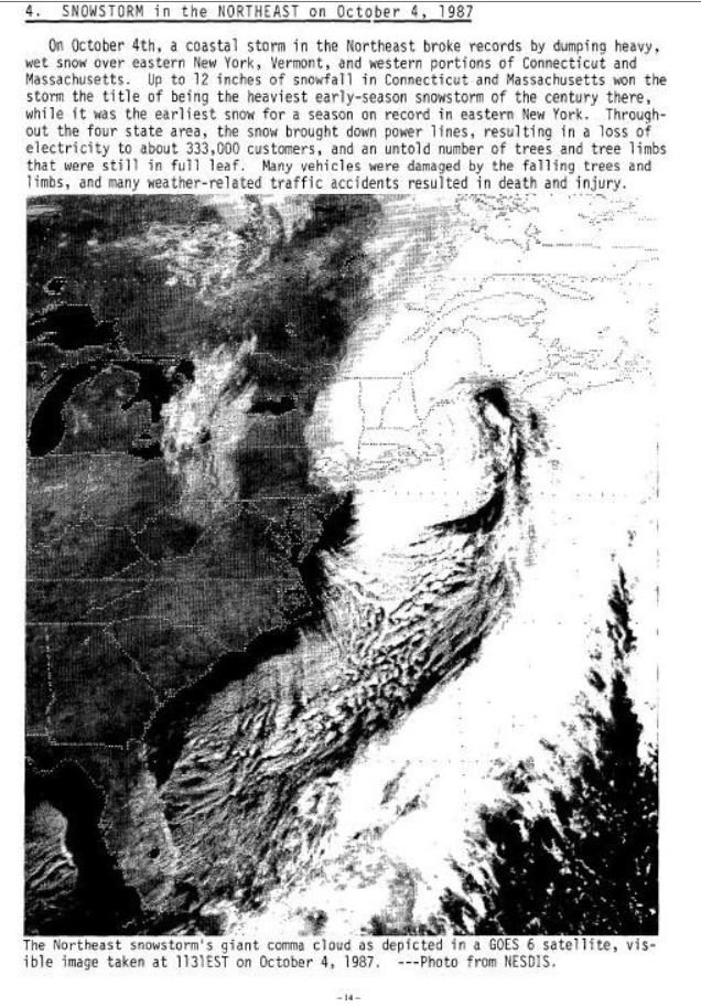
With all this warmth, let's go back 31 years ago to October 4th, 1987
Huge snowstorm north and NE of NYC
NW Jersey and Northern Westchester had 3 inches while further North way over a foot.
I remember just 30 to 40 miles up the thruway from NYC it was snowing as I was in it. WCBS AM also reported a sleet pellet in Hicksville NY
What a storm

I actually drove up north from LI that morning to see where the accumulations were. I believe it was a Saturday morning. There was a coating on grassy surfaces from about central Westchester on north however it was just cloudy. I drove up I-684 to I-84 going west to see how accumulations were in the high country to the west of Brewster. Once I started going up that grade accumulations started to increase rapidly. I don’t think I got as far as Stormville before being forced to turn around due to heavy snow. At that point there was at least 6” on the ground. It was a classic early season elevation event.
-
Continuous lightning and thunder with the squall line that is passing my location. Had a period of marble sized hail as well within the past 20 minutes.
-
54 minutes ago, Snow88 said:
Quite possible with the big ridge
I am on board with forky.
-
1
-
-
Cat 4 130 mph with 5pm advisory.
-
1 hour ago, LongBeachSurfFreak said:
I agree verbatim it’s a big erosion mess. We are way way out though. As others have said and using the don Sutherland rule chances are high it’s out to sea.
One thing that’s always missed is a fish storm is not a fish storm. All we have to do is get Florence to about 30/50 and it will send large long period swells. That’s almost certain now and days on end of big surf kills people every September. Life guards go off duty and the waters are warm. People think they can handle it and get stuck in a rip current. At Jones beach we are open with life guards for another 2 weeks. At most beaches life guards are finished for the season.
Strongly agree.
-
1 hour ago, NewYorkweatherfan said:
That solution would be a disaster for Long Island and our area and a major disaster for the Cape. mid Atlantic would not get it as bad! Stop putting misinformation. Big snowstorm potential for upstate New York and Vermont if that solution verifies!
Long Island is part of the mid-Atlantic. Count how many tidal cycles take place while it lingers off shore - that is what leads to tidal flooding. Misinformation- I don’t think so.
-
06z GFS while a fantasy run would cause massive tidal flooding throughout the mid-Atlantic.
-
7 minutes ago, seanick said:
That line in PA may hold together and hit the city.
A lot of CTC lightning with it. I had a wind gust of 32 mph when it passed earlier.
-
3 hours ago, Gravity Wave said:
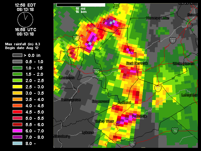
The rainfall maps for this system are crazy. 8+ inches in one area, barely an inch a few miles to the south. This is central PA but it's the same thing in this area.
There are big time orographic influences that have factored in to those totals. That part of central PA is rugged and mountainous.
-
1 hour ago, tdp146 said:
I’ve been on the edge of the sea breeze front all day. It will pour for 20 mins and 20 mins later the sun is out in full. I’ve lost track of how many downpours I’ve had today.
Sea breeze front can make for some real interesting weather out there. Way back in 1978 when I lived in East Northport a sea breeze front thunderstorm turned violent and produced marble sized hail and numerous CTG lightning strikes along with strong winds. It was one of the very few times I saw hail when I lived out that way.
-
57 minutes ago, bluewave said:
Pretty impressive sea breeze front eruption in the flash flood warned areas just inland from the South Shore.
There is a history of these convergence zones setting up west to east across LI. There was one a couple of years ago that dumped up to several inches of rain across NW Suffolk Cty.
-
2
-
-
24 Hour rainfall here was 3.15” from 10:00am yesterday.
-
4 hours ago, NJwx85 said:
Picked up some decent rains around 12:30AM up this way from that line. No thunder, just a good soaking for about 20 minutes or so.
I received a total of 0.83 from that line last night. Radar this hour looks similar to about 10:30pm last night with that healthy looking feature near Reading, PA
11/15-16 Coastal Storm/ULL Discussion
in New York City Metro
Posted
It’s coming in like a wall here. Like a snow squall. Mt Holly just upgraded me to a WSW.