

Tatamy
-
Posts
2,037 -
Joined
-
Last visited
Content Type
Profiles
Blogs
Forums
American Weather
Media Demo
Store
Gallery
Posts posted by Tatamy
-
-
1 hour ago, NycStormChaser said:2 hours ago, SRRTA22 said:Hm. We MCS? [mention=9582]NycStormChaser[/mention] [mention=682]Rtd208[/mention]
I think it weakens. But that is a ton of rain over PA. Hopefully we don't get into that because it would be flash flooding. It's only moving around 20 mph.
Plenty of rain out here today with on and off convection. Nice shelf cloud with the latest feature that moved through about 7:15pm. 1.10” on the day. NWS has a FFW for my area.
-
1 hour ago, etudiant said:
Then you remember to add the lightning protection and pretty soon you need an electrician. Roof tripods are not that simple.
I mounted mine on a shed. I grounded it with an 8’ 1/2” copper grounding rod purchased from HD and connected it with #6 coated stranded copper wire.
-
42 minutes ago, Tatamy said:
I think this was taken in Southhold
Correction - the picture I posted earlier was taken at the Patchogue Marina. This storm put down pea sized hail over at Fire Island Pines. You don’t hear too many reports of hail on Fire Island.
-
2 minutes ago, psv88 said:
that area of East Northport got slammed as well. Interesting drive to work today, many side streets still blocked off by trees and powerlines. I think our area saw localized gusts at or close to 70. Ive been through, Sandy, Irene, other storms with winds to 60, and this was on par with the worst of em. You dont see 100 foot oak trees snap at the trunk in 50 mph winds. A small tree can be uprooted, but not 4 foot in diameter tree trunks in health trees. The siding ripped from houses, nowhere near trees, indicates winds over 60. That initial burst of winds had immense power like nothing i have ever seen before, and we get strong winds out here very often.
Also, you cant take WU wind meters for shit. I have a Davis but the anenometer is 2 m off the ground and surrounded by trees and a fence.
I am not disagreeing with you on the WU wind meters. That is why I compared it to a Weatherflow. I also have a Davis but I can tell you that the Weatherflow uses a technology that better measures wind speed. We had a severe storm here on Saturday. The Ambient measured 23 mph. The Weatherflow measured 32 mph. These instruments are about 4 feet apart.
-
16 hours ago, psv88 said:
quite the drive around commack. tons of damage, some structural siding ripped off, etc. Winds to about 75-80 seem right
There is a WU station in East Northport that recorded a wind gust to 35 Mph as the storm approached just before 3pm. It is an Ambient station. I have an Ambient and a Weatherflow close to each other here and knowing the enhanced capability of the Weatherflow to measure gusts I would argue 50 - 60 mph. My brother lives in East Northport between Clay Pitts and 5th. In any case his street looks like a war zone with tree damage at least as bad as what you received.
-
44 minutes ago, Tatamy said:
This is another view of the approach of that cell that you posted earlier.
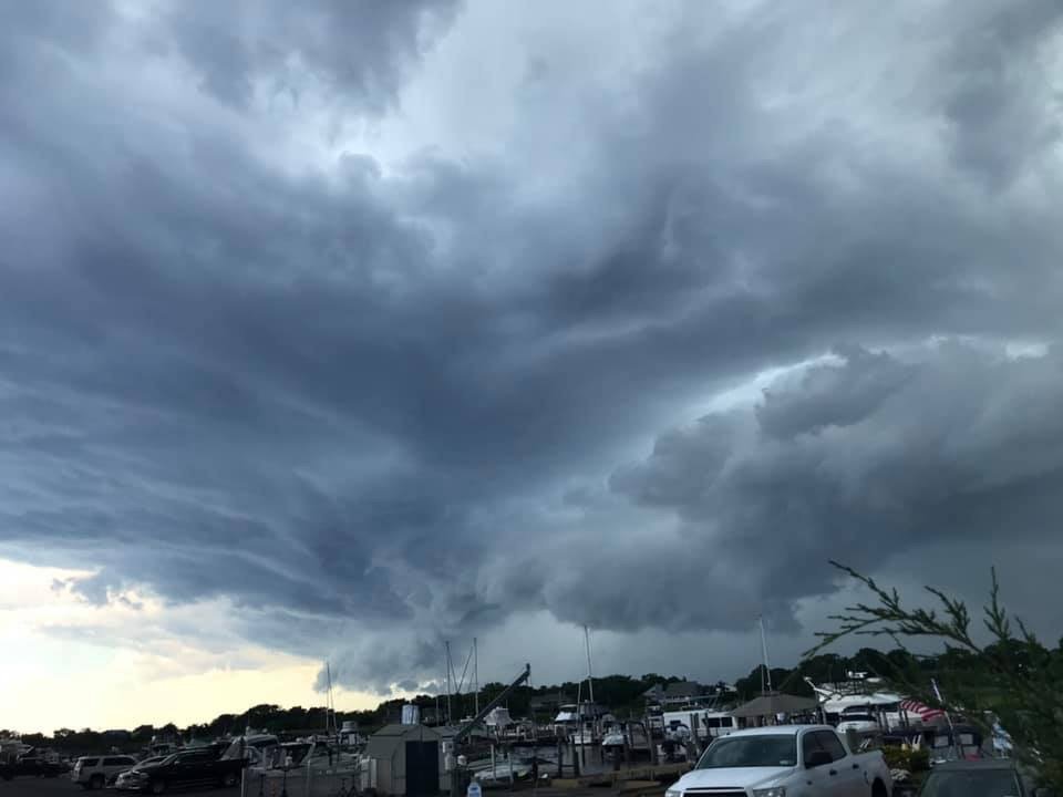
This was taken at the Patchogue Marina.
-
 1
1
-
-
13 hours ago, NycStormChaser said:13 hours ago, Rock888 said:^^^^ wow that is absolutely gorgeous
I swear it was close to putting down a waterspout but I wasn't far enough east to stay drive so I went back to my car
This is another view of the approach of that cell that you posted earlier.
-
3
-
-
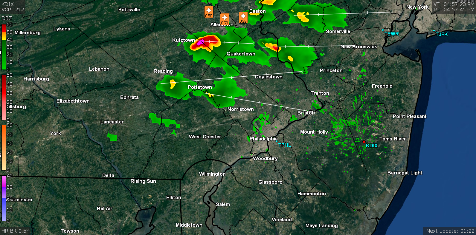
Nice hail cores currently with storms near Trenton, NJ and Pottstown, PA.
-
Plenty of lightning with these storms. Over 700 strikes in the past three hours on my Weatherflow detector.
-
10 minutes ago, TriPol said:
I haven't been this excited for partly cloudy skies since...
After the event that I had here last Sunday night I would have no problem if this ends up being a non event.
-
53 minutes ago, NJwx85 said:
Cannot post the loop because my server is down but HRRR shows next threat develops over Northern PA around 00z and clears the coast around 03-04z. Looks multi-cellular in nature.
20z HRRR has a quick moving cluster of storms that would cross parts of the area around 10pm.
-
1
-
-
10 minutes ago, Stormlover74 said:
it makes no sense. It doesn't even have the squall line over eastern PA right now
Squall line is stretching it. Ten lightning strikes on my Weatherflow in the past hour.
-
Minimal lightning activity so far with the cell just west of Allentown PA.
-
Lots of rain and loud booming thunder with these storms so far.
-
1
-
 1
1
-
-
Real nice lightning storm in progress here right now. It’s all CTC however.
-
Received 0.72” with the overnight storms. Highest wind gust 29 mph at 3 am.
-
3 hours ago, Hurricane Agnes said:
Anyone up in the Kutztown --> Easton area around? Looks like there are spotter reports of 0.70" hail up there. It's currently 73 here in NW Philly and mostly cloudy with breaks of sun.
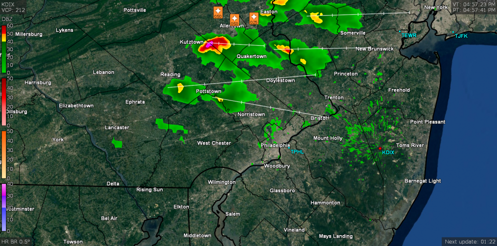
I am in the Bethlehem area. No hail here. The back door front is actually draped north to south over Bethlehem at this hour. There is a 15 temperature difference across the front. Weather Underground data shows this well.
-
2 hours ago, NycStormChaser said:
Yep. I've been shooting timelapses from high point since 230pm..all those cells slid just around me except this last one that's raining on me right now. I think I got some lightning I have to check when I get some but the timelapse will certainly be cool
I actually drove down from the Binghamton area earlier today and traveled under the incipient stages of this line. I have no doubt you obtained some great shots from your spot based upon what I saw coming down I380 from the Scranton area. These cells were low topped but spectacular to watch as they evolved. Tonight I am seeing something I have not seen in the 14 years I have been here (I moved from LI). The Back door / seebreeze front has just moved a couple of miles to my west. There is about a 15 degree temperature difference across Bethlehem tonight with this front. That pales in comparison to the 25 degree difference across NYC last night with the same front. It is very rare that a front like this gets this far west from NYC.
-
1
-
-
Just to make things interesting that line of showers and thunderstorms moving across eastern PA and NW NJ is putting down some CTG lightning.
-
Still moderate to heavy snow here in Bethlehem Twp. 6.2”. 33/32
-
Steady snow 31/29
-
5 minutes ago, snywx said:
Im in northwestern orange county and its already sleet here.
Obs up in Hazleton PA showing mixed precipitation up there and they are up over 1000’. Looking like we have ourselves an I84 special in the making tonight.
-
Light rain 34/28
-
1
-
-
Light rain 34/26
-
1
-
July 2019 General Discussions & Observations Thread
in New York City Metro
Posted
First round of storms were good rain producers - rec'd 0.67" with that round which is reforming in western and NW NJ. Lightning was minimal here but saw a nice shelf cloud as it arrived with a wind gust to 20 mph. Skies darkening here as the second round gets going near Allentown and heads our way.