

Tatamy
-
Posts
2,037 -
Joined
-
Last visited
Content Type
Profiles
Blogs
Forums
American Weather
Media Demo
Store
Gallery
Posts posted by Tatamy
-
-
Strong winds continue along the south shore. 42 mph recently at both Sayville and Babylon along the water.
-
Event total now up to 2.36” and still raining here in Bethlehem. Getting road closures in my area due to flooding. Model projections of 2 - 4” across northern NJ, eastern NY, and New England look good to me.
-
 1
1
-
-
1 minute ago, NJwx85 said:
They could have probably gotten the game in tonight if they had waited till 8:30 to start.
No.
-
Many reports of wind gusts over 40 mph on the south shore barrier beaches now. 41 mph at Fire Island light and 52 mph at Ocean Beach.
-
3 minutes ago, winterwx21 said:
Of course. I'm just pointing out that rainfall rates in this type of storm are nothing compared to summer downpours in t-storms. If it rained at this rate in the summer for an hour, you'd get a quarter to half inch and no one would think it's a big deal. It's not true very heavy rain like you get in summer storms, but I know it's impressive because it lasts many hours which gets you to heavy rainfall totals. To me this type of rain isn't exciting (although I'm glad we're getting a much needed soaking), but it's fine if others find it exciting. So far here I've picked up .85 of rain, but on radar the back edge of the steady moderate rain is already approaching Trenton. So we'll probably end up with a little over an inch here. Maybe an inch and a quarter. A good soaking but nothing to write home about IMO.
I thought the same as you two hours ago. Now I am almost at 2”. This event is delivering.
-
I have picked up 0.42” of an inch in the past 15 minutes to bring my event total up to 1.82”.
-
1
-
-
Event total now up to 1.40”
-
Recent gust to 45 mph at Smith Point Bridge.
-
22 minutes ago, bluewave said:
Beach Haven, NJ has SE gusts to 44 mph now.
41 mph at Ocean Beach on Fire Island in the last 10 minutes.
-
0.77” on the day so far. It looks like we will be good for about an inch out here with this event.
-
Light to moderate rain here. 0.36” so far with the event.
-
1 hour ago, forkyfork said:
This is another view of this waterspout as taken from Cherry Grove.

-
1
-
-
21 minutes ago, H2O said:
Cantoree
Did they decide where he was going to do his live shots from?
-
There has been a lot of talk about the hype regarding this storm. One of the things that I like to track is when it actually dawns on the populace down in S Florida that this threat is for real. I measure that by looking at the traffic apps showing highway speed conditions. In other storms I have seen those interstates backed up for hundreds of miles as people flee the storm. So far I have not seen any sign of the expected mass exodus on the highways down there. My thinking is that the West Palm Beach area is at the greatest risk of a direct hit early next week. If you or your friends or family are even considering leaving the area ahead of the storm I would not wait too much longer. My two cents anyways.
-
NWS Upton LSR:
PRELIMINARY LOCAL STORM REPORT...SUMMARY NATIONAL WEATHER SERVICE NEW YORK NY 1133 PM EDT THU AUG 22 2019 ..TIME... ...EVENT... ...CITY LOCATION... ...LAT.LON... ..DATE... ....MAG.... ..COUNTY LOCATION..ST.. ...SOURCE.... ..REMARKS.. 0834 PM TSTM WND DMG ROSELLE PARK 40.67N 74.27W 08/22/2019 UNION NJ LAW ENFORCEMENT TREE AND WIRES DOWN AT 9TH AVE AND 10TH ST. 0839 PM TSTM WND GST TRIBECA 40.72N 74.01W 08/22/2019 M58 MPH NEW YORK NY MESONET 0839 PM MARINE TSTM WIND 1 SSW BATTERY PARK 40.70N 74.01W 08/22/2019 M58 MPH ANZ338 NY MESONET 0853 PM MARINE TSTM WIND BREEZY POINT 40.55N 73.93W 08/22/2019 M42 MPH QUEENS NY WXFLOW 0900 PM MARINE TSTM WIND CITY ISLAND 40.87N 73.79W 08/22/2019 M40 MPH BRONX NY WXFLOW 0913 PM TSTM WND GST WANTAGH 40.67N 73.51W 08/22/2019 M61 MPH NASSAU NY TRAINED SPOTTER LARGES BRANCHES DOWN. 0915 PM MARINE TSTM WIND 2 SE POINT LOOKOUT 40.57N 73.56W 08/22/2019 M51 MPH ANZ355 NY WXFLOW 0925 PM TSTM WND DMG WANTAGH 40.67N 73.51W 08/22/2019 NASSAU NY TRAINED SPOTTER TREE DOWN ACROSS WANTAGH PARKWAY. 0930 PM MARINE TSTM WIND OAK BEACH 40.64N 73.29W 08/22/2019 M52 MPH SUFFOLK NY WXFLOW 0934 PM TSTM WND GST 1 ESE BABYLON 40.69N 73.31W 08/22/2019 M60 MPH SUFFOLK NY MESONET 0940 PM TSTM WND GST BRENTWOOD 40.78N 73.25W 08/22/2019 E61 MPH SUFFOLK NY PUBLIC 0942 PM MARINE TSTM WIND FIRE ISLAND CG 40.62N 73.26W 08/22/2019 M40 MPH SUFFOLK NY WXFLOW 0943 PM TSTM WND DMG BAY SHORE 40.73N 73.25W 08/22/2019 SUFFOLK NY NWS EMPLOYEE NUMEROUS TREES REPORTED DOWN AROUND TOWN. 0945 PM TSTM WND DMG ISLIP 40.73N 73.22W 08/22/2019 SUFFOLK NY PUBLIC LARGE TREE DOWN ON GRAND BLVD. 0945 PM MARINE TSTM WIND 1 S AMITY HARBOR 40.65N 73.40W 08/22/2019 M48 MPH ANZ345 NY WXFLOW 0953 PM TSTM WND DMG 1 S LAKE RONKONKOMA 40.82N 73.11W 08/22/2019 SUFFOLK NY MPING 3 INCH TREE LIMBS DOWN, POWER POLES SNAPPED 0955 PM MARINE TSTM WIND BLUE POINT 40.73N 73.03W 08/22/2019 M45 MPH SUFFOLK NY WXFLOW 1000 PM TSTM WND DMG RONKONKOMA 40.80N 73.12W 08/22/2019 SUFFOLK NY TRAINED SPOTTER LARGE TREE LIMBS RIPPED OFF TREE NEAR MICHAEL MURPHY PARK. 1005 PM TSTM WND DMG AMITYVILLE 40.67N 73.42W 08/22/2019 SUFFOLK NY SOCIAL MEDIA TREE DOWN. OUTDOOR FURNITURE DAMAGE. 1014 PM TSTM WND DMG NORTH BABYLON 40.72N 73.32W 08/22/2019 SUFFOLK NY SOCIAL MEDIA TREES DOWN DEER PARK AVE. 1016 PM TSTM WND DMG NORTH LINDENHURST 40.71N 73.38W 08/22/2019 SUFFOLK NY SOCIAL MEDIA MULTIPLE TREES DOWN ON COPIAGUE RD. 1112 PM TSTM WND DMG SHELTER ISLAND 41.08N 72.34W 08/22/2019 SUFFOLK NY FIRE DEPT/RESCUE TREES AND WIRES DOWN THROUGOUT ISLAND. -
4 minutes ago, NycStormChaser said:
I think there's two areas of a possible tornado touch down on long Island.
I can’t rule out a tornado however there is a very large area of wind damage and resulting power outages on the island right now. I think that this is mostly the result of straight line wind damage.
-
1
-
-
1 minute ago, SnoSki14 said:
I knew that bow was powerful when its outflow produced pretty Gusty winds despite being well to my north back in NJ.
Tornado perhaps?
This is mostly straight line wind damage. The large area of strong wind reports and radar presentation would strongly support that. I do believe that after Upton does their damage survey that there will be a spot or two where winds will have been determined to reach close to 100 mph.
-
Big stuff went down out there on the Island tonight. The lack of posts on this thread in the past half hour speaks for itself as most are offline now.
-
A gust to 65 mph was measured in the vicinity of the Sayville Ferry dock (Weather Underground).
-
Have some wind reports to share from Fire Island from tonight’s event:
Fire Island Light 46 mph
Fair Harbor 46 mph
Atlantique 40 mph
Point of Woods 40 mph
Cherry Grove 40 mph
Fire Island Pines 35 mph
These gusts all occurred around 10 pm. It is amazing that these stations are still up and reporting after this event.
-
The cell that popped near Allentown a short while ago dropped a quick 0.96” here. No strong winds or CTG lightning with it however.
-
1
-
-
41 minutes ago, bluewave said:
The worst of the storm missed just to my south over the barrier islands.
Gilgo Beach
https://mesowest.utah.edu/cgi-bin/droman/meso_base_dyn.cgi?stn=F3143&unit=0&timetype=GMT
17:46 76.0 68.6 70.9 78 11.0 21.0 WNW 29.74 29.75 0.0 0.13 0.10 N/A 17:31 76.0 67.9 70.4 76 12.0 30.0 NNW 29.74 29.75 0.0 0.13 0.10 N/A 17:16 80.0 69.7 72.7 71 35.0 65.0 WNW 29.69 29.70 0.0 0.06 0.03 N/A 17:01 81.0 71.9 74.5 74 19.0 23.0 SSW 29.66 29.67 9.0 0.06 0.03 N/A 1 I have a station mounted at my brother’s house at Cherry Grove. It gusted to 26 mph at 8pm. It’s mounted slightly below the roof line so it does not get the full exposure to the wind. Based upon how it is set up I would estimate actual winds gusted to 40 mph there at that time.
-
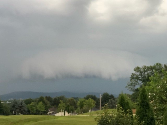
Shelf cloud from earlier with the second round of storms.
-
3
-
-
Lots of lightning just to my SW as the next batch of storms approaches.
-
1
-


October 2019 General Discussions & Observations Thread
in New York City Metro
Posted
Winds had been relatively light here during the past hour however they have just started to really increase from the west and NW. Just had a gust to 24 mph from the west.